Ballard County occupies Kentucky’s far western corner, where Wickliffe serves as the county seat and a group of small communities sits between two of the country’s major rivers. The Ohio River borders the north, the Mississippi River borders the west, and their confluence gives the county an unusually broad floodplain and wetland landscape. KY 51, KY 60, KY 62, KY 286, KY 358, KY 473, KY 802, and KY 121 connect Wickliffe with La Center, Kevil, Barlow, Blandville, and the surrounding farm country. High-resolution map files are available for download in the section below.
This guide follows the county seat, the city connections, the Ohio–Mississippi floodplain, internal creeks, and terrain ranging from about 88 to 151 meters. WebP previews are available for quick viewing, and the matching high-resolution JPG files can be downloaded together in one ZIP for printing, classroom work, or offline reference.
Table of Contents
Wickliffe anchors the county near KY 51, KY 62, and the river confluence
Wickliffe sits at the southwestern tip of Ballard County, close to KY 51 and KY 62 and within easy reach of the Mississippi–Ohio confluence. Barlow lies to the northeast, La Center occupies the county interior, and Kevil provides an eastern reference near KY 60. On the general map, Wickliffe is the clearest point for understanding county government, the major rivers, and the southwest road network.
Ballard County’s official website identifies Wickliffe as the county seat and notes that the county was created in 1842 from parts of Hickman and McCracken counties. The City of Wickliffe also records the Ballard County Courthouse as a 1903 building that was refurbished in 1993. Those civic functions remain concentrated in a town that is small in population but central to county administration.
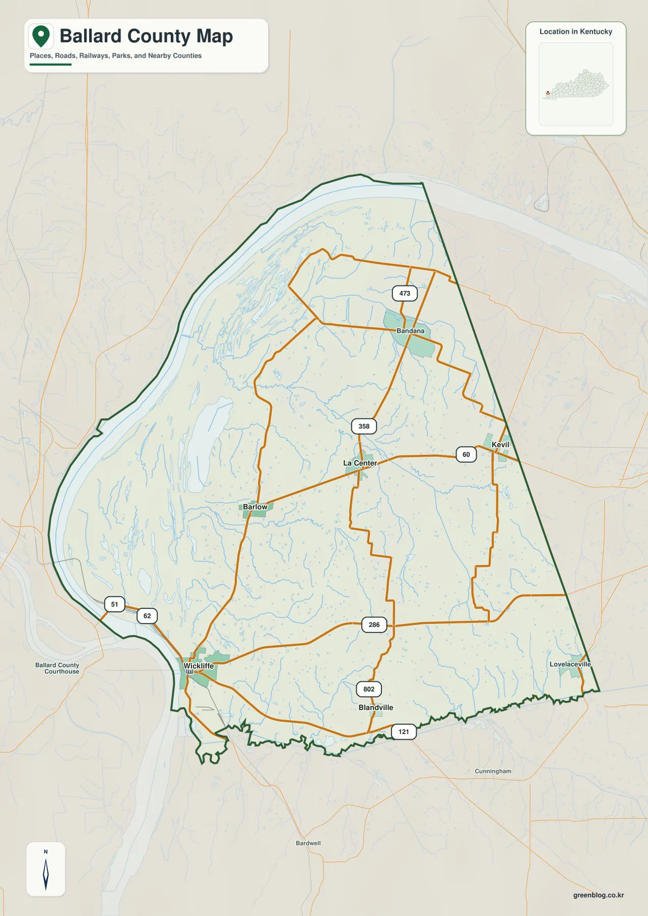
La Center sits near the center between KY 358 and KY 60, while Kevil lies farther east near the McCracken County side. Barlow provides a reference on the road corridor north of Wickliffe, and Blandville occupies the southeastern interior near KY 802 and KY 286. Bandana marks the northern rural area around KY 473.
The city-connections panel compares Wickliffe with four nearby communities
The supplied city-connections panel places Wickliffe at an index value of 797, La Center at 694, Kevil at 624, Barlow at 564, and Blandville at 107. These are map index values rather than current official population estimates. The panel also labels straight-line distances from Wickliffe of about 10 miles to La Center, 14 miles to Kevil, 6 miles to Barlow, and 7 miles to Blandville; they are not driving distances.
The communities are close in mileage but not in landscape. Barlow shares more of the low western river country, while Blandville sits in the hillier southeastern interior. La Center serves the central road network, and Kevil provides the strongest eastern reference toward McCracken County.
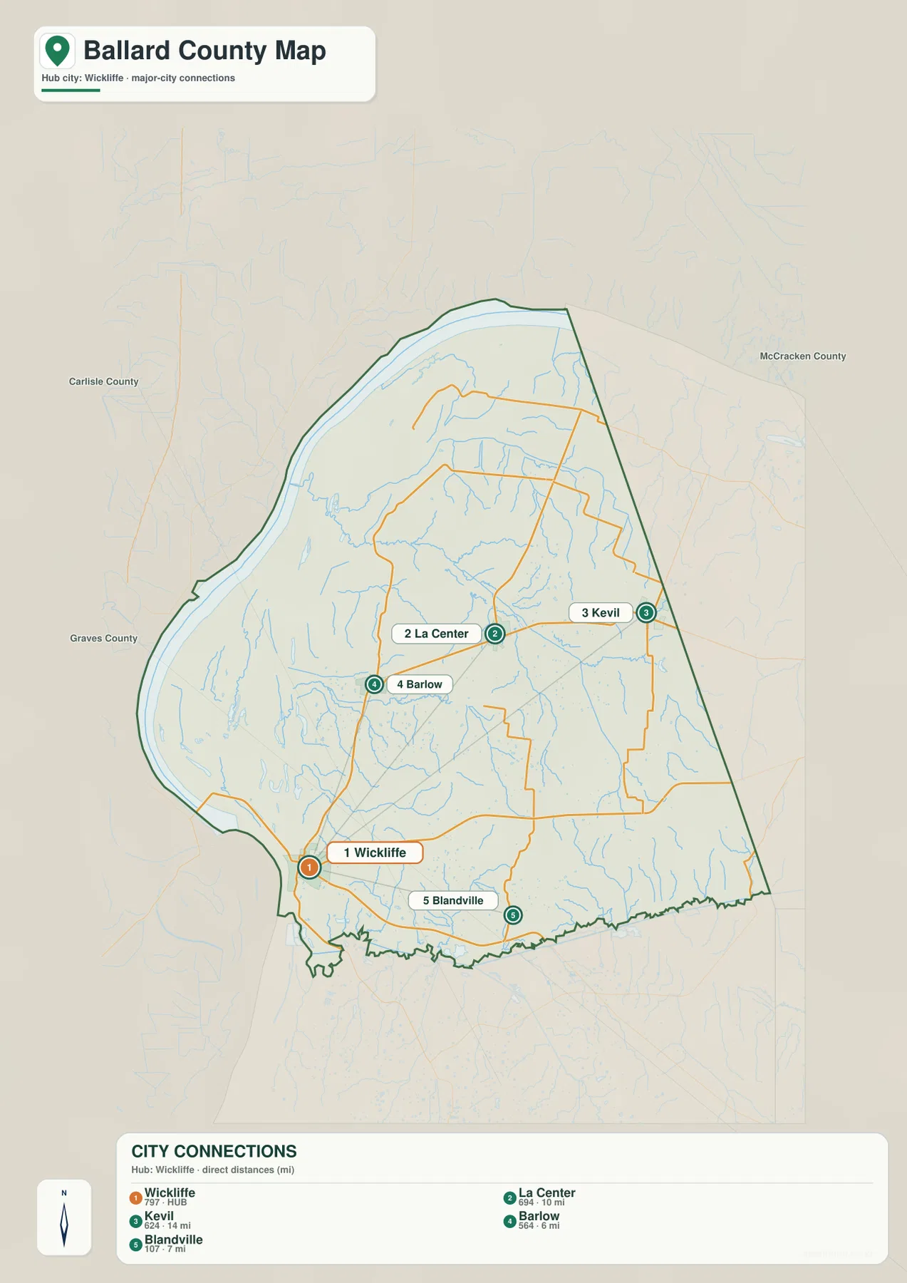
Ballard County is rural enough that the city ranking tells only part of the story. Floodplain farms, wetlands, creeks, and low river terraces occupy large areas between the communities, so the water and elevation views are especially important for understanding how the county changes from west to east.
The Ohio and Mississippi rivers define the county’s northern and western edges
Ballard County’s official description places the Ohio River along the north and the Mississippi River along the west. On the water map, those rivers dwarf the internal creeks and frame a very broad lowland. Old channels, ponds, shallow lakes, and wetland depressions remain across the western floodplain.
Clanton Creek crosses the northern interior, while Humphrey Creek runs through the central county and is joined by Little Humphrey Creek. Shawnee Creek and Cane Creek form long drainage corridors farther south. Mitchell Lake, Clear Pond, Axe Lake, Prairie Lake, Minor Lake, and Swan Pond are among the named waters concentrated in the western lowlands.
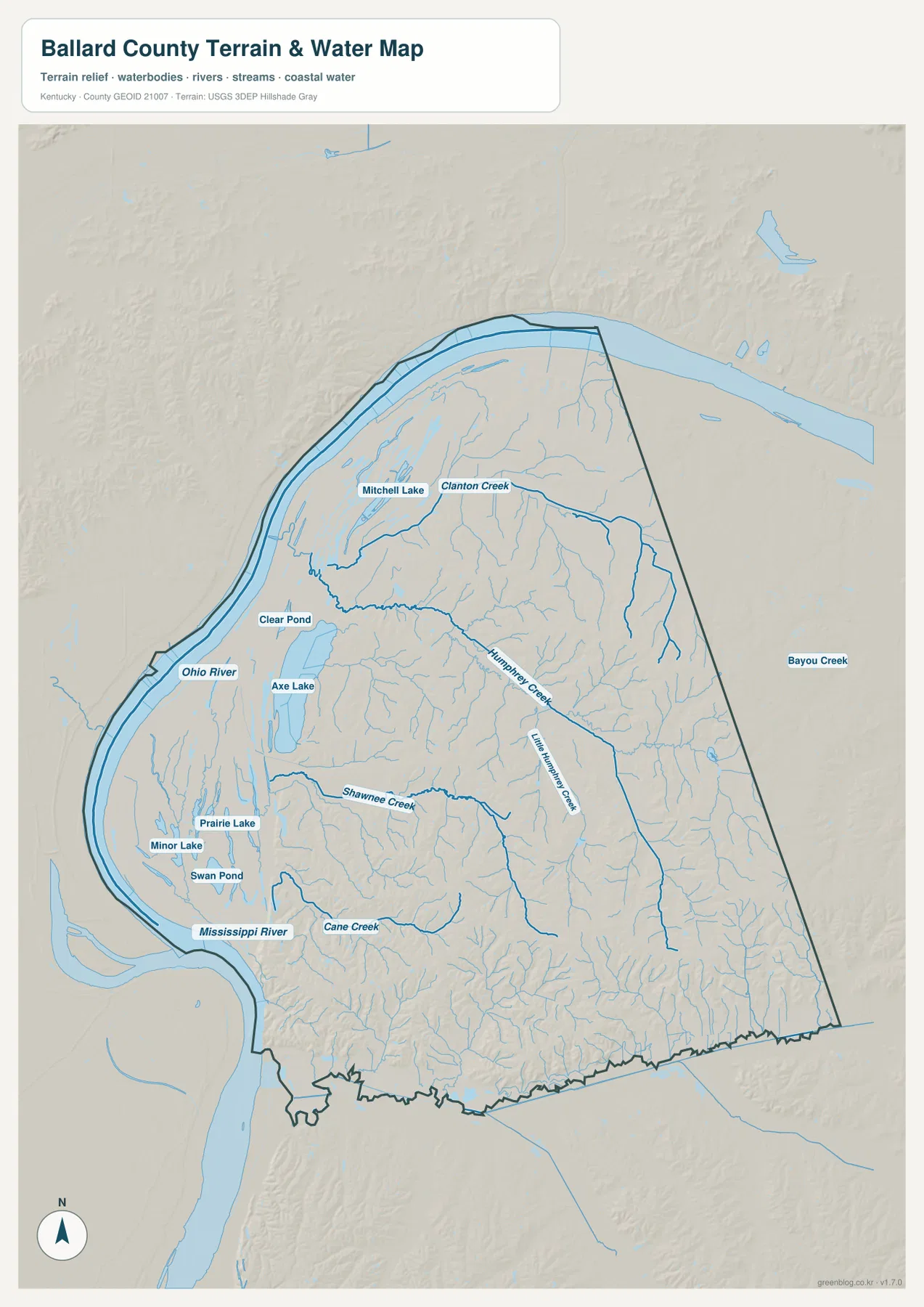
Ballard Wildlife Management Area preserves a large piece of that riverine environment. The current Kentucky Department of Fish and Wildlife Resources listing describes a management area of more than 8,000 acres with wetlands making up most of the mapped habitat. That setting matches the low, water-rich western side visible on the package maps.
This image is intended for geographic reference rather than flood-risk, navigation, water-quality, parcel, or legal-access decisions. River levels and public-land rules can change, so current agency information should be used whenever boating, hunting, fishing, or flood conditions matter.
Elevation from 88 to 151 meters separates floodplain flats from the eastern hills
The elevation surface ranges from about 88 to 151 meters, with a mean near 113 meters. The Mississippi and Ohio river margins appear as broad dark-green lowlands, especially across the west and northwest. Tan and brown uplands become much more prominent in the east and southeast.
The western floodplain is remarkably flat because it has been shaped by repeated river movement and deposition. Moving inland, Humphrey Creek and Shawnee Creek cut green valleys into progressively higher terrain. The change is gradual but obvious enough that the La Center and Kevil sides look much more dissected than the Wickliffe–Barlow river plain.
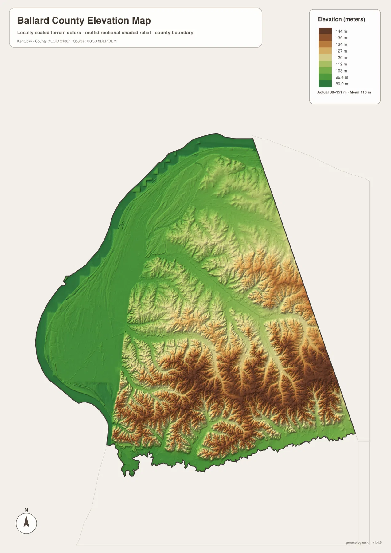
Blandville and the southeastern boundary lie among some of the strongest local relief, where short ridges and drainage cuts repeat closely. By contrast, the land north of Wickliffe and west of Barlow remains broad and level beside the major rivers.
The elevation surface is generalized for county-scale comparison. It is not survey-grade or engineering-grade measurement and should not be used for parcel elevations, construction grades, drainage design, flood determinations, or legal boundary work.
Wickliffe Mounds overlooks the confluence from higher ground
The Kentucky Archaeological Survey and National Park Service describe Wickliffe Mounds as a Mississippian cultural site on a bluff overlooking the Ohio–Mississippi confluence. The site preserves platform mounds, burial mounds, a plaza, and traces of residential areas associated with a village occupied roughly between A.D. 1100 and 1350.
Wickliffe Mounds State Historic Site now combines archaeological interpretation with views across the river country. Comparing the site location with the elevation map makes the setting especially clear: the ancient village occupied higher ground directly above one of the largest floodplain landscapes in Kentucky.
Ballard County combines Jackson Purchase history with river transport and wetland farming
The county government describes Ballard County as part of the Jackson Purchase and notes that it was established in 1842. It was named for Captain Bland Ballard, a Kentucky soldier and legislator. Its location at the Ohio–Mississippi confluence meant that river movement, rich alluvial soils, and access to transportation shaped settlement and agriculture from the beginning.
Wickliffe’s courthouse, the archaeological mounds, the floodplain farms, and the wildlife-management wetlands represent very different periods of that history. Seen together, they explain why a small rural county at the edge of Kentucky has such a strong connection to river geography.
Travel from Wickliffe toward La Center and Kevil climbs out of the floodplain
Traveling from Wickliffe toward Barlow and La Center moves gradually away from the Mississippi River floodplain and into more rolling interior terrain. East of La Center toward Kevil, KY 60 crosses a denser network of creeks and short valleys as the land becomes more dissected.
The opposite direction toward the western river margin stays much flatter and wetter, with oxbow-like lakes, ponds, drainage ditches, and wetland areas near the major rivers. Comparing the general, water, and elevation views makes this short west-to-east transition one of the clearest geographic patterns in Ballard County.
For posters, classroom prints, or presentation slides, use the original JPG files in the download archive rather than enlarging the web previews. Small route labels, creek names, city-connection text, and the elevation legend remain clearer at the higher resolution.
Frequently Asked Questions
Are the 797, 694, 624, 564, and 107 values current populations?
No. Wickliffe 797, La Center 694, Kevil 624, Barlow 564, and Blandville 107 are map index values supplied with this package. The 10-, 14-, 6-, and 7-mile labels are also straight-line map distances from Wickliffe, not driving distances.
Where is Wickliffe Mounds?
Wickliffe Mounds State Historic Site is in Wickliffe on higher ground overlooking the Ohio–Mississippi confluence. It preserves a Mississippian village and mound complex and provides one of the clearest links between the county’s archaeology and river geography.
Can the 88–151 meter elevation image be used for flood or land surveying decisions?
No. It is a generalized county-scale terrain image for comparing low river floodplains with higher eastern and southeastern hills. Flood determinations, parcel elevations, engineering design, and legal boundary work require purpose-built official data and, where needed, professional surveying.
Map File Information
The archive contains the Ballard County, Kentucky general county map, city-connections map, terrain-and-water map, and elevation map as original high-resolution JPG files.
- Included Files: Use only the versions confirmed in the article and supplied images
- File Type: Use the confirmed download contents
- Intended Use: Printing, education, presentations, and map-based projects
Related Maps
Sources and references
- Ballard County, Kentucky official website — county seat, 1842 formation, Ohio–Mississippi river boundaries, and Jackson Purchase background
- Kentucky Archaeological Survey: Wickliffe Mounds State Historic Site — Mississippian village, mounds, plaza, and site history
- National Park Service: Wickliffe Mounds — confluence setting and archaeological interpretation
- Kentucky Department of Fish and Wildlife Resources: Ballard WMA — wetland habitat and public-land information
- U.S. Census Bureau TIGER/Line Shapefiles — county boundary and geographic reference data
- USGS 3D Elevation Program — elevation and terrain reference data
Green Map creates custom-edited map images using open geographic data sources such as geoBoundaries, Natural Earth, OpenStreetMap, and government open data. These maps are edited visual materials, not raw data files, and are provided for education, documents, presentations, and graphic reference.