Adair County lies in south-central Kentucky, where Columbia serves as the county seat and the main road reference within a landscape of rolling ridges, narrow creek valleys, and the southern arms of Green River Lake. KY 55, KY 61, and KY 80 meet around Columbia, while KY 551, KY 767, KY 531, KY 92, and several other state routes spread into the surrounding rural communities. The county becomes noticeably lower around the Green River system and more strongly dissected across the eastern and southern hills. High-resolution map files are available for download in the section below.
This guide follows Columbia, the main roads, Green River Lake, Russell Creek, and terrain ranging from about 179 to 343 meters. WebP previews are available for quick viewing, and the matching high-resolution JPG files can be downloaded together in one ZIP for printing, classroom work, or offline reference.
Table of Contents
Columbia anchors the county where several state routes converge
Columbia sits near the center of Adair County, with KY 55, KY 61, and KY 80 forming the clearest road framework. KY 767 and KY 551 connect nearby rural areas, while KY 531, KY 76, and KY 206 spread toward the eastern side. South of Columbia, KY 92, KY 55, KY 900, and KY 704 provide references toward the Clinton and Cumberland County boundaries.
Adair County’s official site describes Columbia’s Public Square as a historic center of the community. A Kentucky Historical Society marker records that the court selected the public square as the permanent seat of justice in 1802, and the present Adair County Courthouse was completed in 1887. The modern road pattern and the long-standing civic center therefore occupy the same part of the county.
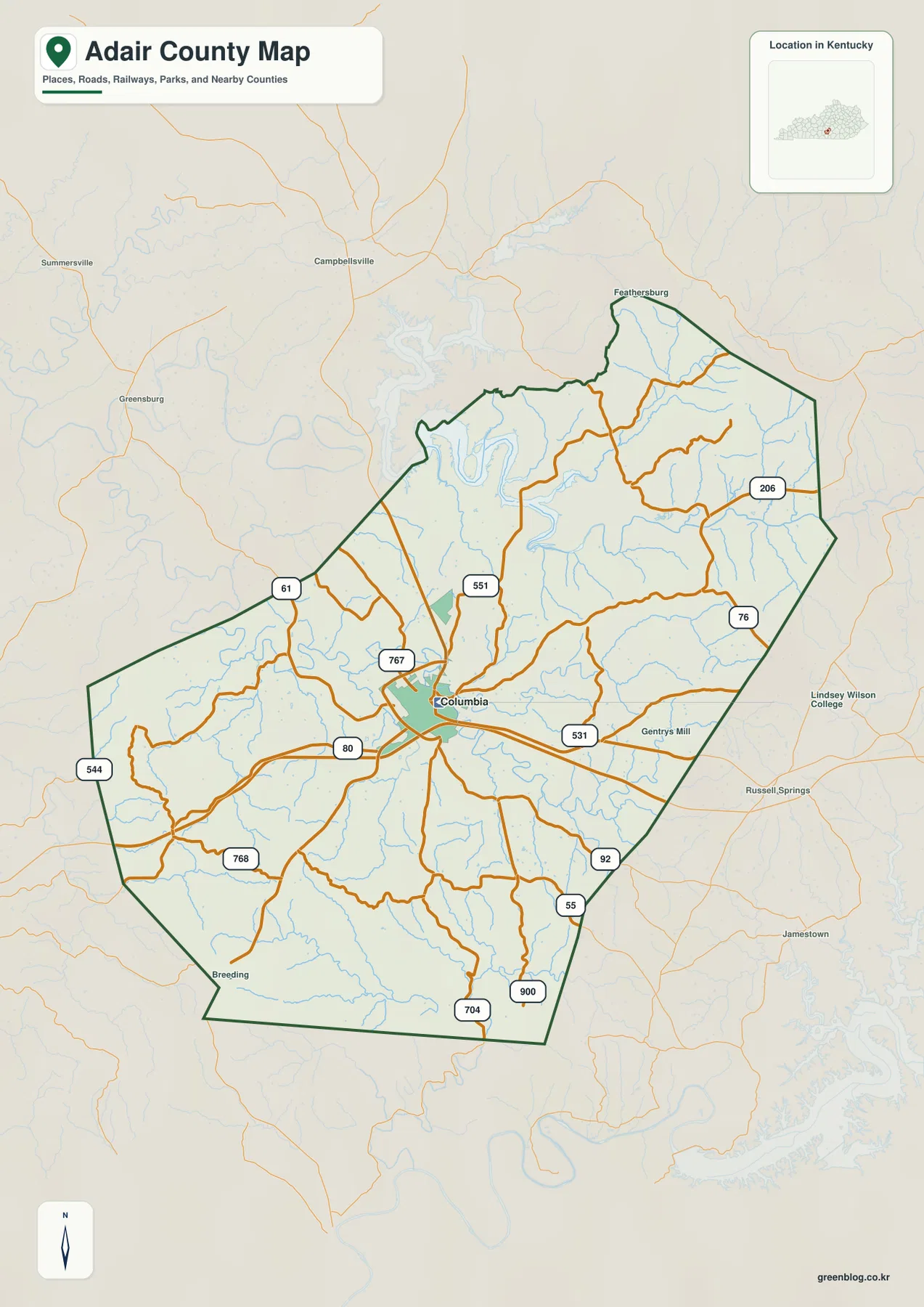
Campbellsville and Summersville appear beyond the northern side of the county, Greensburg lies to the west, and Russell Springs and Jamestown provide eastern and southeastern references. Inside the county, the settlement pattern is less about several large towns and more about routes radiating from Columbia through rural ridges and creek bottoms.
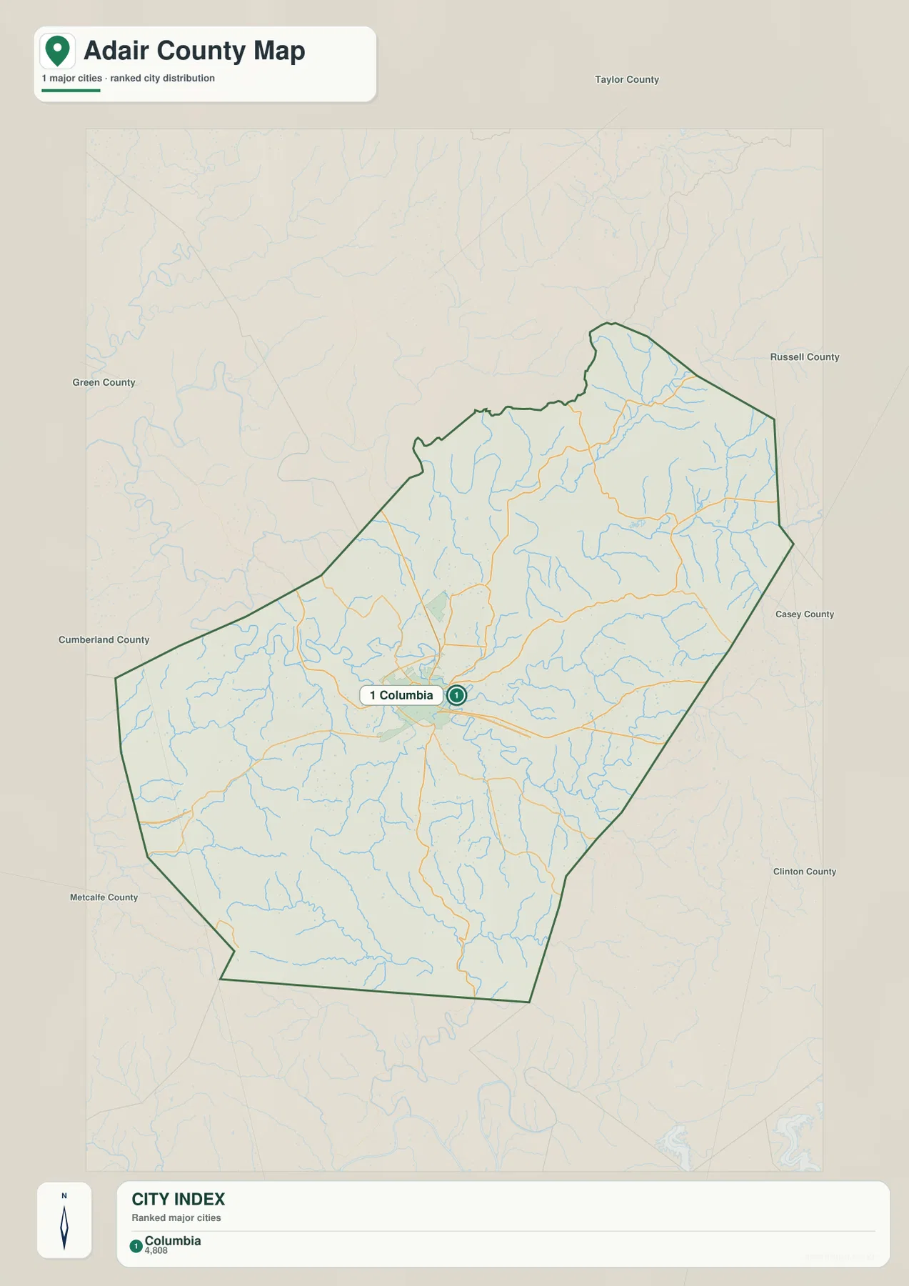
Columbia is the only community ranked on the supplied city panel
The supplied city panel lists Columbia at an index value of 4,808 and does not rank another Adair County city. The number is a map index rather than a current official population estimate. For this county, the panel is best read as a statement of Columbia’s central role rather than as a full population table.
Smaller place names such as Breeding and Gentrys Mill appear on the general map, but they are not part of the ranked city dataset. That distinction matters because the city image should not be used to infer official population figures for every community shown elsewhere on the package.
Columbia’s importance also extends beyond the map index. County government and the courthouse square are located there, and Lindsey Wilson University adds a major educational institution to the same small urban center. Those functions reinforce the road network’s strong focus on Columbia.
Green River Lake and the Green River system dominate the northern water map
Green River Lake is the largest water body visible inside the package, with long reservoir arms entering the northwestern side of Adair County. Butler Creek and White Oak Creek approach the lake through narrow valleys, while the broader Green River system continues across the northern part of the county.
The Green River creates a pronounced low corridor across the north and northeast, where Casey Creek joins the drainage network. The surrounding surface is deeply cut by short tributaries, so the difference between ridge tops and watercourses is much clearer on the terrain image than on the road map.
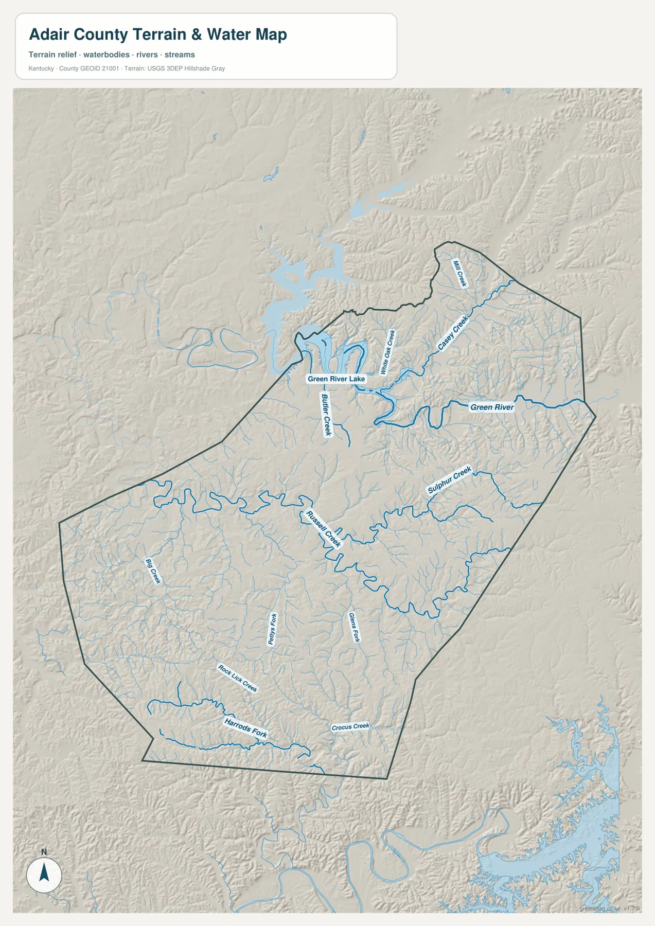
Russell Creek is one of the strongest internal drainage lines. It passes through the central and eastern county and receives Sulphur Creek and many shorter tributaries. Farther south, Harrods Fork, Rock Lick Creek, and Crocus Creek create long separate valleys, while Big Creek divides the western uplands.
This image is intended for geographic reference rather than floodplain, navigation, water-quality, parcel, or legal-access decisions. Lake and stream conditions can change, so current agency information should be used whenever boating, fishing, or shoreline access depends on water level or local rules.
Elevation from 179 to 343 meters separates river bottoms from the eastern and southern hills
The elevation surface ranges from about 179 to 343 meters, with a mean near 260 meters. Dark green lowlands follow Green River Lake and the Green River system, while higher tan and brown terrain becomes much more common across the east, southeast, and southwest.
The Green River and Casey Creek form broad low corridors in the northern and northeastern county. Around Columbia, intermediate uplands alternate with the Russell Creek valley. Farther south, Harrods Fork and Rock Lick Creek cut long channels into higher terrain and leave narrow ridges between neighboring tributaries.
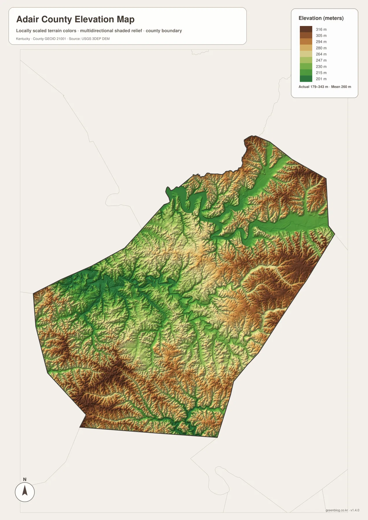
The western side is also far from flat. Big Creek and its smaller tributaries cut green valleys through uplands that rise again toward the southwest. This repeated sequence of ridge and creek bottom helps explain why many rural roads bend through the landscape rather than following long straight alignments.
The elevation surface is generalized for county-scale comparison. It is not survey-grade or engineering-grade measurement and should not be used for parcel elevations, construction grades, drainage design, or legal boundary work.
Columbia Public Square preserves more than two centuries of county-seat history
A Kentucky Historical Society marker records that on June 28, 1802, the county court ordered a permanent seat of justice on Columbia’s public square. The first courthouse was completed in 1806, and the current courthouse was designed by McDonald Brothers of Louisville and built in 1887.
Another historical marker on the courthouse lawn explains that Adair County was named in 1801 for John Adair, who later served as governor of Kentucky. The county’s civic history therefore remains concentrated at the same central square that still anchors downtown Columbia today.
The Daniel Trabue House connects modern Columbia with its pioneer-era beginnings
The Kentucky Historical Society identifies Daniel Trabue as one of Columbia’s founders. Trabue built the original portion of his house around 1823 and served the community as a trustee, sheriff, and justice of the peace while also operating a grist mill, inn, and store.
Columbia-Adair County Tourism continues to feature the Trabue-Russell House as a local heritage site. It provides a tangible link between the present-day courthouse town and the much earlier period when Columbia was developing as a small south-central Kentucky settlement.
Lindsey Wilson University adds an educational center to the county seat
Lindsey Wilson University’s official history traces the institution to the Lindsey Wilson Training School, founded in 1903 and opened for classes in 1904. The campus remains in Columbia, placing higher education close to the courthouse square and the county’s main road junctions.
The university is not a dominant physical feature on the county-scale map, but it helps explain Columbia’s regional role. Government, education, retail services, and the road network all concentrate in the same community while most of Adair County remains rural.
Routes toward Green River Lake and the southern forks cross very different terrain
Traveling northwest from Columbia toward Green River Lake leads into lower terrain as narrow valleys open toward the reservoir. Heading south on the KY 55, KY 92, and KY 704 side instead crosses hillier country cut by Harrods Fork, Rock Lick Creek, Crocus Creek, and numerous short tributaries.
East of Columbia, the KY 80, KY 531, and KY 76 side follows the Russell Creek and Sulphur Creek drainage network before approaching the lower Green River system. Comparing the road, water, and elevation views together makes these changes much easier to see.
For posters, classroom prints, or presentation slides, use the original JPG files in the download archive rather than enlarging the web previews. Small route shields, creek names, Columbia labels, and the elevation legend remain clearer at the higher resolution.
Frequently Asked Questions
Why does the city map show only Columbia?
The supplied ranked-city dataset contains one Adair County entry: Columbia at 4,808. Other place names appear on the general county map, but they are not included in the city ranking panel, and 4,808 should not be treated as a current official population count.
Where is Green River Lake on the Adair County maps?
Green River Lake enters the northwestern side of the county and connects with the broader Green River drainage. It is one of the largest natural references on the package and occupies lower terrain than much of the central and southern county.
Can the 179–343 meter elevation image be used for surveying?
No. It is a generalized county-scale terrain image for comparing Green River lowlands with higher eastern and southern ridges. Parcel elevations, engineering grades, drainage design, and legal boundary work require more precise official data and, where needed, professional surveying.
Map File Information
The archive contains the Adair County, Kentucky general county map, city map, terrain-and-water map, and elevation map as original high-resolution JPG files.
- Included Files: Use only the versions confirmed in the article and supplied images
- File Type: Use the confirmed download contents
- Intended Use: Printing, education, presentations, and map-based projects
Related Maps
Sources and references
- Adair County, Kentucky: About — county background, Columbia Public Square, and Green River Lake
- Kentucky Historical Society: Adair County Courthouse — Columbia courthouse square and 1887 courthouse history
- Kentucky Historical Society: Daniel Trabue — Columbia founder and Trabue House history
- Lindsey Wilson University: History — founding and development of the Columbia institution
- Columbia-Adair County Tourism: Recreation — Green River Lake, Trabue Russell House, and local recreation
- USGS 3D Elevation Program — elevation and terrain reference data
Green Map creates custom-edited map images using open geographic data sources such as geoBoundaries, Natural Earth, OpenStreetMap, and government open data. These maps are edited visual materials, not raw data files, and are provided for education, documents, presentations, and graphic reference.