Stanton County occupies the far southwestern High Plains of Kansas, close to the Colorado state line. Johnson City is the county seat and main road center, while Manter is the smaller community to the west. US 160 links the two towns, and K-27 crosses north–south near Johnson City. Bear Creek, Little Bear Creek, and Sandy Arroyo Creek cut surprisingly deep valleys through an otherwise broad upland surface. High-resolution map files are available for download in the section below.
This guide follows Johnson City and Manter across the road, water, and elevation views, with terrain ranging from about 949 to 1,131 meters. WebP previews are available for quick viewing, and the matching high-resolution JPG files can be downloaded together in one ZIP for printing, classroom work, or offline reference.
Table of Contents
Johnson City anchors the county at the US 160 and K-27 junction
Johnson City sits slightly east of the county center where US 160 meets K-27. US 160 arrives from the Colorado side through Manter and then turns east toward Grant County, while K-27 runs north toward Hamilton County and south toward Morton County. This crossroads gives Johnson City an outsized role in a sparsely settled county.
The Kansas Historical Society identifies Johnson City as the Stanton County seat. The county was established in 1873 and organized in 1887, and the seat eventually settled at Johnson City. Stanton County government remains based at 201 North Main Street in the city.
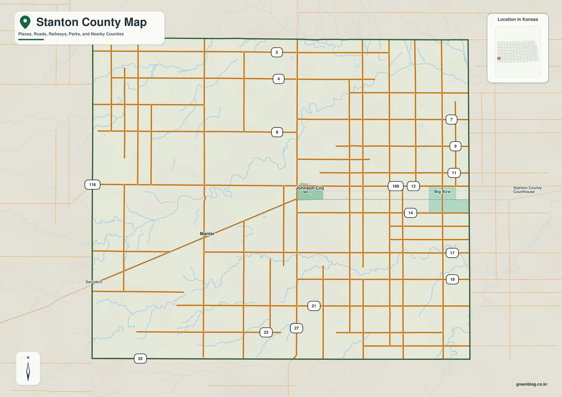
Manter lies west-southwest of Johnson City along US 160 and serves as the first incorporated place for travelers entering from the Colorado side. Outside the two towns, the map is dominated by a rectangular rural road grid and broad agricultural land. Big Bow and other small place labels provide local reference points, but no other settlement approaches Johnson City in scale.
The ranked city panel contains Johnson City and Manter
The city map lists Johnson City at 1,549 and Manter at 142. These are map index values rather than current official population estimates. The wide gap between them makes the settlement pattern unusually simple: one clear county center and one much smaller western town.
The two communities are connected by US 160 across open High Plains farmland. Johnson City also benefits from the north–south K-27 corridor, while Manter is tied more directly to the Colorado approach. In this county, road orientation often matters more than town density because long rural stretches separate the few built-up areas.
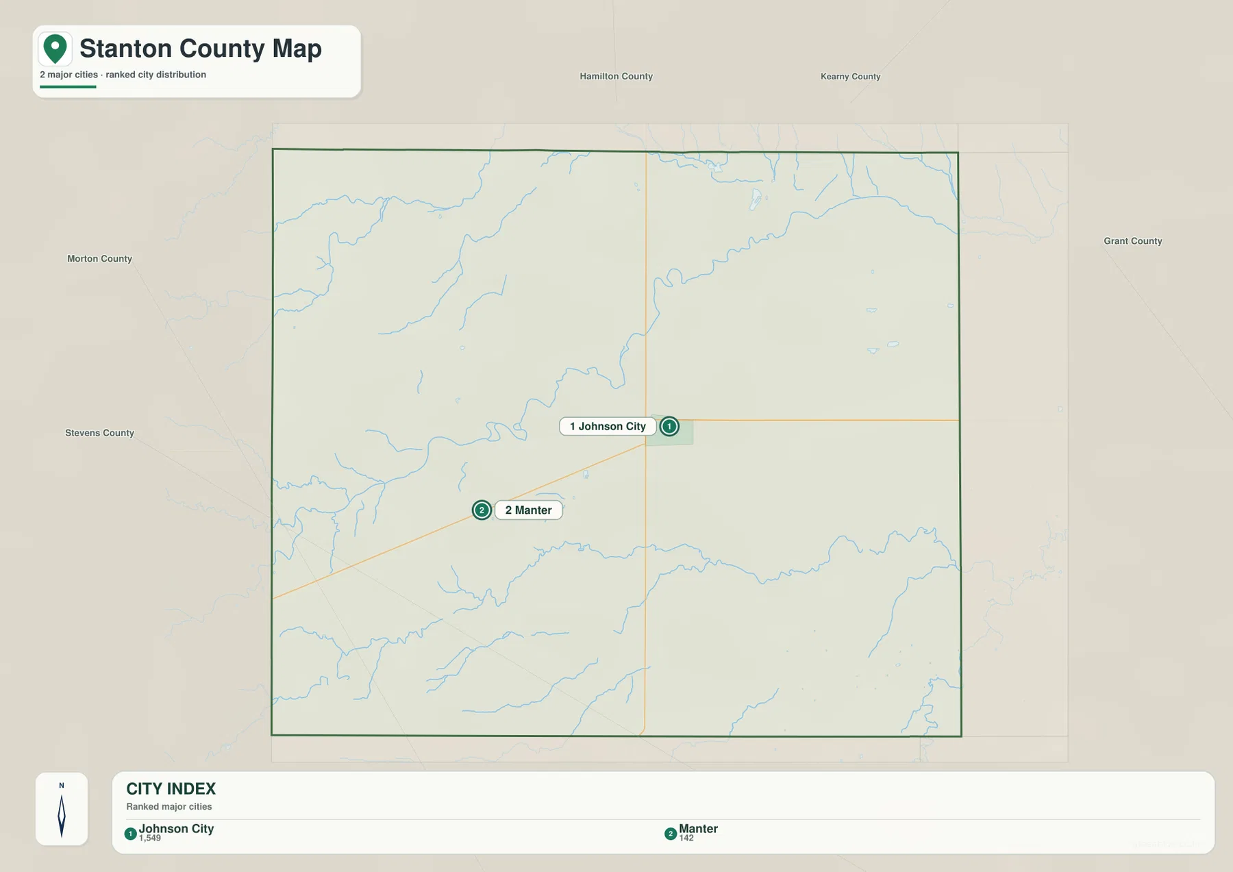
Kansas Historical Society census material records 2,084 residents in Stanton County in 2020 and identifies Big Bow, Manter, and Stanton townships. Those official figures and the supplied city index are different datasets, but both reflect a very lightly populated High Plains county centered on Johnson City.
Bear Creek and Sandy Arroyo Creek carve the main valleys
Bear Creek is the strongest water feature on the terrain map. It enters from the west, bends through the center and northern interior, and continues toward the east. Its valley cuts below the surrounding plain and becomes a useful natural reference near the K-27 corridor north of Johnson City.
Little Bear Creek forms a separate northern valley close to the western side, while Sandy Arroyo Creek crosses the southern half from west toward east. Numerous short tributaries descend from the uplands into these channels, creating a much more dissected surface than the road map alone suggests.
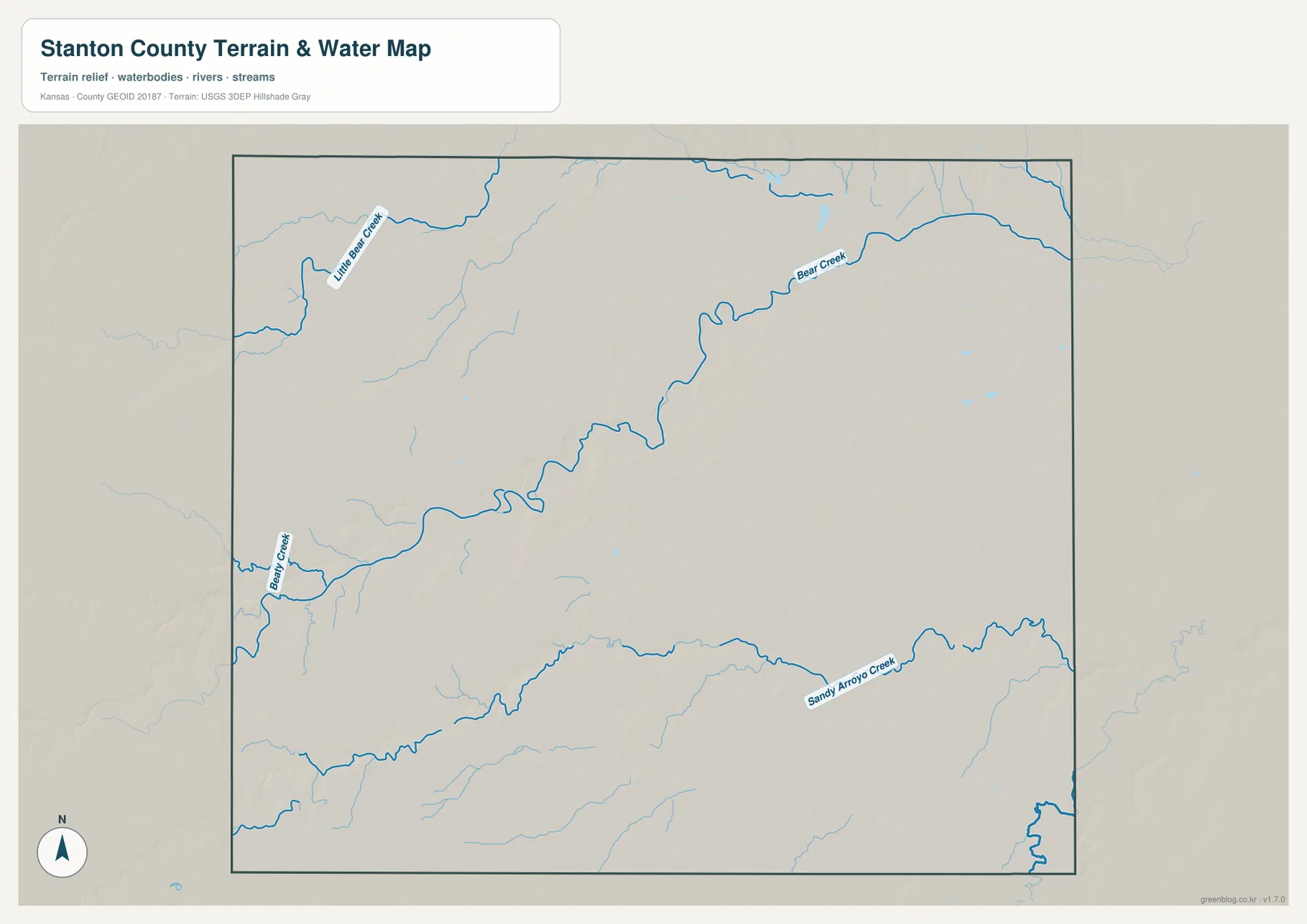
Large lakes and reservoirs do not dominate this county. Instead, intermittent streams, arroyo valleys, and small water bodies provide the main drainage structure. That pattern is typical of a semi-arid High Plains landscape where water features can vary significantly with season and rainfall.
This image is intended for geographic reference rather than floodplain, navigation, water-quality, parcel, or legal-access decisions. Creek conditions can change quickly, so current official information should be used whenever access or safety matters.
Elevation from 949 to 1,131 meters drops from the Colorado side toward the east
The elevation surface ranges from about 949 to 1,131 meters, with a mean near 1,028 meters. Higher brown and tan ground occupies much of the west and southwest, while greener lower terrain becomes more extensive toward the eastern side of the county.
Bear Creek and Little Bear Creek cut into the western uplands and create narrow low corridors. Sandy Arroyo Creek does the same across the southern half. The broad west-to-east decline is therefore interrupted by a network of locally steep creek cuts and small ridges.
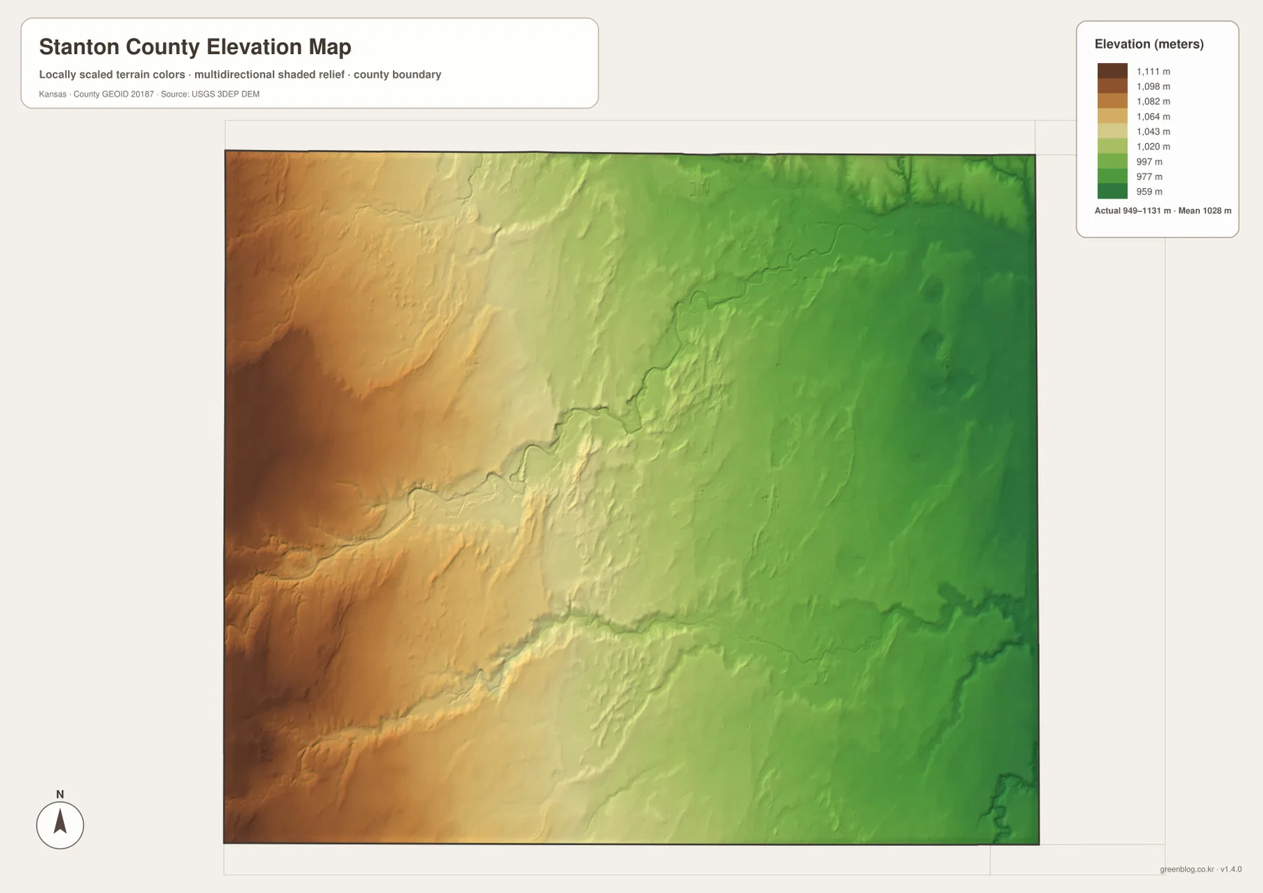
Manter stands on relatively high western plain terrain, while Johnson City lies farther east where the general land surface is lower. Continuing toward Grant County brings another gradual decrease in elevation, even though the landscape remains part of the High Plains rather than changing into a mountain or canyon region.
The elevation surface is generalized for county-scale comparison. It is not survey-grade or engineering-grade measurement and should not be used for parcel elevations, construction grades, drainage design, or legal boundary work.
Dust Bowl history and the Hugoton Gas Field shaped modern Stanton County
The Kansas Historical Society notes that Stanton County was affected by the Dust Bowl during the 1930s. Drought, wind erosion, and major dust storms hit southwestern Kansas especially hard, making the county part of one of the best-known environmental and agricultural crises in Great Plains history.
The same historical source also notes that portions of the Hugoton and Panoma gas fields lie in Stanton County. Natural gas development became an important regional industry beginning in the early twentieth century, while agriculture has remained a central part of the county economy.
US 160 provides a clear cross-section from Manter to Johnson City
Traveling east on US 160 from the Colorado side brings the route through Manter and then toward the K-27 junction beside Johnson City. The road itself is straightforward, but the elevation map shows the subtle descent from higher western uplands toward lower Bear Creek country.
K-27 adds the north–south dimension. North of Johnson City it crosses Bear Creek before entering Hamilton County, while to the south it approaches Sandy Arroyo Creek and continues toward Morton County. Comparing the road, water, and relief views together makes Johnson City’s crossroads location much easier to understand.
For posters, classroom prints, or presentation slides, use the original JPG files in the download archive rather than enlarging the web previews. Small road labels, creek names, town text, and the elevation legend remain clearer at the higher resolution.
Frequently Asked Questions
Why does the city map show only Johnson City and Manter?
The supplied ranked-city dataset contains two entries for Stanton County: Johnson City at 1,549 and Manter at 142. Other small place names can appear on the general map, but only these two incorporated communities are included in the city ranking panel.
Which creek is the strongest water feature on the map?
Bear Creek is the main corridor. It crosses the western and central parts of the county, while Little Bear Creek and Sandy Arroyo Creek form additional valleys through the High Plains.
Can the 949–1,131 meter elevation image be used for surveying?
No. It is a generalized county-scale terrain image for comparing higher western plains with lower creek valleys and eastern ground. Parcel elevations, engineering grades, drainage design, and legal boundary work require more precise official data and, where needed, professional surveying.
Map File Information
The archive contains the Stanton County, Kansas general county map, city map, terrain-and-water map, and elevation map as original high-resolution JPG files.
- Included Files: Use only the versions confirmed in the article and supplied images
- File Type: Use the confirmed download contents
- Intended Use: Printing, education, presentations, and map-based projects
Related Maps
Sources and references
- Stanton County, Kansas official website — county government and Johnson City information
- Kansas Historical Society: Stanton County, Kansas — county seat, High Plains setting, Dust Bowl, Hugoton Gas Field, and local history
- U.S. Census Bureau TIGER/Line Shapefiles — county boundary and geographic reference data
- USGS National Hydrography — creek and drainage reference data
- USGS 3D Elevation Program — elevation and terrain reference data
Green Map creates custom-edited map images using open geographic data sources such as geoBoundaries, Natural Earth, OpenStreetMap, and government open data. These maps are edited visual materials, not raw data files, and are provided for education, documents, presentations, and graphic reference.