Stafford County in south-central Kansas combines small farming communities with one of the state’s most distinctive wetland landscapes. St. John is the county seat, Stafford and Macksville provide important US 50 references, and the northeastern corner opens into the salt marshes of Quivira National Wildlife Refuge. Rattlesnake Creek links the central county with those wetlands, while higher plains dominate the southwest. High-resolution map files are available for download in the section below.
This guide follows St. John, Stafford, Macksville, Hudson, Seward, and Radium across the road, water, and elevation views. Terrain ranges from about 525 to 633 meters. WebP previews are available for quick viewing, and the matching high-resolution JPG files can be downloaded together in one ZIP for printing, classroom work, or offline reference.
Table of Contents
St. John anchors the county while Stafford and Macksville define the US 50 corridor
St. John sits near the middle of Stafford County and serves as the county seat. US 281 provides the strongest north–south reference through the central area, while Stafford and Macksville lie along the east–west US 50 corridor. The towns are separated by long stretches of farmland, so highway and creek locations matter almost as much as community names.
Hudson lies northeast of St. John, while Seward and Radium occupy the northern and northwestern rural area. The map has no continuous urban belt; instead, small settlements are scattered among a dense grid of agricultural roads and several long drainage corridors.
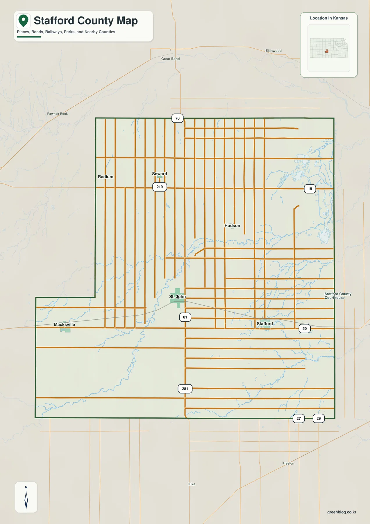
The Kansas Historical Society identifies St. John as the permanent county seat. Its central position and road connections make it the most convenient reference point for comparing the western plains with Stafford and the Quivira wetland country to the east and northeast.
St. John and Stafford lead a widely dispersed six-city index
The city panel ranks St. John at 1,172, Stafford at 809, Macksville at 651, Hudson at 106, Seward at 80, and Radium at 16. These are map index values rather than current official population estimates, but they show a clear hierarchy among the county’s small communities.
The three largest places occupy different parts of the transportation network. St. John serves the central administrative role, Stafford anchors the eastern US 50 side, and Macksville marks the western corridor. Hudson, Seward, and Radium are much smaller rural references in the northern half.
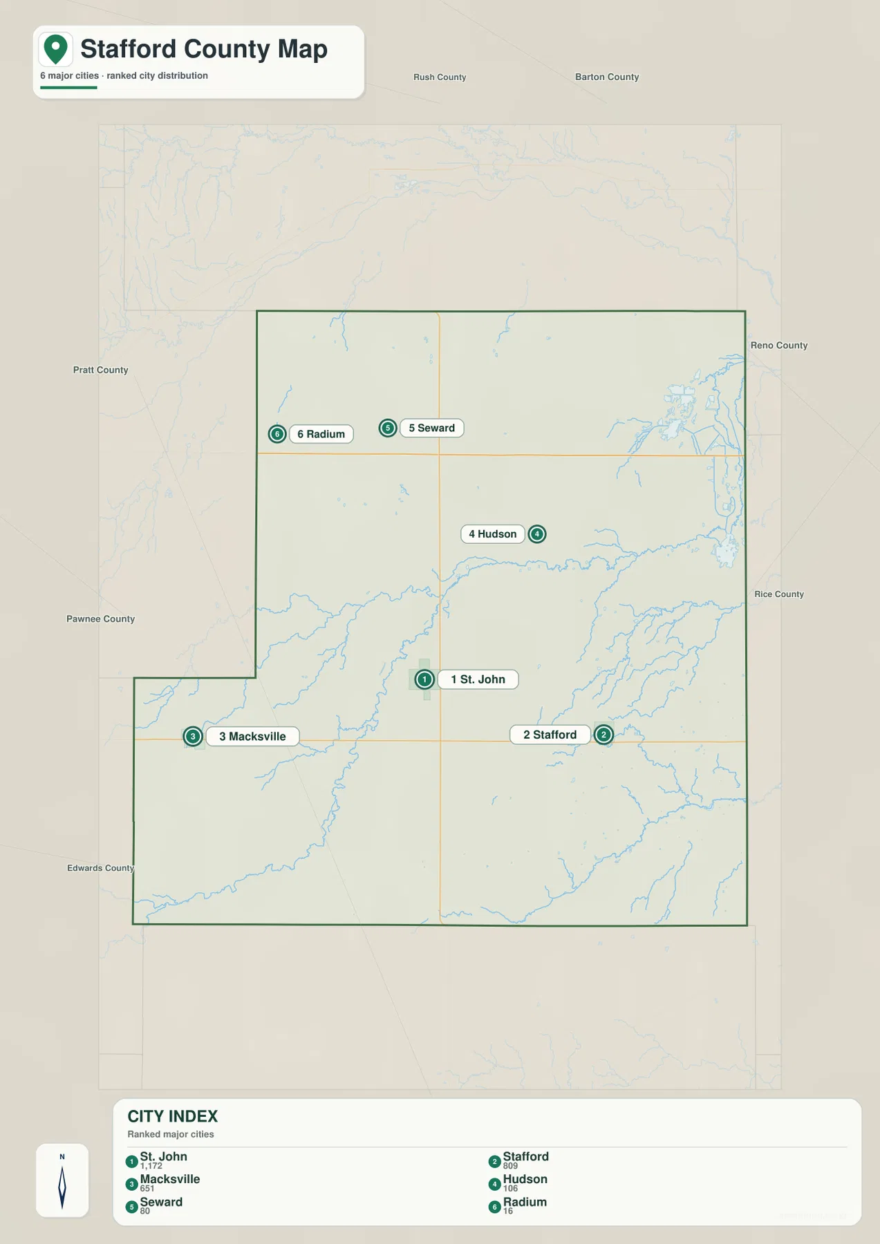
Because all six communities are relatively small, the index is most useful for comparing local settlement scale rather than metropolitan size. Roads, watercourses, and the Quivira wetlands remain essential for understanding where each place sits within the county.
Rattlesnake Creek leads northeast into the Quivira salt marshes
Rattlesnake Creek is the defining watercourse on the Stafford County terrain map. It crosses the central portion of the county and continues northeast into the Quivira National Wildlife Refuge, where a much more complex network of marshes and managed channels appears.
Wild Horse Creek and Bear Creek drain parts of the west, while Spring Creek crosses the south-central area. As the terrain approaches Quivira, Rattlesnake Creek is joined by numerous smaller channels, including mapped canal features associated with wetland water management.
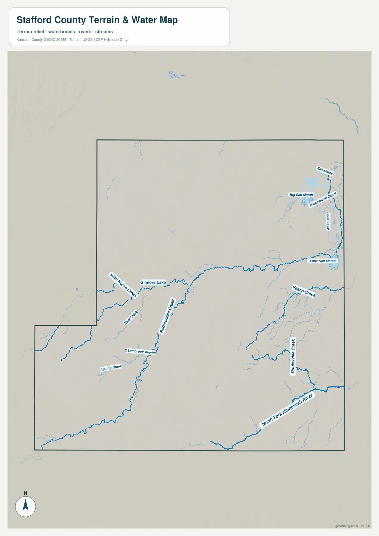
Big Salt Marsh and Little Salt Marsh dominate the northeastern corner. The U.S. Fish and Wildlife Service describes Quivira National Wildlife Refuge as a landscape of inland salt marshes, salt flats, sand prairie, grasslands, stream corridors, and agricultural land that supports major migratory-bird use along the Central Flyway.
The southeastern county has a different drainage setting. The North Fork Ninnescah River and Looperville Creek form lower valleys outside the Quivira marsh system, while Peace Creek crosses the eastern rural area. Stafford County therefore contains both broad salt-wetland country and conventional stream valleys within a relatively compact area.
This water image is intended for geographic reference rather than floodplain, navigation, water-quality, parcel, or legal-access decisions. Marsh and stream conditions can change, so current agency information should be used whenever access or safety matters.
Elevation from 525 to 633 meters falls from the southwest toward Quivira
The elevation surface ranges from about 525 to 633 meters, with a mean near 576 meters. Brown and tan high ground is most extensive in the southwest, while greener lower terrain spreads across the northeast around Rattlesnake Creek and the Quivira marshes.
The Macksville side and the southwestern rural area sit on higher plains cut by narrower stream valleys. Around St. John, terrain is more moderate. From Hudson toward Quivira, the land drops into broader low country associated with Rattlesnake Creek, Big Salt Marsh, and Little Salt Marsh.
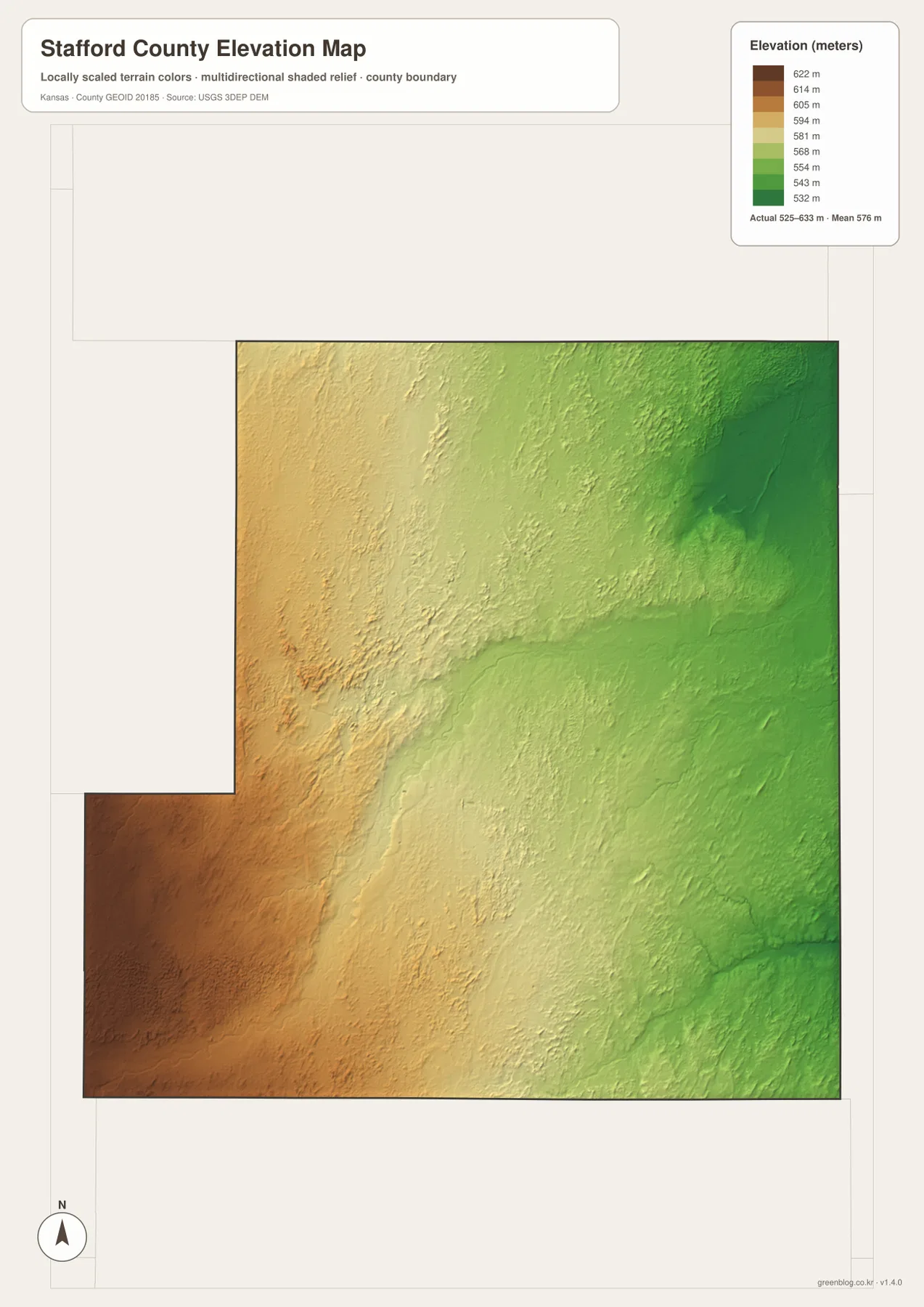
The southeastern North Fork Ninnescah corridor also forms a distinct low band, but the Quivira side is broader and more complicated because shallow marsh basins, stream channels, and managed water features overlap in the same part of the county.
The elevation surface is generalized for county-scale comparison. It is not survey-grade or engineering-grade measurement and should not be used for parcel elevations, construction grades, drainage design, or legal boundary work.
Quivira National Wildlife Refuge makes northeastern Stafford County exceptional
Quivira National Wildlife Refuge occupies much of northeastern Stafford County and extends slightly into neighboring counties. The U.S. Fish and Wildlife Service states that the refuge was established in 1955 and ultimately grew to 22,135 acres, protecting a rare combination of inland salt marsh and sand-prairie habitats.
Big Salt Marsh and Little Salt Marsh have attracted migratory waterfowl for generations. Quivira was designated a Wetland of International Importance in 1992, and the refuge reports more than 340 bird species. The Big Salt Marsh Auto-Tour Road is one of the main ways visitors can experience the wetland landscape.
On the county maps, the refuge is not just a point of interest. Its marsh basins, channels, and low terrain occupy a large section of the northeast, making Quivira one of the most important geographic features for understanding Stafford County as a whole.
St. John became the county seat only after four elections
Stafford County’s county-seat history was unusually complicated. According to the Kansas Historical Society, the first election in 1879 produced no majority. A second vote in 1882 was disrupted when a tornado destroyed a ballot box, and a third election again failed to produce a majority.
A fourth election finally established St. John as the permanent county seat. That history adds context to the modern map: St. John remains near the center of the county, connected by US 281 and a dense farm-road grid, while Stafford and Macksville serve different east–west travel corridors.
Travel from St. John toward Stafford reveals the transition into lower wetland country
Moving east from St. John toward Stafford crosses broad agricultural ground cut by Rattlesnake Creek and smaller tributaries. Continuing northeast from Stafford brings the landscape closer to Quivira, where stream lines become denser and marsh basins replace the simpler upland pattern.
Traveling west from St. John toward Macksville shows the opposite change. Elevation rises, marshes disappear, and smaller creek valleys cut through higher plains. North toward Seward and Radium, settlement density falls and the agricultural road grid becomes the strongest visual reference.
For posters, classroom prints, or presentation slides, use the original JPG files in the download archive rather than enlarging the web previews. Small road labels, creek names, wetland channels, town text, and the elevation legend remain clearer at the higher resolution.
Frequently Asked Questions
Where are Big Salt Marsh and Little Salt Marsh?
Both are in northeastern Stafford County within Quivira National Wildlife Refuge. Big Salt Marsh lies farther north, with Little Salt Marsh to the south, and Rattlesnake Creek plus managed channels connect much of the surrounding wetland area.
Which community is largest on the supplied city index?
St. John ranks first at 1,172, followed by Stafford at 809 and Macksville at 651. Hudson is 106, Seward 80, and Radium 16. These are map index values rather than current official population estimates.
Can the 525–633 meter elevation image be used for surveying?
No. It is a generalized county-scale terrain image for comparing higher southwestern plains with lower creek and marsh country. Parcel elevations, engineering grades, drainage design, and legal boundary work require more precise official data and, where needed, professional surveying.
Map File Information
The archive contains the Stafford County, Kansas general county map, city map, terrain-and-water map, and elevation map as original high-resolution JPG files.
- Included Files: Use only the versions confirmed in the article and supplied images
- File Type: Use the confirmed download contents
- Intended Use: Printing, education, presentations, and map-based projects
Related Maps
Sources and references
- Kansas Historical Society: Stafford County, Kansas — county-seat history, county formation, and local background
- U.S. Fish and Wildlife Service: Quivira National Wildlife Refuge — Big and Little Salt Marsh, refuge size, habitat, and migratory-bird importance
- Stafford County: Quivira National Wildlife Refuge — local refuge location and county visitor information
- U.S. Census Bureau TIGER/Line Shapefiles — county boundary and geographic reference data
- USGS National Hydrography — river and stream reference data
- USGS 3D Elevation Program — elevation and terrain reference data
Green Map creates custom-edited map images using open geographic data sources such as geoBoundaries, Natural Earth, OpenStreetMap, and government open data. These maps are edited visual materials, not raw data files, and are provided for education, documents, presentations, and graphic reference.