Riley County in northeastern Kansas combines a large urban center, a major military installation, a long reservoir shoreline, and deeply cut Flint Hills terrain. Manhattan dominates the southern part of the county, Ogden sits between the city and Fort Riley, and smaller communities such as Riley, Leonardville, and Randolph occupy the northern uplands. The Kansas River forms a broad southern lowland while Tuttle Creek Lake shapes much of the northeastern boundary. High-resolution map files are available for download in the section below.
This guide follows Manhattan and the surrounding communities across the road, water, and relief views, with elevations ranging from about 295 to 463 meters. WebP previews are available for quick viewing, and the matching high-resolution JPG files can be downloaded together in one ZIP for printing, classroom work, or offline reference.
Table of Contents
Manhattan anchors the southern road network beside the Kansas River
Manhattan is the county’s strongest road and settlement reference. K-113 runs along the western side of the city, K-18 continues toward the southeast, and local routes connect westward through Ogden toward Fort Riley. The Kansas River follows the southern side of the urban area, so the relationship between roads, city development, and low river terrain is easy to see.
Riley County’s official website identifies Manhattan as the county seat. On the supplied maps, the city’s large urban footprint and dense road network stand in sharp contrast with the smaller communities and rural roads farther north.
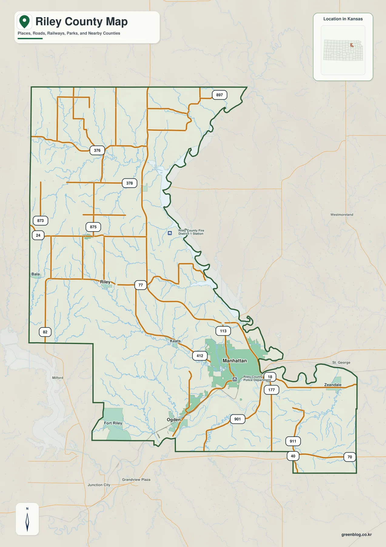
Ogden lies west of Manhattan near Fort Riley, while the city of Riley occupies the west-central interior. Leonardville and Randolph are farther north, where roads are more widely spaced and stream-cut hills replace the broad southern urban lowland.
Manhattan is the clear hub on the city-connections map
The city-connections panel lists Manhattan at 54,239. Ogden is 1,696 and about 8 direct miles away, Riley is 943 and about 15 miles, Leonardville is 514 and about 19 miles, and Randolph is 178 and about 19 miles from the hub.
These are map index values rather than current official population estimates, and the mileages are straight-line distances rather than driving distances. Ogden is closely tied to the Manhattan–Fort Riley corridor, while Riley, Leonardville, and Randolph belong to the much more rural northern half of the county.
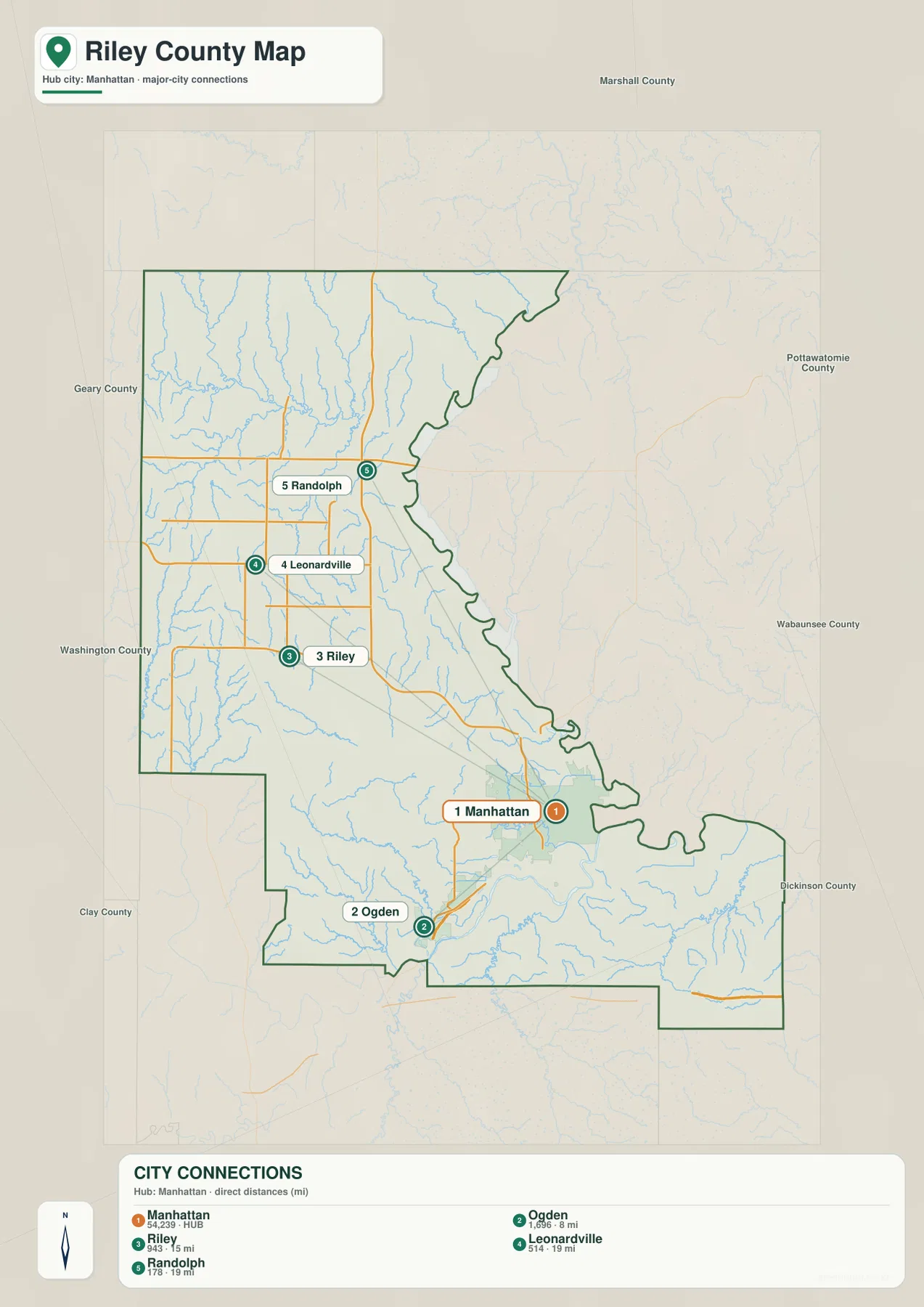
Riley County’s official cities page describes Ogden between Manhattan and Fort Riley and places the city of Riley roughly 20 miles northwest of Manhattan. Those descriptions match the geographic pattern shown on the supplied map.
Tuttle Creek Lake and the Kansas River define the county’s largest low corridors
The water map is dominated by two large features: Tuttle Creek Lake along the northeastern side and the Kansas River through the southern Manhattan area. Between them, numerous creeks descend from higher interior terrain and create long, narrow valleys.
Fancy Creek, Madison Creek, Mill Creek, and North Otter Creek drain the northern uplands toward the Tuttle Creek system. Farther west, Otter Creek and Timber Creek cut long valleys. Wildcat Creek is especially prominent through the central county as it bends southeast toward Manhattan.
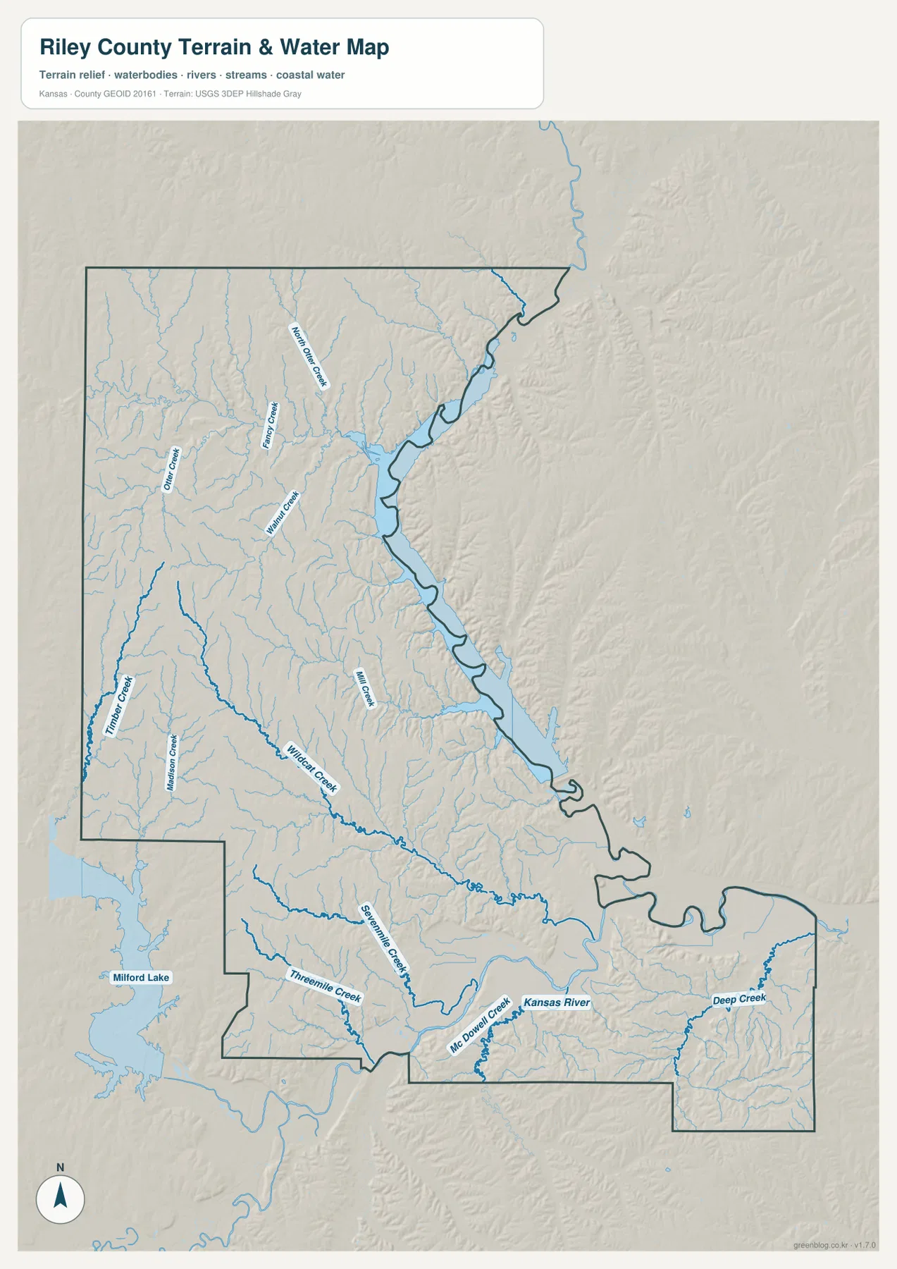
Near Manhattan, Threemile Creek and McDowell Creek form additional low corridors, while Deep Creek drains the southeastern part of the county toward the Kansas River. Milford Lake appears beyond the western edge, but the Tuttle Creek and Kansas River systems are the two strongest water references within Riley County itself.
This water image is intended for geographic reference rather than floodplain, navigation, water-quality, parcel, or legal-access decisions. Water level and stream conditions can change, so current agency information should be used whenever access or safety matters.
Relief from 295 to 463 meters rises quickly away from the main valleys
The elevation surface ranges from about 295 to 463 meters, with a mean near 380 meters. The Kansas River and Tuttle Creek corridors appear as broad green lowlands, while brown and tan hills dominate much of the west and northwest.
Wildcat Creek cuts a deep green path through the central uplands toward Manhattan. The northern half is also dissected by many small tributaries that descend toward Tuttle Creek Lake, creating a much more rugged surface than the road map alone suggests.
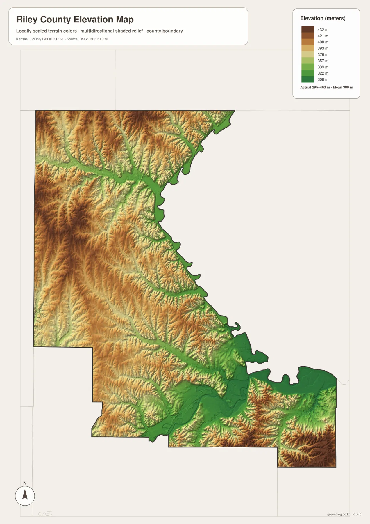
Manhattan occupies low terrain near the Kansas River and several creek valleys. Traveling toward Riley, Leonardville, or the western interior quickly brings the landscape into higher ridges and narrower stream cuts. Randolph lies close to Tuttle Creek Lake, where steep hills meet low reservoir shoreline.
The elevation surface is generalized for county-scale comparison. It is not survey-grade or engineering-grade measurement and should not be used for parcel elevations, construction grades, drainage design, or legal boundary work.
Tuttle Creek State Park gives the northern reservoir landscape a clear local reference
Kansas Department of Wildlife and Parks describes Tuttle Creek State Park near Manhattan as a multi-unit park around the reservoir, including River Pond, Rocky Ford, Cedar Ridge, Fancy Creek, and Randolph areas. The park supports camping, fishing, boating, trails, and other outdoor recreation.
On the county map, Tuttle Creek Lake is more than a single point of interest. Its long shoreline forms a major geographic boundary and helps explain why the Randolph and northern areas contain a mixture of steep hills, creek valleys, and low water edges.
Ogden and Fort Riley form a distinct western edge of the Manhattan area
Ogden lies between Manhattan and Fort Riley, a location also noted on Riley County’s official cities page. The road and rail network around Ogden is directly tied to the Manhattan urban area, but the Fort Riley boundary makes this corridor different from the agricultural communities farther north.
Fort Riley occupies a large area along the southwestern side of the county. The supplied county map is useful for broad location and boundary context, but it is not a guide to installation access or road restrictions. Current Fort Riley information should be used for entry, closures, and travel inside the military area.
North of Manhattan, Riley and Randolph reveal the county’s hillier side
Traveling north from Manhattan leaves the broad Kansas River lowland and enters terrain divided by Wildcat Creek and many smaller tributaries. Riley lies in the west-central part of the county, Leonardville is farther north, and Randolph sits close to the Tuttle Creek system.
The contrast is strongest when the road and elevation views are compared together. Southern Manhattan has dense development and broad low ground, while the northern half contains narrow valleys, higher ridges, and widely spaced small towns. Riley County therefore combines a major urban center with a large rural and reservoir landscape.
For posters, classroom prints, or presentation slides, use the original JPG files in the download archive rather than enlarging the web previews. Small road labels, creek names, town text, and the elevation legend remain clearer at the higher resolution.
Frequently Asked Questions
Which listed city is closest to Manhattan on the city-connections map?
Ogden is shown about 8 direct miles from Manhattan. Riley is about 15 miles away, while Leonardville and Randolph are each about 19 direct miles from the hub. These are straight-line distances rather than driving distances.
Are Tuttle Creek Lake and the Kansas River the same water system?
No. Tuttle Creek Lake follows the northeastern side of the county, while the Kansas River runs along the southern Manhattan area. Numerous creeks drain toward these two major low corridors.
Can the 295–463 meter elevation image be used for surveying?
No. It is a generalized county-scale terrain image for comparing low river and reservoir valleys with higher uplands. Parcel elevations, engineering grades, drainage design, and legal boundary work require more precise official data and, where needed, professional surveying.
Map File Information
The archive contains the Riley County, Kansas general county map, city-connections map, terrain-and-water map, and elevation map as original high-resolution JPG files.
- Included Files: Use only the versions confirmed in the article and supplied images
- File Type: Use the confirmed download contents
- Intended Use: Printing, education, presentations, and map-based projects
Related Maps
Sources and references
- Riley County: City of Manhattan — county seat and Manhattan information
- Riley County: Cities & Townships — Manhattan, Ogden, Riley, Leonardville, and Randolph information
- Kansas Department of Wildlife and Parks: Tuttle Creek State Park — reservoir, park units, and recreation information
- U.S. Census Bureau TIGER/Line Shapefiles — county boundary and geographic reference data
- USGS National Hydrography — river and stream reference data
- USGS 3D Elevation Program — elevation and terrain reference data
Green Map creates custom-edited map images using open geographic data sources such as geoBoundaries, Natural Earth, OpenStreetMap, and government open data. These maps are edited visual materials, not raw data files, and are provided for education, documents, presentations, and graphic reference.