Rice County occupies a central part of Kansas where Lyons and Sterling stand out against a wide rural landscape. US 56 crosses Lyons from west to east, K-14 and K-96 connect the county seat with Sterling, and K-4 serves the northern communities around Bushton and Geneseo. Cow Creek and the Little Arkansas River system add a second layer of geography, cutting broad low corridors through higher agricultural uplands. High-resolution map files are available for download in the section below.
This guide follows Lyons, Sterling, Chase, Little River, Geneseo, and Bushton across the road, water, and relief views. Elevation ranges from about 461 to 565 meters. WebP previews are available for quick viewing, and the matching high-resolution JPG files can be downloaded together in one ZIP for printing, classroom work, or offline reference.
Table of Contents
Lyons provides the clearest road reference in the middle of Rice County
Lyons sits near the county center on US 56, which provides the strongest east–west route across Rice County. K-14 and K-96 run south from the Lyons area toward Sterling, while K-46 extends east toward Little River. In the north, K-4 passes near Bushton and Geneseo, creating a separate east–west route for the northern part of the county.
The Kansas Historical Society identifies Lyons as the Rice County seat and explains that voters selected a centrally located county seat in 1876. The present map fits that history well: Lyons sits close to the middle of the county where highways, rail lines, and local roads converge.
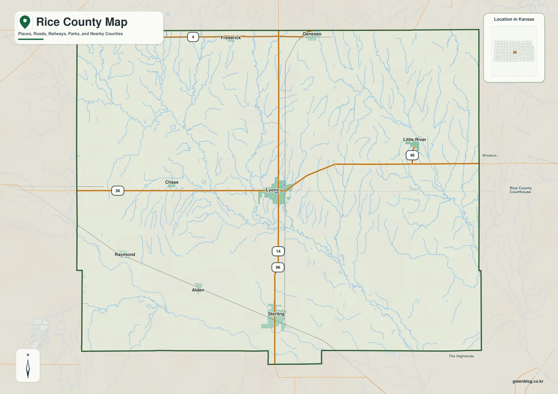
Chase lies west of Lyons near US 56, while Little River sits farther east near K-46. Sterling is close to the southern county edge along the K-14 and K-96 corridor. Raymond and Alden provide smaller references in the southwest, showing that the county’s communities are spread among several different road corridors rather than concentrated in one strip.
Lyons and Sterling dominate the six-city index
The city panel ranks Lyons at 3,553 and Sterling at 2,411. Chase follows at 490, Little River at 402, Geneseo at 213, and Bushton at 201. These are map index values rather than current official population estimates, but they explain the much larger markers for Lyons and Sterling.
The two largest cities occupy a north–south relationship in the central and southern county, while the smaller towns spread in several directions. Chase and Little River sit to the west and east of Lyons, and Geneseo and Bushton belong to the northern K-4 corridor. That distribution gives Rice County two larger service centers and several smaller agricultural communities.
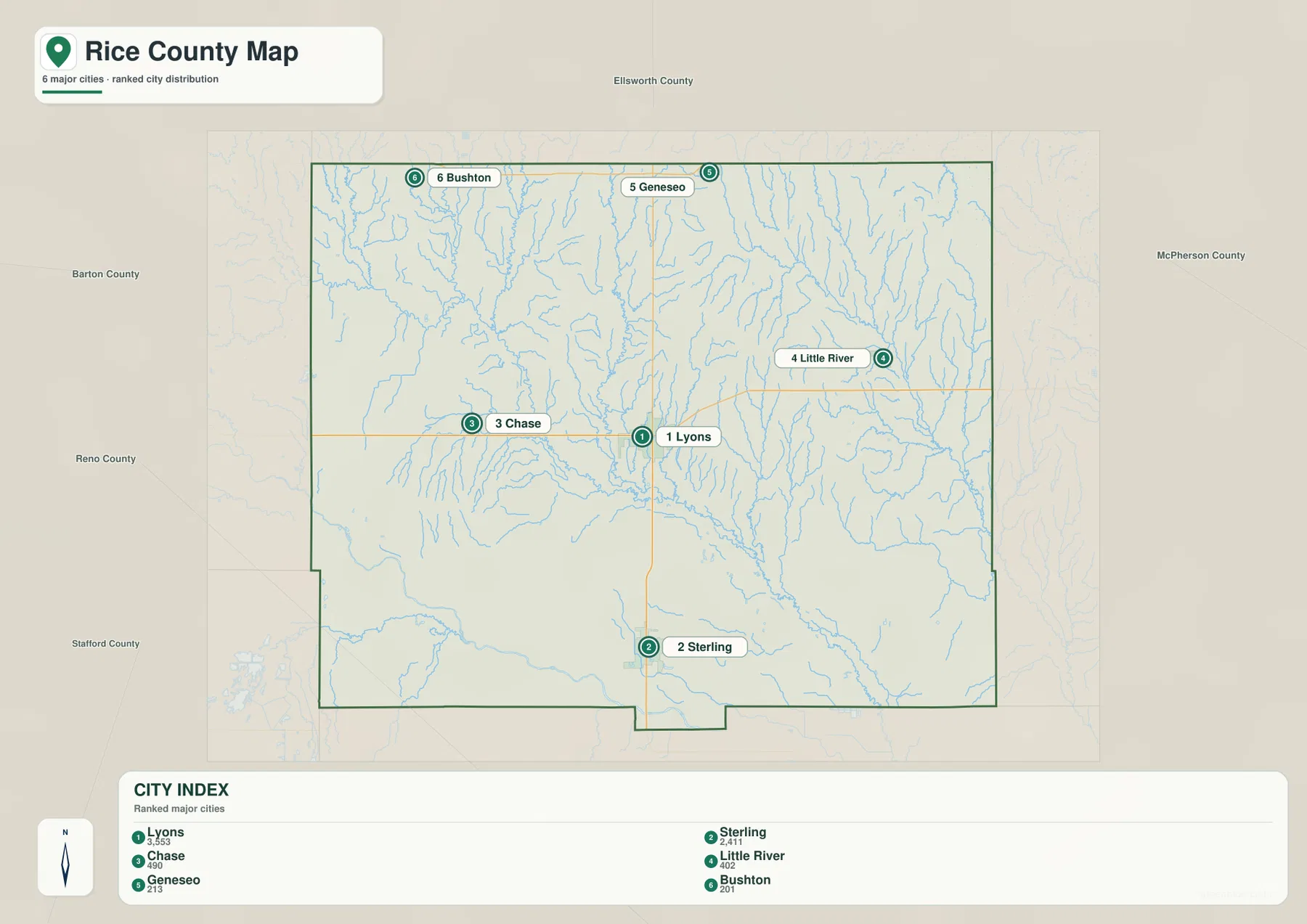
Kansas Historical Society census information also lists Lyons and Sterling as the county’s two largest cities. The census figures and the supplied map index are different datasets and should not be treated as interchangeable, but both show the same broad settlement pattern.
Cow Creek and the Little Arkansas River create separate low corridors
Cow Creek is the strongest central drainage on the water map. It enters from the west, gathers numerous short tributaries, and continues toward the southeast. Little Cow Creek creates another long valley farther north, while Spring Creek and Lost Creek descend from the western uplands toward the larger drainage network.
The Little Arkansas River dominates the northeastern and eastern side. Near the eastern boundary, the North Fork Little Arkansas River forms another major channel. Numerous tributaries feed these valleys, which makes the eastern county appear much more finely divided than the broad western uplands.
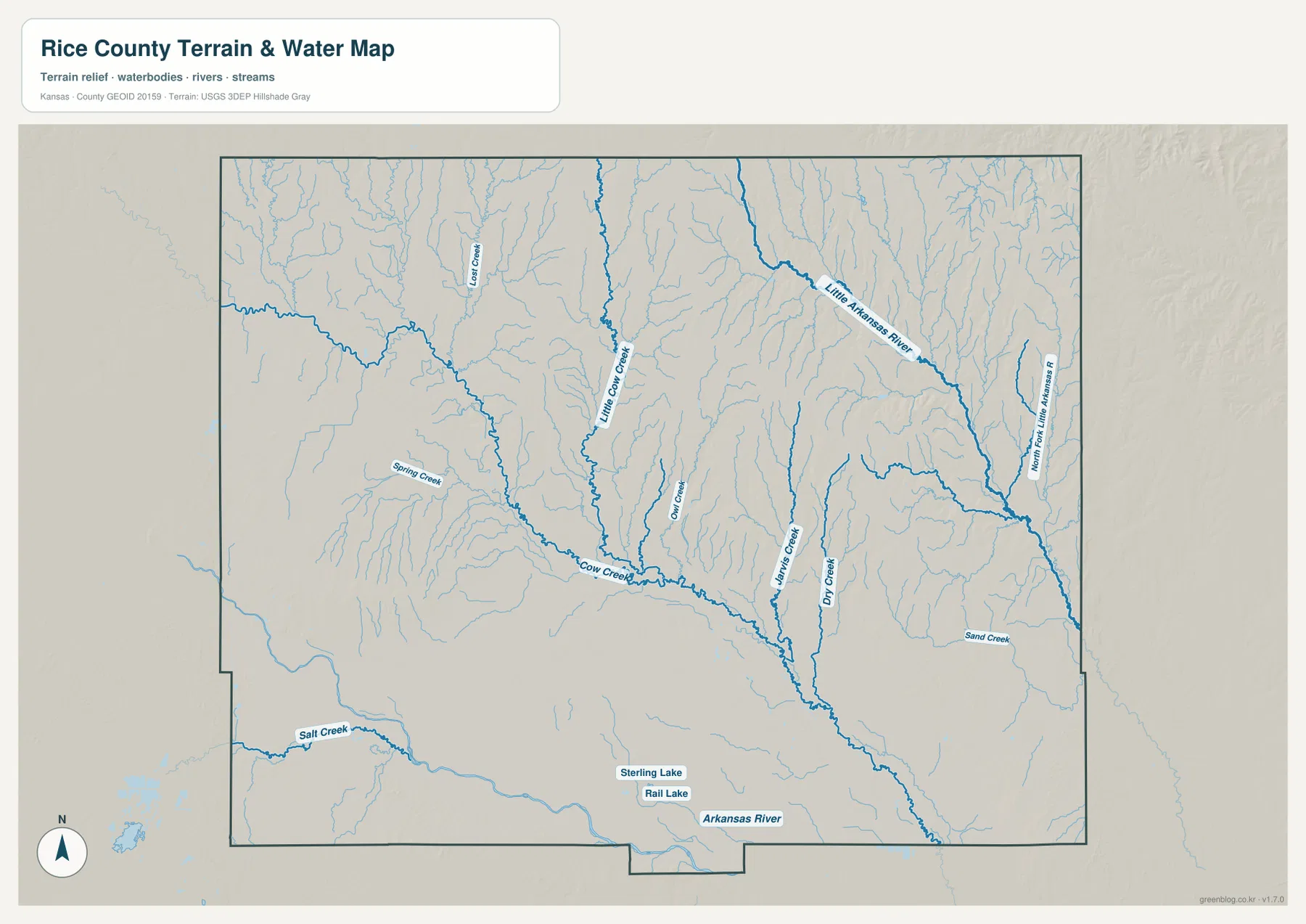
Owl Creek, Willis Creek, and Dry Creek cut the central-eastern uplands between the larger channels, and Sand Creek appears farther southeast. Salt Creek forms a separate valley in the southwest. Sterling Lake and Rail Lake provide smaller local water references near Sterling.
The Arkansas River appears along part of the southern edge of the county. It is separate from the central Cow Creek drainage and the Little Arkansas River system to the east, so it provides another useful reference for the lowest southern terrain.
This water image is intended for geographic reference rather than floodplain, navigation, water-quality, parcel, or legal-access decisions. Stream flow and lake conditions can change, so current agency information should be used whenever access or safety matters.
Relief from 461 to 565 meters drops toward the eastern stream valleys
The elevation surface ranges from about 461 to 565 meters, with a mean near 515 meters. The highest brown and tan terrain is concentrated in the northwest and north-central portions of the county. Green lowlands become much more extensive toward the east and southeast, where the larger drainage systems cut through the landscape.
Cow Creek forms a lower corridor across the middle and southeast, while the Little Arkansas River and its North Fork create broader green valleys near the eastern side. Around Chase and Bushton, higher ground occupies more of the map and the smaller creeks cut narrower channels through it.
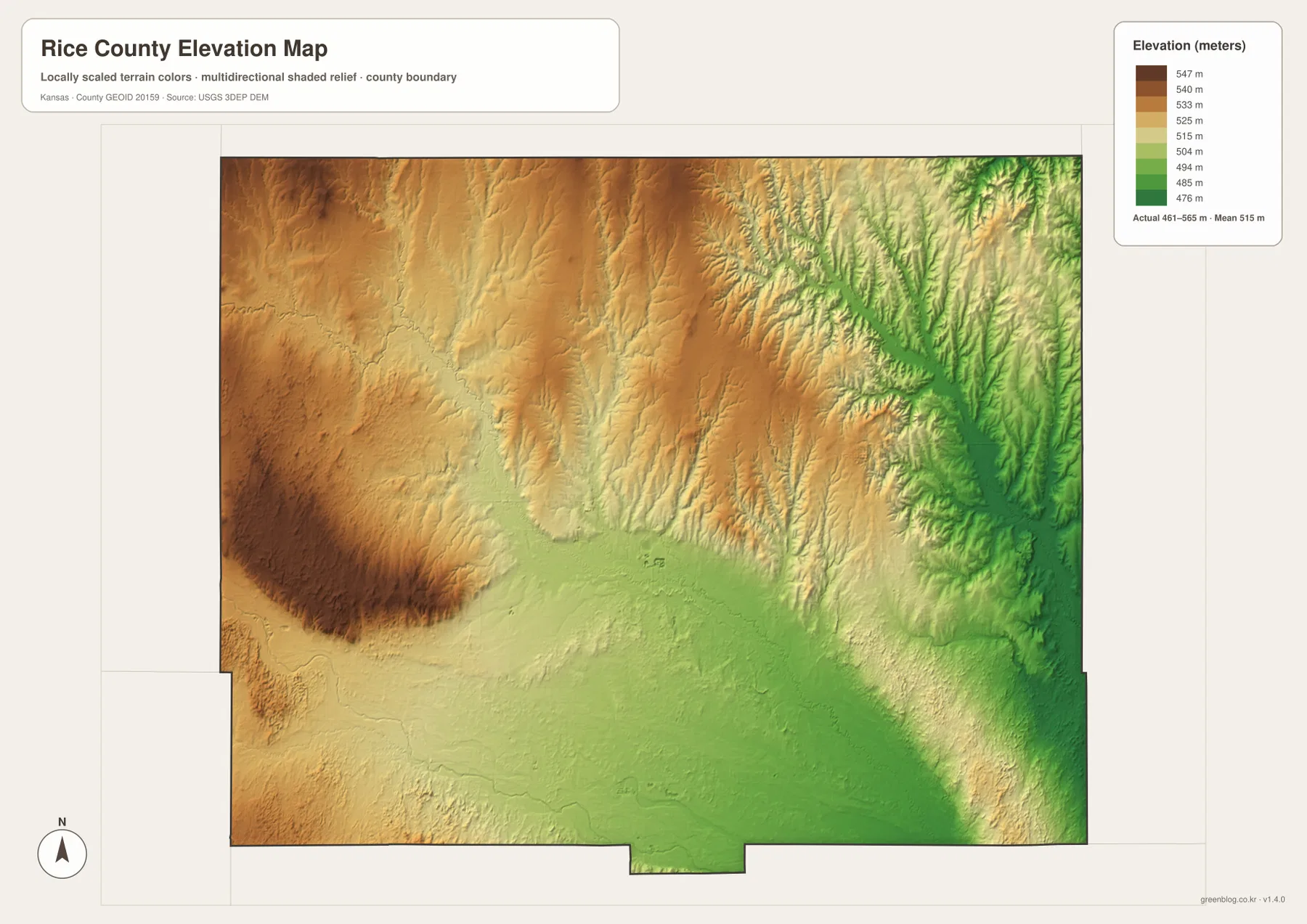
Sterling and the southern edge lie in generally lower terrain than the north-central uplands, with the Arkansas River marking another low corridor along the bottom of the county. The Geneseo side combines higher rolling ground with many narrow tributary valleys, so even the northern plateau is not completely uniform.
The elevation surface is generalized for county-scale comparison. It is not survey-grade or engineering-grade measurement and should not be used for parcel elevations, construction grades, drainage design, or legal boundary work.
Santa Fe Trail history and Quivira give the Lyons area a distinctive local story
The Kansas Historical Society notes that the Santa Fe Trail passed through Rice County. A state historical marker titled “The Land of Quivira” stands along US 56 about three miles west of Lyons and explains the local connection with Francisco Vásquez de Coronado’s 1541 journey and the Wichita villages he encountered in the region.
The same county history describes Plum Buttes, a group of sand dunes that once served as a prominent Santa Fe Trail landmark after travelers crossed Cow Creek. The dunes later eroded, but the story provides useful context for the road and water features west of Lyons: this area has long been shaped by movement across the prairie and by access to creek crossings.
Sterling provides a second urban center in the lower southern terrain
Sterling sits south of Lyons along the K-14 and K-96 corridor and ranks second on the supplied city index. Sterling Lake and Rail Lake appear nearby, while the terrain gradually lowers toward the southern edge and the Arkansas River. The city therefore provides a useful contrast with the higher northern parts of the county.
The Kansas Historical Society records that Cooper College opened in Sterling in 1886 and later became Sterling College. That history helps explain why Sterling has remained an important community even though Lyons is the county seat and the largest city marker.
Following the county from Chase through Lyons to Little River shows the west-to-east terrain change
US 56 provides a useful cross-section from Chase toward Lyons. The western side begins in higher ground, while the route approaches lower Cow Creek country near the county center. Continuing toward Little River brings the map into a denser network of streams associated with the Little Arkansas River system.
A north–south comparison is just as useful. Bushton and Geneseo lie among higher uplands and narrow tributaries, while Sterling occupies lower southern terrain. Following these corridors makes the relationship between roads, streams, and elevation easier to understand than treating each map as an isolated layer.
For posters, classroom prints, or presentation slides, use the original JPG files in the download archive rather than enlarging the web previews. Small road labels, creek names, town text, and the elevation legend remain clearer at the higher resolution.
Frequently Asked Questions
Which city is largest on the supplied city index?
Lyons ranks first at 3,553 and Sterling second at 2,411. Chase is 490, Little River 402, Geneseo 213, and Bushton 201. These are map index values rather than current official population estimates.
Are Cow Creek and the Little Arkansas River the same waterway?
No. Cow Creek crosses the central part of Rice County and continues toward the southeast, while the Little Arkansas River and its North Fork occupy separate major valleys in the northeastern and eastern parts of the county.
Can the 461–565 meter elevation image be used for surveying?
No. It is a generalized county-scale terrain image for comparing higher uplands with lower river and creek valleys. Parcel elevations, engineering grades, drainage design, and legal boundary work require more precise official data and, where needed, professional surveying.
Map File Information
The archive contains the Rice County, Kansas general county map, city map, terrain-and-water map, and elevation map as original high-resolution JPG files.
- Included Files: Use only the versions confirmed in the article and supplied images
- File Type: Use the confirmed download contents
- Intended Use: Printing, education, presentations, and map-based projects
Related Maps
Sources and references
- Kansas Historical Society: Rice County, Kansas — county seat, Santa Fe Trail, Quivira, local history, and regional geography
- Kansas Historical Society: The Land of Quivira marker — US 56 historical marker west of Lyons
- U.S. Census Bureau TIGER/Line Shapefiles — county boundary and geographic reference data
- USGS National Hydrography — river and stream reference data
- USGS 3D Elevation Program — elevation and terrain reference data
Green Map creates custom-edited map images using open geographic data sources such as geoBoundaries, Natural Earth, OpenStreetMap, and government open data. These maps are edited visual materials, not raw data files, and are provided for education, documents, presentations, and graphic reference.