Republic County lies along the Nebraska line in north-central Kansas, with Belleville serving as the main road and county-service center. US 36 crosses the county through Scandia, Belleville, and Cuba, while US 81 runs north–south through Belleville. Farther west, the Republican River occupies a broad low valley, and the interior is cut by numerous smaller creeks that make the terrain more varied than a simple road map suggests. High-resolution map files are available for download in the section below.
This guide follows Belleville, Scandia, Cuba, Courtland, Munden, and Republic across the road, water, and relief views. Elevation ranges from about 403 to 515 meters. WebP previews are available for quick viewing, and the matching high-resolution JPG files can be downloaded together in one ZIP for printing, classroom work, or offline reference.
Table of Contents
Belleville anchors the county at the US 36 and US 81 crossroads
Belleville sits near the middle of Republic County where US 36 and US 81 meet. US 36 provides the clearest east–west reference, connecting Scandia on the west side with Cuba farther east. US 81 crosses the county from the Nebraska line through Belleville and continues south toward Cloud County.
The Kansas Historical Society identifies Belleville as the Republic County seat. The general map supports that role visually because the town sits where the two principal highways, rail lines, and several local roads converge. Cuba and Scandia are especially easy to place because both follow the same US 36 corridor on opposite sides of Belleville.
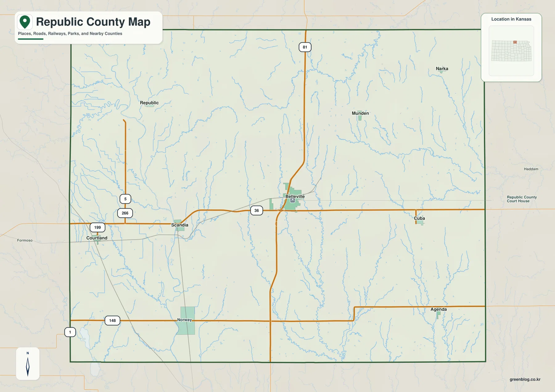
K-148 crosses the southern part of the county near Norway and Agenda, while the Courtland side contains additional state and local road connections. Near the Republic community, K-266 provides the important approach toward the Pawnee Indian Museum, linking the road map with one of the county’s most significant historic sites.
Belleville leads the city index, followed by five much smaller communities
The city panel ranks Belleville at 2,086. Scandia follows at 288, Cuba at 192, Courtland at 163, Munden at 158, and Republic at 148. These are map index values rather than current official population estimates, but they explain the strong difference in marker size between Belleville and the other communities.
The towns are also spread across several distinct parts of the county. Belleville, Scandia, and Cuba follow the central US 36 corridor. Courtland lies near the western edge, Munden occupies the northeastern side, and Republic sits in the northwest. That arrangement gives the county several small rural service points around one dominant center.
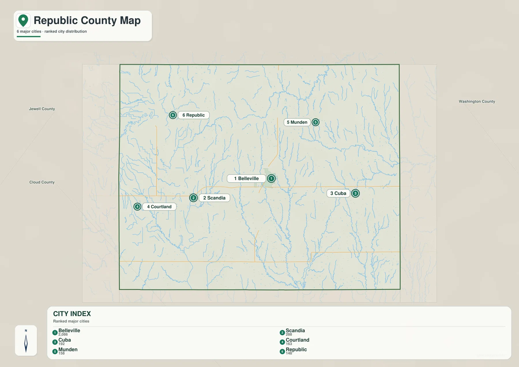
Kansas Historical Society census information also lists Belleville as the county’s largest city. The census counts and the supplied map index are different datasets and should not be treated as interchangeable, but both reflect the same broad settlement hierarchy.
The Republican River creates the county’s broad western lowland
The Republican River is the strongest single water feature on the terrain map. It follows the western side of the county in a broad winding valley, shaping the landscape around the Scandia and Courtland area. The Kansas Historical Society notes that Republic County was named for the Republican River, tying the county name directly to this western drainage.
Beaver Creek forms another long valley near the western side and approaches the Republican River system. Sportsmans Lake appears near the southwestern edge. Together, the large river, Beaver Creek, and smaller tributaries create much wider lowlands than the narrow creek valleys found across the interior.
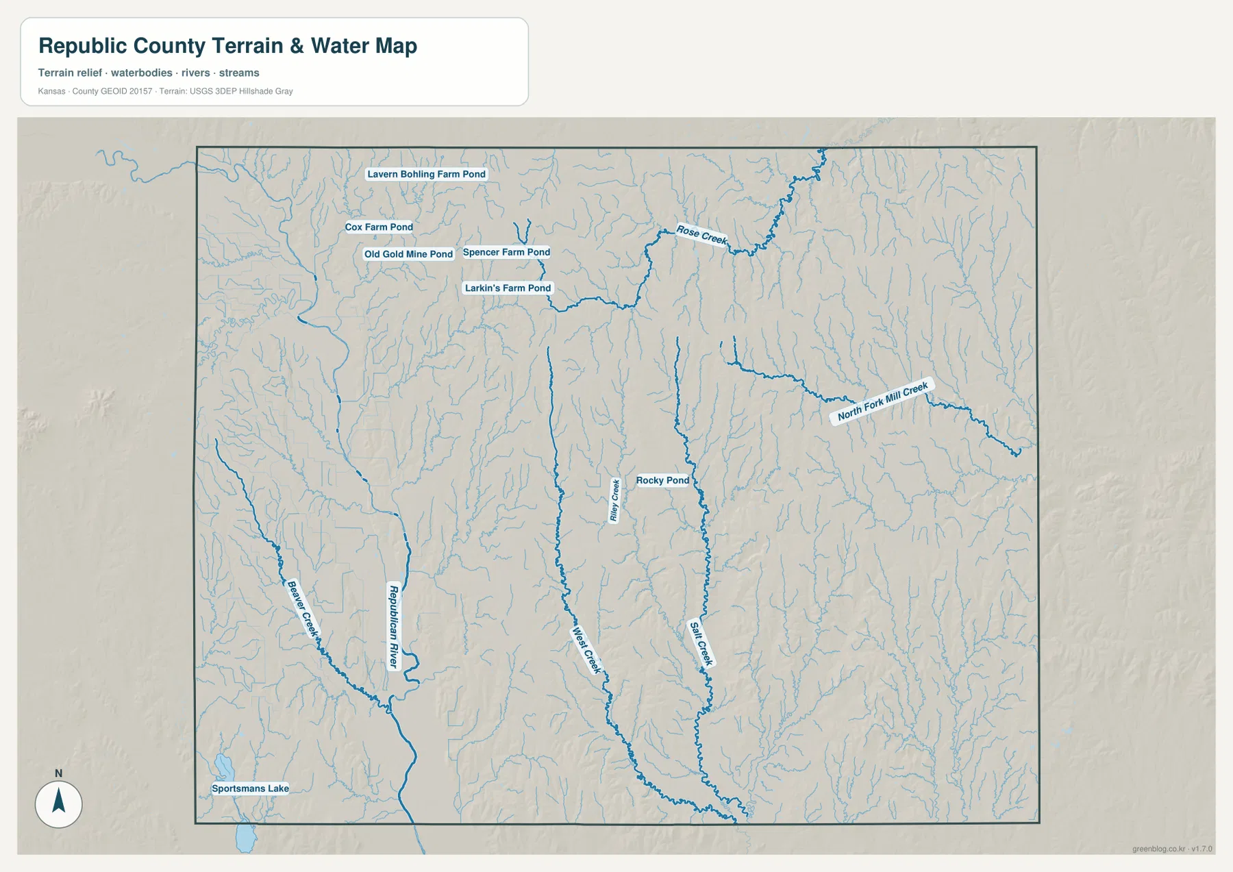
West Creek and Salt Creek form long north–south valleys through the central part of the county. Riley Creek passes near Rocky Pond, Rose Creek cuts through the northern and northeastern hills, and North Fork Mill Creek creates another long drainage corridor on the eastern side. The resulting pattern is a broad river lowland in the west and a dense network of narrower valleys farther east.
Several small farm ponds are labeled in the northwest, including Lavern Bohling Farm Pond, Cox Farm Pond, Old Gold Mine Pond, Spencer Farm Pond, and Larkin’s Farm Pond. They are much smaller than the Republican River, but they show how water storage is distributed across the higher agricultural terrain.
This water image is intended for geographic reference rather than floodplain, navigation, water-quality, parcel, or legal-access decisions. Water level and stream conditions can change, so current agency information should be used whenever access or safety matters.
Relief from 403 to 515 meters separates the Republican River valley from northern uplands
The elevation surface ranges from about 403 to 515 meters, with a mean near 464 meters. The Republican River valley appears as a broad green low corridor in the west, while brown and tan uplands are most extensive across the north-central portion of the county. Eastern Republic County is more finely dissected by long green creek valleys.
The difference between the river valley and the interior hills is one of the clearest features on the map. Low ground along the Republican River is wide and relatively continuous, while tributaries farther east cut narrow channels into higher land. Belleville and Munden lie closer to the rolling interior uplands than Courtland and Scandia do.
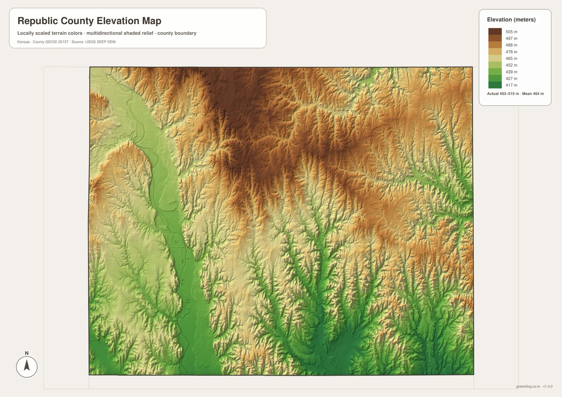
Toward the south, West Creek and Salt Creek create wider green corridors, and the southeastern part contains many closely spaced tributary valleys. The north-central upland remains higher and more continuous, giving the county a strong contrast between elevated interior ground and lower drainage routes.
The elevation surface is generalized for county-scale comparison. It is not survey-grade or engineering-grade measurement and should not be used for parcel elevations, construction grades, drainage design, or legal boundary work.
Pawnee Indian Museum connects the Republic community with the Republican River valley
Pawnee Indian Museum State Historic Site is one of Republic County’s most distinctive historic places. The Kansas Historical Society explains that a Kitkahahki, or Republican band, Pawnee village stood in this part of the Republican River valley beginning in the 1770s.
The museum is near the community of Republic, about eight miles north of US 36 on K-266. The site preserves the excavated floor of a large earth lodge along with lodge depressions, storage-pit evidence, artifacts, and interpretive exhibits. Its location provides a direct connection between the county’s road map, the Republican River landscape, and the history behind the county name.
Kansas Historical Society material describes the village as home to roughly 2,000 Pawnees at one point. Because hours and seasonal operations can change, current museum information should be checked before an in-person visit.
Scandia and Courtland are closely tied to the Republican River lowland
Following US 36 west from Belleville toward Scandia brings the road closer to the broad Republican River valley. Courtland lies farther west in the same general lowland setting, where the large river and several tributaries occupy much more space than the narrow interior creeks.
The elevation image makes the contrast especially clear. The western river corridor stays low and green, while higher ground rises quickly to the east and northeast. Using the river as the first reference makes the roads, towns, and smaller tributaries around Scandia and Courtland easier to place.
East of Belleville, Cuba and Munden sit among denser creek valleys
Traveling east from Belleville toward Cuba means moving away from the broad Republican River valley and into terrain divided by many smaller streams. North Fork Mill Creek and numerous tributaries cut the eastern hills, while the Munden side is influenced by Rose Creek and a dense network of shorter channels.
The relief map shows the same transition. High north-central ground remains between the valleys, but lower green corridors become more frequent near the eastern boundary. Comparing the US 36 corridor from Scandia through Belleville to Cuba therefore provides a useful cross-section of Republic County’s western river lowland and eastern dissected uplands.
For posters, classroom prints, or presentation slides, use the original JPG files in the download archive rather than enlarging the web previews. Small road labels, creek names, town text, and the elevation legend remain clearer at the higher resolution.
Frequently Asked Questions
Which city is largest on the supplied city index?
Belleville ranks first at 2,086. Scandia is 288, Cuba 192, Courtland 163, Munden 158, and Republic 148. These are map index values rather than current official population estimates.
Where does the Republican River run through the county?
The Republican River follows the western side of Republic County and creates the broad lowland around the Scandia and Courtland area. Central and eastern parts of the county are divided by smaller waterways such as West Creek, Salt Creek, Rose Creek, and North Fork Mill Creek.
Can the 403–515 meter elevation image be used for surveying?
No. It is a generalized county-scale terrain image for comparing lower river and creek valleys with higher uplands. Parcel elevations, engineering grades, drainage design, and legal boundary work require more precise official data and, where needed, professional surveying.
Map File Information
The archive contains the Republic County, Kansas general county map, city map, terrain-and-water map, and elevation map as original high-resolution JPG files.
- Included Files: Use only the versions confirmed in the article and supplied images
- File Type: Use the confirmed download contents
- Intended Use: Printing, education, presentations, and map-based projects
Related Maps
Sources and references
- Kansas Historical Society: Republic County, Kansas — county seat, Republican River, county history, and population information
- Kansas Historical Society: Pawnee Indian Museum — museum location, K-266 approach, exhibits, and visitor information
- Pawnee Indian Museum State Historic Site — Kitkahahki Pawnee village and Republican River valley history
- U.S. Census Bureau TIGER/Line Shapefiles — county boundary and geographic reference data
- USGS National Hydrography — river and stream reference data
- USGS 3D Elevation Program — elevation and terrain reference data
Green Map creates custom-edited map images using open geographic data sources such as geoBoundaries, Natural Earth, OpenStreetMap, and government open data. These maps are edited visual materials, not raw data files, and are provided for education, documents, presentations, and graphic reference.