Leavenworth County sits on the Missouri River at the northeastern edge of Kansas. Leavenworth is both the county seat and the largest city, with Lansing immediately to the south. Basehor and Tonganoxie are the main centers farther south and west, while Linwood and Easton provide smaller rural references. The downloadable ZIP on this page contains high-resolution JPG files for the county, city, water, and elevation maps.
The county is much hillier than a road map alone suggests. The Missouri River forms the eastern edge, the Kansas River follows the south, and Stranger Creek cuts a long valley through the western interior. Little Stranger Creek, Tonganoxie Creek, Nine Mile Creek, Wolf Creek, and several shorter streams add more valleys between the ridges. Elevation ranges from about 226 to 354 meters, with the lowest ground along the major rivers.
Leavenworth County is also closely tied to early Kansas history. Fort Leavenworth was founded above the Missouri River in 1827, and the county was established in 1855. The modern map still shows the relationship between that old river-and-fort center in the northeast and the more rural hills around Tonganoxie, Easton, and the western part of the county.
Table of Contents
Leavenworth and Lansing share the Missouri River side
Leavenworth occupies the northeastern corner of the county just west of the Missouri River. U.S. 73 and K-7 run through the Leavenworth–Lansing area, while K-92 heads west from Leavenworth into the rural interior. Lansing begins immediately south of Leavenworth, so the two cities appear almost continuous on the general map even though they are separate municipalities.
Basehor and Tonganoxie lie farther south. Basehor is closer to the Kansas City suburban edge, while Tonganoxie sits among more open hills and farmland. Linwood is near the Kansas River along the southern boundary, and Easton provides a useful reference for the northwestern countryside.
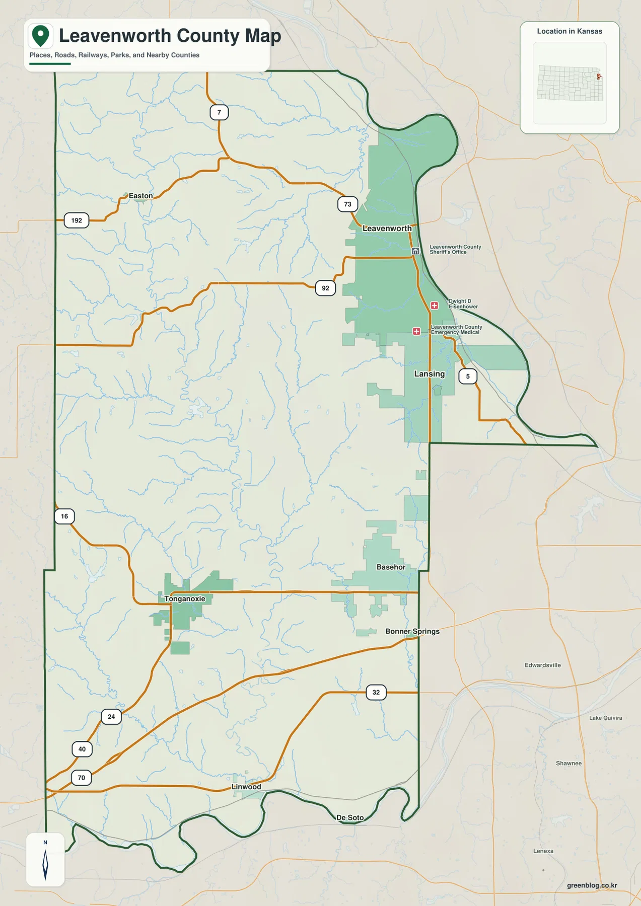
U.S. 24/40 and I-70 cross the southern part of the county, and K-32 connects the Basehor side with nearby Kansas City-area communities. K-16 and K-192 are useful references near Easton. For actual driving, current traffic, construction, winter weather, and flood-related closures should be checked separately.
Leavenworth is the largest city, followed by Lansing and Basehor
The city map ranks Leavenworth first, Lansing second, Basehor third, Tonganoxie fourth, Linwood fifth, and Easton sixth. The mapped source values are 37,195 for Leavenworth, 11,246 for Lansing, 7,491 for Basehor, 5,891 for Tonganoxie, 312 for Linwood, and 299 for Easton. Population figures can change with the source year, but the overall distribution is easy to see.
Most of the larger population centers are on the eastern and southern side of the county. Leavenworth and Lansing form the strongest urban concentration near the Missouri River, Basehor reflects the suburban growth closer to Kansas City, and Tonganoxie serves a more rural western area.
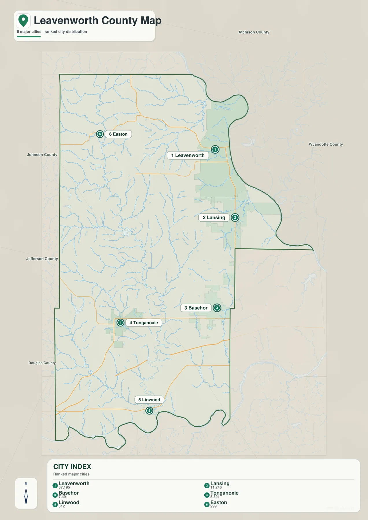
Leavenworth is also the county seat, so population and county government are concentrated in the same city. Lansing developed separately just to the south, while Basehor has grown more recently as the Kansas City metropolitan area expanded westward.
Missouri River, Stranger Creek, and the smaller valleys
The Missouri River is the largest water feature touching Leavenworth County. It follows the eastern boundary in broad bends, with Leavenworth and Lansing sitting on higher ground to the west. Seven Mile Creek and several short tributaries descend toward the river, and Salt Creek drains part of the northern county.
Stranger Creek is the main stream through the interior. It begins in the northwest, runs through a long valley, and continues south toward the Kansas River. Little Stranger Creek joins it in the central county. Tonganoxie Creek crosses the southwest, while Nine Mile Creek and Wolf Creek create additional valleys near the southern side.
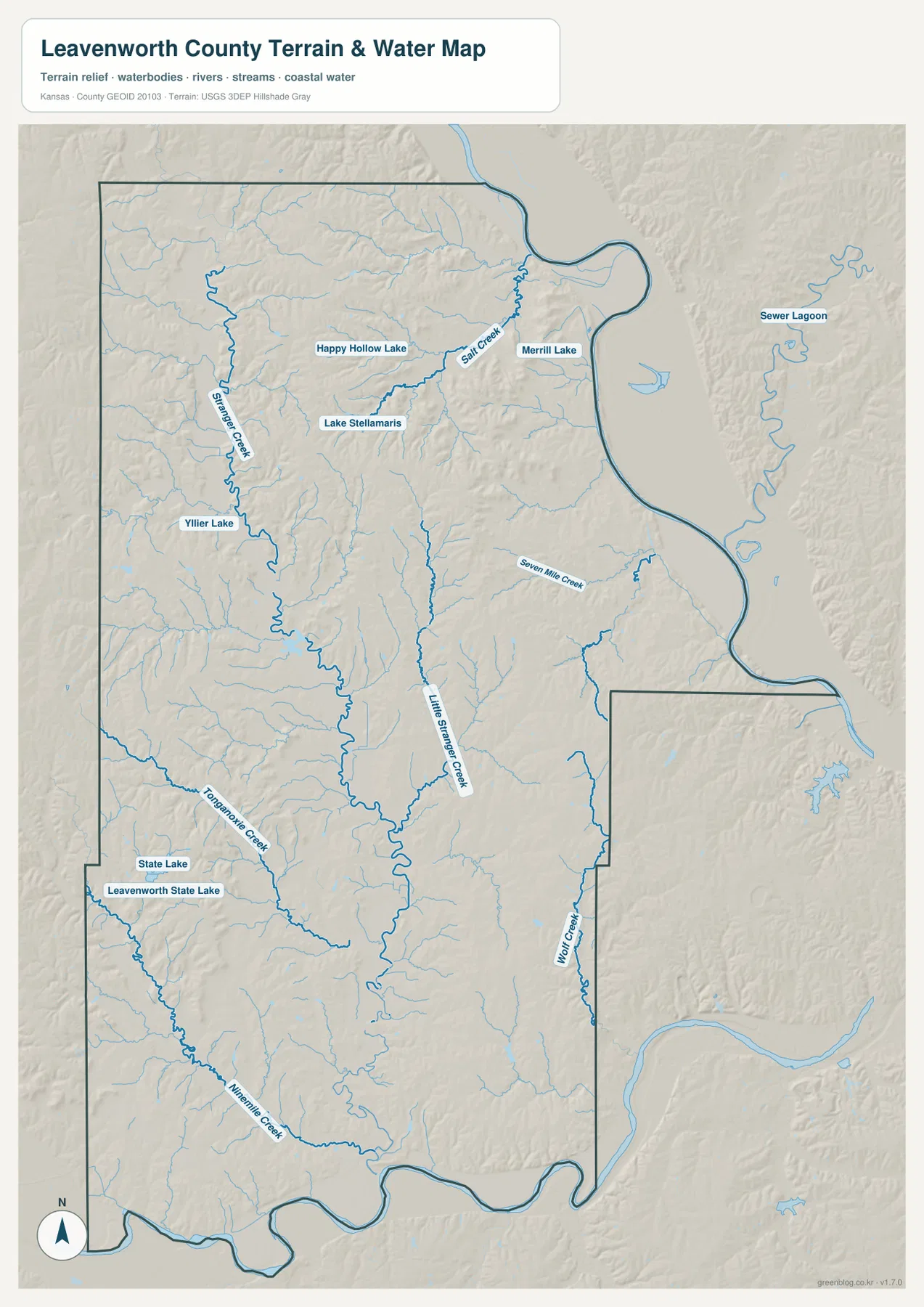
Leavenworth State Lake and State Lake are useful references in the southwest. Happy Hollow Lake, Lake Stellamaris, and Merrill Lake appear farther north. These features help explain the shape of the terrain, but the map is not intended to show live river levels, flood risk, or water quality.
River bottoms sit far below the western ridges
Elevation in Leavenworth County ranges from roughly 226 to 354 meters, with a mean near 285 meters. The Missouri River and Kansas River bottoms are the lowest areas, shown in green on the elevation map. Higher ridges appear across the west and northwest in tan, orange, and brown.
Stranger Creek creates a long lower valley through those western hills. Little Stranger Creek and Tonganoxie Creek cut additional channels between the ridges. Even near Leavenworth and Lansing, the land rises quickly once it leaves the river edge, so the eastern side is not simply one flat floodplain.
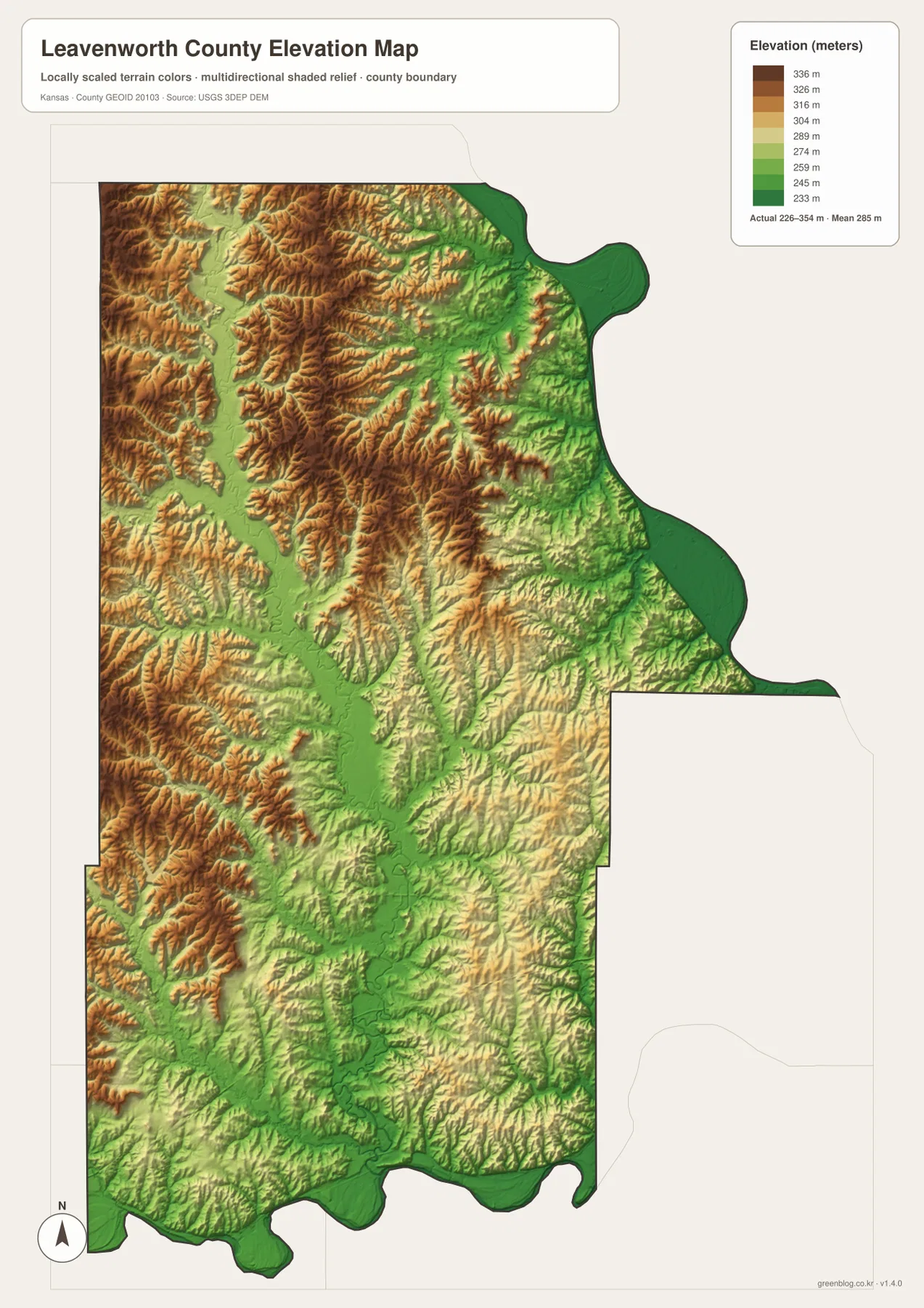
This map is useful for county-scale comparison, not for survey work. Exact parcel elevations, construction planning, drainage design, and legal boundary work require more detailed sources and professional measurement.
Fort Leavenworth grew above the Missouri River
Fort Leavenworth began in 1827 when Colonel Henry Leavenworth established a military post on high ground above the Missouri River. The U.S. Army describes the post as one of the oldest continuously active military installations west of Washington, D.C. Early missions included frontier defense, support for western travelers, and logistics for military expeditions.
Its location makes sense on the map. High ground above a major river provided a useful place to watch movement and still remain close to an important transportation route. The city of Leavenworth later grew immediately south of the fort and became the county’s administrative and commercial center.
The county itself was established in 1855 and took Henry Leavenworth’s name. Kansas Historical Society records also note Abraham Lincoln’s 1859 visit to Kansas Territory, during which he spoke in Leavenworth.
A Missouri border county during Bleeding Kansas
The Missouri River border placed Leavenworth County directly inside the political conflict known as Bleeding Kansas. People crossed the border during elections and political disputes over whether Kansas would enter the Union as a free or slave state.
The county-seat question was also contested in the early years. Leavenworth competed with other places, and disputed election results became part of the process before the city secured the county-seat role. County government has remained there ever since.
The modern map cannot show those political conflicts, but it makes the underlying geography obvious. Missouri is just across the river, Fort Leavenworth occupies the northeastern high ground, and the oldest urban development grew around the same river corridor.
Tonganoxie and Linwood show a different side of the county
Tonganoxie is the main western town and sits among rolling hills and creek valleys. Tonganoxie Creek crosses the broader area, while K-16 and U.S. 24/40 connect the town with eastern Kansas and neighboring counties. Its surroundings are much more rural than the Leavenworth–Lansing side.
Linwood lies near the Kansas River on much lower ground. The elevation map shows broad green lowlands around the river and lower Stranger Creek, with higher ridges rising to the northwest. Easton provides another contrast as a small community among the northern uplands.
Together these places show why Leavenworth County is difficult to summarize as either urban or rural. It contains an old river city, an active military post, suburban growth near Kansas City, wooded hills, farmland, and large river bottoms within a relatively compact area.
Using the map files for printing and study
For road orientation, start with Leavenworth and Lansing, then follow U.S. 73/K-7 and K-92 before placing Basehor, Tonganoxie, and Linwood to the south and west. For physical geography, use the Missouri River as the eastern reference, trace Stranger Creek through the interior, and compare the Kansas River, Little Stranger Creek, and Tonganoxie Creek.
The high-resolution JPG files in the ZIP are better suited than the reduced web previews for printing, classroom work, Fort Leavenworth and territorial-history projects, and close inspection of labels. Current traffic, live stream conditions, parcel boundaries, and exact elevations should be checked with the latest authoritative sources when those details matter.
Frequently Asked Questions
Where are Leavenworth and Lansing on the county map?
Both cities are on the eastern side near the Missouri River. Leavenworth is the northern county seat and largest city, while Lansing begins immediately to the south. U.S. 73 and K-7 provide the main north-south road reference through the area.
Where does Stranger Creek run?
Stranger Creek begins in the northwestern county and continues south through the interior toward the Kansas River. Little Stranger Creek and several smaller tributaries join it, creating a long valley between the surrounding ridges.
Can the 226–354 meter elevation map be used for surveying?
No. The elevation map is intended for county-scale comparison. Exact parcel elevations, construction design, drainage engineering, and legal surveys require purpose-built data and professional methods.
Map File Information
Download the high-resolution JPG files corresponding to the Leavenworth County general, city distribution, water-and-terrain, and elevation maps in one ZIP archive.
- Included Files: Use only the versions confirmed in the article and supplied images
- File Type: Use the confirmed download contents
- Intended Use: Printing, education, presentations, and map-based projects
Related Maps
Sources and references
- Leavenworth County, Kansas official website — county government and administrative information
- Kansas Historical Society — Leavenworth County, Kansas — county establishment, Fort Leavenworth, and early Kansas history
- U.S. Army — Fort Leavenworth History — the 1827 post and Missouri River frontier history
- Leavenworth County Public Works — Maps — official road, bridge, and township map resources
- USGS National Hydrography — hydrography and stream-network data information
- USGS 3D Elevation Program — elevation data information
Green Map creates custom-edited map images using open geographic data sources such as geoBoundaries, Natural Earth, OpenStreetMap, and government open data.
These maps are edited visual materials, not raw data files, and are provided for education, documents, presentations, and graphic reference.