Morton County occupies the extreme southwestern corner of Kansas, with Elkhart serving as the main town reference on the supplied maps. Rolla lies to the east and Richfield to the north, while long rural roads cross large areas of open High Plains between them. The county’s physical landscape is defined by the North Fork Cimarron River, the Cimarron River, and a broad west-to-east drop in elevation. High-resolution map files are available for download in the section below.
This page separates town and road orientation from water and elevation so each layer remains easy to read. The online WebP images are lightweight previews, while the original high-resolution JPG versions of all four maps can be downloaded together in one ZIP for printing, classroom use, or offline reference. The set is especially useful for comparing Elkhart and the western uplands with the lower river valleys farther east.
Table of Contents
Elkhart is the practical starting point for roads across Morton County
Elkhart appears near the southwestern edge of the county and is the strongest settlement marker on the general map. US 56 passes through the city and continues eastward, while K-27 provides a northward reference. From Elkhart, the road network spreads toward Rolla in the east, Richfield in the north, and long rural sections that extend toward the Colorado and Oklahoma state lines.
Rolla sits in the southeastern half of the county, while Richfield is much farther north. K-51 and other numbered roads help connect the interior, but the map remains visually dominated by long straight rural routes and drainage lines rather than dense urban streets. That pattern makes Morton County feel much larger than its small number of towns might suggest.
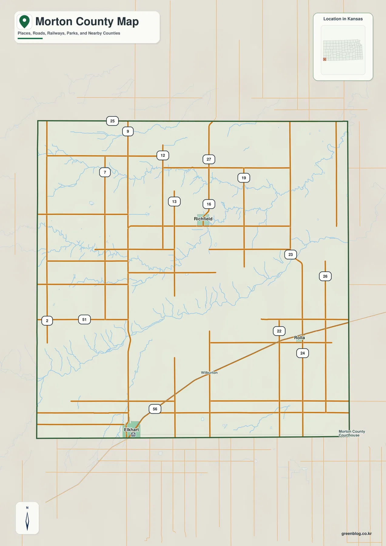
Morton County borders Colorado to the west and Oklahoma to the south, with Stanton County to the north and Stevens County to the east. That corner position helps explain why Elkhart functions as both a county center and a broader regional reference near two state lines.
The city-connections map puts Rolla east and Richfield north of Elkhart
The simplified city map focuses on three communities. Its printed city index lists Elkhart at 1,661, Rolla at 542, and Richfield at 17, with Elkhart marked as the hub. These are the values printed on the supplied map rather than a replacement for the latest official population estimates, but they make the relative size of the three markers immediately clear.
The panel shows Rolla about 16 direct miles from Elkhart and Richfield about 19 direct miles away. Rolla is east of the hub, while Richfield is north, so the three towns create a simple two-direction pattern. Those numbers are straight-line distances rather than driving distances, and actual road travel may be longer depending on the route.
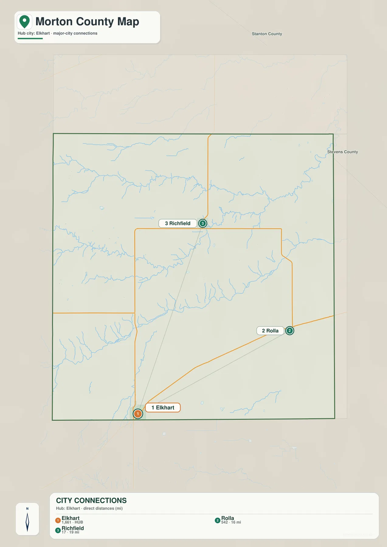
The southern and western parts of the county contain very few town markers by comparison. For those areas, the general road map and physical maps are more informative than the city layer because terrain, drainage, and state boundaries become more important than settlement spacing.
The North Fork Cimarron River crosses the northern half of the county
The North Fork Cimarron River is one of the most prominent features on the terrain-and-water map. It enters from the west, winds across the northern half of Morton County, and continues toward the east. Small tributaries join it from both sides, creating a long valley that becomes increasingly visible when compared with the elevation layer.
A separate Cimarron River channel crosses the south-central part of the county. It curves eastward through a lower corridor, while Spring Creek joins from the southwest. Harp Ditch and smaller drainage lines are also labeled, showing that the broad High Plains surface is cut by both major river valleys and much smaller channels.
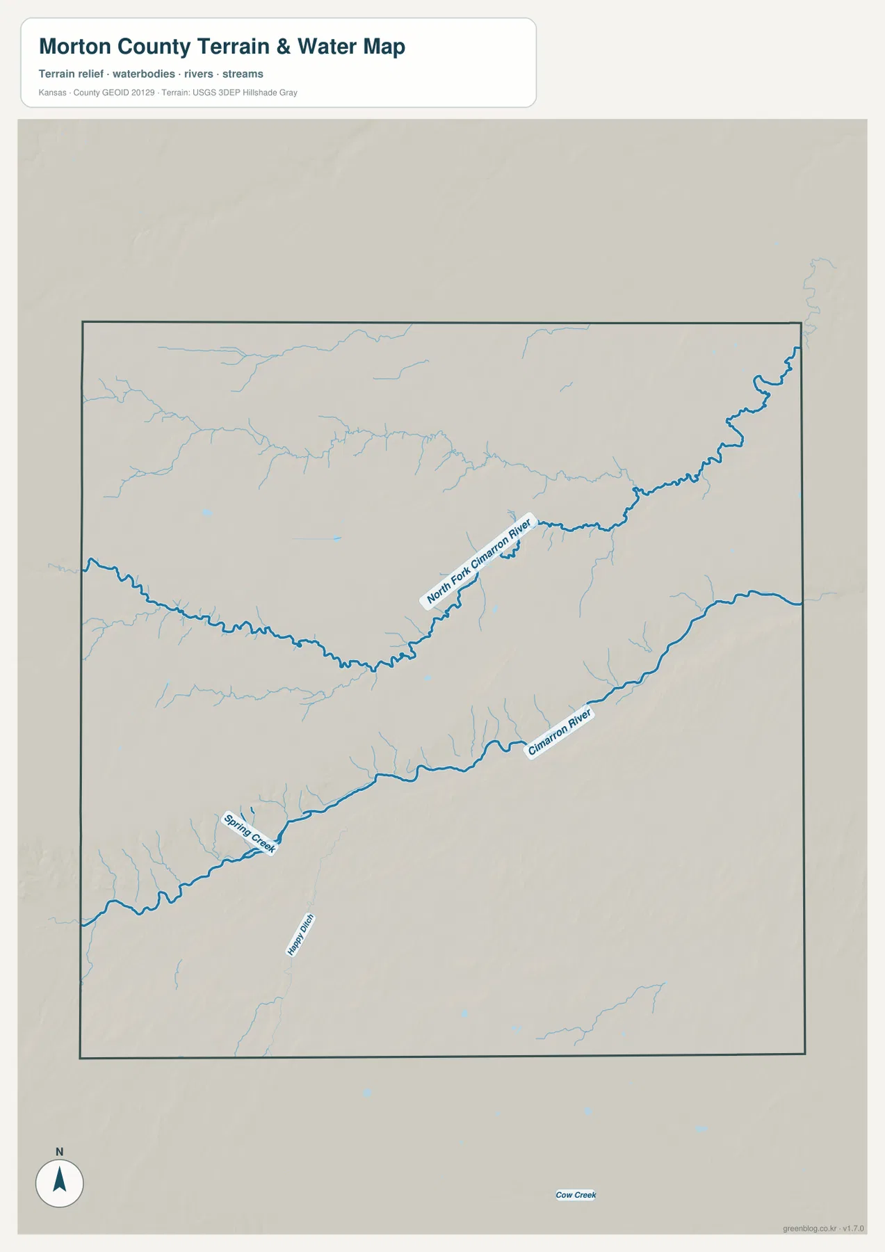
Much of the southern and western county is associated with Cimarron National Grassland. U.S. Forest Service material describes the grassland as covering about 108,000 acres in Morton and Stevens counties, combining shortgrass prairie with riparian corridors and other habitat. Kansas Tourism also highlights the Cimarron River valley and the broad grassland landscape around Elkhart.
This map is intended for geographic water reference, not flood-zone, navigation, water-quality, property, or access decisions. River depth and flow can vary greatly, especially in High Plains channels, so current conditions should be checked with the appropriate agency before field use.
Elevation from about 961 to 1,127 meters drops steadily toward the east
The elevation map spans roughly 961 to 1,127 meters, with a mean near 1,047 meters. The highest broad surfaces appear in the west and northwest, where brown and orange tones dominate. Farther east, the colors shift through yellow into green, creating a clear county-wide descent from the western High Plains toward lower river valleys.
The North Fork Cimarron River forms a long low corridor across the north, while the main Cimarron River creates another lower band through the south-central county. Between the two channels, higher plains and smaller tributary valleys alternate, so the land is not a simple flat slope even though the overall west-to-east trend is strong.
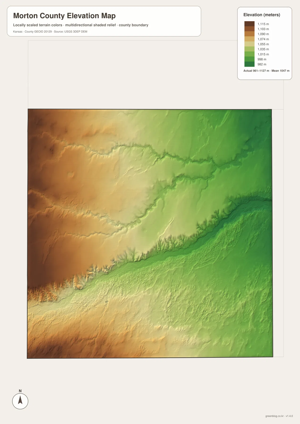
Near the eastern boundary, the river valleys widen and lower green terrain becomes more common. Western Morton County remains higher overall, with drainage cuts that are narrower and more widely spaced. The difference is particularly easy to see when the elevation map is placed beside the water map.
This elevation surface is generalized for county-scale comparison. It should not be used to establish parcel elevations, construction grades, drainage design, or legal boundaries. Detailed site work requires more precise official elevation data and, where appropriate, professional field surveying.
Cimarron National Grassland gives the county its best-known prairie landscape
Morton County is closely associated with Cimarron National Grassland, one of the most distinctive public-land landscapes in Kansas. U.S. Forest Service research describes the grassland as extending across Morton and Stevens counties and covering more than 108,000 acres of prairie and related vegetation. It was shaped by both natural High Plains conditions and land-use history following the Dust Bowl era.
Kansas Tourism presents Elkhart as a gateway to the grassland and highlights the Cimarron River valley, broad prairie views, and historic Santa Fe Trail features. On the supplied maps, the same landscape appears as long straight roads crossing high plains that are repeatedly cut by the North Fork Cimarron and Cimarron river valleys.
Elkhart’s position near Colorado and Oklahoma shapes the southwest corner
Elkhart is unusual among Kansas county centers because it sits very close to both the Colorado and Oklahoma boundaries. That position is easy to see on the county map, where the city lies near the southwestern edge rather than near the center. Kansas Tourism also identifies Elkhart as a southwestern Kansas community closely tied to Morton County and Cimarron National Grassland.
US 56 provides the clearest eastward route from Elkhart, while K-27 extends north into the county interior. Travelers moving west or south reach state boundaries quickly, making Elkhart a useful reference not only within Morton County but also for the extreme southwest corner of Kansas.
Use the road, city, water, or elevation layer according to the question
Choose the general county map when the priority is Elkhart, Rolla, Richfield, US 56, K-27, K-51, and the overall county boundary. The city-connections map is better for quickly comparing the three main communities and their direct spacing from Elkhart without route clutter.
Use the terrain-and-water map for the North Fork Cimarron River, the Cimarron River, Spring Creek, and smaller drainage lines. The elevation map is the strongest choice for explaining the higher western plains and lower eastern valleys. Moving between those physical layers makes the county’s broad west-to-east descent much easier to understand.
For large prints or presentation slides, use the original JPG files in the download archive rather than enlarging the web previews. The high-resolution versions preserve small road labels, river names, town text, and the elevation legend more clearly. If only part of a map is cropped, keep enough surrounding context—such as a north arrow, route number, or legend—to make the selected area understandable.
Frequently Asked Questions
Where are Rolla and Richfield relative to Elkhart?
Rolla is east of Elkhart and is shown about 16 direct miles away on the city-connections map. Richfield is north of Elkhart at about 19 direct miles. Those are straight-line distances rather than road distances.
Are the North Fork Cimarron River and Cimarron River shown as separate waterways?
Yes. The supplied water map shows the North Fork Cimarron River crossing the northern half of the county and the Cimarron River running through the south-central area. Smaller tributaries and channels connect to both valley systems.
Can the 961–1,127 meter elevation map be used for surveying?
No. It is a generalized county-scale terrain surface for comparing the High Plains with river valleys. Parcel elevations, engineering grades, drainage design, and legal boundary work require more precise official data and, where needed, professional surveying.
Map File Information
The archive contains the Morton County, Kansas general county map, city-connections map, terrain-and-water map, and elevation map as original high-resolution JPG files.
- Included Files: Use only the versions confirmed in the article and supplied images
- File Type: Use the confirmed download contents
- Intended Use: Printing, education, presentations, and map-based projects
Related Maps
Sources and references
- Kansas Tourism: Elkhart — Elkhart, Morton County, Cimarron National Grassland, and regional visitor context
- U.S. Forest Service: Geography, administrative roles, and users of Cimarron National Grassland — official research on the grassland’s geography and Morton County setting
- U.S. Census Bureau TIGER/Line Shapefiles — county boundary and geographic reference data
- USGS National Hydrography — river and stream reference data
- USGS 3D Elevation Program — elevation and terrain reference data
Green Map creates custom-edited map images using open geographic data sources such as geoBoundaries, Natural Earth, OpenStreetMap, and government open data.
These maps are edited visual materials, not raw data files, and are provided for education, documents, presentations, and graphic reference.