Allen County sits in southeastern Kansas with Iola as the clearest urban and road reference point. U.S. 54 runs east–west through Iola, Gas, La Harpe, and Moran, while Humboldt lies distinctly farther south and Savonburg is separated in the southeast. The four maps on this page can be viewed online and are also available as high-resolution JPG originals in a downloadable ZIP, which is useful when small stream names, road labels, or terrain details need to be enlarged or printed.
The county becomes more interesting when roads are compared with water and elevation. The Neosho River occupies a broad low corridor on the western side, while the eastern and northeastern parts rise into more strongly dissected uplands. Elm Creek, Coal Creek, Rock Creek, and other tributaries thread between those areas and drain toward either the Neosho or Marmaton systems. Looking across the general, settlement, water, and elevation maps reveals a county that is organized by both a strong east–west road corridor and two different drainage directions.
Iola lies a little west of the county’s center and provides the best starting point for orientation. The official Allen County website lists county offices in Iola, reinforcing the city’s role as an administrative reference as well as the largest settlement shown on the supplied city map. Once Iola is located, the eastward sequence of Gas, La Harpe, and Moran and the southward position of Humboldt make the rest of the county easier to place without relying on a dense network of minor roads.
Table of Contents
Start with Iola and the U.S. 54 Corridor
On the general county map, U.S. 54 is the simplest line to use for orientation. It crosses the northern half of the county from west to east, passing through Iola and continuing through Gas, La Harpe, and Moran. Near Iola, a major north–south route associated with U.S. 169 creates a second reference direction. These two lines reduce the apparent complexity of the local road grid: first find Iola, then follow U.S. 54 east toward Moran or trace the north–south route toward the Humboldt area.
South of Iola, Humboldt stands apart from the U.S. 54 chain and is accompanied by several numbered routes on the map, including 224, 57, and 169. Mildred appears near the northeast, while Elsmore is marked farther southeast. Places just outside Allen County, such as Piqua, Neosho Falls, and Bronson, provide useful context for how roads continue beyond the boundary. The map is intended for geographic orientation rather than live navigation, so current closures, construction, and travel conditions should be checked through up-to-date transportation sources before a trip.
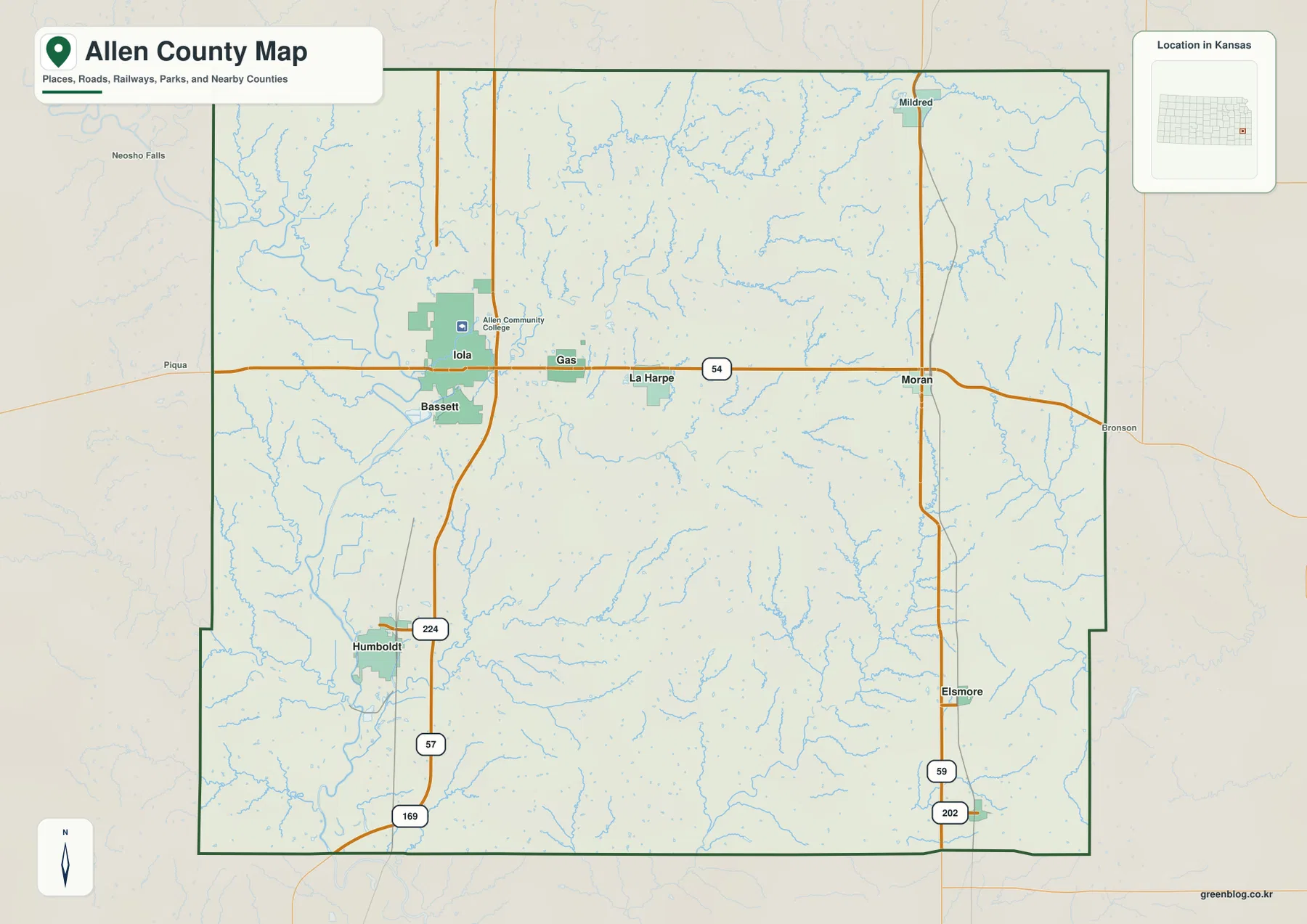
The boundary is mostly regular but includes small offsets, especially along the western and southwestern edges, so the county is not a perfect rectangle. Settlements are also not evenly spaced across the interior. Iola and the U.S. 54 corridor contain several named communities close together, while the southern half has larger gaps between Humboldt, Savonburg, and smaller places. That pattern is more useful than simply describing the county as having one central city surrounded by evenly distributed towns.
The general map is the best choice when roads, towns, county edges, rail lines, and smaller streams all need to remain visible together. It can look busy if the goal is to study only rivers or relief, but it gives the strongest overall framework. Keeping it open beside the specialized maps makes it easier to identify where a valley, lake, or high ridge sits relative to Iola, Humboldt, or the U.S. 54 corridor.
A Town Chain from Iola to Moran, with Humboldt to the South
The ranked city map simplifies Allen County to six principal settlements. Iola is shown as the largest, followed by Humboldt, with Gas, La Harpe, and Moran forming a set of smaller communities and Savonburg appearing as a much smaller southeastern settlement. The population values printed on the map are best treated as the map’s comparison values rather than a substitute for the newest official population estimate. The visual purpose is to show relative prominence and spacing.
Iola, Gas, La Harpe, and Moran occupy nearly the same east–west band, making the relationship between settlement and U.S. 54 especially clear. Gas sits close to Iola, La Harpe follows farther east, and Moran is positioned near the eastern side of the county. Humboldt breaks that pattern by lying well to the south, while Savonburg is even farther southeast. The result is a settlement geography with a strong northern east–west chain and a separate southern component rather than one compact cluster.
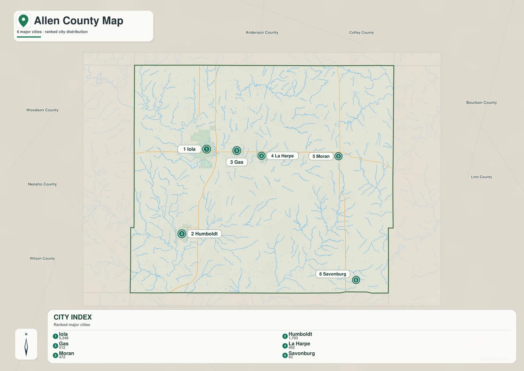
Neighboring county names around the frame provide another layer of orientation. Woodson and Neosho counties are shown to the west, Anderson and Coffey to the north, and Bourbon and Linn to the east, with Wilson County toward the southwest side. This context is useful when explaining which direction a local road or community faces beyond Allen County. Because the settlement map removes many minor labels, it is especially effective for comparing the spacing between Iola and Humboldt or between Moran and Savonburg.
The map also demonstrates why the largest settlement should not be treated as the only meaningful reference. Humboldt is important for understanding the southern part of the county, while Moran anchors the east. Gas and La Harpe may appear close to Iola, but they remain separate communities with their own locations. For a school project, local guide, or county overview, using these reference towns produces a clearer description than listing every place name without explaining how the communities are arranged.
Two Drainage Directions: Neosho River in the West and Marmaton River in the East
The terrain-and-water map has a very different visual structure from the road map. The Neosho River forms the dominant western lowland, bending south through a broad corridor where numerous small tributaries converge. Boyers Lake and Elks Lake sit close to this river system and help mark the valley. On the eastern side, the Marmaton River runs through a separate drainage network, while the South Fork Little Osage River appears in the northeast. The county’s interior therefore sits between two major river directions rather than around one single central river.
Several named creeks clarify how the interior is divided. Elm Creek runs across the central part of the county, Coal Creek crosses the south-central area toward the Neosho side, Rock Creek occupies part of the north-central interior, and Big Creek appears in the southeast. Their courses are much less regular than the road grid. When those winding channels are viewed with shaded terrain, it becomes easier to see why low corridors cut through areas that seem nearly uniform on the general map.
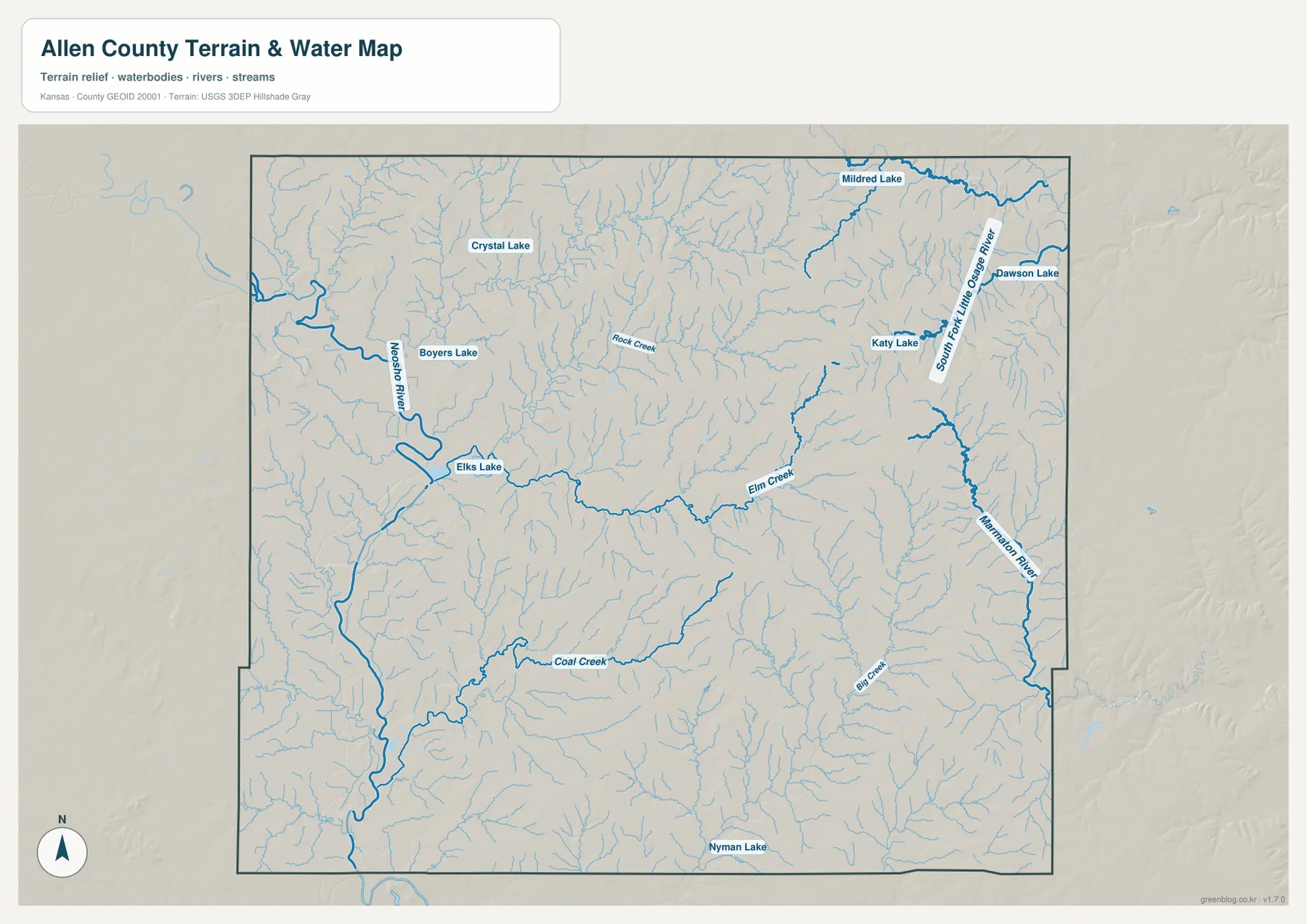
The named lakes add useful reference points. Crystal Lake lies in the north-central area, Boyers Lake and Elks Lake are near the Neosho River, and Mildred Lake, Dawson Lake, and Katy Lake are associated with the northeastern side. Nyman Lake appears near the southern edge. The map is valuable for locating these features and comparing them with nearby streams, but current water levels, public access, fishing rules, or boating restrictions can change and should be confirmed with the responsible local or state agencies.
This water map is not a flood-hazard, parcel, legal-drainage, or navigation product. A river shown here can rise or fall significantly, and a small creek can respond rapidly after heavy rain. The map is most appropriate for county-scale geographic understanding: where the Neosho system dominates, where the Marmaton and Little Osage branches collect water, and how tributaries cross the interior. For real-time flood or property decisions, current USGS and local government information is necessary.
274–354 Meters: Low Western Valleys and Higher Eastern Ground
The supplied elevation surface reports an actual range of about 274 to 354 meters, with a mean near 310 meters. The strongest broad contrast is between the western and southwestern Neosho River lowlands and the higher eastern half of the county. Green tones occupy the river corridor and adjacent valleys, while tan and brown colors become more common to the east and northeast. This makes the topographic difference much more visible than on the road map, where the county can appear relatively flat.
Iola occupies a useful transition area between these two terrain settings. Moving south toward Humboldt keeps the viewer close to the broad low Neosho corridor, while moving east from Iola through Gas, La Harpe, and Moran enters generally higher and more dissected ground. The eastern half is not a single flat upland, however. The Marmaton River and its tributaries carve lower green corridors through the higher terrain, creating narrow valleys and ridges that repeat across the map.
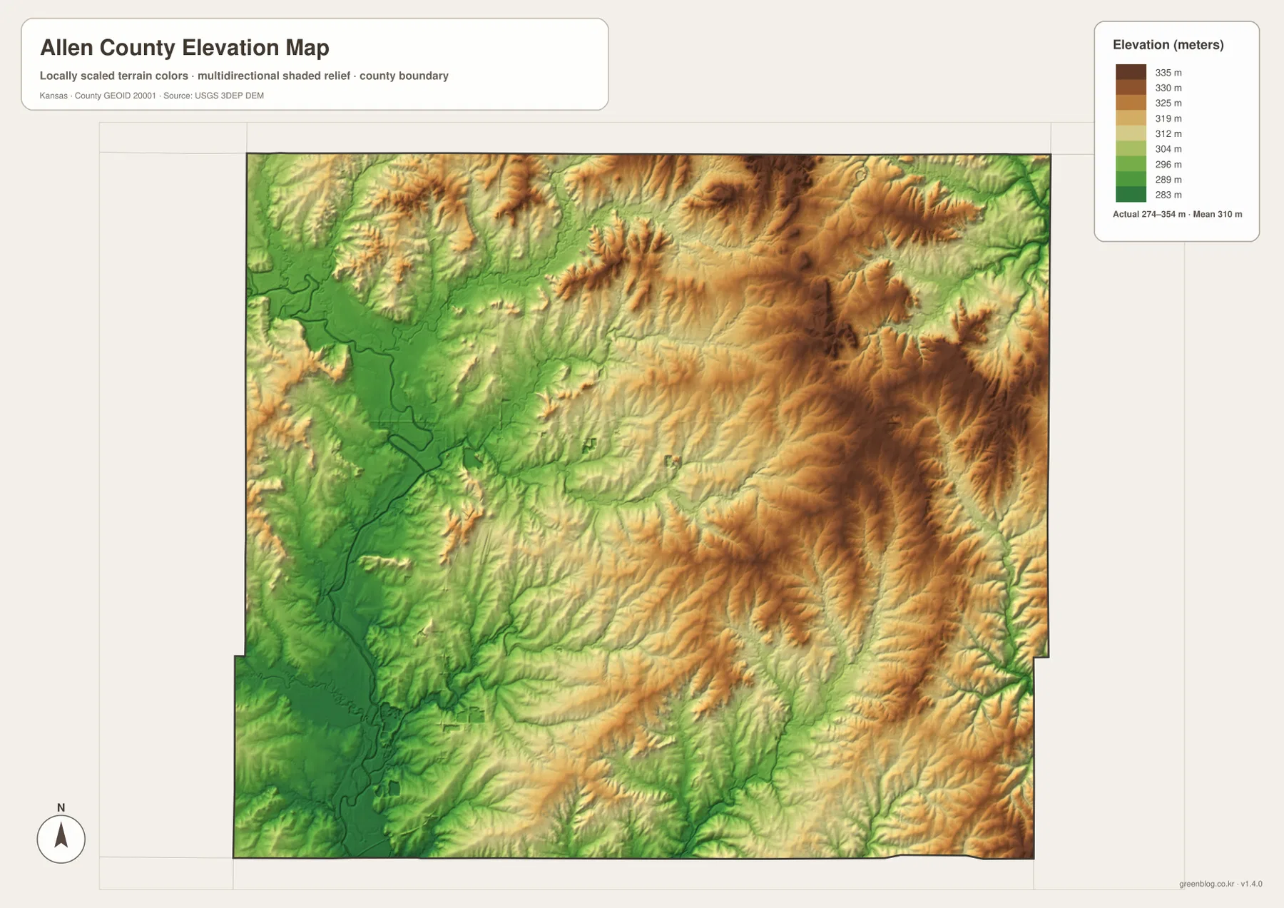
Comparing the water and elevation maps shows how closely the low colored bands follow the river and creek network. The Neosho River occupies the widest low corridor, while the Marmaton and South Fork Little Osage systems create narrower eastern valleys. Smaller creeks notch the central uplands in several directions. This pattern suggests multiple local divides across the county rather than one simple slope from one border to the other.
The elevation map is intended for broad regional comparison, not survey or engineering work. It can show major valleys, relative high ground, and the relationship between streams and relief, but it does not establish the exact elevation of a building site, property corner, road grade, or drainage structure. For county geography, trip planning, or comparing the Neosho lowlands with the eastern uplands, it provides a clear and useful overview.
How the Landscape Changes from Iola to Humboldt and Moran
Iola works well as the middle reference for two very different directions across Allen County. South toward Humboldt, the landscape stays close to the broad Neosho River lowland, where lower ground occupies a wider corridor. East toward Moran, the terrain generally rises and becomes more broken by the Marmaton River and smaller tributary valleys. Comparing those two directions shows why communities connected by the same county can sit in noticeably different physical settings.
Humboldt is separated from the U.S. 54 town chain, but its relationship to Iola becomes clearer when the Neosho corridor is used as a second reference. Both places sit near the western lowland system, although Humboldt is farther south and serves as a stronger marker for the county’s southern half. That setting helps explain why the surrounding relief looks broader and lower than the uplands farther east.
Moran provides the eastern contrast. It remains connected to Iola by U.S. 54, yet the land around it is higher and more closely tied to the Marmaton drainage. The road corridor therefore crosses a change in terrain rather than staying within one uniform landscape. Using Iola and Moran together is a useful way to explain how transportation, streams, and relief shift from the Neosho side of the county toward the eastern uplands.
For a class project or local overview, place-based comparisons are usually clearer than describing every map type in sequence. Start with the community or highway that matters, then add the nearby river system or elevation pattern only when it answers the next question. That approach keeps the geography connected to recognizable places instead of turning the article into a list of map layers.
Using the Maps Around a Place or Feature
When the question begins with a town or a route, the county map gives the most useful starting context because it keeps Iola, Humboldt, Gas, La Harpe, Moran, smaller places, and the principal roads in one view. If the goal is simply to compare the spacing and relative prominence of the main settlements, the ranked city view removes much of that detail and makes the U.S. 54 chain and Humboldt’s southern position easier to see.
Questions about the Neosho River, Marmaton River, Elm Creek, or named lakes are easier to answer when the water features are viewed with the surrounding relief. The broad western lowland and the higher eastern ground are especially clear when terrain and elevation are compared, and smaller tributaries make more sense once a nearby town or highway has already been located. This place-first approach avoids treating each map as an isolated product.
The web images are convenient for quick reference, while the downloadable ZIP contains the high-resolution JPG originals that correspond to the four maps on the page. Those files are more practical when small labels need to be enlarged, a map is being printed, or two views need to be kept open side by side. Readers can use only the file needed for a task or compare several when a location involves roads, streams, and relief at the same time.
Frequently Asked Questions
Which map is best for comparing Iola and Humboldt?
Start with the general county map because it shows the road relationship between Iola and Humboldt along with U.S. 54, the north–south highway corridor, and nearby place names. Then use the ranked city map if the main goal is to compare the relative prominence and spacing of the principal settlements without the distraction of secondary roads.
Where is the strongest elevation contrast in Allen County?
The clearest county-scale contrast is between the low Neosho River corridor in the west and southwest and the higher uplands toward the east and northeast. The supplied elevation surface ranges from about 274 to 354 meters, with a mean near 310 meters. Eastern river and creek valleys cut back into the high ground, so the east is not uniformly elevated.
Can the water map be used for flood or property-boundary decisions?
No. The map is a general geographic reference for features such as the Neosho River, Marmaton River, South Fork Little Osage River, Elm Creek, Coal Creek, and named lakes. Current flood conditions, legal property boundaries, drainage rights, public access, and road status should be checked with USGS, Allen County, and other responsible agencies.
Map File Information
The ZIP contains the high-resolution JPG originals corresponding to the Allen County general, city distribution, terrain-and-water, and elevation maps shown on this page.
- File Type: ZIP containing 4 JPG files
Related Maps
Sources and References
For county administration and local context, see the official Allen County website and its community information page. Boundary and base geography can be checked through the U.S. Census Bureau TIGER/Line files, water features through USGS National Hydrography, and terrain through the USGS 3D Elevation Program.
Green Map creates custom-edited map images using open geographic data sources such as geoBoundaries, Natural Earth, OpenStreetMap, and government open data.
These maps are edited visual materials, not raw data files, and are provided for education, documents, presentations, and graphic reference.