Adams County sits in southwestern Iowa, where a small group of communities is spread across a landscape cut by many streams and shallow valleys. The maps on this page show the county boundary, roads around Corning, the positions of Carbon, Prescott, and Nodaway, the water network around Lake Icaria, and the county’s changing elevation. A downloadable ZIP at the end of the article contains high-resolution JPG versions of the same four maps.
Corning is the easiest point of reference on the general map. Route 34 runs east and west through the central part of the county, while Route 148 approaches Corning from the north and continues through the area. Carbon lies to the northwest, Prescott to the east, and Nodaway to the southwest, giving the county a dispersed settlement pattern rather than a single line of towns.
The official Adams County website identifies Corning, Carbon, Nodaway, and Prescott as the county’s four cities. Those same places appear on the supplied maps, so the city layout provides a useful frame for reading the roads, waterways, and terrain. The sections below start with that human geography, then move into Lake Icaria and the Nodaway drainage, before using the elevation map to show how valleys and ridges shape the county.
Table of Contents
Corning anchors the road network without filling the county
The county map makes Corning stand out because several roads meet around the city. Route 34 forms the clearest east–west line across the map, while Route 148 reaches Corning from the north. Smaller county and local roads create a dense grid around these routes, especially east of Corning and across the southern half of the county.
Carbon appears northwest of Corning, close to a branching network of small streams. Prescott sits farther east and is connected to the central road system by several local routes. Nodaway is in the southwest, away from the denser road grid around Corning and Prescott. Looking at all four places together makes it easier to understand why Corning serves as the most convenient reference point for the rest of the county.
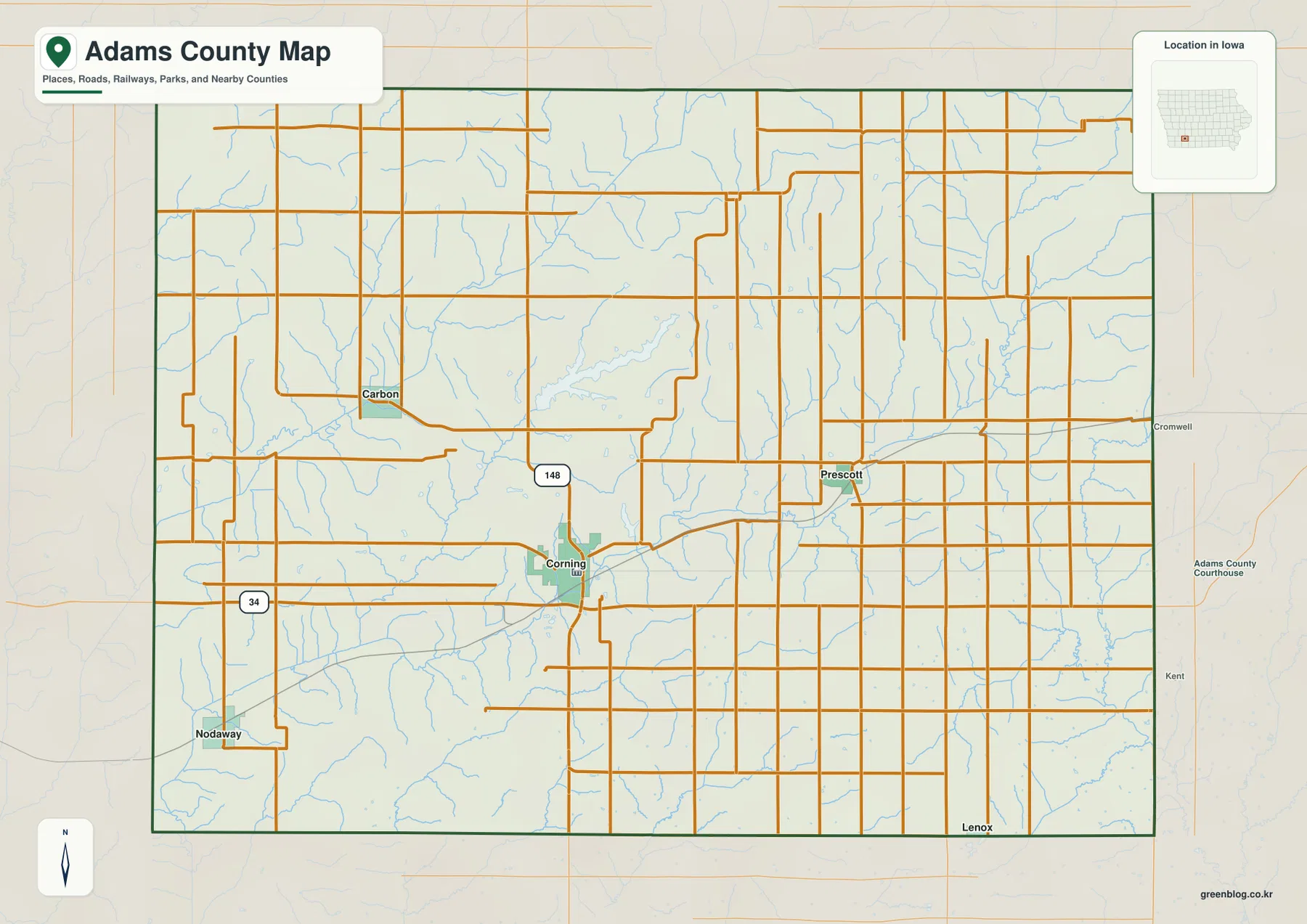
The map also includes some place names and roads beyond the county line. Labels such as Cromwell to the east and Lenox to the south help orient Adams County within the surrounding part of Iowa. These outside references are useful for location, but the map is not a turn-by-turn driving product, so current road conditions and routing should be checked separately before travel.
Thin blue streams cross nearly every part of the county map. Their density is a reminder that the rectangular road pattern sits on terrain broken by many small drainage valleys. When this map is compared with the water and elevation versions below, the relationship between straight rural roads, curving streams, and uneven ground becomes much easier to see.
Four communities spread west and east from Corning
The city-connections map strips away much of the road detail and focuses on the relative positions of the county’s four cities. Corning is marked as the hub. Prescott is east of it, Carbon is northwest, and Nodaway is southwest. This simplified view is useful when the main question is not which road to take, but how the communities are arranged across the county.
The legend also gives direct distances from Corning. Carbon is shown at about 6 miles, Prescott at about 7 miles, and Nodaway at about 9 miles. These are straight-line distances between the mapped points, not road mileage. A driver may travel farther because roads do not follow a direct line between every pair of communities.
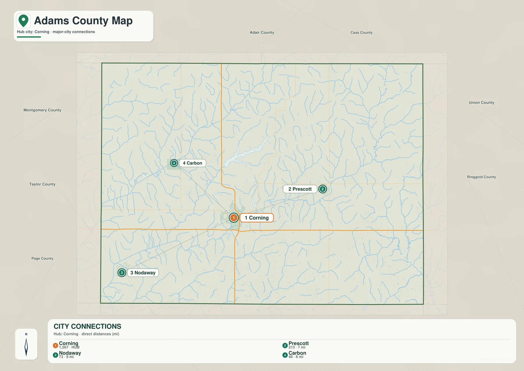
The direction of each city becomes more meaningful when the city map is compared with the general county map. Prescott lies in the eastern road grid, Carbon sits among the more branching stream network to the northwest, and Nodaway occupies the southwestern corner area. Corning remains the common reference because the two prominent numbered routes and several local roads converge near it.
County names around the edge of the city map provide broader orientation. Adair and Cass appear to the north, while Union and Ringgold are shown to the east and southeast; Montgomery, Taylor, and Page are labeled on the western side of the wider view. These labels help place Adams County in southwestern Iowa without crowding the center of the map with extra detail.
Lake Icaria sits among several separate river systems
The terrain-and-water map gives the streams far more emphasis than the road map. In the northwest, the Middle Nodaway River forms one of the most prominent blue lines. The East Nodaway River crosses the middle portion of the county, and many shorter tributaries join these larger channels from the surrounding slopes.
Lake Icaria is easy to recognize as a broad water body in the northwestern half of the county. Adams County Conservation describes it as a major local recreation area, which makes it more than a convenient map landmark. On the water map, the lake can be viewed in relation to nearby tributaries and the broader Nodaway drainage instead of as an isolated blue shape.
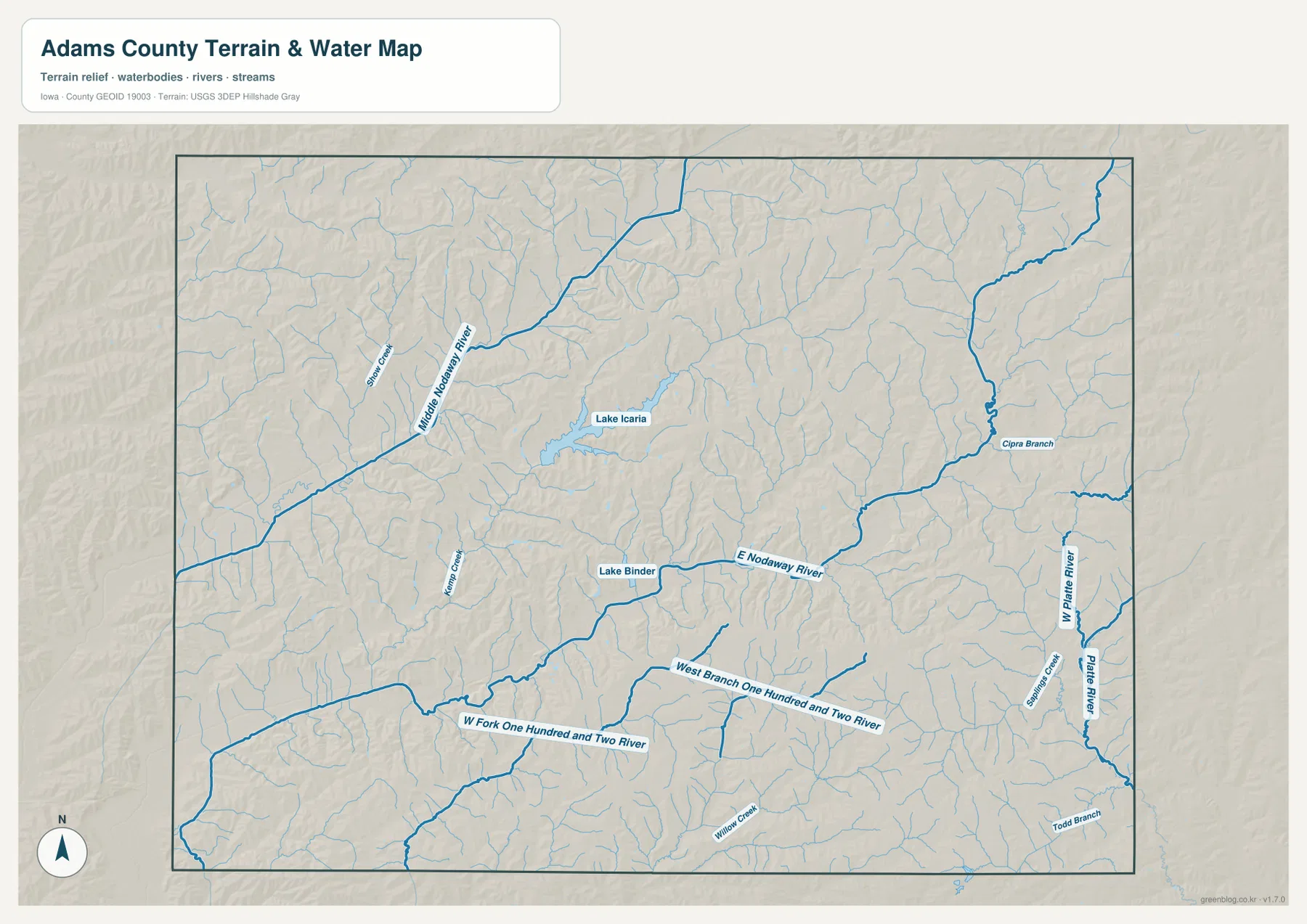
Lake Binder appears southeast of Lake Icaria and close to the East Nodaway River. It is smaller, but it helps locate the central drainage corridor. Reading the two lakes together with the labeled rivers makes the western and central parts of the county easier to separate visually.
Farther south, the West Fork One Hundred and Two River and the West Branch One Hundred and Two River cross long stretches of the county. Along the eastern side, the West Platte River and Platte River are labeled, with smaller creeks and branches feeding them. Adams County therefore does not drain toward just one obvious trunk river; several named systems divide the landscape into different sets of valleys.
This water map is intended for geographic reference. It does not show flood-insurance zones, legal water boundaries, water quality, or navigational conditions. Anyone making a flood, property, engineering, or recreation decision should use the appropriate current agency data in addition to this map.
Ridges rise above narrow green valley floors
The elevation map replaces town and road labels with locally scaled terrain colors. Its legend reports an actual elevation range of roughly 313 to 410 meters, with a mean near 372 meters. That span is enough to make the stream valleys stand out clearly from the higher ground between them.
Green shades mark the lower parts of the terrain, while tan and brown shades mark progressively higher ground. Broad lower corridors are visible in the western and central portions of the county, and many narrow side valleys branch away from them. The pattern matches the dense stream network seen on the water map: channels occupy low ground, while short ridges separate neighboring tributaries.
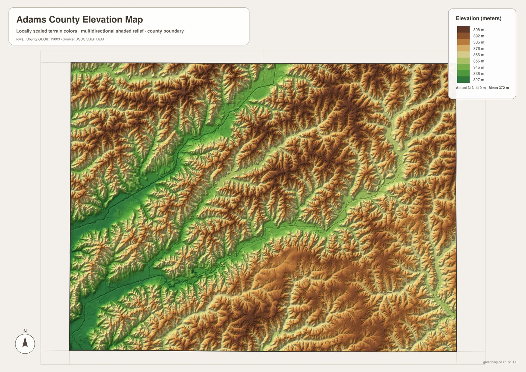
The county is therefore not represented as a uniformly flat surface even though many rural roads form straight north–south and east–west lines. Across the eastern and southern areas, narrow green valleys continue between higher ridges, producing repeated changes in relief over relatively short distances. The shaded surface makes those small landform changes easier to see than they are on the road map.
Because the colors are scaled for Adams County, they should be read as local differences rather than a universal color standard. A brown area here is higher than a green area within this map, but the same color on another county map may represent a different absolute elevation. The map is also a generalized terrain view, not a substitute for survey-grade measurements or engineering plans.
A practical way to use the elevation map is to find a place such as Corning or Prescott on the general map first, then compare that location with the terrain colors. The reverse approach is harder because the elevation version intentionally minimizes place labels. Used together, the maps connect settlement and road patterns with the valleys and ridges that occupy the same landscape.
Roads, water, and relief reveal different parts of the same county
The general county map is the best starting point when boundaries, roads, communities, and streams all matter at once. The city-connections map is deliberately simpler, letting Corning, Carbon, Prescott, and Nodaway stand out without a dense background of road names. Moving between those two maps separates detailed navigation context from a quick sense of where the communities sit.
The water and elevation maps form a second useful pair. A named river on the water map often lines up with a green low corridor on the elevation map. Starting with the water map helps identify the channel, while starting with the elevation map makes the valley itself obvious before the reader checks which stream occupies it.
Lake Icaria is a good example of how the same feature changes meaning from one map to another. On the county map, it is a recognizable water body northwest of Corning that helps with orientation. On the water map, it becomes part of a larger network of tributaries and rivers. On the elevation map, the surrounding low terrain matters more than the lake label itself.
Corning also changes role across the set. It is a road-centered reference point on the general map and the hub for straight-line city distances on the city map. The water and elevation maps then place that same central area within a landscape of branching drainage and ridges. Comparing the maps prevents any one layer from carrying more meaning than it was designed to show.
Choose a map by the detail you actually need
For a printed overview of Adams County, the general county map contains the broadest mix of information. It includes the county outline, Corning and the other communities, numbered routes, local roads, and many streams. It works well when a reader needs a single page that explains where places are in relation to both transportation and the county boundary.
The city-connections map is better for a quick comparison of community locations. Its direct-distance labels make Carbon, Prescott, and Nodaway easy to compare with Corning, but those values should not be treated as driving mileage. This version is especially useful in a presentation or classroom setting where too many secondary roads would distract from the main location question.
For lakes and rivers, use the terrain-and-water map. Lake Icaria, Lake Binder, the Nodaway channels, the One Hundred and Two River branches, and the Platte waterways are much easier to distinguish there than on the general map. The elevation map should be chosen when the question is about low valleys, higher ridges, or the way relief changes across the county.
The downloadable archive contains a high-resolution JPG corresponding to each map shown in the article. Each file is 3638 by 2572 pixels, providing more detail than the WebP previews used on the page. You can review the previews first, then download the full set when you need a larger image for printing, close inspection, or offline use.
Three limits matter when reading these maps
First, the distances on the city-connections map are straight-line measurements from Corning. A 7-mile label for Prescott does not mean every road route between the two points is 7 miles. Use the number to compare relative separation, then use current routing information for an actual trip.
Second, the terrain-and-water map is not a flood, parcel, or legal-boundary product. A stream line shows the mapped watercourse, not the limits of a floodplain or private property. Lake access rules, flood information, and land ownership should be checked with the agencies responsible for those subjects.
Third, the elevation surface is intended to show county-scale relief. The legend is useful for understanding which areas are lower or higher, but it cannot replace a site survey or engineering elevation. Keeping those limits in mind allows the four maps to remain useful for orientation, education, and general geographic reference without asking them to answer questions outside their purpose.
Taken together, the maps provide a compact portrait of Adams County that starts with Corning and the road grid, moves through the four communities, follows Lake Icaria and several river systems, and finishes with the ridges that separate those waterways. Selecting the layer that matches the question is more useful than trying to read every detail from a single image.
Frequently Asked Questions
Are the distances from Corning to Carbon, Prescott, and Nodaway road distances?
No. The city-connections map uses straight-line distances from the Corning hub point. It shows Carbon at about 6 miles, Prescott at about 7 miles, and Nodaway at about 9 miles. Actual road mileage depends on the route and should be checked with current navigation or road information.
Which map is best for Lake Icaria and the Nodaway rivers?
Use the terrain-and-water map when the main goal is to see Lake Icaria, Lake Binder, the Middle and East Nodaway rivers, and the other named waterways together. Pair it with the general county map if you also need roads and community locations, or with the elevation map if you want to compare the waterways with low valley terrain.
What is included in the downloadable ZIP?
The ZIP contains high-resolution JPG versions of the general county map, city-connections map, terrain-and-water map, and elevation map. Each image is 3638 by 2572 pixels, matching the four map topics shown in the article while providing more detail than the page previews.
Map File Information
Download the complete Adams County map set as high-resolution JPG files corresponding to the previews in this article.
- Printable Size: 3638×2572 pixels each
Related Maps
Sources and references
- Adams County Government – Communities — official information on Corning, Carbon, Nodaway, and Prescott
- Adams County Conservation — Lake Icaria and county conservation information
- U.S. Census Bureau TIGER/Line Shapefiles — county boundary, road, and place reference
- USGS National Hydrography — river and waterbody reference
- USGS 3D Elevation Program — elevation reference
Green Map creates custom-edited map images using open geographic data sources such as geoBoundaries, Natural Earth, OpenStreetMap, and government open data.
These maps are edited visual materials, not raw data files, and are provided for education, documents, presentations, and graphic reference.