Download the high-resolution Switzerland County JPG maps in one ZIP from the file box below. The archive contains the general county, city, terrain-and-water, and elevation views at 3638×2572 pixels each. On the page, the maps show Vevay beside a broad Ohio River bend, Patriot much farther east, Florence between the two riverfront communities, and East Enterprise in the hilly northern interior. They also trace the Indian Creek system, eastern tributaries, Lake Geneva, and the sharp rise from the river lowlands into 130–300 meter hill country.
This Switzerland County Map is easiest to follow from Vevay. Route 129 approaches from the northwest, Route 56 is labeled near the riverfront, and the Ohio River curves immediately south of the community. Moving east along the river side leads toward Florence and Patriot, while the road and stream pattern becomes much more broken inland around East Enterprise. The county’s unusual shape comes from the river itself, which defines most of the southern and eastern boundary.
The relief image explains why the interior looks so different from the river edge. Its legend shows an actual elevation range of about 130 to 300 meters, with a mean of 232 meters. Dark green follows the low Ohio River corridor, while tan and brown uplands cover much of the west and northwest. Narrow tributary valleys cut into those hills, so the county is a landscape of steep ridges and creek bottoms rather than a flat surface above the river.
Table of Contents
Vevay ties the riverfront roads to the hilly interior
Vevay is the clearest starting point on the general county map because the large Ohio River bend and nearby road labels make it easy to identify. Route 129 comes toward the community from the northwest, and Route 56 is marked along the river side. From there, the riverfront continues east to Florence and then Patriot, while inland roads climb toward the northern interior.
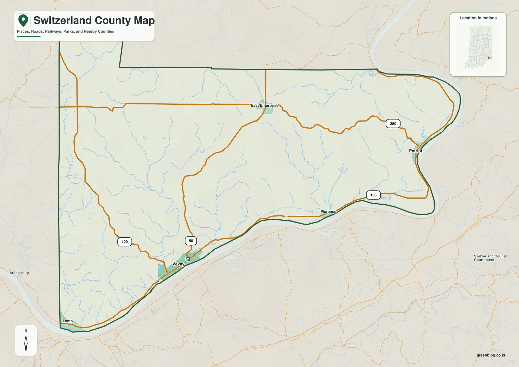
Florence occupies the river side between Vevay and Patriot, with Route 156 nearby. Patriot sits close to another large bend farther east, where Route 250 approaches from the interior. Although all three places are associated with the Ohio River, the curves of the river and the steep hills between tributary valleys make their positions less linear than a simple shoreline route would suggest.
East Enterprise belongs to a different setting. It lies in the northern interior where smaller roads cross between narrow valleys, well away from the broad riverfront. Using that settlement as an inland reference makes the change from low Ohio River ground to higher ridges much easier to understand.
The general county view is useful for route direction, named places, the river boundary, and the location of the interior roads. For actual travel, check a current road source because this county overview does not track temporary construction, closures, or changing restrictions.
Vevay and Patriot sit on separate sections of the Ohio River edge
The city view removes most road detail and highlights only Vevay and Patriot. Vevay lies in the western half of the southern riverfront, while Patriot is far to the east near the river’s northward bend. The broad hilly interior between them makes the two places feel like separate river references rather than one compact settlement area.
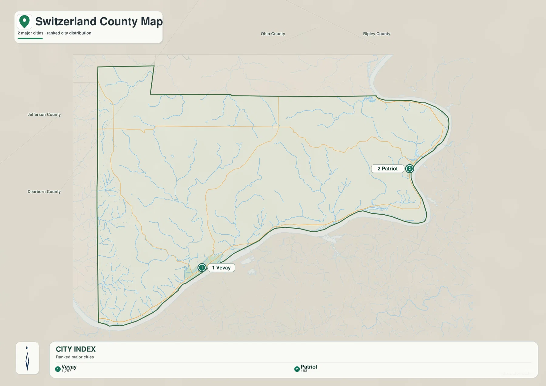
The CITY INDEX prints numeric values beneath both place names, but the supplied graphic does not state a year or a separate source for those numbers. This page therefore treats them only as labels on the supplied map rather than as current population counts. For up-to-date population, use a recent U.S. Census release.
Jefferson and Dearborn counties appear on the western side of the surrounding view, while Ohio and Ripley counties are labeled toward the north. Those neighboring names help place the straighter inland boundary above the long, curved Ohio River edge.
The two-city layout also helps organize the water map. Indian Creek and its branches occupy much of the western and central interior north of Vevay, while Grants Creek and Bryan Creek provide eastern references closer to Patriot. The riverfront communities therefore sit beside different groups of tributary valleys.
Indian Creek and smaller tributaries carve narrow valleys through the hills
Ohio River is the dominant water feature on the terrain-and-water map, forming the entire southern edge and then turning north along the east. From the interior, numerous tributaries descend toward the river. Indian Creek, West Fork Indian Creek, and Upper Indian Creek form the strongest named group across the west and central part of the county.
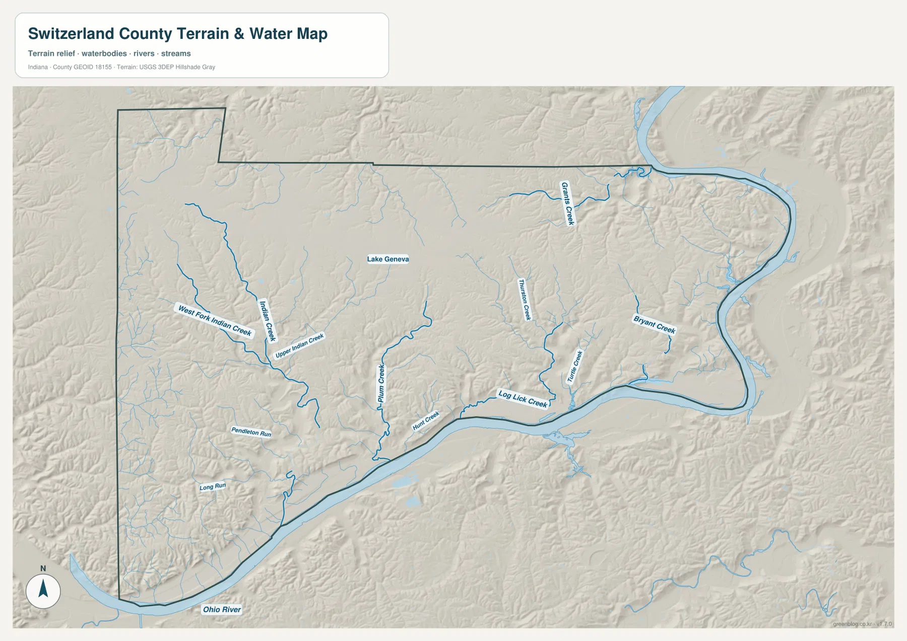
West Fork Indian Creek and the main Indian Creek channel pass through the western interior, with Upper Indian Creek labeled nearby. Smaller branches create a dense network of hollows between the ridges. Closer to the river, Plumb Creek, Hunt Creek, and Log Lick Creek create additional low corridors east of Vevay.
The eastern interior has a separate group of named tributaries. Grants Creek crosses the northeastern part of the county, while Bryan Creek appears farther south and east. Lake Geneva is marked as a compact inland water body near the north-central area and is easy to distinguish from the long branching creek valleys.
Use this water view to locate Switzerland County streams and Lake Geneva at county scale; it is not intended to define flood zones, property lines, legal water boundaries, water depth, drainage design, or navigation conditions. For a current flood situation or a site-specific drainage question, consult the agency data created for that purpose.
The terrain climbs quickly from the 130-meter river corridor into 300-meter uplands
The elevation legend gives Switzerland County an actual range of about 130 to 300 meters and a mean of 232 meters. On this county color scale, green marks the lower ground, while yellow and tan transition into brown across the higher ridges. The lowest broad corridor hugs the Ohio River along the south and east, closely following the river’s bends.
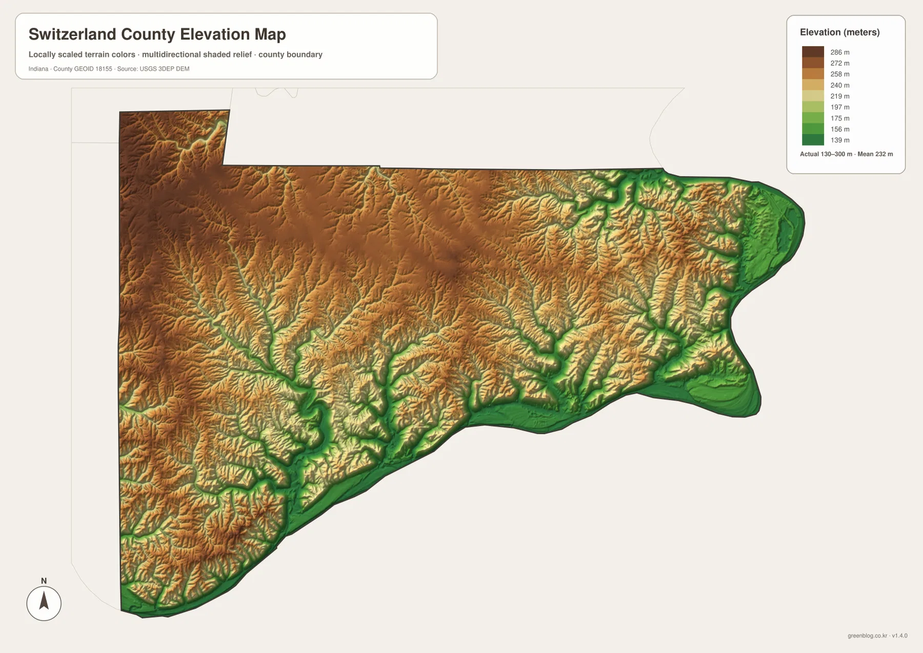
Much of the western and northwestern interior is high, but the uplands are deeply divided by stream valleys. Indian Creek and its branches align with green and light-green corridors that cut through the brown terrain. The repeated shift from ridge to hollow gives the map a rugged appearance even where the average elevation is high.
The eastern side repeats the same pattern on a smaller scale. Grants Creek and other tributaries cut lower passages through the hills, then the surface drops sharply again near the Ohio River around Patriot. Vevay shows a similar short-distance change between the low riverfront and the higher ground just inland.
The relief image is intended to compare broad elevation differences across Switzerland County, not to provide surveyed heights for individual sites. Do not use it to assign an exact elevation to a building, road point, parcel corner, or construction location. If a project depends on precise elevation, consult the underlying elevation data or a professional survey.
Use Vevay as the fixed point when switching between roads, streams, and elevation
For basic orientation, start with Vevay, Patriot, Routes 129 and 156, and the Ohio River edge on the general map. The city view is cleaner when the only question is where Vevay and Patriot sit relative to one another. Once those two places are fixed, Florence and East Enterprise are easier to place on the detailed road map.
For the physical landscape, locate Ohio River, the Indian Creek system, Plumb Creek, Grants Creek, and Lake Geneva on the terrain-and-water view. Then find the same areas on the relief map. The river corridor remains low, while the tributaries occupy narrow valleys cut into much higher interior ground.
The page uses smaller WebP previews so the Switzerland County maps load quickly in a browser. The ZIP preserves the four full-resolution JPG originals—county, city, terrain-and-water, and elevation—rather than those reduced previews. Each original is a landscape image measuring 3638 by 2572 pixels, leaving more detail for close inspection of road and creek labels or for A3 output.
A practical comparison routine is to keep Vevay fixed. Find the Ohio River and Routes 56 and 129 on the road map, trace Indian Creek and Plumb Creek on the water view, and then open the elevation image to compare the green river lowland with the brown western and northwestern hills.
Frequently Asked Questions
What is the easiest place to use as a starting point on the Switzerland County maps?
Vevay is the most useful starting point because it sits beside a large Ohio River bend and is close to the Route 56 and Route 129 references. From Vevay, Florence and Patriot can be followed east along the river side, while East Enterprise provides a northern inland reference.
Are Indian Creek and Grants Creek the same waterway?
No. Indian Creek and its branches occupy the western and central interior, while Grants Creek is a separate tributary in the eastern and northeastern part of the county. Both ultimately belong to the broader Ohio River landscape, but they follow different valleys.
Where does the elevation map show the strongest terrain contrast?
The clearest contrast is between the low Ohio River corridor along the southern and eastern edge and the high western and northwestern hills. The map legend reports an actual elevation range of about 130–300 meters and a mean of 232 meters, with tributary valleys cutting deeply into the uplands.
Map File Information
The ZIP contains the full-resolution JPG originals for the Switzerland County general, city, terrain-and-water, and elevation views. Choose these files when you need to enlarge local road or creek labels or prepare an A3 print.
- Printable Size: 3638×2572 px each
Related Maps
Sources and References
The road, settlement, water, and elevation descriptions above are based on the supplied Switzerland County maps and asset information. The references below point to official boundary, water, and elevation sources that can be consulted when more detailed source data are needed.
- U.S. Census Bureau TIGER/Line Shapefiles – official county boundary, road, and place reference data
- USGS National Hydrography – official river, creek, and inland water data information
- USGS 3D Elevation Program – elevation source data and program information
Green Map creates custom-edited map images using open geographic data sources such as geoBoundaries, Natural Earth, OpenStreetMap, and government open data.
These maps are edited visual materials, not raw data files, and are provided for education, documents, presentations, and graphic reference.