Perry County combines a compact Ohio River settlement area around Tell City and Cannelton with a much larger interior of ridges, creek valleys, and forest lakes. You can download the high-resolution JPG ZIP directly from this page. The larger files make road shields, stream labels, lake outlines, and relief shading easier to read. This Perry County Indiana Map page brings together the county road network, a Tell City–centered connection map, the Ohio and Anderson river systems, and a 111–267 meter elevation surface with strong relief across the northern and eastern interior.
Tell City is the most useful starting point. It has the largest developed footprint and the Perry County Courthouse label, while Cannelton sits immediately to the south along the Ohio River. Troy is farther northwest near the western river boundary, and Leopold provides a useful inland reference near the center of the county. Roads 145 and 237 organize the Tell City–Cannelton side, while Routes 37, 66, 70, and 166 are more useful for the large interior and southern river bends.
The physical maps make the county’s contrast especially clear. Anderson River and Middle Fork Anderson River occupy lower corridors in the northwest and west-central interior. Indian Lake, Lake Celina, and Tipsaw Lake form a recognizable inland lake group. Farther east, Oil Creek cuts a long valley, and Poison Creek and Bear Creek descend toward the Ohio River. The elevation legend reports an actual range of about 111 to 267 meters and a mean of 170 meters, with very low river margins beside closely spaced high ridges.
Table of Contents
Tell City and Cannelton form the main riverfront road cluster
Tell City and Cannelton create the most continuous developed area on the general map. State Road 145 leaves the Tell City side toward the interior, while State Road 237 follows the Cannelton area close to the Ohio River. The road pattern changes quickly outside the urban strip: short valleys, wooded ridges, and river bends force routes to curve more often than they do within the riverfront towns.
Troy lies northwest of Tell City close to the county boundary and the river system. Farther north, State Roads 62 and 64 provide useful references across the upper western county. St. Meinrad appears outside the county to the west on the basemap, so it works only as surrounding context; Troy and Tell City remain the more reliable Perry County references on this side.
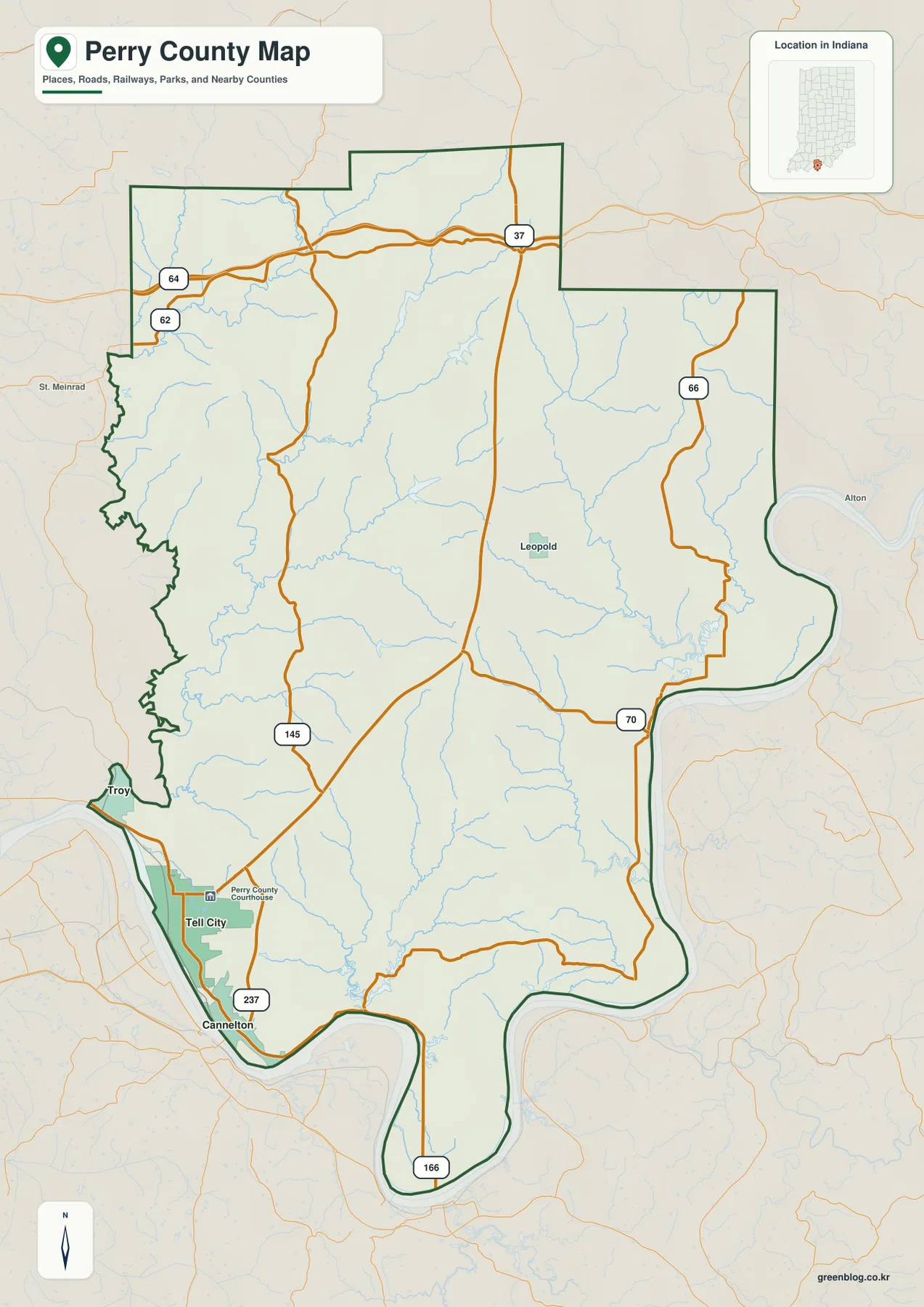
State Road 37 runs north-south through the middle of the county and passes west of Leopold before joining the southern road network. State Road 66 follows the eastern side in a more winding line, and State Road 70 crosses the southeast toward the river. These roads are especially valuable because large sections of northern and eastern Perry County have few sizable settlement labels.
The southern tip is shaped by a major Ohio River bend. State Road 166 follows the long narrow lower section before the county boundary curves back north. This is a very different landscape from the Tell City urban area: development is sparse, the river dominates the outline, and narrow valleys repeatedly descend from the interior hills toward the water.
The connection map compares Cannelton and Troy directly with Tell City
The supplied connection map uses Tell City as the hub at 7,505. Cannelton is printed at 1,404 with a direct distance of about 3 miles, and Troy at 608 with a direct distance of about 4 miles. Those distances are straight-line distances shown by the map, not driving distances. The three places cluster on the western and southwestern river side, illustrating how Perry County’s main settlement concentration differs from its sparsely settled interior.
| Rank | Place | Value printed on map | Direct distance from Tell City |
|---|---|---|---|
| 1 | Tell City | 7,505 | Hub |
| 2 | Cannelton | 1,404 | About 3 mi |
| 3 | Troy | 608 | About 4 mi |
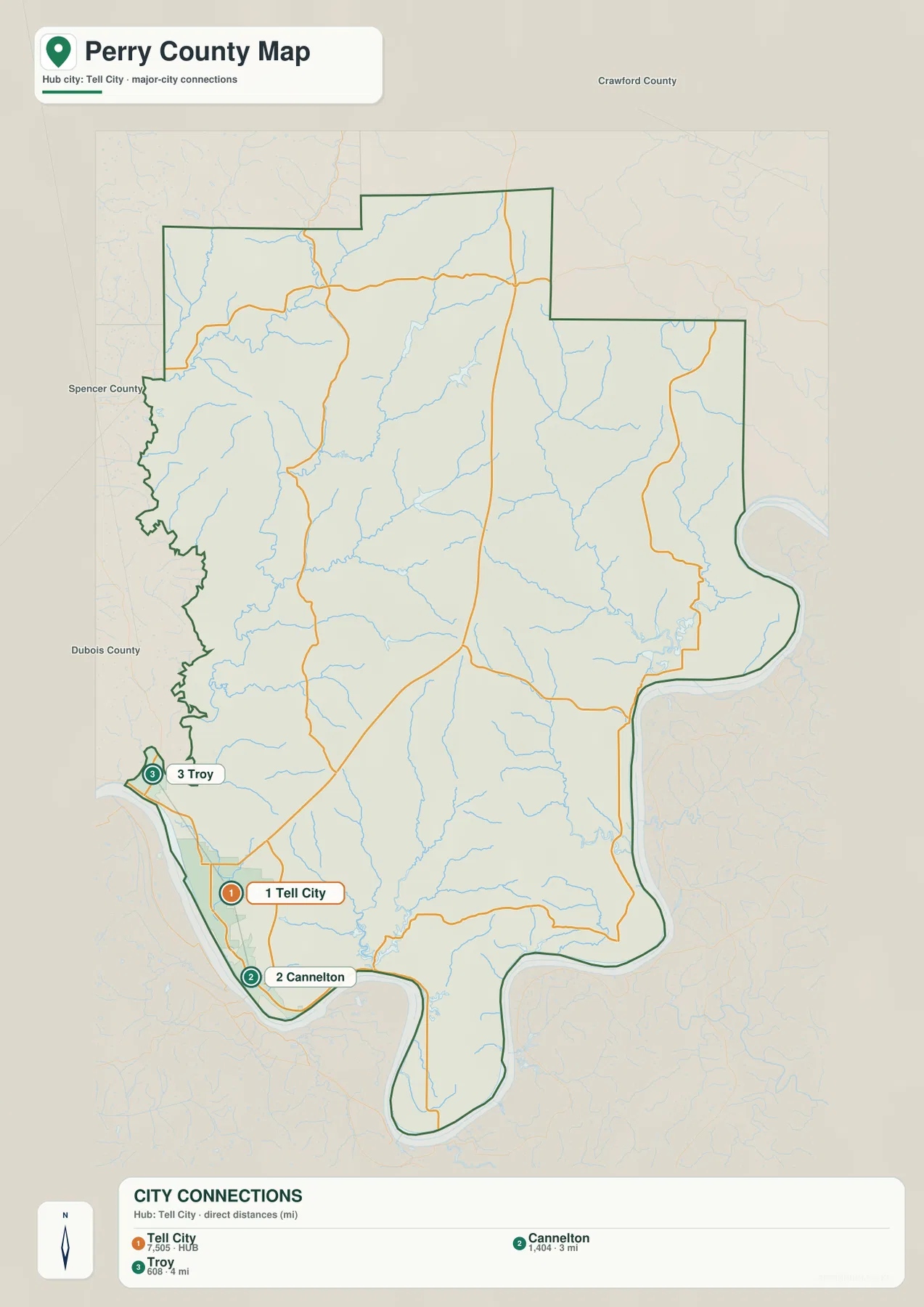
The connection map is intentionally simpler than the general county map. Leopold does not appear in the three-place ranking even though it is a useful inland label, and the northern and eastern county contains long road and drainage corridors with few large settlements. Use this view for comparing the riverfront towns; return to the general map when the goal is countywide orientation.
The printed city values belong to the supplied map edition rather than a live demographic feed. Likewise, the 3- and 4-mile figures should not be used as road-trip distances. Actual driving mileage depends on the route, bridge access, and the exact starting and ending points, so road navigation requires a current routing source.
Anderson River and the Indian–Celina–Tipsaw lake country define the interior lowlands
Anderson River is the strongest named drainage feature in the northwest. It bends through lower ground and is joined by a network of smaller valleys, while Middle Fork Anderson River creates another pronounced low corridor farther south. On the elevation map, both river systems remain green as the surrounding ridges rise quickly on either side.
Indian Lake and Lake Celina sit close together in the north-central interior, and Tipsaw Lake lies farther south. USDA Forest Service material for Hoosier National Forest identifies Indian–Celina Lakes and Tipsaw Lake as established recreation areas in the southern forest. Their locations on the supplied map also make them practical fixed points for understanding Perry County’s heavily wooded inland terrain.
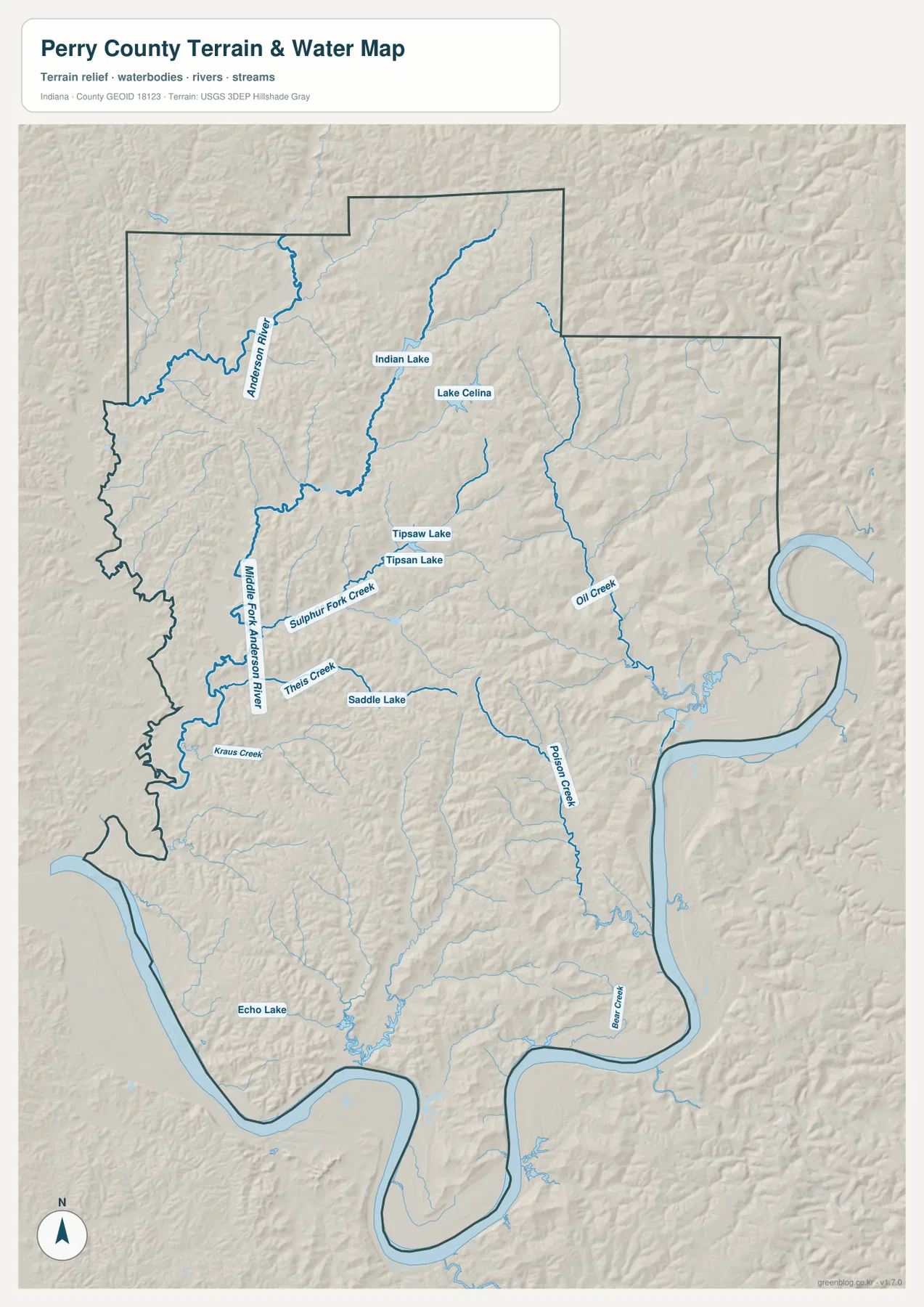
Sulphur Fork Creek and Theis Creek cross the middle-west, with Saddle Lake providing a small fixed water landmark nearby. Kraus Creek lies farther southwest, and Echo Lake appears in the lower interior. Oil Creek is a strong eastern feature, while Poison Creek and Bear Creek descend through the southeast. These smaller channels matter because many of Perry County’s road curves and ridges make more sense once the drainage pattern is visible.
Ohio River wraps around much of the eastern and southern boundary and creates the county’s broadest lowland edge. The terrain-and-water image is intended for geographic orientation rather than regulatory decisions. Flood conditions, current water levels, water quality, navigation rights, property ownership, and legal stream boundaries require current agency or local information.
The 111–267 m relief climbs abruptly from the Ohio River into the northeastern ridges
The elevation legend gives an actual Perry County range of about 111 to 267 meters and a mean of 170 meters. Low ground appears in green, while yellow, tan, and brown indicate higher terrain. The Ohio River margin is among the lowest areas, and the northeastern and east-central interior contains broad zones of much higher brown relief.
Northern Perry County is strongly dissected rather than smoothly rolling. Short ridges repeat between the Anderson River system, lake basins, and small creek valleys. Indian–Celina and Tipsaw areas remain relatively low within that terrain, but steep-looking bands of higher ground rise immediately around many of the drainage corridors.
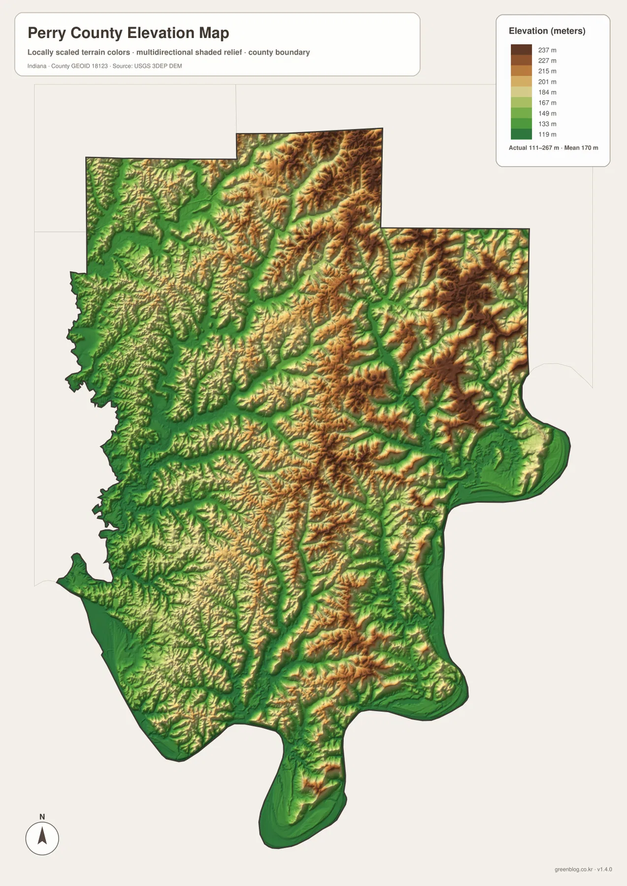
The west-central interior and land north of Tell City are lower on average than the northeastern ridge country, but they are far from flat. Middle Fork Anderson River and many smaller streams cut narrow green grooves through repeated hills. Near Tell City and Cannelton, the land drops toward the Ohio River and then rises again quickly only a short distance inland.
This surface is useful for countywide comparison, not for engineering measurements. For a Perry County parcel, forest road, building site, slope calculation, or drainage project, use original USGS elevation data or a qualified survey instead of relying on this generalized county relief image.
Keep Tell City fixed while matching the Ohio River with Anderson River and the inland lakes
For settlements and roads, begin with Tell City and Cannelton on the riverfront. Add Troy to the northwest, Leopold in the interior, and then follow Routes 145, 37, 66, 70, 166, and 237 to organize the remaining county. This approach is especially useful because northern and eastern Perry County has far fewer large town labels than the riverfront strip.
The connection map is best for comparing Tell City, Cannelton, and Troy. It shows both the printed city values and the direct distances from the hub, while the general map supplies the missing inland context. Using both views prevents the compact western settlement cluster from being mistaken for the geographic center of the whole county.
For terrain, use Ohio River as the outer lowland reference and then move inward to Anderson River, Middle Fork Anderson River, Indian Lake, Lake Celina, and Tipsaw Lake. Switching to the elevation image at those same locations makes the county’s main pattern clear: low river and creek corridors surrounded by short, repeated ridges that become especially high in the northeast and east-central interior.
The WebP images are reduced previews for faster page viewing. The Perry County archive contains four original 2572×3638-pixel JPG files covering the general county map, city connection map, terrain-and-water map, and elevation map. Use the larger originals when road shields, creek names, lake outlines, or ridge details need to stay legible in print.
A useful comparison is to keep Tell City fixed as the riverfront reference. Find Cannelton, Troy, and Leopold on the general map, compare the three connection values, move to the water view to trace Anderson River and the Indian–Celina–Tipsaw lakes, and finish on the elevation image by comparing the Ohio River lowlands with the high northeastern ridges.
Frequently Asked Questions
Are the 3-mile and 4-mile city values driving distances?
No. The connection map labels Cannelton at about 3 miles and Troy at about 4 miles from Tell City as direct, straight-line distances. Driving distances can be longer because the route follows the Ohio River, local road curves, and specific street access.
Which rivers and lakes are easiest to recognize?
Ohio River is the dominant outer water reference, while Anderson River and Middle Fork Anderson River organize the northwest and west-central interior. Indian Lake, Lake Celina, and Tipsaw Lake are strong inland landmarks. The water image is for geographic orientation rather than flood, parcel, or legal-boundary decisions.
Can the 111–267 m elevation range be used for exact site measurements?
No. The image gives a county-wide range with a mean of 170 meters and is intended for comparing river lowlands, creek valleys, and ridge country. For exact elevation on a Perry County parcel, construction site, road grade, or drainage project, use original elevation data or a qualified survey rather than the county-scale image.
Map File Information
The Perry County ZIP combines the general road-and-place map, Tell City connection map, terrain-and-water map, and elevation map as full-resolution JPG originals.
- File Type: ZIP containing four 2572×3638px JPG files
Related Maps
Sources and References
The article is based primarily on the supplied Perry County map set and asset manifest. The following official sources provide county, Hoosier National Forest, boundary, hydrography, and elevation context.
- Perry County, Indiana Government – official county government and courthouse information based in Tell City
- USDA Forest Service – Hoosier National Forest – official information for the southern forest, including Indian–Celina Lakes and Tipsaw Lake recreation areas
- U.S. Census Bureau TIGER/Line Shapefiles – boundary reference for Perry County and its place framework
- USGS National Hydrography – reference data for Ohio River, Anderson River, creeks, and mapped lakes
- USGS 3D Elevation Program – source terrain data for precise elevation work beyond the county-scale relief image
Green Map creates custom-edited map images using open geographic data sources such as geoBoundaries, Natural Earth, OpenStreetMap, and government open data.
These maps are edited visual materials, not raw data files, and are provided for education, documents, presentations, and graphic reference.