Parke County is centered on Rockville, with Montezuma and Mecca toward the Wabash River, Rosedale in the south, and Bloomingdale and Marshall in the northern half. This page provides a high-resolution JPG ZIP for direct download when larger road shields, creek names, lake outlines, or elevation shading are needed. The Parke County Map set brings together the Rockville road network, a six-place city index, Wabash River and the Sugar–Raccoon creek systems, and a 140–256 meter relief surface that rises sharply away from the western river lowlands.
Rockville is the most useful starting point because it is the county seat and the clearest developed center. State Road 36 crosses the county through town, while Routes 41, 59, 47, 236, and 234 help separate the western river corridor, northern hill country, and eastern interior. Montezuma lies on the Wabash side, Mecca is farther south along the western lowlands, and Rosedale marks the southern end of the settlement pattern. Bloomingdale and Marshall provide smaller references north of Rockville.
Parke County’s physical geography becomes much clearer on the water and elevation views. Wabash River forms the winding western boundary, Sugar Creek cuts a deep corridor across the north, and Big Raccoon Creek crosses the lower county. Cecil M. Harden Lake occupies the southeast as the largest water body on the supplied map. The elevation legend reports an actual range of about 140 to 256 meters and a mean of 196 meters, with low green river flats in the west and higher tan-brown ridges toward the east and northeast.
Table of Contents
Rockville links the central road network to the Wabash lowlands and eastern hills
Rockville has the strongest developed footprint on the general map. State Road 36 crosses the town from west to east, while Routes 41 and 59 connect the central area to the southern county. Because several numbered roads converge nearby, Rockville is the easiest place to anchor the rest of the map before moving toward the Wabash River or the more broken terrain to the east.
Montezuma sits close to the western boundary beside the Wabash River, while Mecca lies farther south in the same broad lowland. Their positions make the river corridor easy to recognize even on the road map. Smaller roads and creek crossings become increasingly important between these towns and Rockville because the land rises out of the river valley into rolling interior ridges.
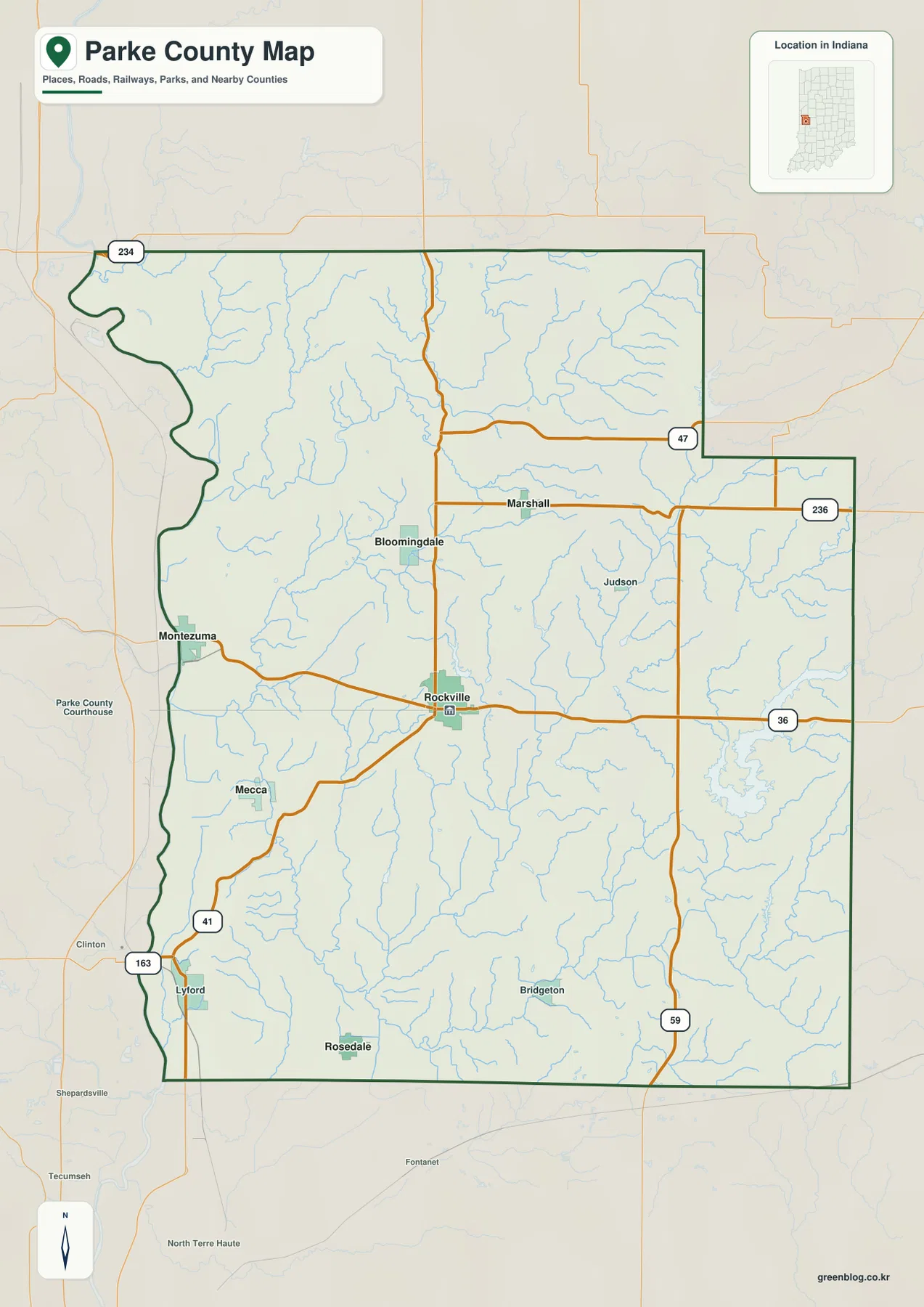
Bloomingdale lies north and west of Rockville, while Marshall appears farther east in the same general part of the county. State Road 47 divides the northeastern side and State Road 236 crosses east of Marshall. Route 234 follows the upper county, where roads weave through creek valleys rather than following the simpler pattern seen near the western river plain.
Rosedale lies near the southern edge, and Bridgeton provides a smaller southeastern reference on the general map. State Road 59 runs down the eastern half, while Lyford and Routes 41 and 163 help locate the southwest. The county boundary itself is useful: the west follows the winding Wabash River, whereas the eastern side is mostly a stepped administrative line.
The six-place index shows Rockville well ahead of the smaller towns
The supplied city index ranks Rockville, Montezuma, Rosedale, Mecca, Bloomingdale, and Marshall. Rockville is printed at 2,559, Montezuma at 881, Rosedale at 609, Mecca at 607, Bloomingdale at 324, and Marshall at 266. These are values printed on the supplied map edition rather than a live demographic feed. Their main use here is comparing one central county seat with several much smaller communities spread across the west, south, and north.
| Rank | Place | Value printed on map | Position |
|---|---|---|---|
| 1 | Rockville | 2,559 | Central |
| 2 | Montezuma | 881 | West |
| 3 | Rosedale | 609 | South |
| 4 | Mecca | 607 | Southwest |
| 5 | Bloomingdale | 324 | North-central west |
| 6 | Marshall | 266 | North-central east |
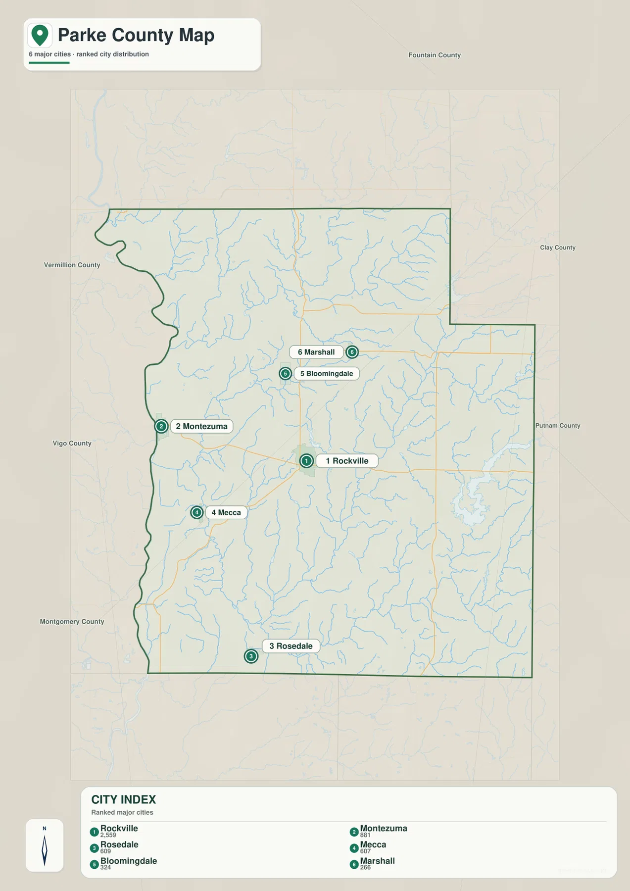
The size difference between Rockville and the other highlighted communities is substantial. Montezuma is the strongest western reference, while Rosedale and Mecca have nearly identical printed values but occupy different parts of the county. Bloomingdale and Marshall are much smaller, yet they are useful for separating the northern creek-and-ridge country into western and eastern sections.
Bridgeton, Judson, and Lyford appear on the general map but not in the six-place index. Return to the general view when these smaller labels or exact road connections matter. The index is better for a quick comparison of the six highlighted settlements. Present-day Parke County population totals should come from a current official statistical source rather than treating the printed values as live counts.
Wabash River, Sugar Creek, and the Raccoon creeks define three distinct lowland systems
Wabash River is the clearest boundary feature on the terrain-and-water map. It follows the western edge in a long series of bends and collects smaller streams flowing out of the interior hills. Leatherwood Creek and Rock Run are among the visible tributary references. The river corridor is broad and low, making Montezuma and Mecca easy to relocate when the road labels are removed.
Sugar Creek crosses the northern county through a much narrower valley. Roaring Creek and Sugar Mill Creek connect with this drainage, and the shaded relief shows steep short ridges on both sides. Indiana DNR describes Turkey Run State Park along Sugar Creek as a landscape of deep sandstone ravines, forest, and scenic creek views. That official context matches the strongly incised northern terrain visible on the supplied map.
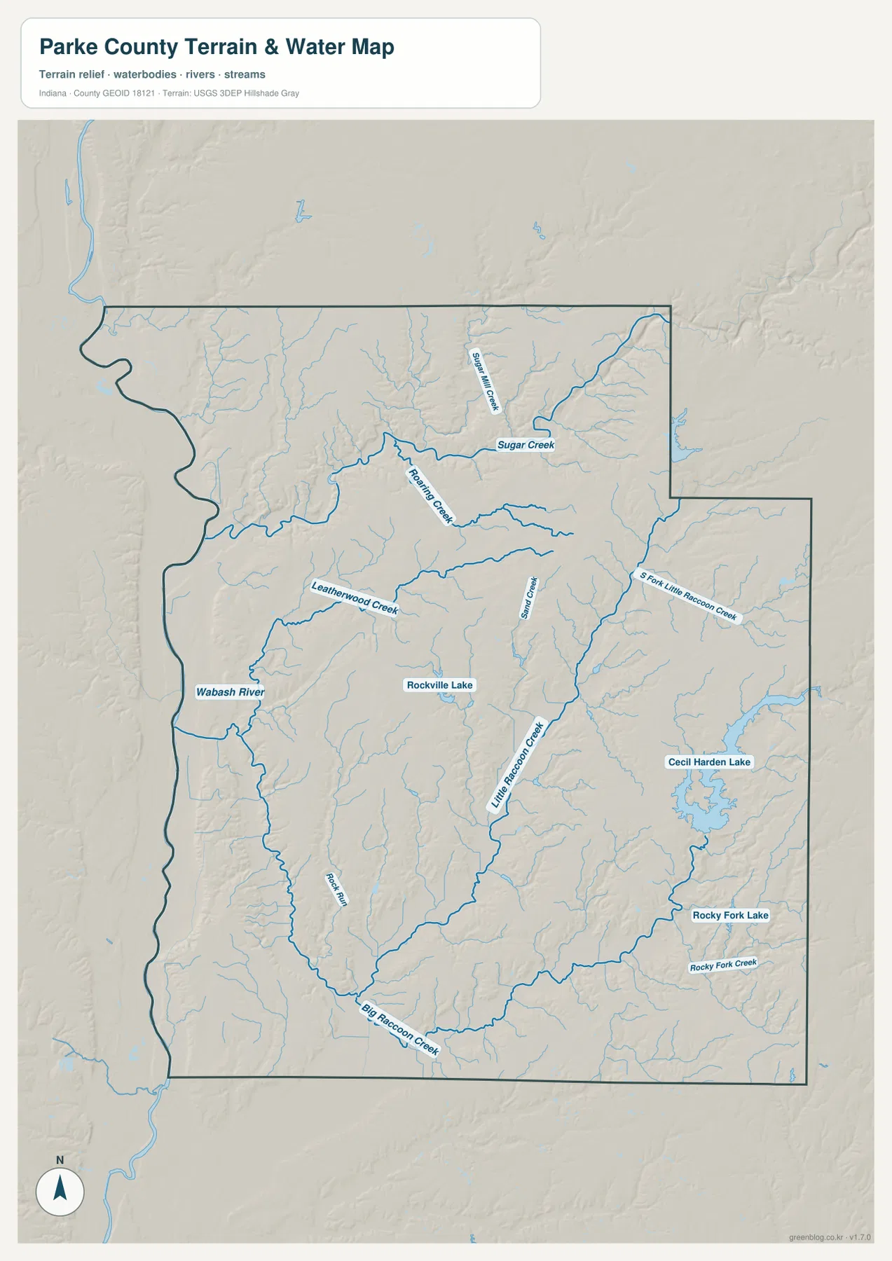
Little Raccoon Creek runs through the central and southeastern interior, while Big Raccoon Creek forms a strong east–west line across the south. Sand Creek provides another central tributary reference. Rocky Fork Creek and Rocky Fork Lake appear farther east, adding smaller fixed landmarks within terrain that is otherwise heavily divided by narrow valleys.
Cecil M. Harden Lake occupies the southeastern part of the county and was created by damming Big Raccoon Creek. Indiana DNR manages the reservoir with Raccoon State Recreation Area and describes the upper creek country as forested hills and hollows. On this page, the water image is meant for geographic orientation and terrain comparison. Flood conditions, current lake levels, navigation rules, property limits, and legal water boundaries require current agency information.
The 140–256 m relief rises sharply from the Wabash flats into eastern and northeastern ridges
The elevation legend gives an actual Parke County range of about 140 to 256 meters and a mean of 196 meters. The Wabash River corridor appears as the widest low green zone. Moving east from that boundary, the surface climbs through lighter green and yellow into increasingly frequent tan and brown ridges, especially toward the eastern and northeastern county.
Sugar Creek forms a deeply cut northern corridor. Roaring Creek and numerous smaller tributaries create branching green valleys through surrounding higher ground, producing a compact ridge-and-ravine texture. This topography helps explain why the Turkey Run area is known for steep ravines even though the county’s absolute elevations are not mountainous.
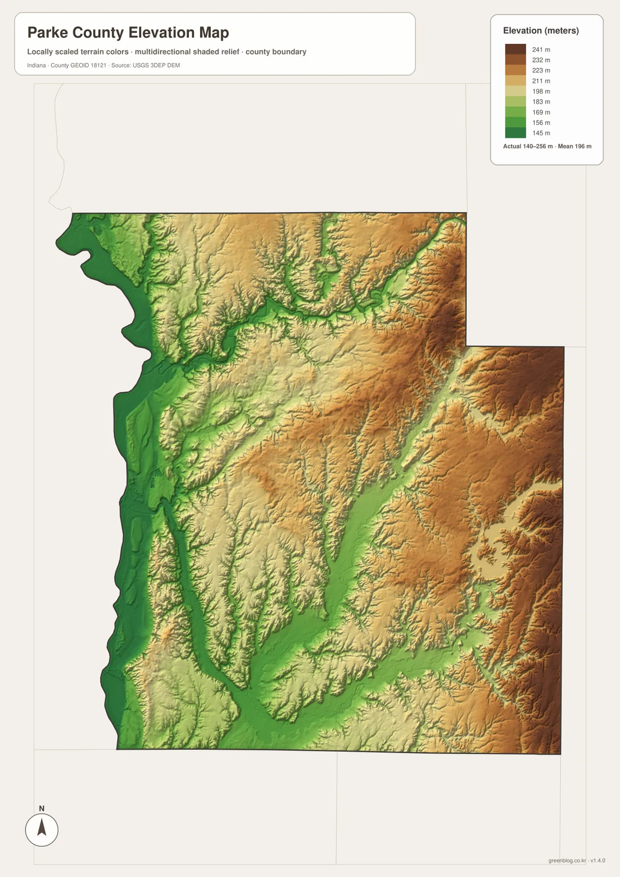
Rockville sits within middle-elevation rolling terrain cut by several creek valleys. West of town, the land drops toward the Wabash River. Eastward toward Cecil M. Harden Lake and the northeastern county, the ridges become higher and more tightly spaced. Big Raccoon Creek cuts a long southern low corridor through this higher surface, making the creek easy to follow on the elevation image.
This county-scale relief is useful for comparing the western river plain with the more broken interior, but it is not a survey surface. For a Parke County parcel, building site, roadway grade, or drainage project, consult original USGS elevation data or a qualified survey instead of relying on this generalized image.
Keep Rockville fixed while comparing the Wabash, Sugar Creek, and Cecil M. Harden Lake
For roads and settlements, begin with Rockville and State Road 36. Move west to Montezuma and Mecca, south to Rosedale, and north to Bloomingdale and Marshall. Routes 41, 47, 59, 236, and 234 then provide a simple framework for the outer county and make the smaller place labels easier to locate.
The city index is useful when the goal is to compare the six highlighted communities without the dense road and creek network. Rockville clearly dominates the printed values, while the other towns act as directional references. For Bridgeton, Judson, Lyford, or exact road relationships, return to the general map.
For physical geography, locate Wabash River first, then Sugar Creek in the north and Big Raccoon Creek in the south. Add Cecil M. Harden Lake in the southeast and switch to the elevation view at those same locations. The main pattern becomes clear: broad western lowlands, deeply cut creek valleys, and stronger ridges toward the east and northeast.
The WebP images are reduced for quick page viewing. The Parke County download contains four original 2572×3638-pixel JPG files for the general map, city index, terrain-and-water map, and elevation map. Use the larger originals when small road shields, creek labels, reservoir outlines, or hill shading need to stay legible in print.
A useful comparison is to keep Rockville fixed as the central reference. Find Montezuma, Mecca, and Rosedale on the general map, compare the six highlighted places on the city index, move to the water view to trace Wabash River and Sugar Creek, and finish on the elevation image by comparing the western flats with the higher eastern ridges.
Frequently Asked Questions
What is the county seat of Parke County?
Parke County’s official government site identifies Rockville as the county seat. On the supplied map, Rockville is the largest central settlement and sits where State Road 36 connects with several routes leading west, south, and east.
Which water features are easiest to recognize?
Wabash River forms the western boundary, Sugar Creek crosses the north, and Big Raccoon Creek spans the lower county. Cecil M. Harden Lake is the largest mapped lake, with Rockville Lake and Rocky Fork Lake providing smaller landmarks. The water image is for geographic reference rather than flood, parcel, or legal-boundary decisions.
Can the 140–256 m elevation range be used for exact site measurements?
No. The elevation image gives a county-wide range with a mean of 196 meters and is intended for comparing the Wabash River lowlands with creek valleys and higher eastern ridges. For precise elevation on a Parke County parcel, building site, road grade, or drainage project, use original terrain data or a qualified survey rather than this county-scale image.
Map File Information
The Parke County ZIP combines the general road-and-place map, six-place city index, terrain-and-water map, and elevation map as full-resolution JPG originals.
- File Type: ZIP containing four 2572×3638px JPG files
Related Maps
Sources and References
The article is based primarily on the supplied Parke County map set and asset manifest. The following official sources provide county, Rockville, Turkey Run, Cecil M. Harden Lake, boundary, hydrography, and elevation context.
- Parke County, Indiana – official county government information, including Rockville as the county seat
- Indiana DNR – Turkey Run State Park – official information on Sugar Creek, sandstone ravines, and northern Parke County terrain
- Indiana DNR – Cecil M. Harden Lake (Raccoon SRA) – official context for Big Raccoon Creek, the reservoir, and surrounding hills
- U.S. Census Bureau TIGER/Line Shapefiles – boundary reference for Parke County and its place framework
- USGS National Hydrography – reference data for Wabash River, Sugar Creek, Raccoon Creek, and mapped water features
- USGS 3D Elevation Program – source terrain data for detailed elevation work beyond the county-scale relief image
Green Map creates custom-edited map images using open geographic data sources such as geoBoundaries, Natural Earth, OpenStreetMap, and government open data.
These maps are edited visual materials, not raw data files, and are provided for education, documents, presentations, and graphic reference.