Madison County is organized around Anderson in the south-central part of the county, with Elwood and Alexandria providing northern references and Pendleton, Lapel, and Ingalls spreading across the south. You can download the high-resolution JPG ZIP directly from this page when you need larger road labels, creek names, city details, or relief shading. This Madison County Indiana Map page combines the Anderson road network with the six-place city index, White River and the Pipe–Killbuck creek systems, and a 202–310 meter elevation surface that rises noticeably toward the east and southeast.
Anderson is the easiest place to use for orientation. It has the largest developed footprint and sits near Routes 9, 32, and 67, with Edgewood immediately to the north and Chesterfield to the east. Alexandria is farther north along the Route 9 side, Elwood occupies the northwest, and Pendleton provides the strongest southern town reference. Lapel and Ingalls help define the southwest, while Markleville reaches toward the southeastern edge.
The terrain map changes the visual balance of the county. Its legend gives an actual range of about 202 to 310 meters and a mean of 268 meters. White River and several creeks occupy long low green corridors through the center and east. The western and central parts remain relatively low overall, while the eastern half rises and the strongest high ground appears in the southeast.
Table of Contents
Anderson anchors the road network between the northern towns and Pendleton
Anderson is the dominant developed area on the general map. Community Hospital Anderson, the Madison County Government Center, and Ivy Tech Community College Anderson are all labeled within or near the city, making its footprint easy to identify. Route 9 runs north-south through the area, while Routes 32 and 67 create strong east-west references. Once Anderson is located, the nearby towns fall into a much clearer pattern.
Edgewood sits immediately north of Anderson, and Chesterfield lies to the east along the Route 32 side. Continuing north brings Alexandria into view, with Orestes farther west and Summitville close to the northeastern boundary. This Anderson–Alexandria–Summitville sequence is a useful way to organize the eastern half without trying to remember every local road number.
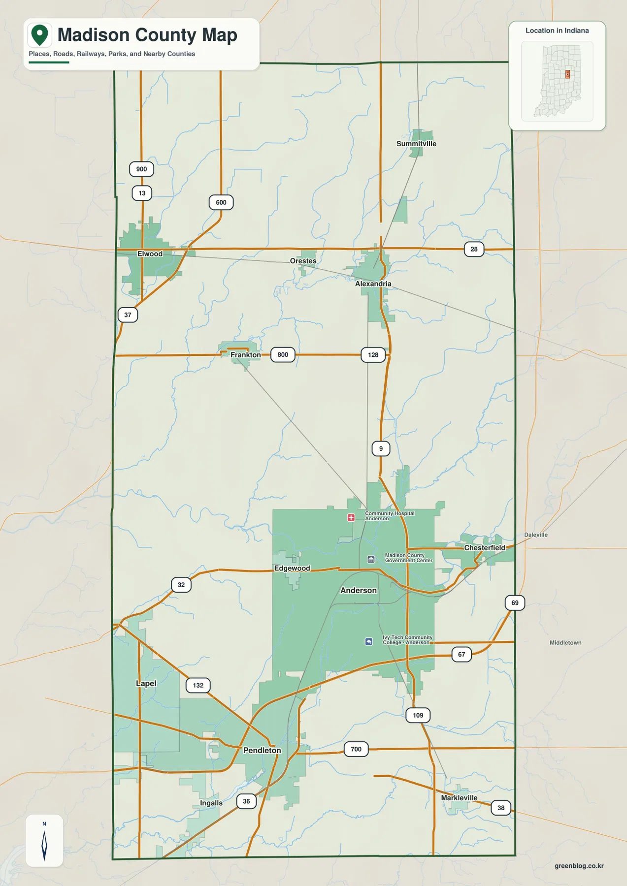
Elwood forms a separate northwestern center. Route 28 continues east from the Elwood area toward Orestes and Alexandria, while Routes 37 and 13 provide western and northern references. Frankton appears farther south near the 800-road line, helping fill the large gap between Elwood and Anderson. The northwest has much less continuous development than the Anderson area, but it remains well connected by the road grid.
Pendleton is the clearest southern town. Routes 9 and 109 approach from the Anderson side, and several roads branch around Pendleton, including 36, 700, and 132. Lapel lies farther west and Ingalls southwest of Pendleton, while Markleville sits near the southeastern side on Route 38. Using Pendleton as a hub makes the lower third of the county much easier to navigate.
The city index shows Anderson far ahead of five smaller centers around the county
The supplied city index highlights six places. Anderson is printed at 55,367, Elwood at 8,356, Pendleton at 5,321, Alexandria at 5,155, Lapel at 2,668, and Ingalls at 2,512. These figures belong to the supplied map edition rather than a live demographic feed. Their geographic value is more important here: Anderson clearly dominates the south-central area, while the other five cities provide reference points in the northwest, northeast, and southern corners.
| Rank | Place | Value printed on map | Position |
|---|---|---|---|
| 1 | Anderson | 55,367 | South-central |
| 2 | Elwood | 8,356 | Northwest |
| 3 | Pendleton | 5,321 | South-central |
| 4 | Alexandria | 5,155 | Northeast-central |
| 5 | Lapel | 2,668 | Southwest |
| 6 | Ingalls | 2,512 | South / west of Pendleton |
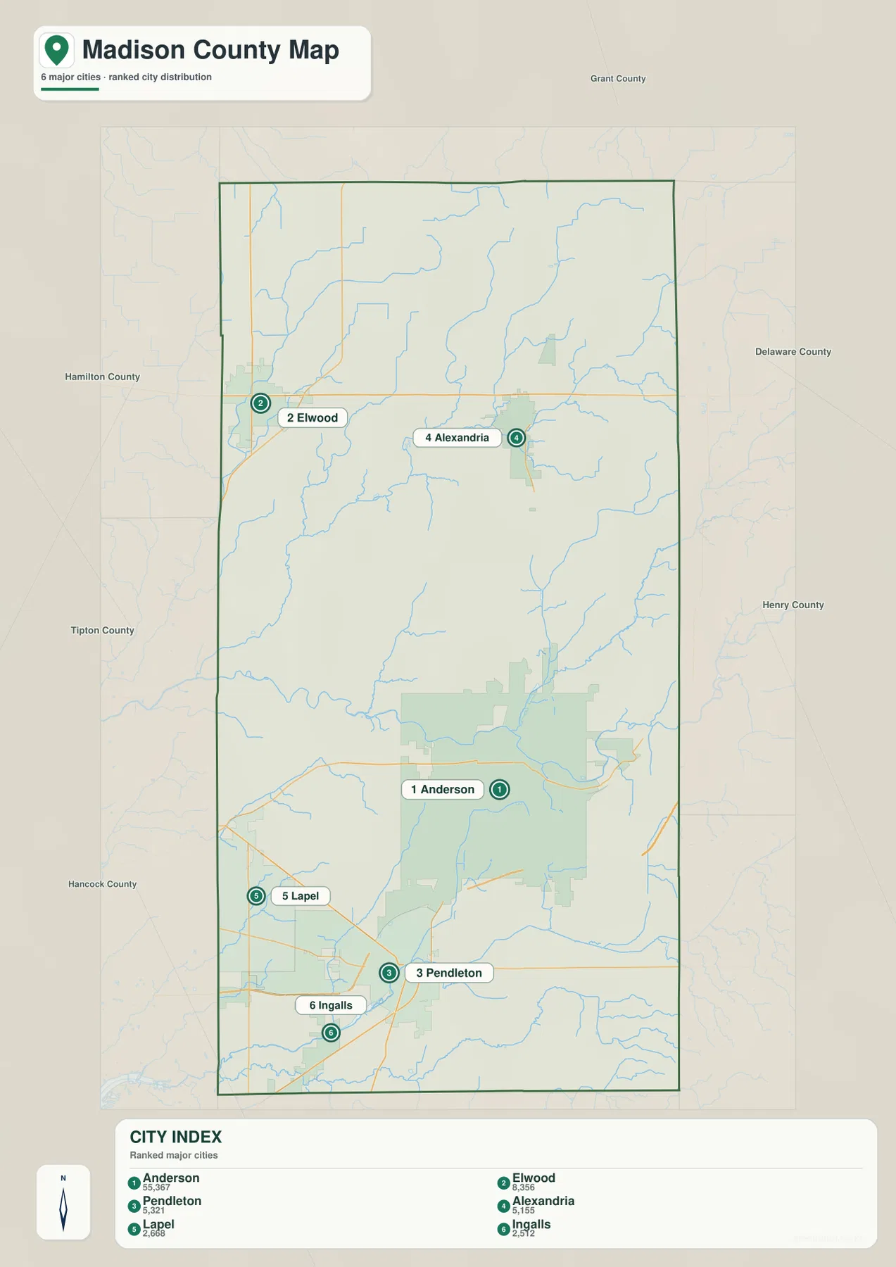
Anderson and Pendleton are relatively close on the lower half of the map, yet the printed index shows a very large difference in scale. Elwood is isolated in the northwest, and Alexandria provides a second northern reference on the opposite side. Lapel and Ingalls help show that the southwest remains settled even though it does not have a city footprint comparable with Anderson.
The general map adds several places that do not appear in the six-place index, including Edgewood, Chesterfield, Summitville, Frankton, Orestes, and Markleville. Use the general view when those smaller places or road connections matter. The index is better when you want a stripped-down comparison of the six highlighted centers. Current population work should rely on a current official source rather than the printed index values.
White River crosses the center while Pipe and Killbuck creeks shape the northern and eastern valleys
White River is the strongest water reference on the terrain-and-water map. It enters from the west, bends broadly through the central-lower county, passes the Anderson side, and continues toward the eastern boundary. The same corridor is easy to recognize on the elevation image because it remains lower and greener than the surrounding land.
Pipe Creek creates a long northern corridor, while Mud Creek occupies the northeastern interior. Little Duck Creek and Big Duck Creek provide separate northwestern channels. Around the Pipe Creek system, many smaller tributaries merge into a broad network rather than one simple straight channel, which explains the dense pattern of blue lines across the northern half.
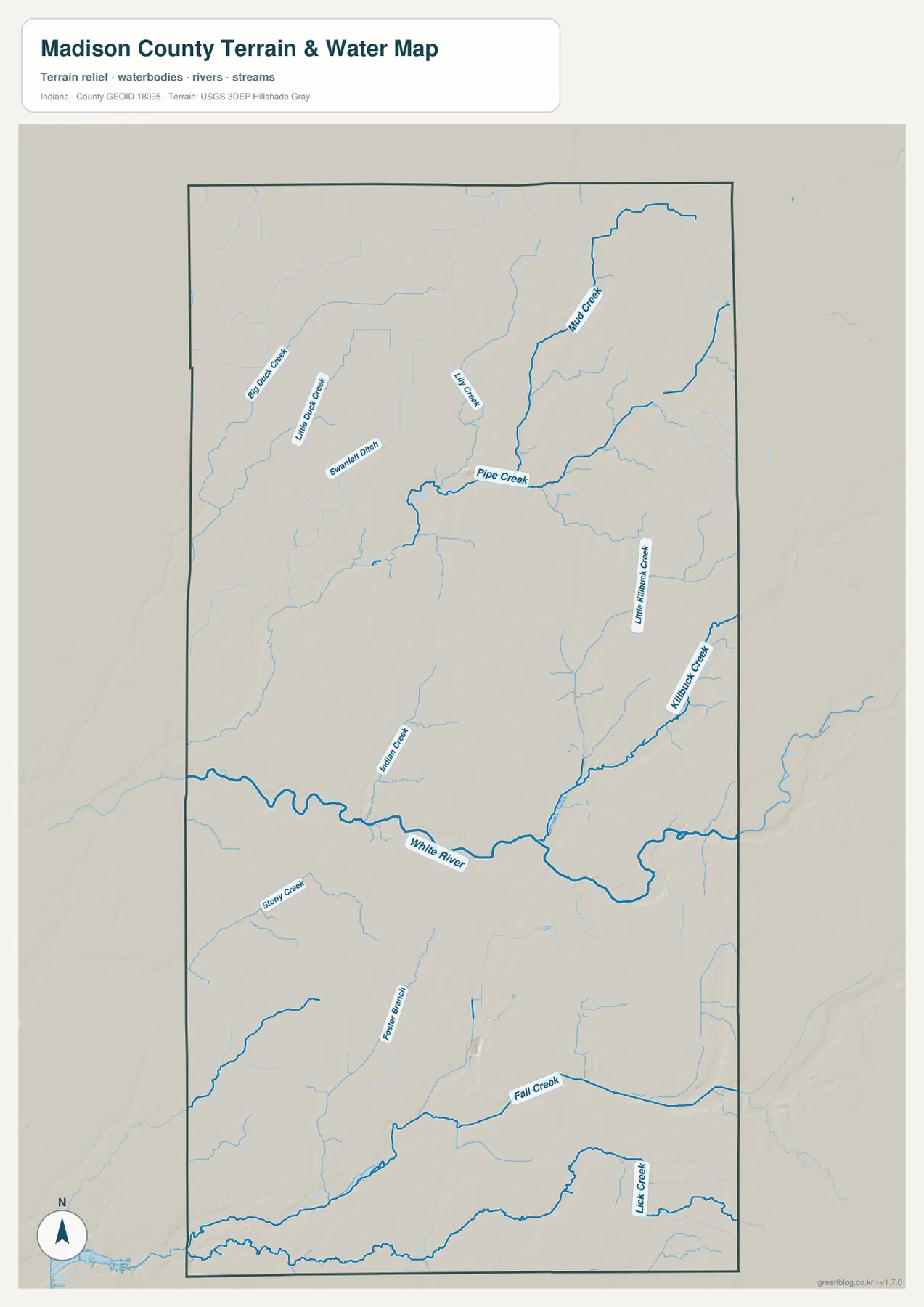
Killbuck Creek is the clearest eastern drainage line, and Little Killbuck Creek joins the same broad valley system from the west. Indiana IDEM’s Upper White River Watershed plan includes Madison County and Anderson and identifies Killbuck Creek as one of the watershed’s major subareas. That official watershed context helps explain why the eastern drainage stands out so clearly on the supplied county map.
Fall Creek crosses the southern part of the county, while Lick Creek occupies the southeast and Foster Branch drains part of the south-central interior. The terrain around these streams differs from the broad lowland in the west: lower creek cuts sit next to increasingly high ground toward the southeastern boundary.
Mounds State Park provides a useful real-world White River reference east of Anderson. Indiana DNR notes that one of the park’s trails follows the White River and limestone bluffs. The county water map here is still a geographic reference rather than a flood, navigation, legal-boundary, or current-water-condition product, so those questions require the appropriate current agency source.
The 202–310 m elevation surface rises from the White River lowland toward the southeast
The elevation legend gives an actual Madison County range of about 202 to 310 meters and a mean of 268 meters. Greens represent lower terrain, and yellow through brown marks progressively higher ground. Much of the west and center remains relatively low. The east rises gradually, and the strongest high ground occupies the southeastern corner.
White River is easy to follow as a long low corridor. Its broad bends create a green band across the middle-lower county, and the land rises away from that channel. Pipe Creek and Mud Creek create similar but narrower low lines in the north. The contrast is especially clear where tributaries cut into the higher eastern surface.
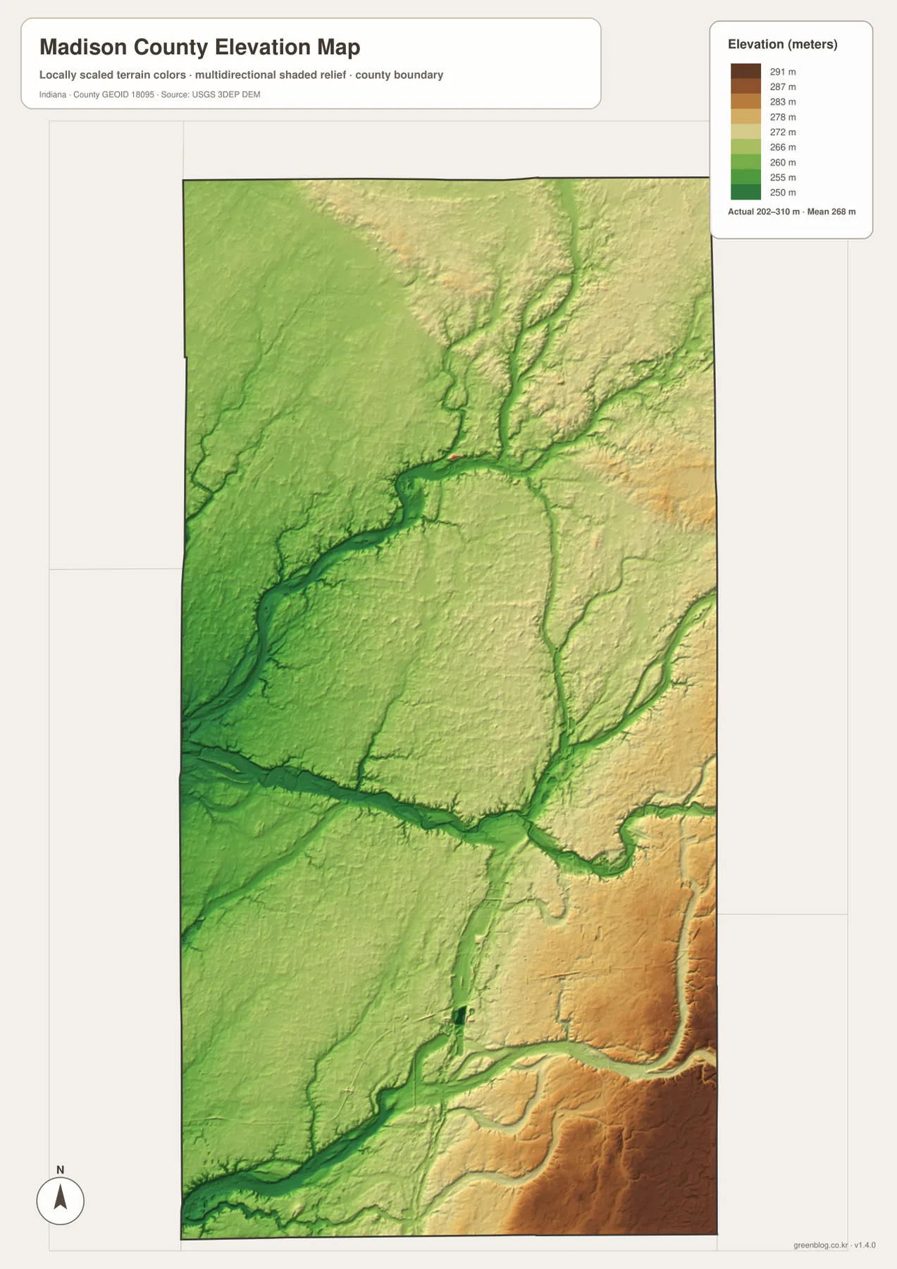
The eastern half is not one flat upland. Killbuck Creek and Little Killbuck Creek cut long green channels through higher yellow and tan terrain. The northeast contains broad moderate high ground, while the southeast becomes darker and more elevated. This creates a repeated ridge-and-valley pattern even though Madison County does not have mountain-scale relief.
Around Pendleton and Fall Creek, lower terrain extends through the south, but the ground rises quickly toward Markleville and the southeastern boundary. A useful first reading is to separate the west-central lowland, the White River corridor, the rising east, and the southeastern high ground before looking at individual tributary valleys.
The 202–310 meter legend summarizes county-scale relief, not a surveyed elevation for a parcel, building site, road grade, or drainage plan. Exact site work should use original elevation data such as the USGS 3D Elevation Program or measurements from a qualified survey. The supplied image is best used to compare river lowlands, creek valleys, and the higher eastern terrain.
Start with Anderson, then compare the city pattern with White River and the southeastern rise
For roads and settlements, begin at Anderson near Routes 9, 32, and 67. Move northwest to Elwood, northeast to Alexandria, and south to Pendleton before adding Lapel, Ingalls, and Markleville. The detailed general map is also the best place to find smaller names such as Edgewood, Chesterfield, Summitville, Frankton, and Orestes.
The city index is useful when the goal is to compare only the six highlighted centers. Anderson dominates the printed values, Elwood marks the northwest, Alexandria the northeast, and Pendleton, Lapel, and Ingalls define the southern half. For current demographic totals, use a current official statistical source instead of treating the printed values as live population data.
For physical geography, locate White River first and then add Pipe Creek, Mud Creek, and Killbuck Creek. Switch to the elevation map at those same locations and the relationship becomes clear: the waterways occupy lower corridors, while the land rises toward the east and reaches its strongest elevation in the southeast. Fall Creek provides a final southern comparison around the Pendleton side.
The WebP images on this page are reduced previews. The ZIP below contains four original 2572×3638-pixel JPG files: the general county map, city index, terrain-and-water map, and elevation map. The larger originals are better for printing or reading small road, creek, and place labels.
A practical comparison is to keep Anderson fixed as the reference point. Find Alexandria and Pendleton on the general map, compare their scale on the city index, move to the water view to trace White River and the Pipe–Killbuck creek systems, and finish on the elevation map by comparing those low corridors with the southeastern high ground. That sequence connects settlement, drainage, and terrain without requiring every local road or tributary to be memorized.
Frequently Asked Questions
Which places have the largest values on the supplied city index?
Anderson is printed at 55,367, followed by Elwood at 8,356, Pendleton at 5,321, Alexandria at 5,155, Lapel at 2,668, and Ingalls at 2,512. These figures belong to the supplied map edition rather than a live statistical feed.
Which waterways are easiest to recognize?
White River is the strongest central reference. Pipe Creek and Mud Creek organize the north, Killbuck Creek and Little Killbuck Creek mark the east, and Fall Creek crosses the south. The map shows geographic position and terrain relationships rather than flood status, current water conditions, or legal boundaries.
Can the 202–310 m elevation range be used for exact site elevations?
No. The elevation image gives a county-wide range with a mean of 268 meters and is intended for comparing White River and creek lowlands with the higher eastern and southeastern terrain. For a Madison County parcel, building site, drainage plan, or road-grade question, use original terrain data or a qualified survey instead of this county-scale elevation image.
Map File Information
The Madison County ZIP combines the general road-and-place map, six-place city index, terrain-and-water map, and elevation map as full-resolution JPG originals.
- File Type: ZIP containing four 2572×3638px JPG files
Related Maps
Sources and References
The article is based primarily on the supplied Madison County map set and asset manifest. The following official sources provide county, White River, Mounds State Park, boundary, hydrography, and elevation context.
- Madison County, Indiana – official county government information
- Indiana DNR – Mounds State Park – official White River and park context east of Anderson
- Indiana IDEM – Upper White River Watershed – watershed context including Madison County, Anderson, and Killbuck Creek
- U.S. Census Bureau TIGER/Line Shapefiles – county-boundary and geographic reference data
- USGS National Hydrography – river and creek reference data
- USGS 3D Elevation Program – source terrain data for precise elevation work
Green Map creates custom-edited map images using open geographic data sources such as geoBoundaries, Natural Earth, OpenStreetMap, and government open data.
These maps are edited visual materials, not raw data files, and are provided for education, documents, presentations, and graphic reference.