LaGrange County is organized around the central town of LaGrange, with Shipshewana to the west, Topeka to the southwest, Howe and Ontario to the north, and Mongo toward the northeast. You can download the high-resolution JPG ZIP directly from this page when you need to inspect small road shields, lake names, stream labels, or relief shading. This LaGrange County Map page combines the road network with direct city distances, the Fawn and Pigeon river systems, a dense group of southern lakes, and an elevation surface that rises markedly toward the eastern side.
LaGrange and U.S. 20 provide the simplest starting point. U.S. 20 runs west toward Shipshewana and east across the county, while State Road 9 approaches LaGrange from Howe and continues south toward Wolcottville. State Road 5 helps place Shipshewana and Topeka in the west, and State Road 3 provides an eastern reference near South Milford. Mongo, Stroh, and Wildwood help define the far eastern and southeastern side.
The physical map adds a very different layer. Fawn River and Pigeon River cross the north, while Fish, Oliver, Dallas, Witmer, Adams, Pretty, Big Long, and Shipshewana lakes create numerous water landmarks farther south and west. The elevation legend gives an actual county range of about 247 to 327 meters and a mean of 279 meters. Broad low ground dominates the west and northwest, whereas the east and southeast contain much stronger hills and ridge relief.
Table of Contents
LaGrange and Shipshewana make the central and western road network easy to follow
The general map places LaGrange near the center of the county and labels both the LaGrange Police Department and LaGrange County Sheriff Department nearby. U.S. 20 crosses the town from west to east, while State Road 9 runs down from the Howe area before continuing toward Wolcottville. Those two roads create the clearest central framework for finding the rest of the county.
Shipshewana lies west of LaGrange near State Road 5 and U.S. 20. Shipshewana Lake is just north of the community, giving the western side an easy water landmark as well as a road reference. Topeka is farther south along the State Road 5 side. The three communities are separated by open rural areas rather than one continuous developed corridor.
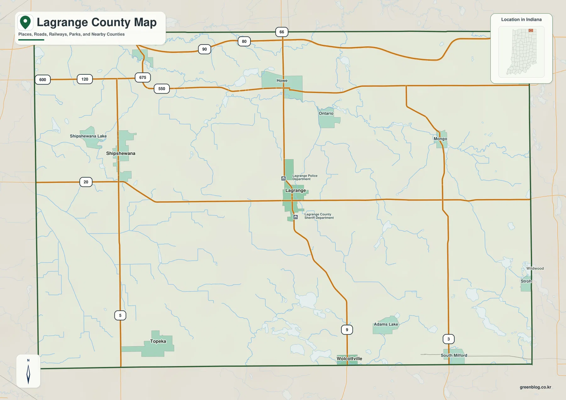
Howe and Ontario provide northern reference points. Howe sits close to the State Road 9 line and the 120/550 road area, while Ontario lies farther east. Mongo is the strongest named place near the northeastern side and is close to the State Road 3 corridor. Roads 80, 90, and 66 appear beyond the top edge and help separate the county road network from routes just outside the boundary.
The southern half is easier to understand by using Topeka, Wolcottville, and South Milford as three separate anchors. Topeka is in the southwest, Wolcottville near the south-central edge, and South Milford in the southeast. Adams Lake sits between the latter two areas, while Stroh and Wildwood appear close to the eastern boundary. Because lakes become more numerous here, the water map is especially helpful for confirming location.
The city-connections map compares Shipshewana and Topeka directly with LaGrange
The supplied city-connections map uses LaGrange as its hub and highlights Shipshewana and Topeka. The printed index values are 2,790 for LaGrange, 1,137 for Topeka, and 822 for Shipshewana. These numbers belong to the supplied map edition rather than a live demographic feed. The most useful information here is the geometry: Shipshewana lies west of LaGrange and Topeka lies southwest, with similar direct distances.
| Map rank | Place | Value printed on map | Straight-line distance from LaGrange | Direction |
|---|---|---|---|---|
| 1 | LaGrange | 2,790 | Hub | Central |
| 2 | Topeka | 1,137 | 10 mi | Southwest |
| 3 | Shipshewana | 822 | 9 mi | West |
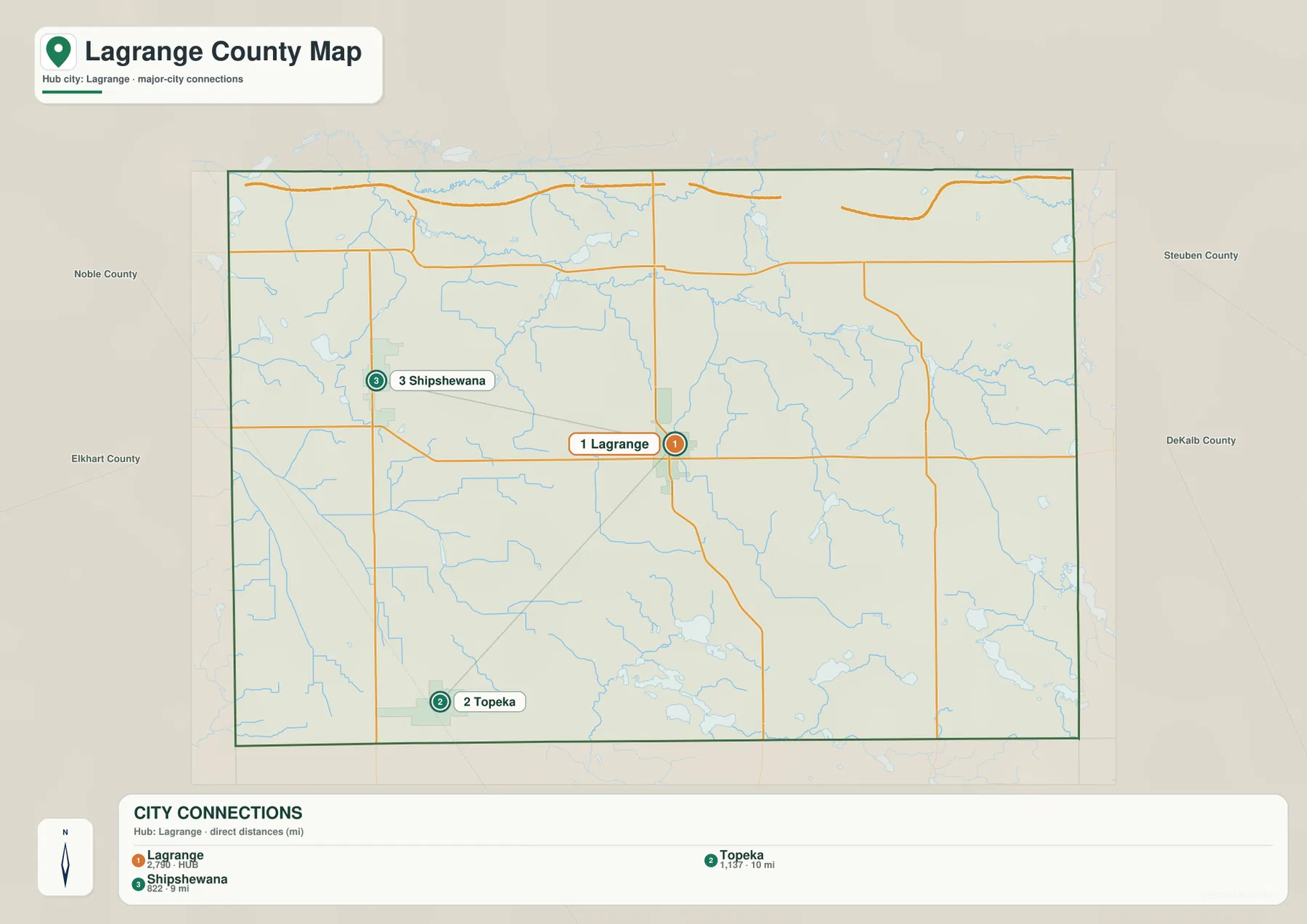
The 9- and 10-mile labels are straight-line measurements between mapped place points. They are not driving distances, so a road trip may cover a different number of miles depending on the selected route and the exact starting and ending locations. The general map remains the better view when the route itself matters.
This connector graphic is intentionally selective. It does not describe traffic volume, commuting areas, municipal boundaries, or every community in the county. Howe, Mongo, Wolcottville, South Milford, and other named places remain available on the more detailed general map.
Fawn and Pigeon rivers cross the north while a chain of lake landmarks fills the south
Fawn River is the uppermost major water line on the terrain-and-water map, winding close to the northern county boundary. Pigeon River runs farther south on a long east-west course. Numerous smaller channels and water bodies occupy the space around them, so the northern drainage is more intricate than a pair of isolated rivers.
South of Pigeon River, Buck Creek and Fly Creek become useful internal references. Buck Creek approaches the Pigeon River system from the northwest-central area, while Fly Creek extends much farther south through the middle of the county. Little Elkhart River bends across the southwest, and Pope-Eden Ditch appears farther south. Using the two northern rivers first makes these smaller channels much easier to place.
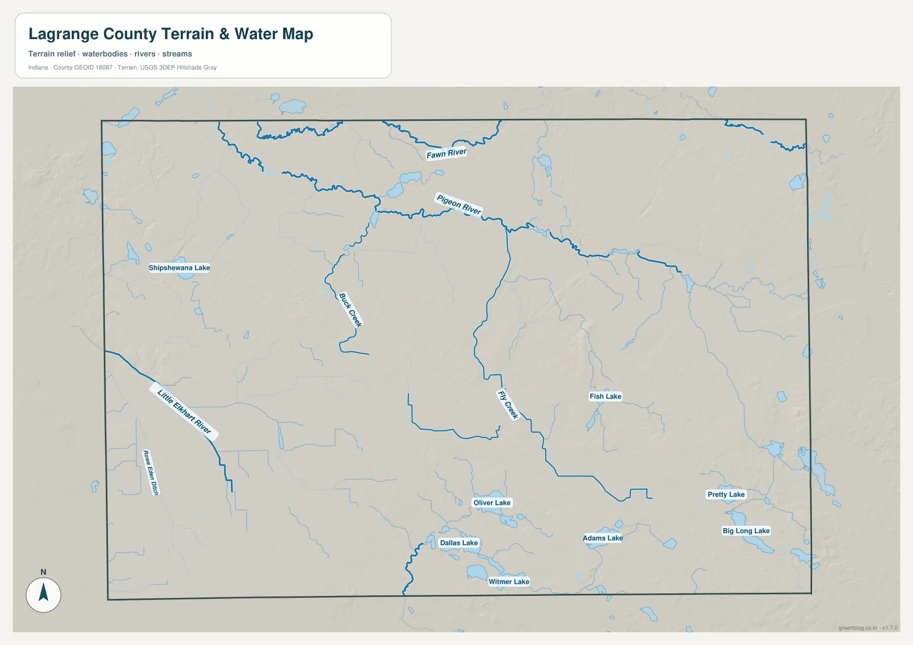
The southern half is easier to navigate by lake names. Fish Lake lies east of center, Oliver Lake farther south, and Dallas and Witmer lakes sit close together near the lower middle of the map. Adams Lake is farther east, while Pretty Lake and Big Long Lake occupy the southeastern side. Shipshewana Lake provides another distinctive landmark in the west.
Indiana DNR’s lake association directory separately lists several of the waters visible here, including Big Long, Dallas, Oliver, Pretty, and Witmer lakes in LaGrange County. That official directory is useful confirmation of how strongly lakes shape the county’s southern geography. The supplied map itself is for location and terrain reference; it does not establish flood zones, legal water limits, navigation rights, current lake levels, or water-quality conditions.
The 247–327 m elevation surface rises from western low ground into the eastern and southeastern hills
The elevation legend gives an actual LaGrange County range of about 247 to 327 meters and a mean of 279 meters. Greens mark lower terrain, while yellow, tan, and brown identify progressively higher ground. The broadest low surface occupies the west and northwest. The eastern and southeastern parts of the county contain the most prominent hills and ridge groups.
The northwestern half includes a few locally raised patches, but the Fawn and Pigeon river corridor is mostly lower and greener than the eastern uplands. Shipshewana and the western lake area also sit within gentler terrain compared with the high ridge clusters farther east. This difference is visible even before individual creek valleys are traced.
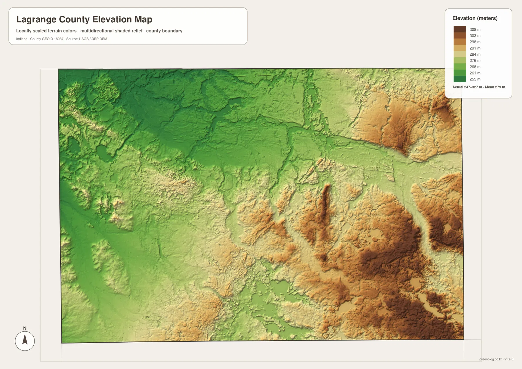
The eastern side contains several abrupt local rises. High brown terrain appears in the northeast and again across the east-central and southeastern sections. Fish Lake and Adams Lake occupy lower depressions within or beside these higher areas, which makes the contrast between lake basins and surrounding hills easy to see.
Pretty Lake and Big Long Lake provide a similar example in the southeast. The water bodies sit in lower basins, while tan and brown terrain rises nearby. LaGrange County therefore should not be reduced to a flat “lake district”: a more accurate county-scale picture includes western lowlands, northern river flats, eastern hills, and numerous lake basins embedded within those terrain zones.
The 247–327 meter range is a generalized county relief surface. It is suitable for comparing broad low and high areas, but it is not a survey-grade elevation for a parcel, foundation, road grade, or drainage design. Exact site work should use source elevation data such as the USGS 3D Elevation Program or professional survey measurements.
Start with LaGrange, then use the rivers and southern lakes to orient the terrain views
For roads and settlements, begin at LaGrange and U.S. 20. Place Shipshewana to the west, Howe to the north, Mongo to the northeast, and then follow State Roads 9, 5, and 3 toward the southern communities. Topeka, Wolcottville, and South Milford provide a simple three-point framework for the lower half.
The connector map is the fastest way to compare LaGrange with Shipshewana and Topeka. It shows direct distances of roughly 9 and 10 miles, respectively. Those measurements are geometric rather than route miles, so driving plans should use current road directions instead.
For physical geography, locate Fawn River and Pigeon River first and then move south to Fish, Oliver, Dallas, Witmer, Adams, Pretty, and Big Long lakes. Switching to the elevation view at those same positions shows how the western lowlands give way to stronger eastern relief and how individual lakes occupy lower basins within the hill country.
The WebP images on this page are reduced previews. The download archive contains four original 3638×2572-pixel JPG files: the general county map, city-connections map, terrain-and-water map, and elevation map. The full-size versions are the better choice for printing or for reading small road and water labels.
A practical comparison is to keep LaGrange fixed as the reference point. Use the road map to find Shipshewana and Topeka, check their direct spacing on the connector map, move to the water map to trace Pigeon River and the southern lakes, and finish with the relief map to compare the low western side with the eastern hills. The same sequence works well from Mongo or South Milford if your interest is the eastern half.
Frequently Asked Questions
How far are Shipshewana and Topeka from LaGrange on the connector map?
The supplied graphic places Shipshewana about 9 miles west of LaGrange and Topeka about 10 miles southwest. Both are straight-line distances between mapped place points, not road-driving distances, so actual travel mileage varies with the chosen route.
Which water features are easiest to recognize?
Fawn River and Pigeon River are the strongest northern references. In the southern half, Fish, Oliver, Dallas, Witmer, Adams, Pretty, and Big Long lakes provide distinctive landmarks, while Shipshewana Lake helps orient the west. The map shows location rather than flood status, legal water boundaries, or current lake conditions.
Can the 247–327 m elevation range be used for exact site measurements?
No. The elevation image gives a county-wide relief range with a mean of 279 meters and is intended for comparing western low ground, river flats, lake basins, and eastern hills. Parcel, construction, drainage, or engineering work requires source elevation data or professional survey measurements.
Map File Information
The LaGrange County ZIP combines the general road-and-place map, city-connections map, terrain-and-water map, and elevation map as full-resolution JPG originals.
- File Type: ZIP containing four 3638×2572px JPG files
Related Maps
Sources and References
The article is based primarily on the supplied LaGrange County map set and asset manifest. The following official sources provide local parks-and-lakes, nature-preserve, boundary, and elevation context.
- Town of LaGrange – Local Organization Links – local references including LaGrange County Parks and Recreation
- Indiana DNR Lake Association Directory – official directory covering several LaGrange County lakes
- Indiana DNR Nature Preserves – official listings including Fawn River and LaGrange County preserves
- U.S. Census Bureau TIGER/Line Shapefiles – boundary and geographic reference data
- USGS 3D Elevation Program – source elevation data
Green Map creates custom-edited map images using open geographic data sources such as geoBoundaries, Natural Earth, OpenStreetMap, and government open data.
These maps are edited visual materials, not raw data files, and are provided for education, documents, presentations, and graphic reference.