Dearborn County occupies Indiana’s southeastern corner, where riverfront communities sit beside a landscape cut by narrow valleys and steep ridges. Lawrenceburg, Greendale, and Aurora cluster near the Ohio River, while St. Leon lies near the northern edge and Dillsboro and Moores Hill anchor the western side. The general map combines those places with major roads and the county boundary, while the terrain-and-water map makes the Ohio River, Whitewater River, Tanners Creek, and smaller valley systems much easier to follow. After exploring the roads, communities, waterways, and elevation below, you can download the same map set as high-resolution JPG files in one ZIP archive.
A useful way to understand the county is to begin at Lawrenceburg on the river and then look inland. Greendale sits immediately northwest of Lawrenceburg, and Aurora follows the river southwest. Away from that southeastern cluster, the settlement pattern opens up: St. Leon stands well to the north, Moores Hill is west of the center, and Dillsboro is farther southwest. The change in settlement density matches a change in terrain. Broad low ground follows the major river valleys, while the interior is divided by many higher ridges and narrow stream corridors.
The elevation map places the county between about 138 and 317 meters, with a mean near 244 meters. Low green bands trace the Ohio River and several tributary valleys, but higher orange and brown ground occupies much of the west and northwest. In the center and east, the colors change quickly because creeks have carved deep, branching valleys into the uplands. That repeated contrast between low water corridors and higher ridges is one of the clearest geographic signatures of Dearborn County.
Table of Contents
Lawrenceburg and Aurora form the main riverfront road cluster
The general county map draws attention first to Lawrenceburg. The city sits along the eastern edge close to the Ohio River, and the Dearborn County Circuit Courthouse is marked there. Greendale is directly northwest, creating the most concentrated built-up area shown on the map. Aurora lies southwest along the river corridor, while Hidden Valley, Bright, and West Harrison occupy the eastern and northeastern side. St. Leon is separate from that cluster near the northern boundary, making it a useful landmark for judging the full north-south extent of the county.
The road pattern is easiest to read by using those communities as anchors rather than trying to memorize every route number. Around Lawrenceburg and Greendale, Route 275 is visible near the riverfront. Aurora is connected to Routes 148 and 56, and Route 1 runs northward through the interior toward the St. Leon area. Routes 46 and 52 cross the northern part of the county. Farther west, Routes 48 and 350 serve the Manchester and Moores Hill area, while Routes 50, 62, and 262 appear around Dillsboro and the southwest.
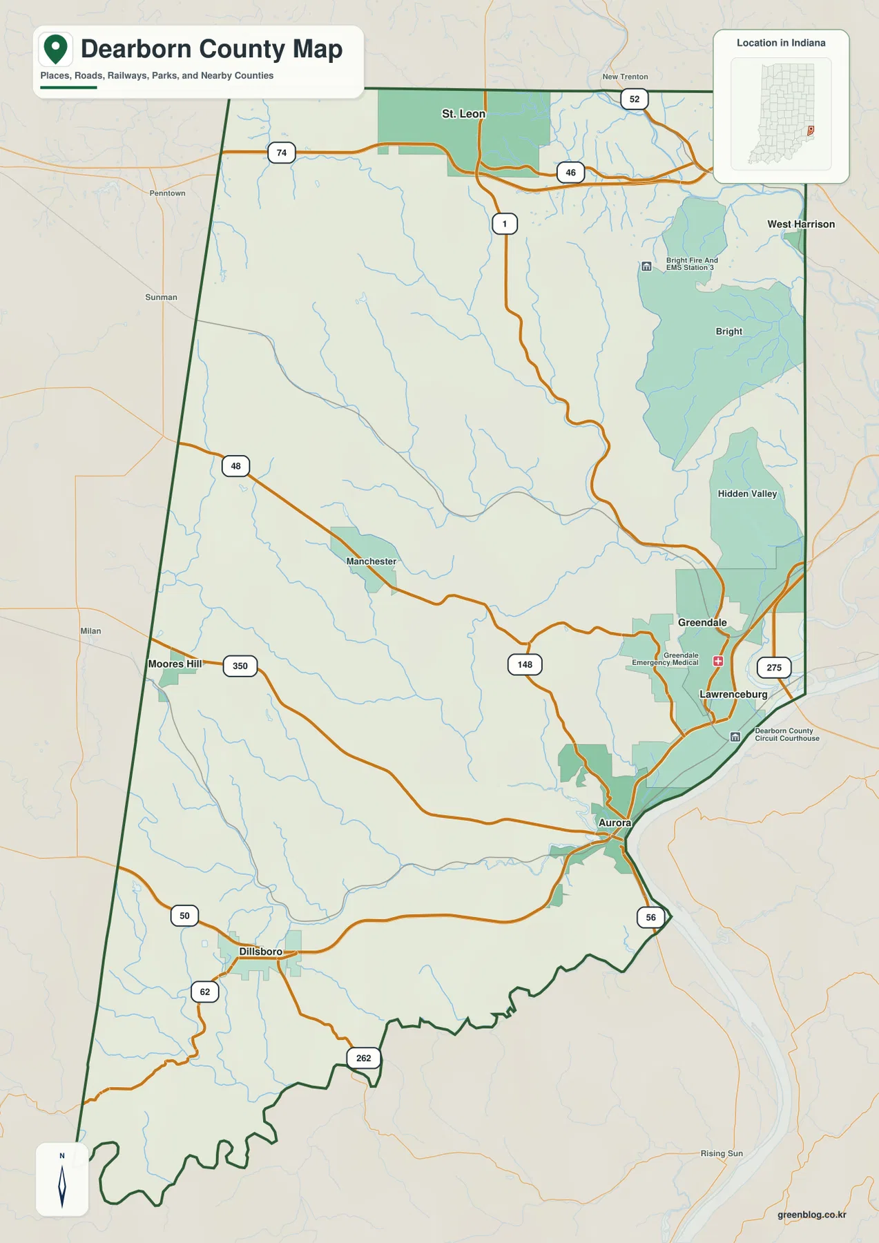
The shape of the county also matters. Much of the western edge is relatively straight, while the southern boundary contains a series of smaller bends. On the southeast, the outline narrows toward the Ohio River and follows a more irregular edge. Franklin County is shown to the north, Ripley County to the west, and Ohio and Switzerland counties appear toward the southwest. Using those neighboring labels together with the river makes it easier to place Dearborn County within the far southeastern corner of Indiana.
Bright and Hidden Valley are useful eastern reference points because they sit above the Lawrenceburg-Greendale area but below the far northeastern edge. Roads connecting these communities descend through a landscape of narrow valleys instead of crossing one broad plain. In the west, Moores Hill and Dillsboro are separated by wider rural spaces and fewer large built-up areas. The general map is not intended to replace navigation software, so it should be used to understand where places and routes lie within the county rather than to estimate travel time or current road conditions.
Six ranked communities show a riverfront and inland split
The city-distribution map removes much of the road detail and focuses on six ranked communities. Lawrenceburg is shown first, followed by Greendale, Aurora, Dillsboro, St. Leon, and Moores Hill. The first three sit close together in the southeastern corner near the Ohio River. The remaining three are much more widely separated: St. Leon is near the north, Moores Hill is in the western interior, and Dillsboro lies farther southwest. This simplified view makes the county’s settlement pattern easier to remember than the more detailed road map.
Lawrenceburg and Greendale almost form a paired reference point on this map because their markers are so close. Aurora extends the riverfront group to the southwest, but there is a much larger gap before reaching Dillsboro in the interior. St. Leon is isolated from the riverfront cities by the broad northern half of the county, and Moores Hill fills part of the western middle. The result is not a single line of towns but a southeastern cluster plus several inland communities distributed across the hills.
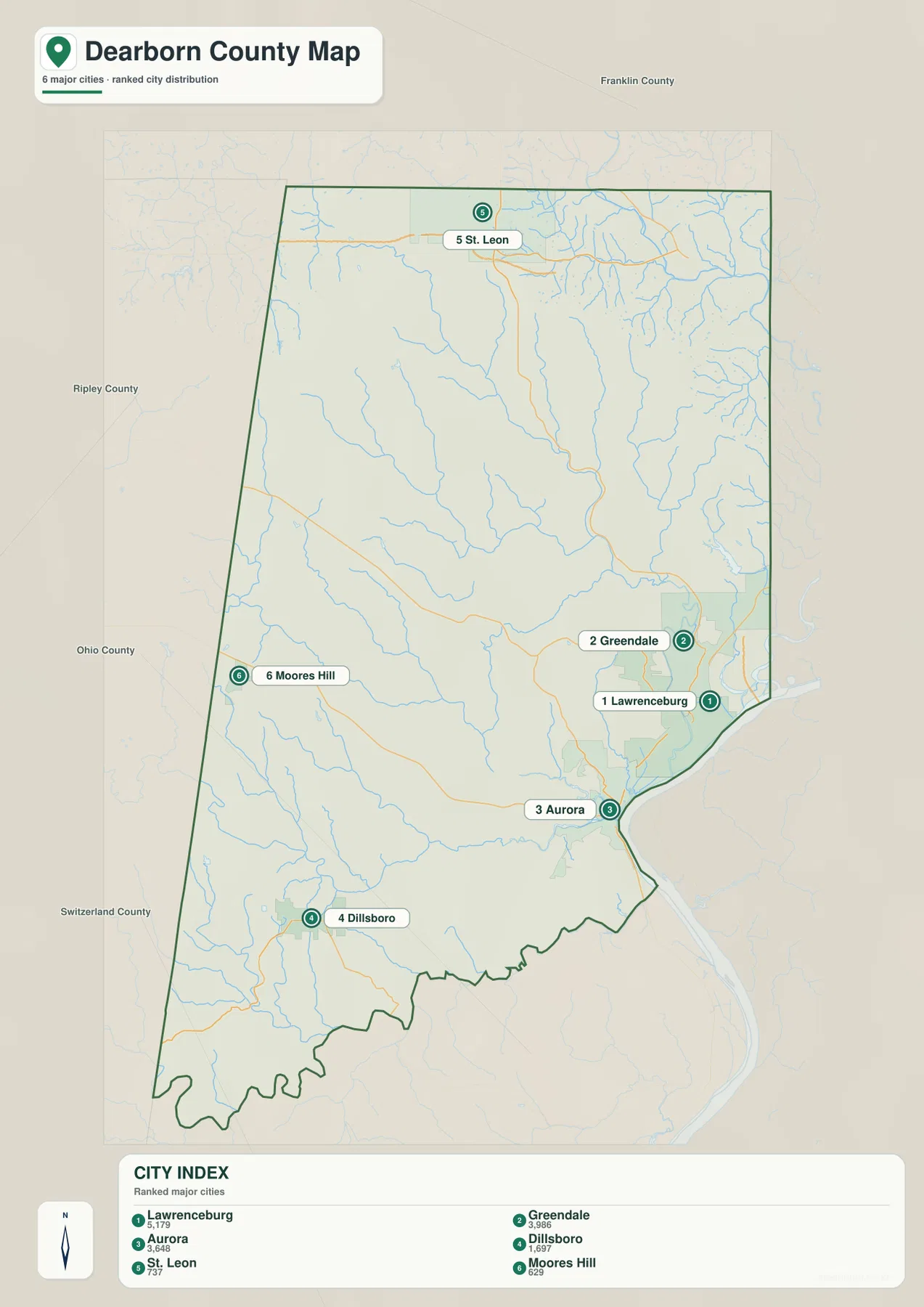
Neighboring county labels help with orientation. Franklin County is north of the mapped area, Ripley County is to the west, and Ohio and Switzerland counties appear along the southwestern side. Those labels are useful for seeing which Dearborn County communities sit closest to an outer edge, but they do not define commuting areas or actual driving distances. For route planning, return to the general map after using the city map to understand the broad direction of each community.
The numbers in the city index provide a size ranking, but this article is not a population-trend analysis. The more useful information here is the spacing between the communities. In a county with deeply cut terrain, two places that look close in a simple overview may be connected by a road that bends around ridges and stream valleys. Looking at the city map and the general road map together prevents the simplified settlement diagram from being mistaken for a road-distance chart.
The Ohio and Whitewater rivers frame a network of deep tributary valleys
The terrain-and-water map is dominated by the Ohio River along the southeastern edge. It occupies a broad low corridor beside the Lawrenceburg and Aurora side of the county. The Whitewater River enters the northeastern corner as another major waterway. Between those two larger rivers, Tanners Creek and its tributaries cut through the interior. The surrounding shaded relief shows that these are not shallow lines across flat ground; the streams occupy distinctly lower valleys between higher ridges.
Tanners Creek provides one of the best central reference lines. Fork Tanners Creek and Salt Fork are also labeled, showing how separate branches join the larger creek system. The northeast contains an especially dense set of small tributaries draining toward the Whitewater River and the eastern lowlands. When these waterways are compared with the elevation map, the branching green valleys become easy to recognize because each stream follows a lower passage through the hills.
In the western and southwestern part of the county, the Hogan Creek system becomes more important. Little Hogan Creek and Hogan Creek run through the west-central interior, while S Hogan Creek is labeled farther south. Smaller named streams include Wilson Creek, Allen Branch, Hayes Branch, and Boyd Branch. Rather than memorizing every tributary, it is more practical to divide the map into a few recognizable systems: the Ohio River edge, the Whitewater River in the northeast, Tanners Creek in the center and east, and the Hogan Creek branches in the west.
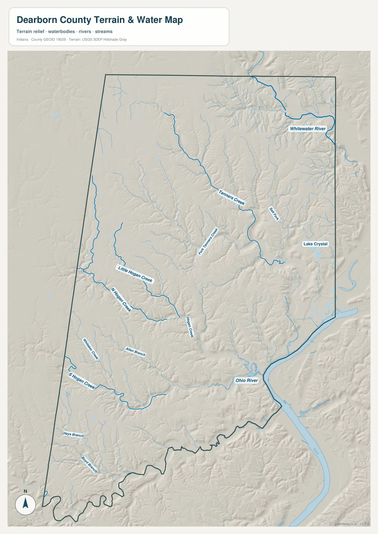
Lake Crystal is labeled in the eastern portion of the map and provides another useful location marker. Its presence should not be interpreted as information about depth, public access, water quality, ownership, or boating rules, because those details are outside the scope of this map. The same caution applies to the rivers and creeks. A low valley on this reference map is not a flood determination for an individual property, and it cannot replace current flood maps, parcel records, or site-specific drainage information.
The shaded terrain is useful because it explains why the drainage network looks so dense. Narrow low corridors branch repeatedly through the county, separated by short, steep ridges. In the northeast and center, the tributary pattern is particularly fine, while the Ohio River creates a much broader low corridor along the southeast. This map is therefore best used to understand the relative position of rivers, creeks, lakes, and valley terrain at county scale, not as a navigation chart, flood certificate, or engineering drainage model.
Elevation ranges from about 138 to 317 meters across steeply dissected hills
The elevation map makes the county’s relief immediately visible. The actual mapped range is about 138 to 317 meters, with a mean near 244 meters. The lowest green areas follow the Ohio River in the southeast and continue inland along major stream valleys. Much of the western and northwestern upland is orange or brown, indicating higher ground. The interior is not a smooth slope between those areas; it is repeatedly broken by narrow green valleys that extend between the ridges.
The northeast is especially intricate. Low corridors connected with the Whitewater River are bordered by closely spaced higher slopes, and small tributary valleys branch westward into the uplands. Around Tanners Creek, a longer green corridor reaches through the center while high ground rises quickly on either side. The western half contains larger areas of high terrain, but Hogan Creek and its branches still cut distinct lower routes through it.
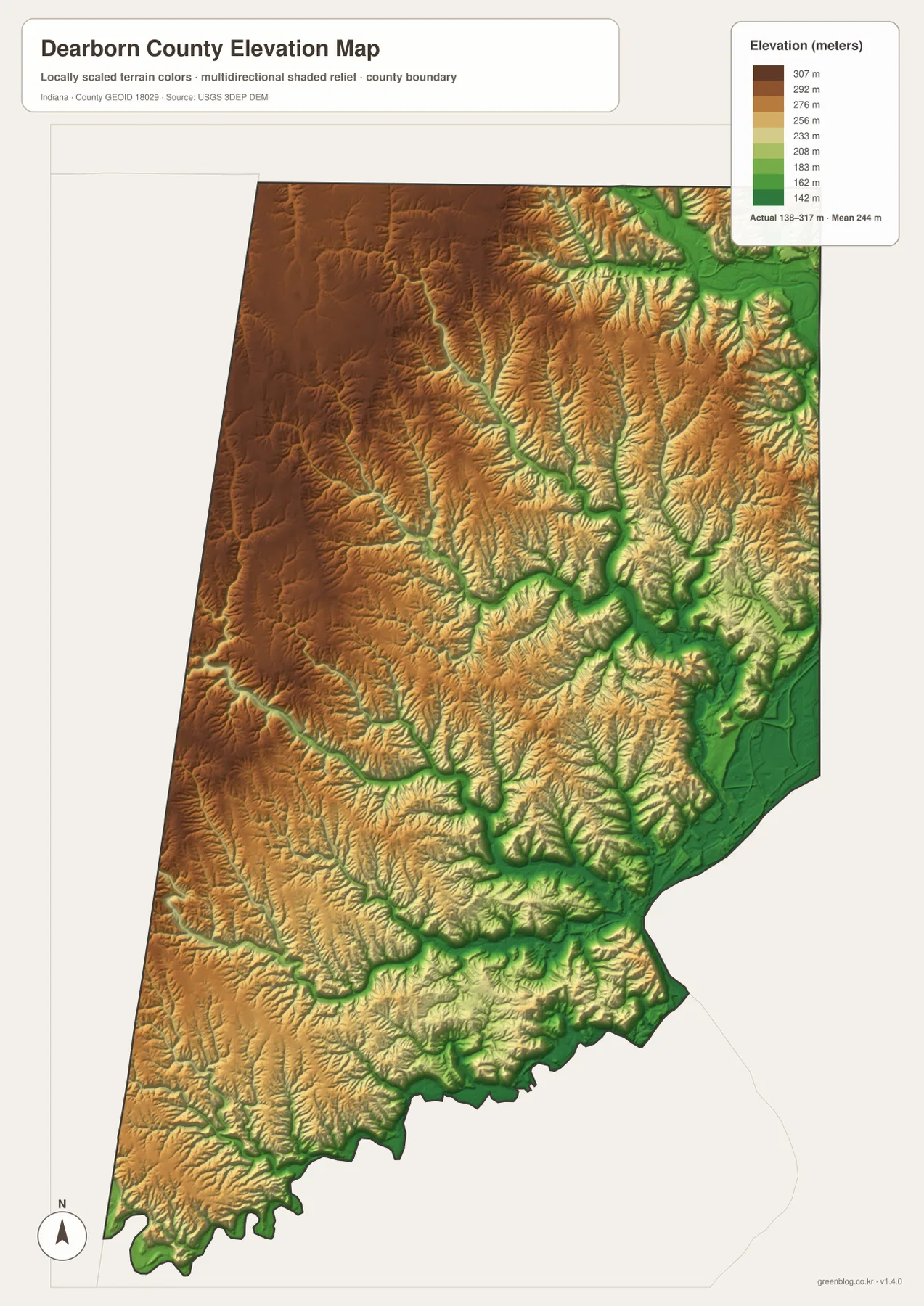
The southwest shows the same ridge-and-valley structure at a different scale. Around Dillsboro and south toward the county boundary, small stream valleys divide the higher surface into many separate ridges. Near Lawrenceburg and Aurora, the Ohio River lowland becomes broad and obvious, but higher terrain rises rapidly only a short distance inland. That sharp change helps explain why roads in parts of the eastern county follow valley floors and curved hillsides rather than a simple rectangular grid.
This elevation image is generalized for county-wide comparison. It does not provide survey-grade heights for a parcel, road, building site, or drainage structure. Small cuts, embankments, graded pads, and other local changes may be too small to appear accurately. Engineering, construction, surveying, and detailed drainage work should use the underlying USGS elevation data or professional site measurements. Here, the map is most useful for comparing the broad low river corridors with the higher, dissected interior.
Combine the maps to move from place names to terrain
For basic orientation, start with the general map and find Lawrenceburg, Aurora, St. Leon, and Dillsboro. Those four locations define the southeastern, northern, and southwestern parts of the county without requiring you to learn every road. Use the city-distribution map next if you want a cleaner comparison of the six ranked communities. Removing much of the road detail makes the riverfront cluster and the separated inland towns immediately obvious.
For landscape questions, begin with the Ohio River and Whitewater River on the terrain-and-water map. Then follow Tanners Creek or Hogan Creek into the interior and look for the same corridor on the elevation map. The connection becomes clear: low green valleys track the streams, while yellow, orange, and brown ridges occupy the higher ground between them. Repeating the same location across two maps is more useful than treating each map as an isolated product.
The WebP images embedded in the article are reduced for faster page loading. If you need to enlarge road labels and creek names, print a map, or keep an offline copy, download the original high-resolution JPG files below. The archive contains the general county map, city-distribution map, terrain-and-water map, and elevation map, each at 2572 × 3638 pixels. These are county-scale reference maps and should not replace legal parcel maps, flood determinations, professional surveys, or engineering plans.
Official sources add context to the Lawrenceburg riverfront
Dearborn County’s official government material places the county government center in Lawrenceburg, which matches the courthouse marker on the general map. Indiana’s county-history material also describes Lawrenceburg as an important early center tied to river and rail connections. Those sources add local context to what the maps show visually: the southeastern riverfront has long been a major point of settlement and access, while the interior spreads across a much more dissected upland landscape.
Different source types are useful for different features. Census TIGER/Line data supports county boundaries, roads, and named places. USGS National Hydrography is the appropriate source for river and stream networks, while the USGS 3D Elevation Program provides the underlying elevation information used to understand the 138–317 meter relief. The links below lead to official or government-maintained pages where those datasets and county information can be checked directly.
Frequently Asked Questions
Which map is easiest for comparing Lawrenceburg, Aurora, and St. Leon?
Use the city-distribution map first because it removes most road detail and makes the spacing between the communities clear. Lawrenceburg and Greendale form a close southeastern pair, Aurora is just southwest along the river side, and St. Leon is much farther north. When you need to see the connecting routes, switch to the general county map.
Where is the strongest elevation contrast in Dearborn County?
The lowest terrain follows the Ohio River and major creek valleys, while higher uplands cover much of the west and northwest. The mapped elevation range is about 138 to 317 meters, with an average near 244 meters. The transition is not smooth because tributaries cut narrow low valleys deep into the higher interior.
What files are included in the Dearborn County download?
The ZIP contains high-resolution JPG copies of the same four maps used in the article: the general county map, city-distribution map, terrain-and-water map, and elevation map. Each file is 2572 × 3638 pixels. They are useful for detailed viewing and printing but are not legal parcel, flood, survey, or engineering products.
Map File Information
Download the Dearborn County maps as high-resolution JPG files for closer viewing, printing, or offline reference.
- File Type: JPG
Related Maps
Sources and references
- Dearborn County official government website — county government and Lawrenceburg administrative context
- Indiana Bicentennial Commission — Dearborn County history, Lawrenceburg, and Ohio River context
- U.S. Census Bureau TIGER/Line Shapefiles — county boundaries, roads, and places
- USGS National Hydrography — rivers and streams
- USGS 3D Elevation Program — elevation and terrain data
Green Map creates custom-edited map images using open geographic data sources such as geoBoundaries, Natural Earth, OpenStreetMap, and government open data.
These maps are edited visual materials, not raw data files, and are provided for education, documents, presentations, and graphic reference.