This Brown County Indiana Map page lets you download high-resolution JPG versions of the included maps in one ZIP, while the WebP copies below are sized for quick online viewing. Brown County sits in south-central Indiana, where Nashville is the main anchor and State Road 46 crosses town before the road network bends through narrow valleys and over ridges. The page separates that geography into a general county view, a simplified city view, a terrain-and-water view, and an elevation view, so roads, settlements, streams, lakes, and relief can be checked without crowding everything onto one image.
The strongest feature is relief. The supplied elevation graphic reports an actual range of about 164 to 322 meters, with a mean near 232 meters. Those numbers do not describe one broad slope from high to low. Instead, ridge after ridge is cut by green valley floors, giving Brown County a tightly folded appearance. North Fork Salt Creek, Middle Fork Salt Creek, North Fork Beanblossom Creek, Gnaw Bone Creek, and smaller tributaries occupy many of those lower corridors, while lakes appear along several edges and within the hill country.
Nashville is also unusually important to the settlement pattern shown here. The ranked city graphic contains only Nashville as a major city and prints 1,386 beside it. The wider county map adds places such as Helmsburg and Bear Wallow, while the northeastern corner is easy to recognize from Cordry and Sweetwater Lakes. That combination makes Brown County a page where roads, creeks, ridges, and lakes explain as much as city names do. The sections below use those visible features rather than treating the county as a generic collection of map layers.
Table of Contents
Nashville is the quickest anchor for the county map
Start with Nashville near the central part of Brown County. State Road 46 passes through town from west to east and gives the clearest first reference for the county. State Road 135 leaves the Nashville area toward the south, while State Road 45 heads toward Helmsburg in the northwest. The secondary roads do not form a clean square grid. Many curve around hills or follow lower ground, which is one of the first hints that the terrain is controlling the shape of the road network.
Helmsburg appears northwest of Nashville along the SR 45 corridor, and Bear Wallow is labeled farther toward the northwestern side. In the opposite corner, Cordry Sweetwater Lakes create a very different landmark near the northeastern edge. When a reader needs to find a place quickly, these three references—Nashville, Helmsburg, and the paired lakes—are more useful than trying to memorize every small road. SR 46 then provides a simple line for moving back across the county.
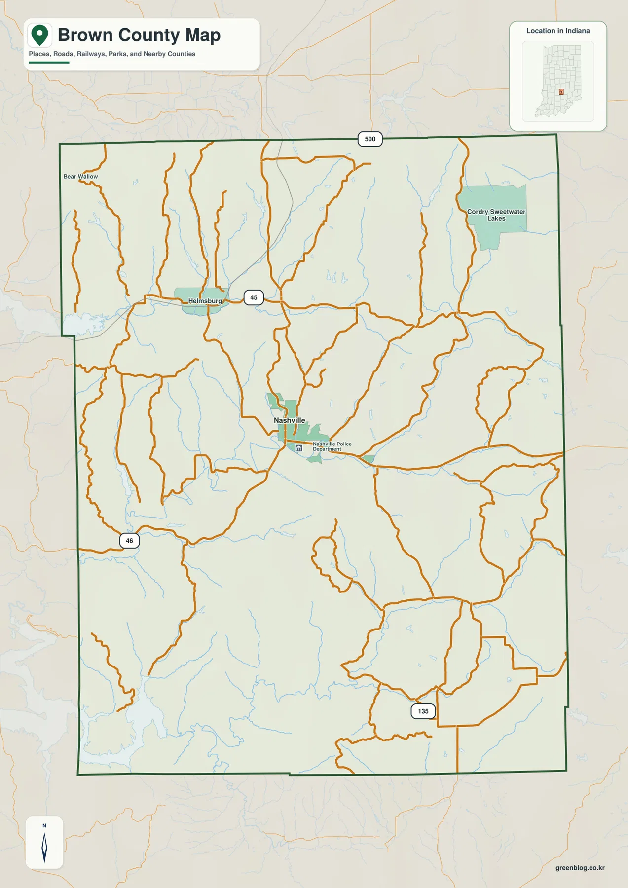
This is a county-scale reference map, not a parcel or ownership map. Its boundary is useful for understanding the extent of Brown County, and the roads are appropriate for broad orientation, but the graphic is not intended to settle property lines or replace turn-by-turn navigation. It works best when the question is where Nashville sits within the county, which major state road crosses a particular part of the map, or how a named place relates to the surrounding terrain.
A city index dominated by one place
The city-distribution map removes most of the road detail and makes the settlement pattern unusually simple. Its ranked index shows Nashville alone in first place, with the number 1,386 printed next to the name. Whether a reader is preparing a classroom graphic, a quick county locator, or a presentation slide, this view makes one point immediately: the selected major-city layer is centered on Nashville rather than on several similarly ranked towns.
Names for neighboring counties are also placed around the outside of the Brown County outline, including Johnson, Bartholomew, Monroe, Jackson, and Morgan counties. They help situate Brown County within the surrounding part of Indiana without adding more internal labels. The map is therefore useful when a clean regional locator is more important than the detailed road network. For routes and smaller named places, the general map remains the better choice.
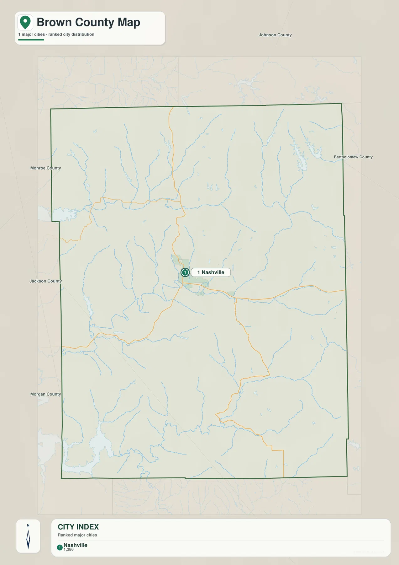
Brown County’s official government website also places the county administration offices in Nashville. That makes the town a useful practical reference as well as a cartographic one. On the general map, returning from this simplified city view to Nashville makes it easy to pick up SR 46, SR 135, and the road toward Helmsburg. The two maps complement each other because one reduces visual detail while the other restores the roads and local context.
Creeks and lakes occupy the low corridors between ridges
The terrain-and-water map is one of the most informative views in this package because the shaded relief and blue drainage lines are shown together. North Fork Beanblossom Creek runs through the northern part of the county, with Lick Creek nearby. Farther south and east, North Fork Salt Creek follows a winding valley and is joined from the east by Gnaw Bone Creek. In the southern part of Brown County, Middle Fork Salt Creek and Hamilton Creek trace another set of low corridors through the hills.
Several named lakes break up that drainage network. Cordry Lake and Sweetwater Lake are close together in the northeast. Lake La Salle appears farther west across the northern half, while Yellowwood Lake, Somerset Lake, and Ogle Lake are labeled in the western and central hill country. A broad portion of Monroe Lake reaches the southwestern edge of the map. Because the water features range from narrow streams to substantial lake surfaces, the map gives a much better sense of Brown County’s varied water geography than the general road map alone.
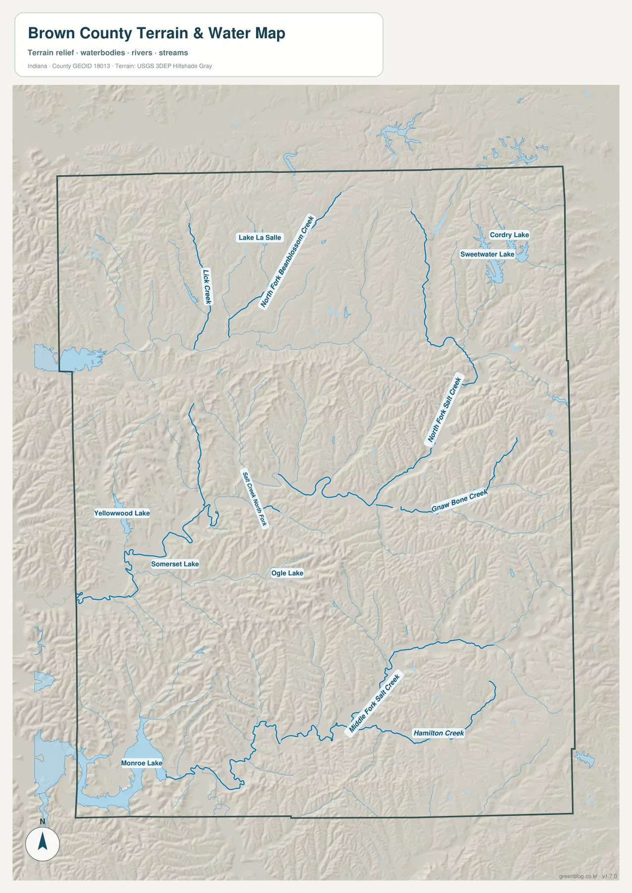
The hillshade matters because it shows that the streams are not simply blue lines drawn across a flat surface. Many follow narrow valleys between ridges, and the branching pattern becomes easier to understand when the relief is visible underneath. This map should still be treated as a geographic reference. It does not show flood-insurance zones, legal water boundaries, water depth, current flow conditions, or navigability.
A 158-meter elevation spread packed into repeated ridges
The elevation map states an actual Brown County range of about 164 to 322 meters, a difference of roughly 158 meters from the low end to the high end. The mean is shown near 232 meters. What makes the map striking is not just that total range but how often the colors change across short distances. Narrow brown and tan ridge crests sit beside green valley floors, producing a dense texture across nearly the entire county.
Lower green terrain is especially visible along the main creek valleys and around the southwestern Monroe Lake area. Higher tones return quickly on the adjacent ridges, and similar alternation continues across the north, east, and south. That pattern helps explain why the road map contains so many curves: direct straight lines are less common where repeated ridges and valleys break up the landscape. It also explains why the water map shows such a branching system of smaller creeks.
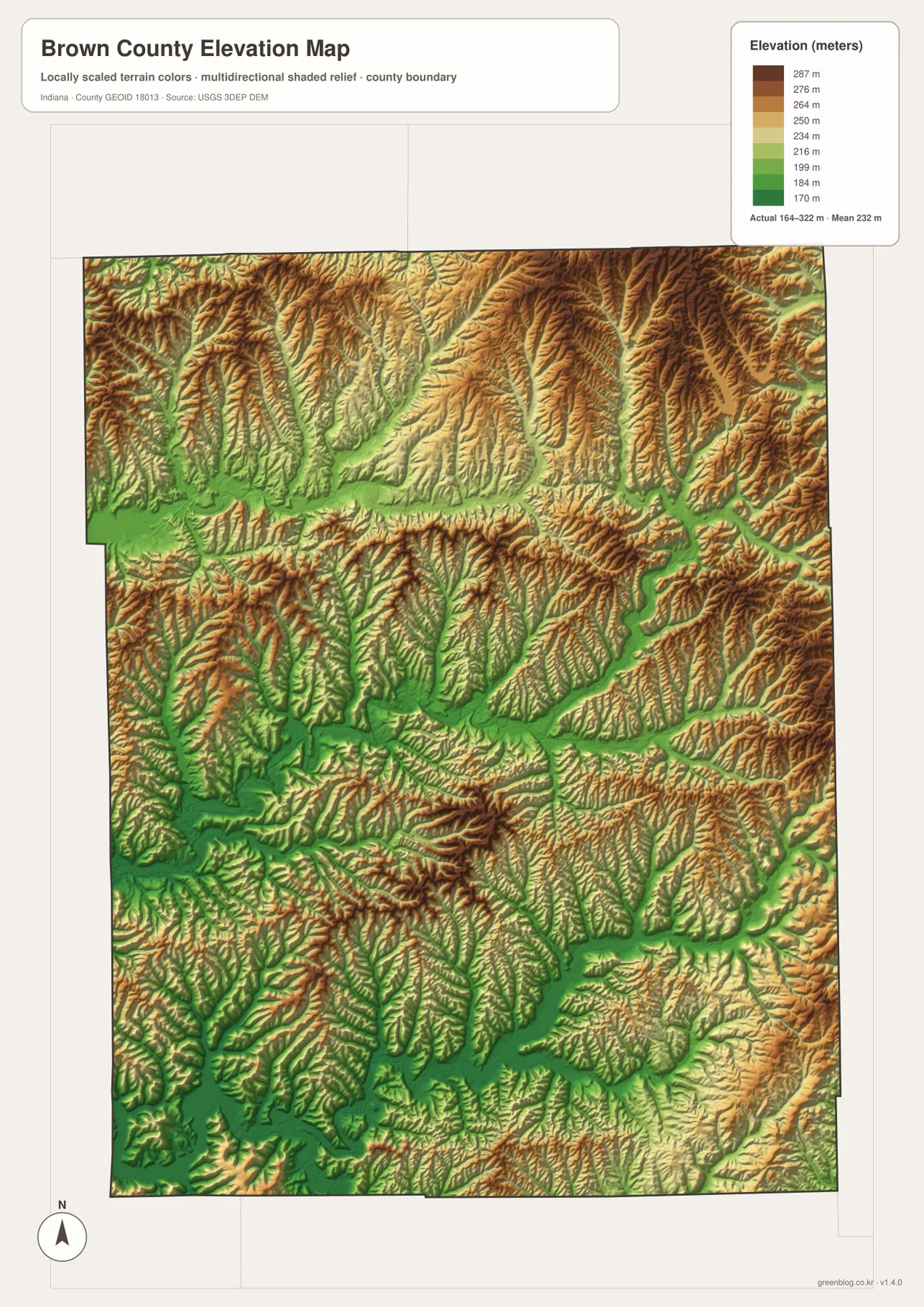
The color scale is locally useful rather than a promise that the same color means the same height on every county map. The surface is also generalized for countywide reading. It can show that one ridge is higher than a nearby valley, but it should not be treated as a survey measurement for a specific parcel, building site, road grade, or drainage design. Work that depends on exact elevation requires more precise, purpose-specific data.
Brown County State Park provides real-world context for the rugged relief
Indiana’s Department of Natural Resources describes Brown County State Park as nearly 16,000 acres of rugged hills, ridges, and ravines. The agency also explains that the most recent glaciers stopped short of this hill country, while meltwater helped shape narrow ridges, steep slopes, and deep gullies. That description closely matches the landforms visible on the supplied elevation map, where high narrow crests are repeatedly separated by lower valleys.
The park information also gives road references that connect naturally to the county map. The west gate is on SR 46 west of Nashville, and the horse camp is reached from SR 135 south of the SR 46 intersection. Those details make Nashville, SR 46, and SR 135 more than abstract map labels. They are practical orientation points in the part of Brown County known for its steep, wooded landscape. The county maps here do not replace the park’s own trail and campground maps, so visitors should use the current Indiana DNR property map for park-specific navigation.
Choosing the map by the question you need to answer
For a first look at Brown County, the general map is the best starting point because roads, Nashville, Helmsburg, lakes, and the county outline remain in one frame. The city view is better when the goal is to show Nashville cleanly without the full road network. A reader interested in named creeks or lakes should move to the terrain-and-water map, where North Fork Salt Creek, Beanblossom Creek tributaries, and the various lakes are labeled directly.
The elevation view answers a different question: where are the ridges and lower valleys? Comparing it with the water map is especially useful in Brown County because many streams occupy the green low corridors between higher ridge lines. For a presentation, those two maps can explain the landform-water relationship far more clearly than a long list of stream names. For travel orientation, however, the road map remains more practical because the elevation view intentionally removes most road detail.
The WebP images in the article are reduced for fast viewing. The ZIP below contains separate high-resolution JPG versions of the general county map, city-distribution map, terrain-and-water map, and elevation map. Each image is 2572 × 3638 pixels, giving substantially more room for print layouts or closer inspection of labels. Since the maps remain separate files, there is no need to use every layer when only roads, water, or terrain is relevant.
Countywide reference is not a substitute for parcel, flood, or survey data
The detailed-looking terrain can make these maps seem more precise than their intended purpose. They are countywide reference graphics. The general map provides orientation, the city layer simplifies settlement, the water map identifies streams and lakes, and the elevation map compares broad high and low areas. None of them is intended to define legal ownership, a regulated stream corridor, a flood-insurance boundary, or an engineering elevation at a particular point.
For those specialized questions, use the appropriate official record or data service. The sources below include Brown County’s government website, Indiana DNR information for Brown County State Park, Census geographic resources, USGS hydrography, and the USGS 3D Elevation Program. Together they provide useful follow-up paths when a county-scale JPG is not enough for the task.
Frequently Asked Questions
Which roads are the easiest starting points for finding Nashville and the surrounding hills?
State Road 46 is the simplest first reference because it crosses Brown County through Nashville. From there, SR 135 continues south and SR 45 leads toward Helmsburg in the northwest. The smaller roads curve frequently through the hill country, so beginning with those three numbered routes makes the general map much easier to follow.
Can one map show North Fork Salt Creek and the main Brown County lakes together?
Yes. The terrain-and-water map labels North Fork Salt Creek, Middle Fork Salt Creek, North Fork Beanblossom Creek, Gnaw Bone Creek, and several other waterways. It also shows Cordry, Sweetwater, Yellowwood, Somerset, Ogle, and Monroe lakes. The map is for broad location and terrain context, not for flood zones, water depth, navigation, or legal water boundaries.
Does the 164–322 meter elevation range give an exact height for a property?
No. The range describes the actual countywide minimum and maximum reported on the supplied elevation graphic, and the map is useful for comparing ridges with lower valleys. It does not guarantee a precise elevation at a house, parcel, roadway, or construction site. Survey and engineering decisions require more accurate, purpose-specific elevation information.
Map File Information
Download the Brown County maps as high-resolution JPG files for printing, presentations, or closer inspection of road, water, and terrain detail.
- Included Files: general county map, city-distribution map, terrain-and-water map, and elevation map
- Printable Size: 2572 × 3638 px for each map
- File Type: four JPG images in one ZIP archive
Related Maps
Sources and References
- Brown County, Indiana official website — county administration and local information
- Indiana DNR Brown County State Park — park access, rugged hills, ridges, ravines, and local landscape context
- U.S. Census Bureau TIGER/Line Shapefiles — county boundaries, roads, and place geography
- USGS National Hydrography — streams and water features
- USGS 3D Elevation Program — elevation and terrain data
Green Map creates custom-edited map images using open geographic data sources such as geoBoundaries, Natural Earth, OpenStreetMap, and government open data.
These maps are edited visual materials, not raw data files, and are provided for education, documents, presentations, and graphic reference.