High-resolution JPG map files for Allen County, Indiana are available on this page as a downloadable ZIP. Fort Wayne is the main reference point for understanding the county: its urban area fills the central part of the map, New Haven continues the built-up pattern to the east, and smaller communities spread into the northern and eastern parts of the county. The supplied maps also show the major road network, the St. Joseph and St. Marys rivers meeting near Fort Wayne before the Maumee River continues east, and an actual elevation range of about 144 to 293 meters.
The county boundary is not a simple rectangle. A noticeable indentation on the western side and the long eastern edge make the outline easy to recognize once you have seen it. Fort Wayne dominates the middle of the map, but a ring of smaller communities spreads into the north, east, and south: Huntertown, Leo-Cedarville, Grabill, Harlan, Woodburn, Monroeville, Hoagland, and Hessen Cassel are all labeled. This distribution matters because the county’s road pattern and river valleys do not radiate evenly in every direction.
The natural setting becomes clearer when the water and elevation maps are compared. The St. Joseph River descends from the north, the St. Marys River approaches from the south, and the Maumee River runs eastward from the Fort Wayne area. Cedar Creek, the Eel River, several reservoirs, and smaller lakes add separate water features in the northern and western parts of the county. On the elevation map, the western and northwestern ground is generally higher, while lower green corridors follow the major river system toward Fort Wayne and the eastern county line.
Table of Contents
Fort Wayne Anchors the Road Network, with New Haven Extending East
The general county map places Fort Wayne at the center of a dense road network. US 27 approaches from the north, US 30 crosses the northern and eastern side of the urban area, and I-69 runs along the western side. I-469 appears around the south and east side of the metropolitan area, creating a large outer route that is visually distinct from the local road grid. Instead of trying to memorize every road number at once, it is easier to start with Fort Wayne and follow the major routes outward toward the smaller communities.
New Haven is the closest named city to Fort Wayne on the east side and is positioned near the same broad east-west corridor. Farther east, Woodburn stands near the county’s eastern edge, with State Road 101 shown running north-south nearby. Monroeville lies well to the southeast, where State Roads 101 and 114 help locate that corner of the county. Hoagland and Hessen Cassel appear south of Fort Wayne, giving the lower half of the map several smaller reference points rather than one continuous urban block.
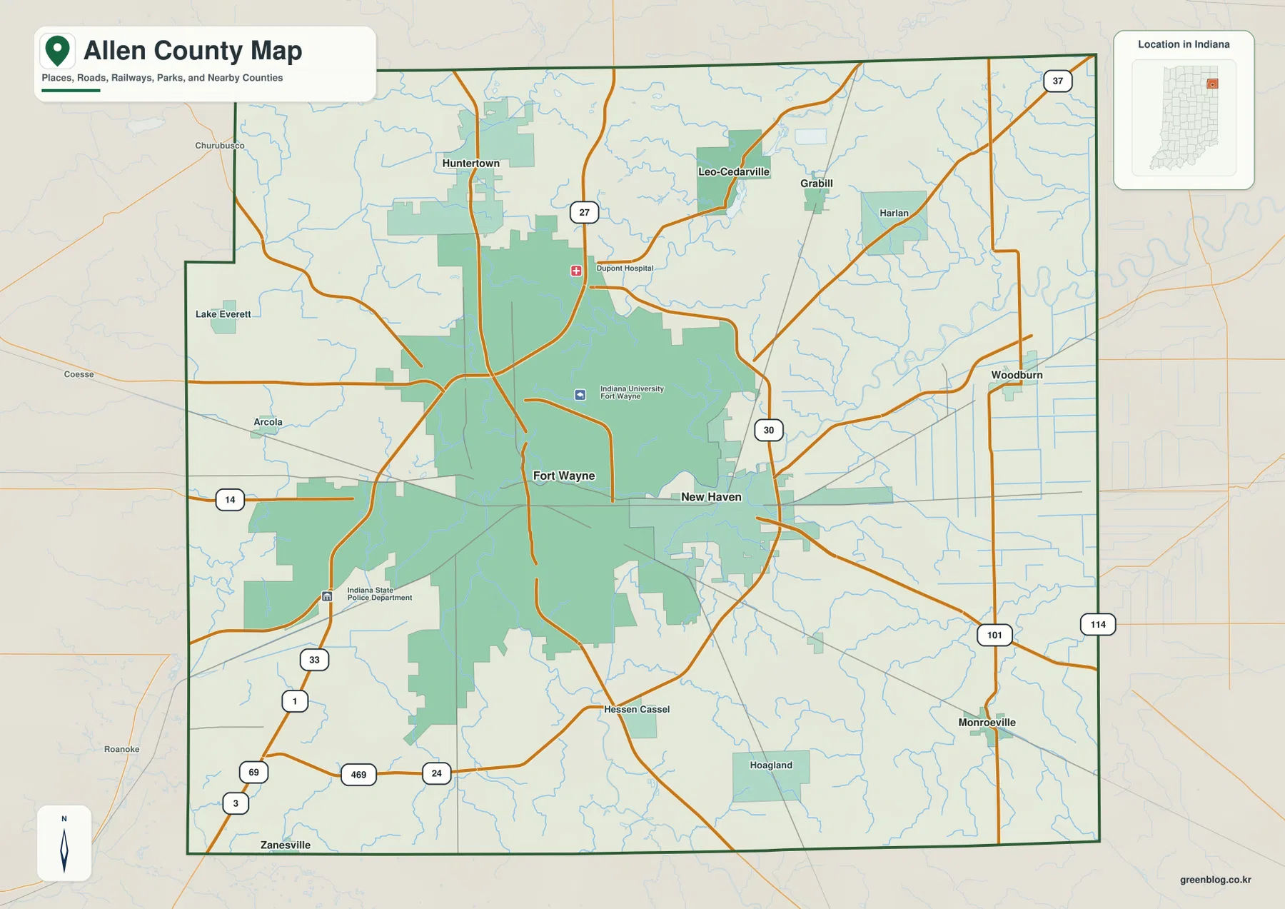
North of Fort Wayne, Huntertown is the clearest separate community on the map. Leo-Cedarville and Grabill sit farther to the northeast, while Harlan is closer to the northeastern boundary. State Road 37 is visible in that part of the county, and numerous small streams break up the road grid. On the west side, Arcola and Lake Everett provide smaller landmarks, but the developed area is much less extensive than around Fort Wayne. The contrast between the large urban center and the outlying communities is one of the strongest features of the map.
This map is most useful for county-scale orientation: roads, communities, the county outline, and the relationship between built-up areas and smaller streams. It is not intended to replace current navigation, traffic information, parcel maps, or legal boundary surveys. For travel planning, use it to understand direction and county context, then check current road information for an exact route. Its strength is showing how the main places fit together across the whole county.
The City Index Spreads North and East from Fort Wayne
The city map strips away much of the road detail and highlights six major communities by rank and location. Fort Wayne is the dominant center, New Haven is immediately east of it, Huntertown is north, Leo-Cedarville is northeast, Woodburn is near the eastern side, and Monroeville is farther south in the southeast. With fewer labels competing for attention, this version makes the broad settlement pattern easier to understand than the full road map.
Huntertown and Leo-Cedarville are especially useful for understanding the northern half of the county. Huntertown lies closer to the north-central side, while Leo-Cedarville is displaced eastward. Woodburn continues that eastward pattern but sits farther south, and Monroeville forms a separate southeastern reference point. The surrounding county names—DeKalb, Noble, Wells, Adams, Huntington, and Whitley—also appear around the map, so the position of Allen County within northeastern Indiana can be seen without adding extra detail to the interior.
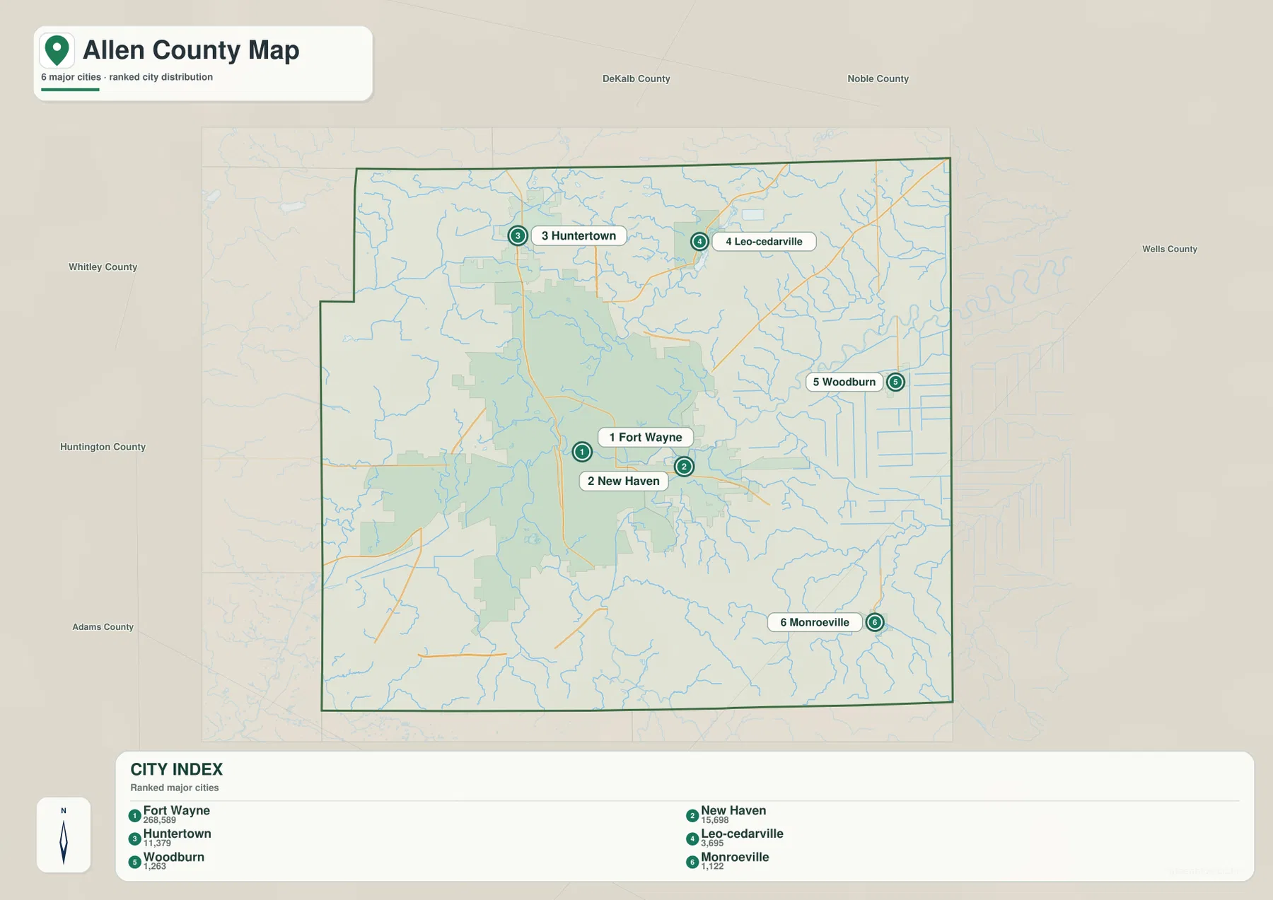
The city index includes numbers beside the community names, but this article does not treat those labels as a statement of current official population. The useful information here is the relative rank and map position. Fort Wayne is clearly the main urban center, while the other communities occupy separate parts of the county. Readers who need current population counts should use a current official statistical source rather than relying on the labels embedded in a map image.
Using the city map and the general map together works well. The city version quickly answers where each major community lies, while the general version answers which highways and local routes connect the same areas. For example, the eastward sequence from Fort Wayne to New Haven and toward Woodburn is immediately clear on the city map; returning to the general map then shows the larger road corridors that cross that part of the county.
The St. Joseph and St. Marys Rivers Meet Before the Maumee Runs East
The terrain-and-water map makes the county’s river system much easier to follow. The St. Joseph River comes down from the north through the central-northern part of Allen County. The St. Marys River approaches from the south. Around the Fort Wayne area, those two large waterways converge, and the main river continuing east is labeled the Maumee River. The relationship is a defining feature of the supplied water map because it links the northern, southern, and eastern parts of the county through one connected river system.
The northern half contains several other named water features. Cedar Creek runs near the St. Joseph River system, and Cedarville Reservoir and Hurshtown Reservoir are shown nearby. Fulk Lake, White Lake, and Viberg Lake appear across the north, while Lake Everett is farther west and Schoaff Lake is closer to the middle-west. Near the northwestern edge, the Eel River is also labeled, showing that not every stream in the county belongs to the same visible corridor as the three rivers around Fort Wayne.
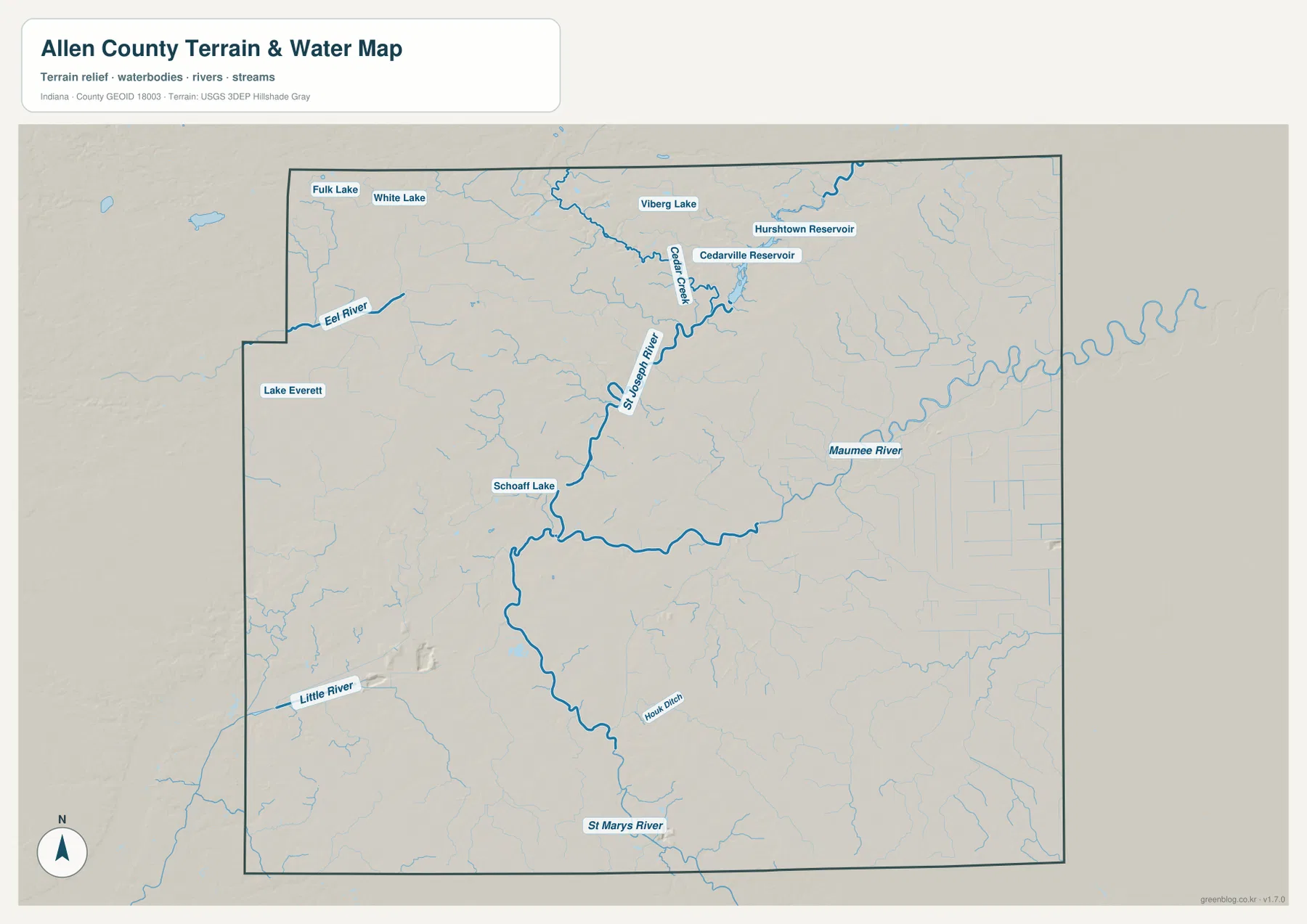
Smaller streams and ditches form a dense blue network between the named rivers. Houk Ditch is labeled in the southern half, and the Little River appears beyond the southwestern side of the county map. Those smaller lines are useful for understanding that the large rivers collect water from many separate local channels. They also help explain the branching low corridors visible on the elevation map.
This is a county-scale reference map for the location of rivers, creeks, reservoirs, lakes, and terrain. It is not a flood-hazard map, navigation chart, parcel map, or legal-water-boundary document. It does not show current water depth, discharge, or flood probability. Anyone making a flood, drainage, navigation, or property decision should use the relevant current official source. On this page, the map is best used for geographic orientation and for comparing the waterways with the elevation surface.
144–293 m Relief: Higher Western Ground and Lower River Corridors to the East
The elevation map gives an actual county-wide range of about 144 to 293 meters, with a mean near 244 meters. The broad color pattern is easy to see: much of the west and northwest is shown in tan and brown tones, while the eastern half contains extensive green lower terrain. The county is not divided by one clean ridge, however. Long river valleys cut through the higher ground, and smaller tributaries create branching low strips within areas that otherwise sit at higher elevations.
The St. Joseph River valley is one of the clearest low corridors. It descends from the north toward the Fort Wayne area, where the low ground widens around the river junction. From there, the Maumee River corridor continues east across a broad green area. The St. Marys River also occupies a lower path approaching from the south. When the water and elevation maps are viewed side by side, the three-river system aligns closely with the lowest visible parts of the county.
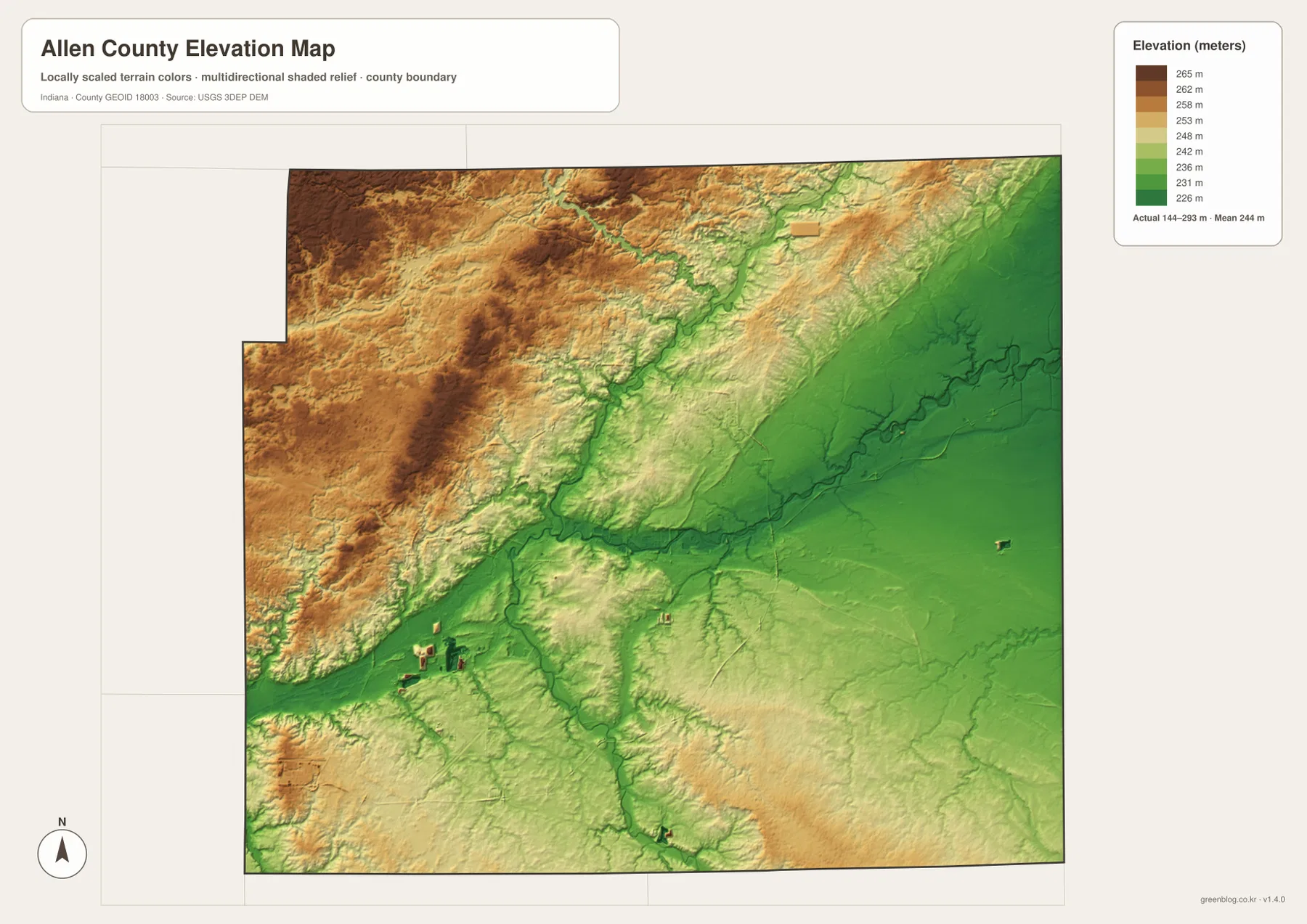
Higher terrain is most visually continuous in the western and northwestern portions of the county. Even there, narrow green channels cut into the tan surface where small streams occupy lower ground. Parts of the northeast also rise above the main river corridor, while the southeast contains a mix of low plain and modestly higher local ridges. This varied surface helps explain why the road map can appear relatively orderly while the natural drainage network is much more irregular.
The elevation surface is generalized for county-wide comparison and should not be treated as a survey-grade measurement for a specific property, building site, road project, or drainage design. Higher-resolution official elevation data or field surveying is necessary for engineering or legal work. Here, the map is intended to show the overall 144–293 meter range and the contrast between the higher western ground and the lower river corridors that cross and leave the county.
Matching the Map to Roads, Communities, Rivers, or Relief
Choose the general county map when you need roads, communities, county limits, and smaller geographic labels together. It is the best starting point for understanding how Fort Wayne, New Haven, Huntertown, Woodburn, Monroeville, and the surrounding areas fit within the county. Choose the city map when the main question is simply where the six highlighted communities lie relative to one another. Its reduced detail makes north, east, and southeast relationships easier to compare at a glance.
The water map is the clearest choice for following the St. Joseph, St. Marys, and Maumee rivers, Cedar Creek, the Eel River, and the county’s reservoirs and lakes. The elevation map answers a different question by showing where the terrain rises and falls. Using those two maps together is particularly useful around Fort Wayne, because the river junction occupies a broad lower area that is less obvious on the road map.
The WebP images displayed on this page are sized for convenient online viewing. The downloadable archive contains the corresponding original JPG files at 3638 × 2572 pixels each. The ZIP includes the general county map, ranked city map, terrain-and-water map, and elevation map. Those larger files are better for zooming into labels or printing, but they remain county-scale reference maps rather than parcel, flood, survey, or engineering documents.
Frequently Asked Questions
Which map best shows how the St. Joseph, St. Marys, and Maumee rivers relate to Fort Wayne?
The terrain-and-water map is the clearest choice. It shows the St. Joseph River approaching from the north and the St. Marys River from the south, with the Maumee River continuing east from the Fort Wayne area. The map is for geographic reference only; it does not determine flood risk, water depth, or legal water boundaries.
Which map is easiest for comparing Fort Wayne with New Haven, Huntertown, Woodburn, and Monroeville?
The ranked city map is the simplest for relative position because it removes much of the road detail. It places New Haven immediately east of Fort Wayne, Huntertown to the north, Leo-Cedarville to the northeast, Woodburn farther east, and Monroeville in the southeast. Use the general county map alongside it when you also need highway and boundary context.
Are the downloaded files larger than the WebP maps displayed on the page?
Yes. The page uses smaller WebP versions for faster online viewing, while the ZIP contains the corresponding JPG originals at 3638 × 2572 pixels each. The larger files are more convenient for close inspection and printing. They still remain county-scale reference maps and should not be substituted for survey-grade, parcel, flood, or engineering data.
Map File Information
Download the high-resolution JPG originals for the Allen County general map, ranked city map, terrain-and-water map, and elevation map shown on this page.
- Included Files: 4 high-resolution JPG maps
- Printable Size: 3638 × 2572 px each
Related Maps
Sources and References
- Allen County, Indiana Official Website – county government and local information
- Allen County Visitors – local visitor and Fort Wayne/Allen County information
- U.S. Census Bureau TIGER/Line Shapefiles – county boundary, road, and place reference data
- USGS National Hydrography – river, stream, and waterbody reference data
- USGS 3D Elevation Program – elevation reference data
Green Map creates custom-edited map images using open geographic data sources such as geoBoundaries, Natural Earth, OpenStreetMap, and government open data.
These maps are edited visual materials, not raw data files, and are provided for education, documents, presentations, and graphic reference.