Whiteside County stretches across northwestern Illinois from the Mississippi River edge near Fulton to the Sterling–Rock Falls area on the east. Morrison sits near the middle of the county, while Prophetstown and Erie mark the southwest and a broad network of creeks cuts through the higher northern ground. The maps on this page show the county boundary and roads, the placement of six major communities, the Rock River and its tributaries, and an elevation range of about 164 to 267 meters. High-resolution JPG versions of the same maps are available together in a downloadable ZIP file below.
The county does not have a single compact urban center in the middle. Sterling and Rock Falls form the most obvious eastern cluster along the Rock River, Morrison provides a central reference point, and Fulton lies far to the northwest beside the large river boundary. U.S. Route 30 crosses the county through Morrison toward Sterling, while I-88 passes south of the Sterling–Rock Falls area. Illinois routes 78, 84, 40, and 2 help connect the interior and edge communities shown on the main map.
Water and relief explain much of the contrast between the northern and southern halves of the county. The Rock River bends through the central-southern corridor, where the elevation surface is generally lower and smoother. North of that corridor, ridges rise sharply and narrow creek valleys cut through them. The western edge along the Mississippi is also low, so the county map becomes easier to understand when the road pattern, river corridors, and elevation map are viewed together rather than as separate pieces.
Table of Contents
A county stretched between Sterling, Morrison, and the Mississippi edge
The general county map is the best place to establish direction. Sterling appears near the eastern boundary with Rock Falls immediately to the south across the Rock River. U.S. Route 30 approaches this area from Morrison, and Illinois Route 40 runs north from Sterling. Illinois Route 2 follows the far eastern side, while I-88 crosses just south of Rock Falls. Together these roads make the eastern part of Whiteside County look much busier than the broad rural areas farther west.
Morrison occupies a very different position near the county center, close to the intersection of U.S. 30 and Illinois Route 78. Lyndon lies to the south, followed by Prophetstown near a sweeping bend of the Rock River. Farther west, Fulton sits beside the Mississippi-side boundary with Illinois routes 84 and 136 nearby, while Albany occupies another point along the western edge. Erie anchors the southwest, and Tampico sits in the southeast, showing how widely the county’s named communities are distributed.
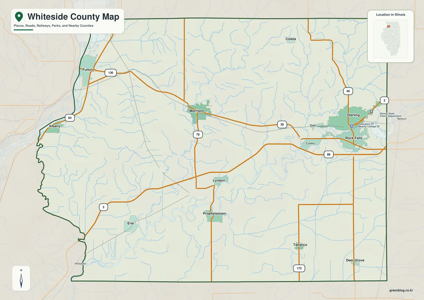
Smaller labels add useful detail between those larger anchors. Coleta appears in the north, Galt west of Sterling, Como west of Rock Falls, and Deer Grove near the southeastern side. The map also shows rail lines and many minor streams, so it works well when the goal is to see how transportation, settlement, and natural features occupy the same space. The western boundary has a noticeably irregular river shape, while long sections of the southern and eastern county lines are much straighter.
This is an orientation map rather than a live navigation product. It can show that Sterling and Fulton are on opposite sides of the county and that Morrison lies between them, but it does not provide current road closures, travel times, or turn-by-turn directions. For a trip, use the map to understand the county first and then consult current navigation or transportation information for the actual route.
Why Sterling and Rock Falls form the eastern cluster
The city-distribution map removes much of the road detail and highlights six major communities. Sterling and Rock Falls sit close together on the eastern side, with Morrison near the center. Fulton is isolated toward the northwest, while Prophetstown and Erie occupy the southwest. That layout makes the county’s settlement pattern easy to grasp: the largest cluster is near the Rock River in the east, but important towns remain spread across the full width of Whiteside County.
The map’s city index ranks Sterling first, Rock Falls second, Morrison third, Fulton fourth, Prophetstown fifth, and Erie sixth. Those figures are best treated as the reference values used by this map package rather than as a substitute for a current population table. Their most useful purpose here is visual: they identify which places the map emphasizes and make it easier to compare each city’s position inside the county.
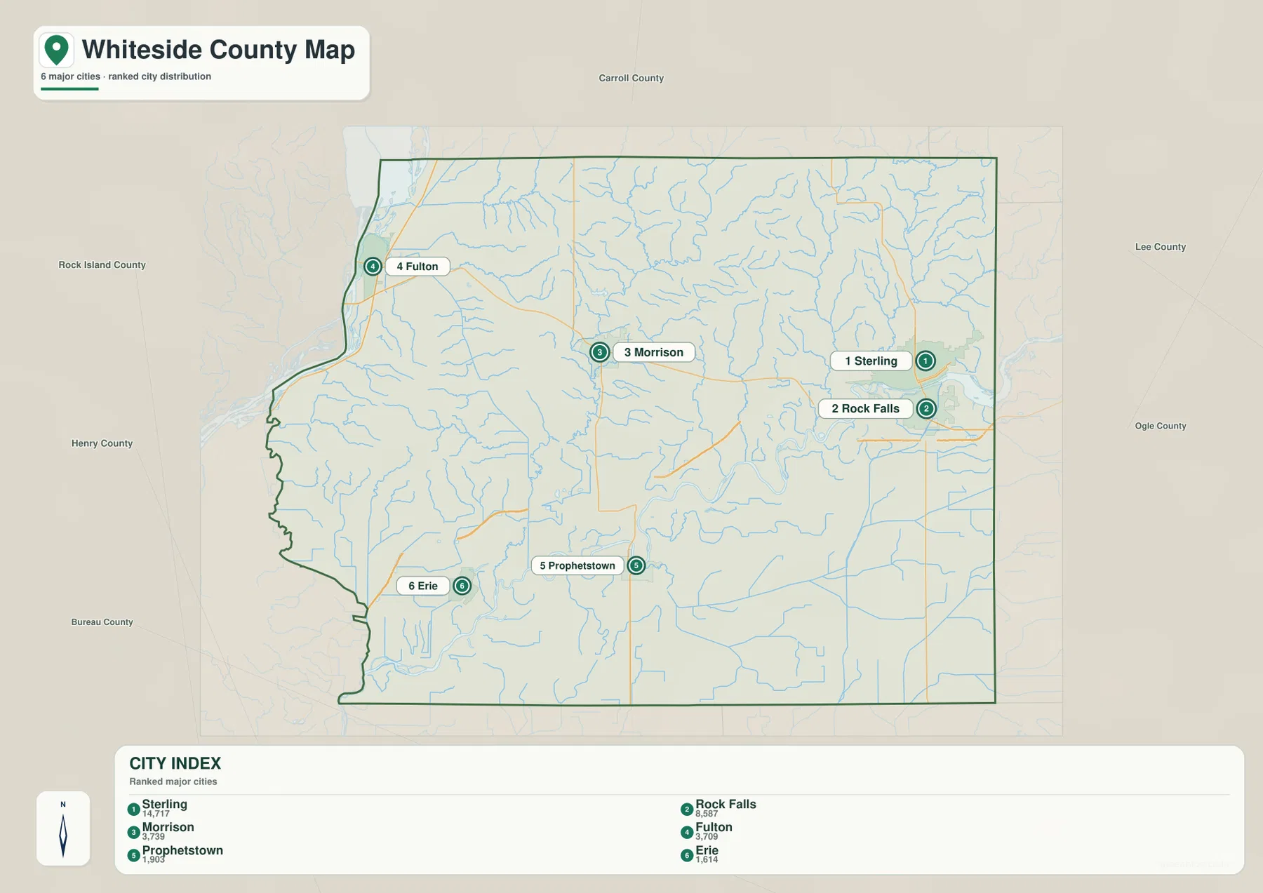
Neighboring counties give the distribution additional context. Carroll County is shown to the north, Lee and Ogle counties to the east, Bureau County to the south, and Rock Island and Henry counties along the western and southwestern sides. With those labels in view, Fulton’s position near the western edge and Sterling’s position near the eastern edge are especially clear. Morrison is the inland point that helps connect the two sides when reading the county as a whole.
No connector-distance numbers are drawn on this city map, so it should not be used to estimate straight-line mileage or driving distance. It is more useful for a classroom map, a regional overview, or a quick explanation of where the principal towns lie. When road detail becomes important, switch back to the general map and use U.S. 30, I-88, and the state routes as the reference lines.
Rock River bends, Lake Carlton, and creeks descending from the north
The water and terrain map changes the emphasis completely. The Rock River is the dominant feature, entering from the east and making broad bends across the central-southern part of the county. Its low corridor is much wider than the narrow creek valleys farther north. In the southeastern corner, the Green River appears as a separate named waterway, while the Hennepin Canal Feeder is marked as a long north-south feature nearby.
North of the Rock River, the drainage network becomes dense. Rock Creek crosses the north-central area, Spring Creek and Elkhorn Creek run through the northeast, and Deer Creek drops toward the river from the interior. French Creek branches through the central-northern hills, with Otter Creek near the northwest and Lynn Creek farther west. These named streams make it easy to see how the higher ground is divided into ridges by many small valleys before water reaches the larger river corridor.
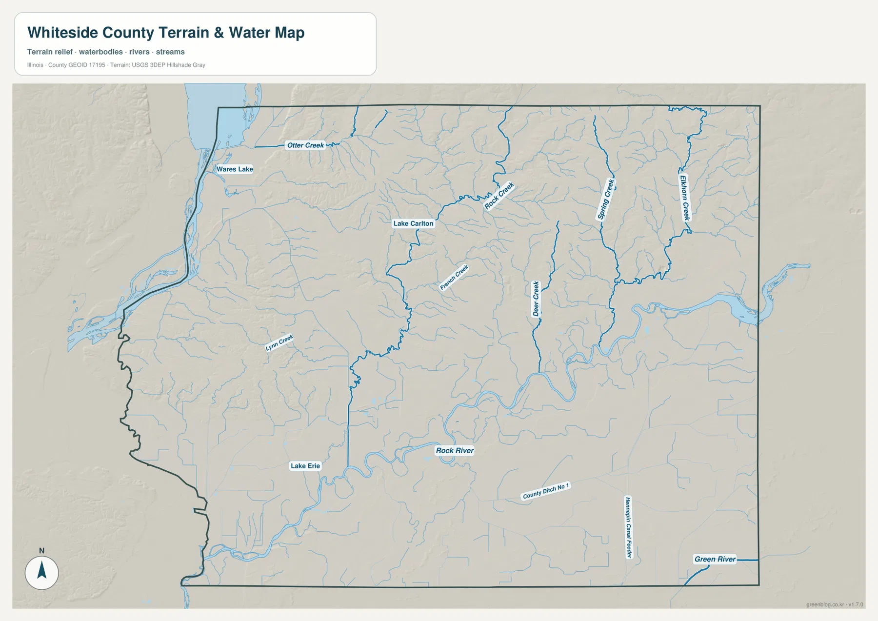
Lake Carlton appears north of Morrison. The Illinois Department of Natural Resources identifies it as a focal point of Morrison-Rockwood State Park, which is located north of Morrison, so the map label is tied to a well-defined local recreation area rather than an isolated water name. Wares Lake is shown near the northwest, and Lake Erie appears in the southwest. Those smaller water bodies are useful landmarks when comparing the river map with the road and city maps.
This map is a geographic reference, not a flood-risk, parcel, water-depth, or navigation chart. A blue line shows where a stream or water feature is represented, but it does not tell the reader whether a site is flood-prone, how deep the water is, or whether boating is safe. For those questions, use the appropriate current agency data. Here the purpose is to understand where the major rivers, lakes, canals, and creeks lie in relation to the county’s terrain.
Northern ridges rise above the Rock River lowlands
The elevation map gives an actual county-wide range of roughly 164 to 267 meters, with a mean near 200 meters. Green shades mark lower ground and brown shades mark higher ridges. The broadest low area follows the Rock River across the central-southern county, and another low strip follows the Mississippi-side boundary in the west. These valleys stand out sharply against the higher northern interior.
The north and northeast contain the most rugged-looking terrain. Brown ridges repeat around the Spring Creek and Elkhorn Creek areas, and the high ground north of Rock Creek is broken by narrow green valleys. The pattern is not a single continuous plateau. It is a series of higher ridges separated by creek-cut lows, which matches the dense drainage network visible on the water map.
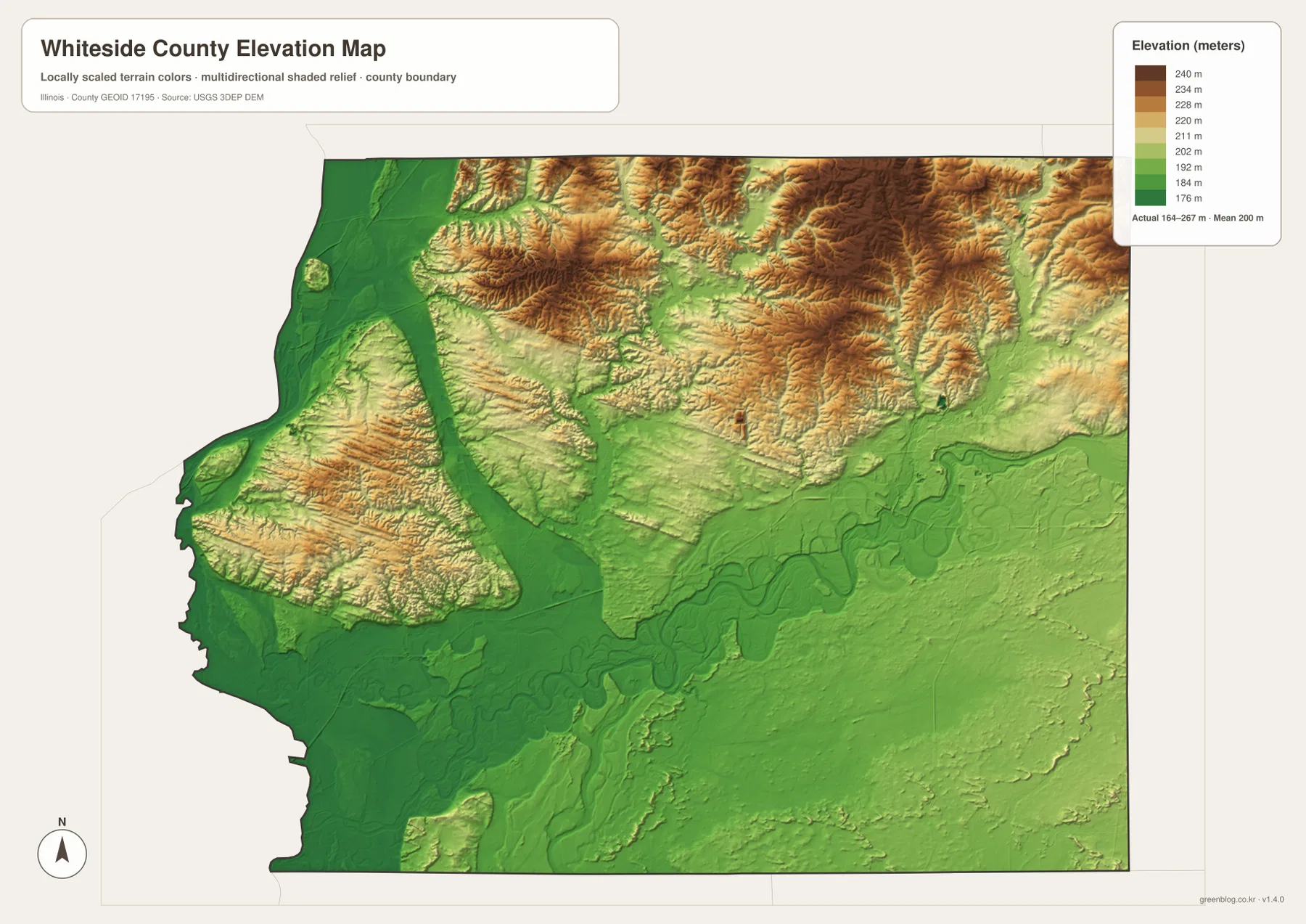
South of the Rock River, the terrain is generally smoother and lower than the northern hills, although it is not perfectly flat. Small rises remain around the southwest and within the broad green lowlands. Prophetstown and Erie therefore sit in a landscape that looks different from the hillier northern half, while Morrison lies closer to the transition between those two settings.
The shaded elevation surface is designed for county-scale comparison. It should not be treated as a survey-grade reading for a house lot, farm field, drainage structure, or engineering project. Exact site elevations require more detailed official data or field measurements. For ordinary map reading, the value of this layer is the clear contrast between northern ridges, the Rock River valley, and the low western river margin.
Choosing the map that fits the question
Use the general map when roads and place names need to be seen together. It is the most useful version for explaining how Sterling and Rock Falls connect with Morrison and how the route network continues toward Fulton, Prophetstown, Erie, and Tampico. The city map is better when the task is simply to compare the direction and spread of the six highlighted communities without the distraction of smaller roads and labels.
Choose the water and terrain map for the Rock River, Lake Carlton, the Green River, and the many northern creeks. Choose the elevation map when the key question is why the north looks more dissected while the Rock River corridor and western edge are lower. Looking at those two natural-feature maps together is especially useful because many of the green elevation valleys line up with the named waterways.
The WebP images on the page are sized for quick viewing online. The ZIP below contains the same map set as original high-resolution JPG files, each measuring 3638 × 2572 pixels. Those larger files are better for printing, placing into a presentation, or zooming in on labels that are small in the browser. Download the archive once, then use the map that best matches the geographic question rather than forcing every detail into one image.
Frequently Asked Questions
Which map is best for comparing Sterling, Rock Falls, Morrison, and Fulton?
Use the general map when roads matter because it shows the communities together with U.S. 30, I-88, and state routes. Use the city map when you only need their relative positions. Sterling and Rock Falls form the eastern cluster, Morrison is near the middle, and Fulton lies near the Mississippi-side boundary in the northwest. Neither map is intended to replace current navigation for driving time or route planning.
Where can I see the Rock River, Lake Carlton, and the northern creek network most clearly?
The terrain and water map is the clearest choice. It shows the Rock River across the central-southern county, Lake Carlton north of Morrison, and named creeks including Rock Creek, Spring Creek, Elkhorn Creek, Deer Creek, French Creek, Otter Creek, and Lynn Creek. It is a location reference only, so flood risk, water depth, and navigation conditions require separate official information.
Does the 164–267 m elevation map give exact site elevations?
No. The elevation layer is generalized for comparing county-scale relief. It clearly shows higher northern ridges and lower ground along the Rock River and western river edge, but it is not a survey or engineering product. Exact elevations for construction, drainage, or property work should come from detailed official elevation data or a professional field survey.
Map File Information
This ZIP contains the Whiteside County general map, city-distribution map, terrain and water map, and elevation map as original high-resolution JPG files. Review the web maps first, then use the larger originals for printing or detailed viewing.
- Included Files: 4 high-resolution JPG maps
- Printable Size: 3638 × 2572 px each
Related Maps
Sources and References
These official resources provide county information and background for the boundary, water, park, and elevation features represented on the maps.
- Whiteside County, Illinois — official county information
- Illinois DNR: Morrison-Rockwood State Park — official information about the park and Lake Carlton
- City of Sterling: About Sterling — local context for the Rock River and the county’s Mississippi River boundary
- U.S. Census Bureau TIGER/Line Shapefiles — county boundaries, roads, and geographic framework
- USGS National Hydrography — rivers, streams, and water features
- USGS 3D Elevation Program — elevation and terrain data
Green Map creates custom-edited map images using open geographic data sources such as geoBoundaries, Natural Earth, OpenStreetMap, and government open data.
These maps are edited visual materials, not raw data files, and are provided for education, documents, presentations, and graphic reference.