Download the high-resolution A3 JPG map ZIP for Saline County, Illinois directly from this page. The archive contains the same road-and-boundary, major-city, terrain-and-water, and elevation views shown below, while the embedded WebP images are sized for quicker browser reading. Saline County is especially useful to compare across these views because Harrisburg anchors a dispersed settlement pattern, the Saline River forks cut through broad lowlands, and the southeastern edge rises sharply into much higher ridges.
Start with Harrisburg near the center-south of the county. Eldorado sits to the northeast, Galatia to the northwest, and Carrier Mills and Stonefort to the southwest. Once those communities are familiar, the map becomes easier to read: Route 13 provides an east-west reference through Harrisburg, Middle Fork Saline River organizes the central drainage, and the elevation layer shows why the southeast looks so different from the broad green lowlands around the middle of the county.
Table of Contents
Harrisburg and Route 13 provide the main road reference
Harrisburg is the easiest place to locate on the general county map because it has the largest mapped built-up footprint and sits near two prominent numbered routes. Route 13 runs east and west, while Route 145 passes close by in a north-south direction. Muddy is labeled just north of Harrisburg and Raleigh farther north. To the east, Eldorado forms a separate northeastern center rather than a continuous extension of Harrisburg.
The other major communities are spread well beyond the central city. Galatia lies in the northwest, Carrier Mills southwest of Harrisburg near Route 45, and Stonefort close to the southwestern corner. Eldorado is associated with Route 142, and Route 34 appears near the southeastern side. The county therefore reads more clearly when each town is tied to a direction and a nearby route instead of trying to interpret the road network as one continuous urban grid.
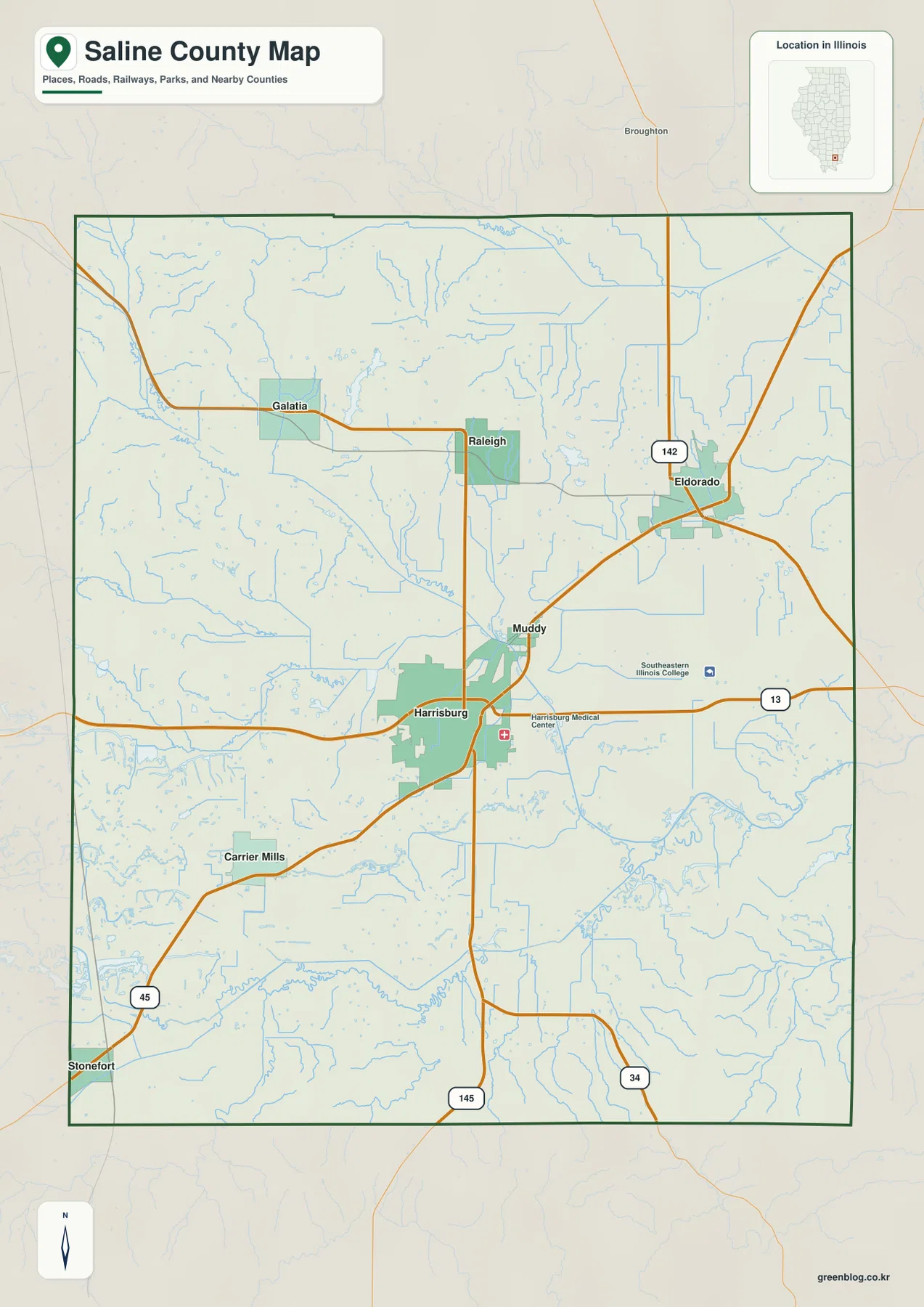
Road numbers reinforce the same pattern. Routes 13 and 145 make Harrisburg the easiest central anchor, Route 142 helps locate Eldorado, Route 45 is useful near Carrier Mills and Stonefort, and Route 34 marks part of the southeastern side. Following roads from one named community to another is more practical than memorizing each bend. This approach also makes the water and elevation maps easier to use because the towns provide recognizable reference points when road labels disappear.
The source material in the package also identifies Harrisburg as the current county seat and Raleigh as the early county seat. That history helps explain why both places remain useful labels even though their mapped size is very different today. Harrisburg stands out as the present center, while Raleigh appears as a small northern settlement. The contrast is a reminder that present settlement size and historic administrative importance do not always produce the same visual weight on a county map.
Six ranked communities are spread across the county
The city-index map removes most of the smaller roads and labels and highlights six principal communities. The supplied ranking places Harrisburg first, Eldorado second, Carrier Mills third, Galatia fourth, Stonefort fifth, and Raleigh sixth. Printed values are 8,372 for Harrisburg, 3,771 for Eldorado, 1,634 for Carrier Mills, 913 for Galatia, 422 for Stonefort, and 235 for Raleigh. These are described only as values printed on the supplied map, not as newly verified current population counts.
The positions matter more than the ranking by itself. Harrisburg occupies the center-south, Eldorado is well to the northeast, and Carrier Mills is separated to the southwest. Galatia and Raleigh share the northern half but remain distinct east-west reference points, while Stonefort sits near the southwestern edge. Connecting the six locations creates a broad, dispersed pattern rather than a compact metropolitan cluster. That distribution helps explain why the roads and drainage lines approach Harrisburg from several directions instead of serving one continuous urban belt.
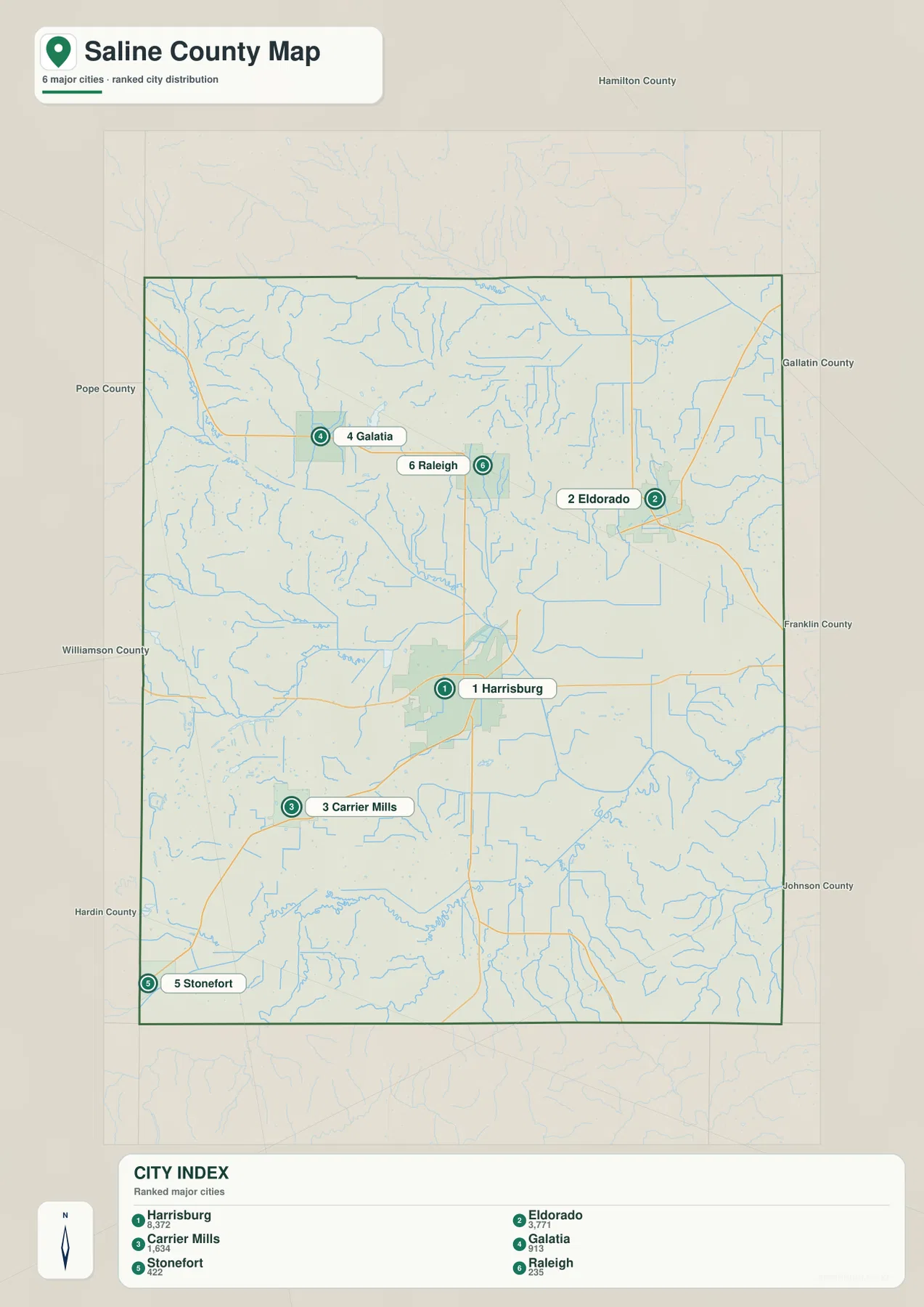
This simplified city view is best for comparing relative positions. The general county map is better when route numbers, smaller settlements, and the full boundary are needed. The city index quickly shows why Harrisburg is a central reference without implying that all other important places form suburbs around it. Saline County’s larger communities occupy clearly separated parts of the county.
Middle Fork and South Fork organize the water network
Middle Fork Saline River is the strongest organizing feature on the terrain-and-water map. It enters from the northwest, crosses the central portion of the county, and continues southeast toward the main Saline River label. Numerous smaller tributaries join it from both sides. Following that main channel first prevents the map from feeling like a tangle of unrelated creeks and makes the broad central drainage area much easier to understand.
The southern half contains a second set of major water references. South Fork Saline River runs across the south, while Little Saline River approaches from the southwest. Old Channel is labeled near the South Fork. Bankston Fork appears farther north and Long Branch near the northern part of the county. Grouping the waterways into northern, central, and southern systems is more useful than trying to memorize every small tributary name.
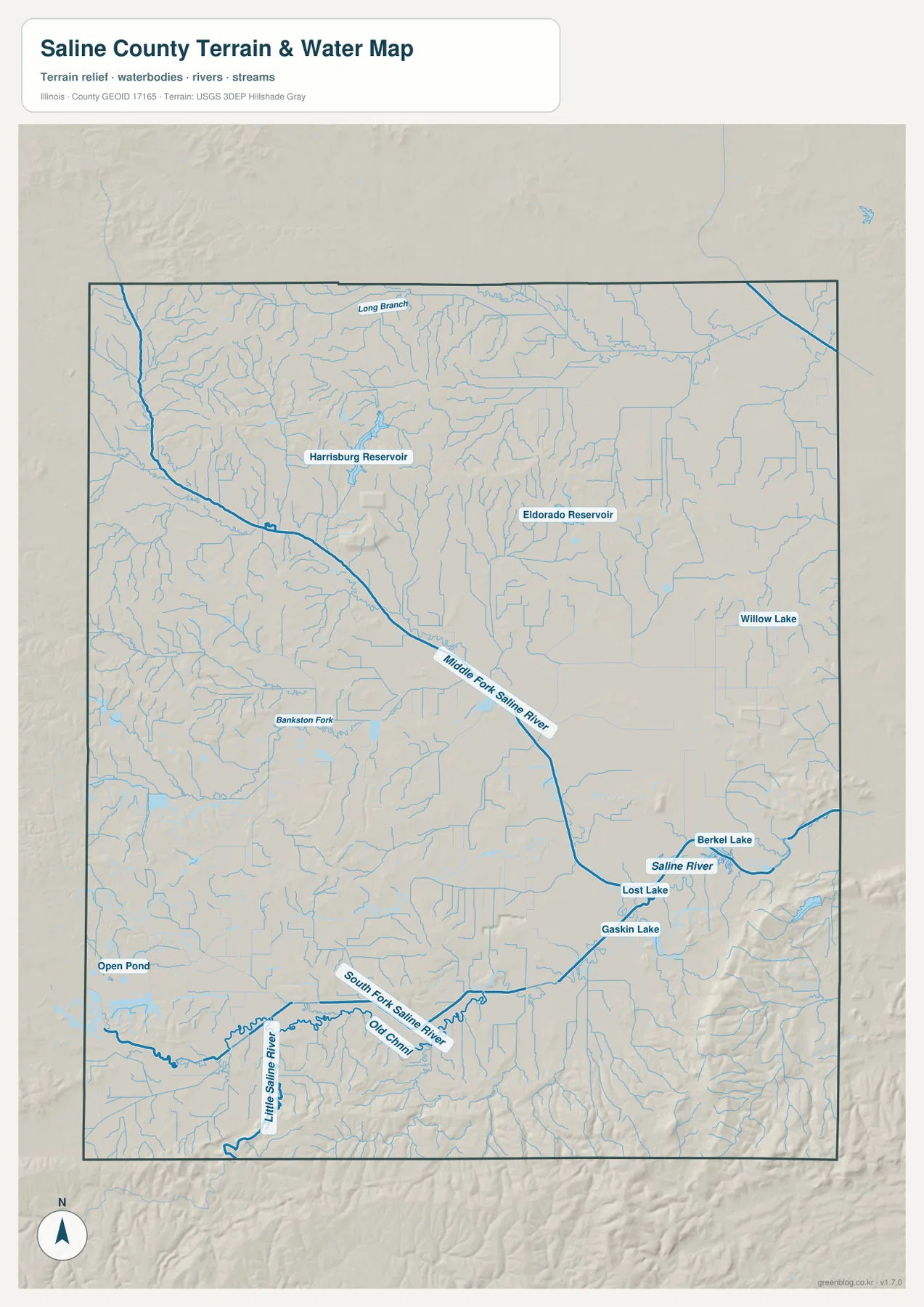
Named water bodies are spread across several parts of the county. Harrisburg Reservoir appears northwest of the central city area, Eldorado Reservoir farther east, and Willow Lake near the eastern side. Berkel Lake, Lost Lake, and Gaskin Lake cluster near the Saline River in the southeast, while Open Pond is separated toward the southwest. These locations show that standing water is distributed across multiple drainage areas rather than concentrated around one city.
The water map is a geographic reference, not a flood-hazard, parcel, water-quality, public-access, or navigation product. A mapped stream or lake does not prove a legal boundary, navigability, or a particular flood condition. Its value here is in comparing relative locations: which communities sit near the main forks, where reservoirs appear, and how those lower valleys correspond to the terrain colors on the elevation map.
The southeastern ridges rise from 62 to more than 300 meters
The supplied elevation layer reports an actual range of about 62 to 304 meters and a mean near 127 meters. Much of the central and northeastern county appears in green tones, indicating broad lower terrain. The strongest contrast is in the southeast, where tan and brown ridges rise sharply above the central lowlands. Higher ground also continues along parts of the southern edge, producing a county-wide elevation difference of more than 240 meters.
The northwest is not completely flat. Rolling and dissected terrain appears west and northwest of Galatia, with small stream valleys cutting between the higher areas. Even so, the southeastern ridges are much more prominent. On the water map, the Saline River and South Fork Saline River occupy lower corridors, and the elevation view shows similar green bands between higher terrain. Comparing the two maps makes the relationship between streams and lower valleys much easier to see.
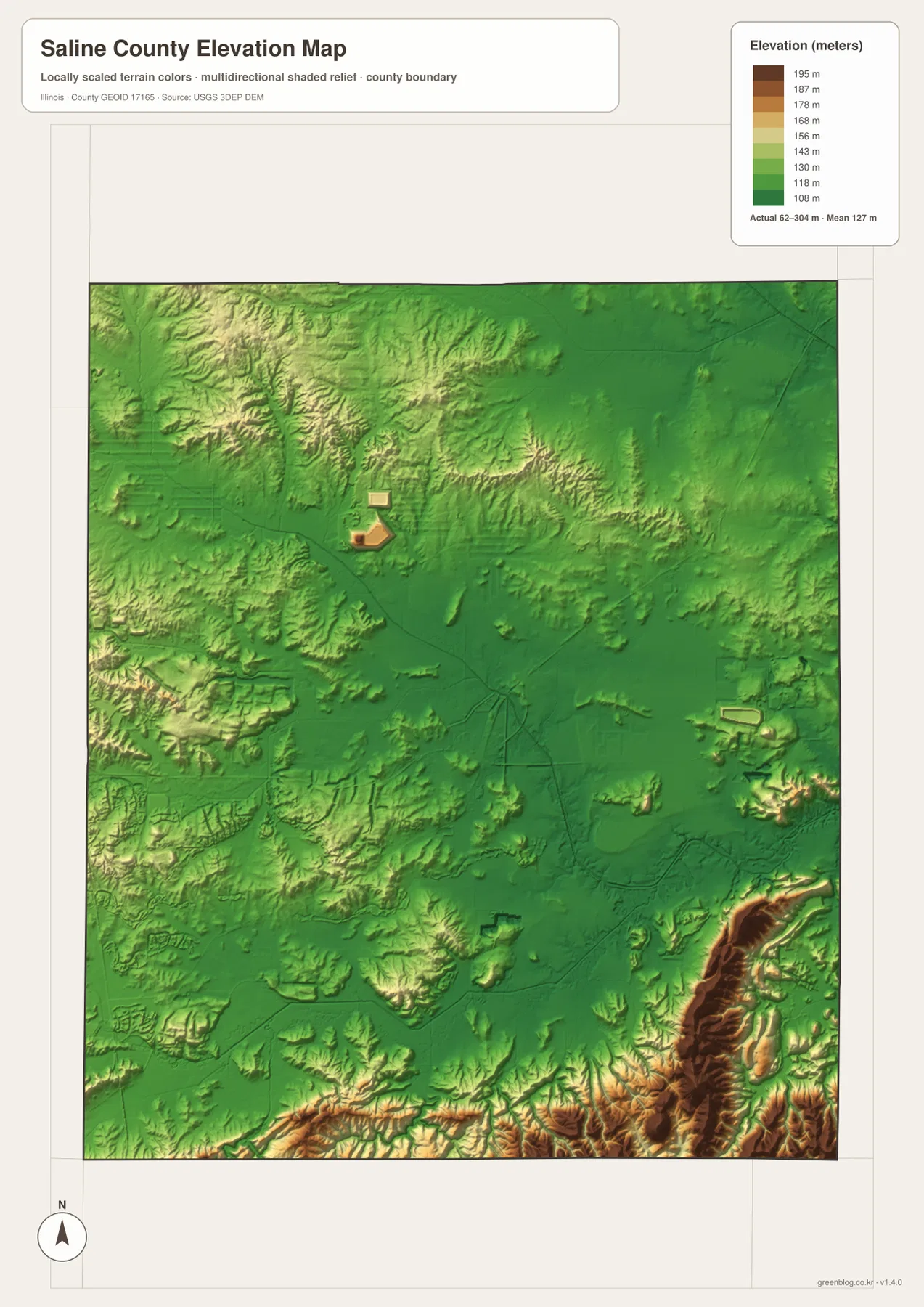
Putting the communities back on the terrain clarifies the pattern. Harrisburg and Eldorado lie close to the broad lower central and eastern areas. Moving south from Carrier Mills and Stonefort brings more broken, elevated terrain into view. Galatia is closer to rolling uplands in the northwest, but the strongest ridge colors still occur in the south and southeast. The elevation map therefore adds a physical explanation to the dispersed road and water pattern shown elsewhere on the page.
This elevation layer is designed for county-scale comparison, not parcel surveying or engineering. The 62–304 m range is useful for identifying broad lowlands, stream valleys, and higher ridges, but it should not be treated as an exact elevation for a specific address. Construction, drainage, legal property work, and detailed site planning require more precise and current source data.
Choose the view that matches the question
Use the general map when the question involves road numbers, county shape, or the full set of labeled communities. The city index is faster when only the six ranked places need to be compared. For rivers, reservoirs, and lakes, start with Middle Fork Saline River and then move to South Fork and Little Saline River. The elevation layer is most useful once those drainage lines are familiar, because the broad central lowland and higher southeastern ridges can then be compared directly.
The ZIP below contains four high-resolution JPG maps that match the views on this page. Each file is 2572 × 3638 pixels in portrait orientation, making small road numbers, stream names, and settlement labels easier to inspect or print than in the browser-sized WebP images. These maps are general reference products, so current road conditions, legal parcel boundaries, flood determinations, water-quality rules, navigation questions, or survey-grade elevations should be checked against the appropriate current official source.
Frequently Asked Questions
What is the easiest place to use as a starting point on the county map?
Harrisburg is the clearest starting point because it has the largest mapped built-up area and sits near Routes 13 and 145. From there, Eldorado is northeast, Carrier Mills southwest, and Galatia and Raleigh north of the central area.
Can Middle Fork and South Fork Saline River be seen on the same map?
Yes. The terrain-and-water map shows Middle Fork crossing the central county toward the Saline River and South Fork running across the southern half. Little Saline River and several reservoirs and lakes are also labeled.
What elevation range is shown for Saline County?
The supplied elevation layer reports an actual range of about 62 to 304 meters and a mean near 127 meters. The largest contrast is between the broad central lowland and the higher ridges along the southeastern and southern edges.
Map File Information
The ZIP contains high-resolution A3 JPG versions of the Saline County road-and-boundary map, major-city index, terrain-and-water map, and elevation map.
- Printable Size: 2572 × 3638 pixels each
- File Type: ZIP containing 4 JPG files
Related Maps
Sources and references
- Official Saline County website – county overview and government information
- Official Saline County history – Harrisburg and Raleigh background
- Illinois DNR Saline County State Fish & Wildlife Area – local natural and water reference
- U.S. Census Bureau TIGER/Line Shapefiles – boundary, road, and place reference
- USGS National Hydrography – rivers, streams, and lakes
- USGS 3D Elevation Program – elevation and terrain reference
Green Map creates custom-edited map images using open geographic data sources such as geoBoundaries, Natural Earth, OpenStreetMap, and government open data.
These maps are edited visual materials, not raw data files, and are provided for education, documents, presentations, and graphic reference.