Piatt County stretches north to south across east-central Illinois, with its communities spread widely rather than gathered into one continuous urban area. Monticello sits near the middle of the county and serves as the county seat, making it the easiest place to use as an orientation point. Mansfield lies far to the north, Bement and Hammond are south of Monticello, Cerro Gordo is toward the southwest, and Atwood occupies the southeastern edge. The road-and-boundary map establishes those relationships quickly, while the water and elevation maps explain another important part of the county: the Sangamon River crosses the central area through lower ground, and higher terrain becomes especially visible in the northeast.
This page is designed for visitors who want both a readable geographic overview and map files they can save for later use. The maps in the article show county boundaries and roads, the distribution of major communities, named waterways, and relative elevation. WebP images are used in the page for efficient viewing, while the download box near the end provides the corresponding high-resolution JPG files in one ZIP archive. Piatt County’s official facts page identifies Monticello as the county seat and describes a long, predominantly agricultural county; its published elevation range also fits the general relief shown by the supplied elevation map. Looking across the maps together gives a clearer picture than treating any one layer as a complete description of the county.
Table of Contents
Monticello as the reference point for roads and county shape
Monticello is the most useful starting point on the general county map. It appears close to the middle of Piatt County, near several road connections and the county courthouse symbols. From there, White Heath is to the north and east, De Land is west of the upper-middle part of the county, and Bement lies almost directly south. Mansfield is farther north near the northeastern side, while Cerro Gordo, Hammond, and Atwood define much of the southern spread of the county. Using Monticello first prevents the dense mix of local road numbers, streams, and boundary lines from becoming confusing.
The northern part of the map shows east-west routes labeled 150 and 74 near Mansfield. Farther south, the White Heath area is crossed by routes labeled 10 and 72. Rather than assigning a road class that is not needed for this article, the map can be read directly from those labels and their positions. The important geographic pattern is that strong east-west connections cross both the northern and central portions of the county, while a north-south route through the Monticello and Bement area helps tie the long county together. Cerro Gordo sits toward the western side of the southern half, and Atwood is close to the southeast edge, so the lower part of Piatt County opens in two directions away from the central Monticello-Bement line.
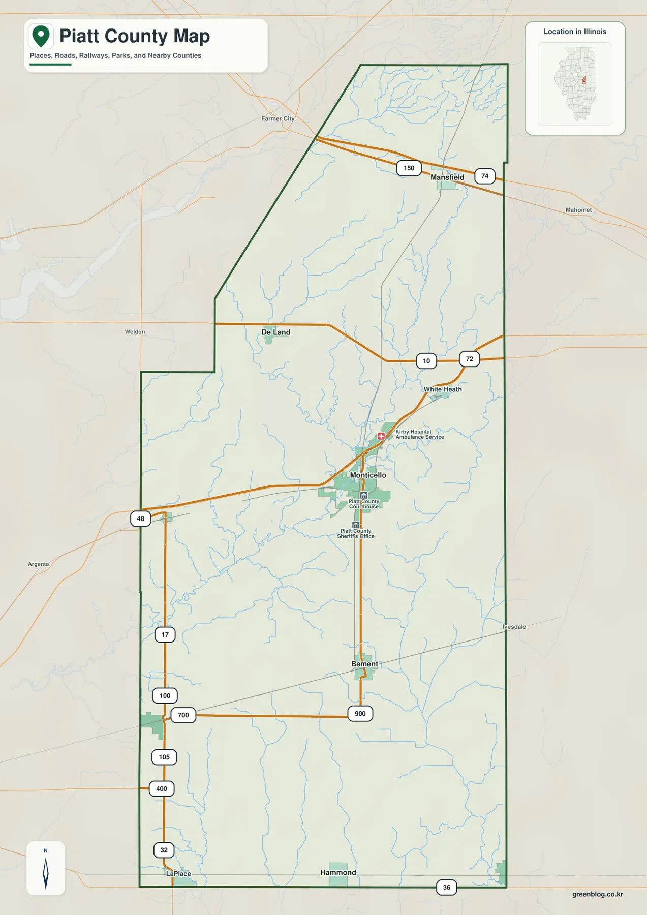
The county outline is also distinctive. Its western boundary steps inward across the middle, while the northern section narrows under a slanted northwest edge. The southern half is longer and more rectangular, carrying the county down past Bement toward Hammond and the Atwood area. Neighbor labels place De Witt and Macon counties to the west, Champaign and Douglas counties to the east, McLean County beyond the north, and Moultrie County toward the southwest. These surrounding names are useful for regional orientation, but the map should not be treated as a parcel survey or a source for legal boundary decisions.
Piatt County’s official information page confirms that Monticello is the county seat, which helps explain why the county map uses the city as a natural administrative reference. The courthouse and sheriff’s office symbols appear close to Monticello, while the other communities are spaced farther toward the county edges. For someone unfamiliar with the area, a practical reading order is Monticello first, Mansfield north, Bement south, Cerro Gordo west-southwest, and Atwood southeast. That simple sequence makes the county’s long shape and its road connections much easier to retain than a list of community names without geographic context.
Six major communities spread across a long county
The city map emphasizes six communities and ranks them by the population values printed in the map index: Monticello 6,304, Bement 1,792, Cerro Gordo 1,349, Atwood 1,144, Mansfield 866, and Hammond 617. Those figures are best read as the values attached to this particular map rather than as a substitute for a current population lookup. What matters most for the geographic picture is the strong difference between Monticello and the other five places, along with the distance separating the communities. Monticello is clearly the largest of the group and occupies the central position, while the smaller communities form a loose ring toward the north and southern edges.
Mansfield is isolated in the northern part of the county and is the northernmost of the six ranked communities. Bement is south of Monticello, and Cerro Gordo lies west of Bement near the western boundary. Atwood sits at the southeastern corner, while Hammond is close to the southern edge nearer the middle. The map therefore does not suggest a single dense corridor of settlements. Instead, Piatt County has one central community and several smaller places separated by broad areas between them. The surrounding county labels reinforce that pattern because several of these towns sit relatively close to an outer edge and face toward different neighboring counties.
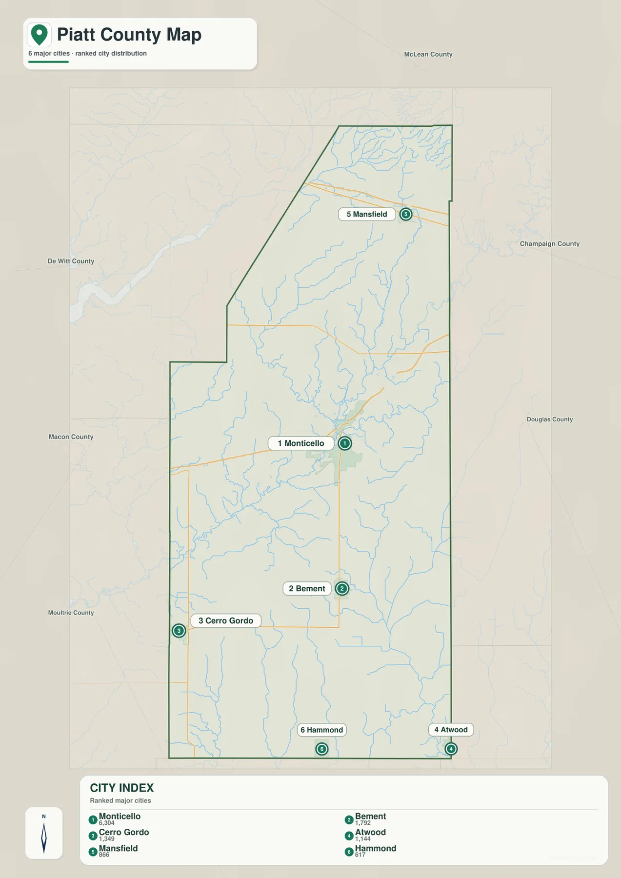
The ranked city layer also makes the road map easier to read. Monticello and Bement line up roughly north to south, but Mansfield and Atwood occupy very different ends of the county. Cerro Gordo shares the southern half with Bement while remaining much farther west, and Hammond sits near the bottom center. This matters when estimating direction from the map: two places that look similar in rank can be separated by a substantial part of the county. For classroom use or a printed regional reference, keeping the city map beside the road map helps distinguish settlement size from simple road prominence.
The general county map contains additional names such as De Land, White Heath, and LaPlace that are not highlighted among the six ranked city symbols. Those smaller reference points help bridge the gaps between the larger communities. White Heath is useful for locating the central-east road crossing north of Monticello, De Land marks the west-central part of the county near the stepped boundary, and LaPlace sits close to the southwestern edge. Together they show that the county is not empty between the ranked communities; the city-index map is a simplified view of the major places, while the general map provides more local detail.
The Sangamon River and a network of central tributaries
The terrain-and-water map is dominated by the Sangamon River, which runs diagonally across the central part of Piatt County. Goose Creek approaches from the northwest, Wildcat Creek is labeled to the west of the river, and Camp Creek joins from the east. Farther north, Madden Creek forms a separate, conspicuous channel near Lake Mansfield. These named waterways give the county a very different visual structure from the road map: instead of straight routes connecting towns, the center is organized around branching stream valleys that meet the main river at several points.
Smaller water features add detail to that picture. The map labels 4 H Lake near the central-western stretch of the Sangamon River, Trenkle Slough in the north, and Lake Mansfield near Madden Creek. It also shows long, straighter drainage features in the southern half, including West Main Ditch, Hammond Mutual Drain, and Unity No 3. Their shapes contrast with the more sinuous natural creeks in the north and center. Piatt County’s own county facts page describes the landscape as overwhelmingly agricultural, which provides useful background for understanding why named drains and ditches can appear alongside rivers and creeks on a county water map.
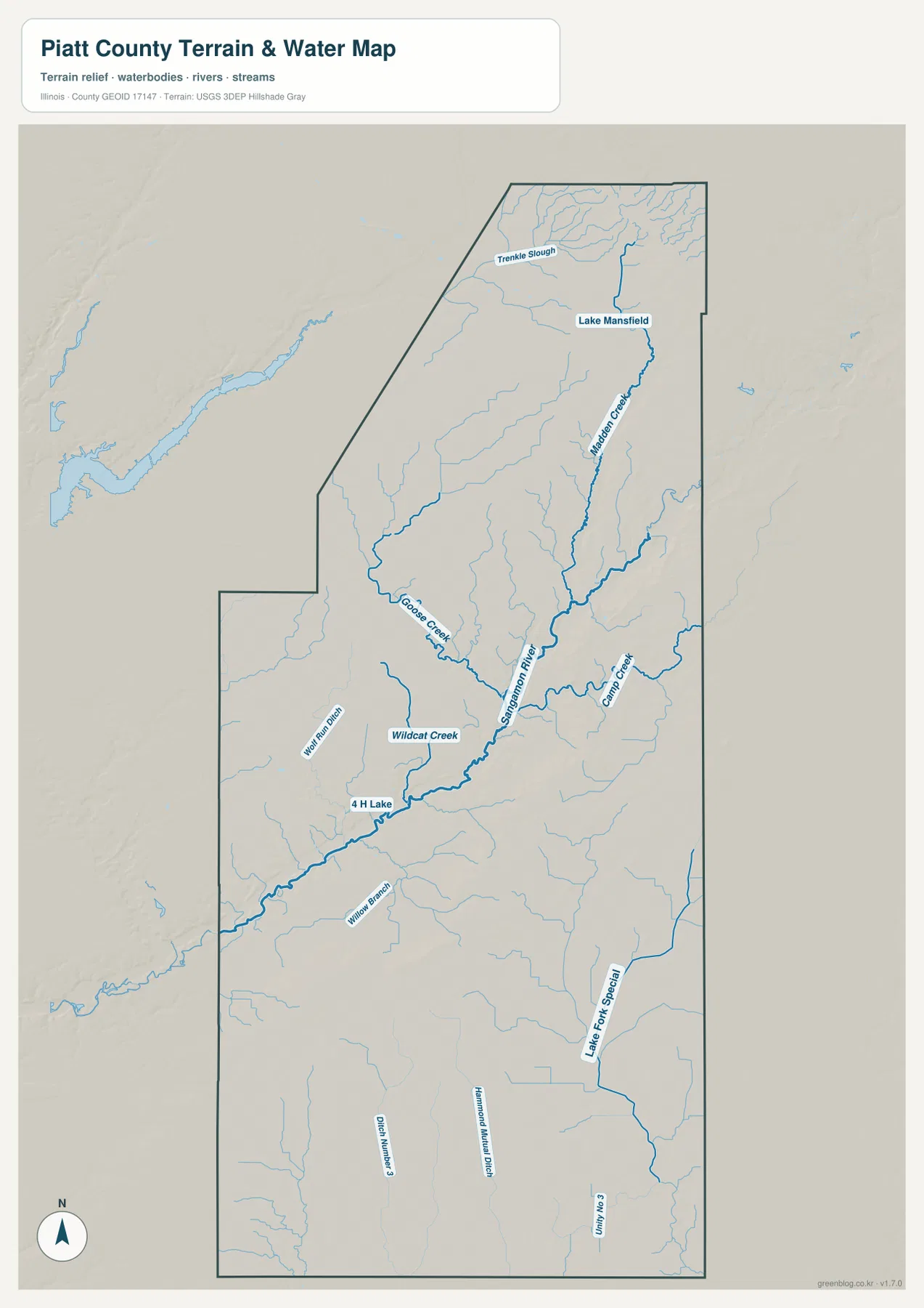
The southern half of the water map is especially useful for seeing the difference between winding stream courses and straighter drainage lines. Hammond Mutual Drain and Unity No 3 extend through areas south of the main Sangamon corridor, while smaller unnamed branches fill the spaces between them. This map does not establish who owns or maintains those drainage features, and it does not measure channel capacity. It simply shows the named water features and terrain reference supplied for the county. For flood zones, water quality, navigation, drainage engineering, or legal water boundaries, a purpose-specific official source is necessary.
When the water map is compared with the elevation map, the central river system becomes even more meaningful. The Sangamon River follows a broad low zone through the county, and many tributaries occupy narrow lower corridors feeding into it. That relationship is one of the clearest map-based features of Piatt County. The river is therefore not just another label in the middle of the page; it helps explain the shape of the relief and provides a geographic reference that links the northern creeks, central communities, and southern drainage features.
Northeast high ground within a 189–246 meter elevation range
The elevation map reports an actual county range of about 189 to 246 meters, with a mean near 212 meters. Piatt County does not contain mountain terrain, but the shaded relief still reveals meaningful differences. The highest colors are concentrated in the northeastern corner, while a broad green lowland traces the Sangamon River across the middle. The contrast is strongest where tributary valleys cut down from higher ground toward the river. This makes the central drainage system visible even without the blue water lines of the terrain-and-water map.
Additional higher patches appear south and east of the central river corridor, as well as in the southwest, but they are more localized than the northeast rise. Much of the southern and southeastern portion of the county remains in lower green tones. Madden Creek is especially noticeable because its valley cuts through the higher northeastern terrain before reaching lower ground. In the central portion, the Sangamon corridor broadens into a branching set of low valleys. The result is a county that looks relatively level on a road map but shows a clear pattern of ridges and drainage depressions when relief is added.
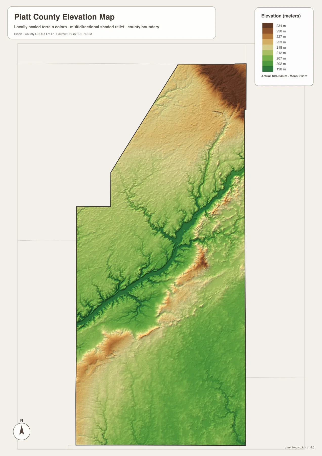
Piatt County’s official facts page gives a general elevation range of about 650 to 800 feet. Converted roughly to meters, that description is consistent with the overall range displayed on the map. The agreement is useful as a broad check, but the shaded surface is still a county-scale visualization rather than a survey product. It is appropriate for comparing parts of the county and explaining why streams occupy certain low areas. It should not be used to determine the exact elevation of a building site, road grade, drainage design, or property corner.
Settlement locations can also be viewed against the relief. Mansfield lies close to the northeastern higher area, while Monticello is nearer the lower central zone associated with the Sangamon River. Bement and Hammond occupy the generally lower southern half, and the Cerro Gordo side of the southwest is closer to one of the localized elevated patches. These are broad map relationships rather than precise site elevations, but they add useful context. A town that appears simply north or south on the road map gains a clearer physical setting when the elevation surface is considered at the same time.
Choosing the map that fits the question
A useful way to work with the set is to follow one place through the different layers. Start with Monticello on the county map to establish its road position and the surrounding communities. The city map then shows why it stands out among the six ranked settlements. On the water map, the central Sangamon system provides the nearby drainage context, and the elevation map shows that the river corridor is lower than the northeastern high ground. Following the same place from map to map turns four separate images into one coherent explanation of Piatt County.
Mansfield creates a different comparison. It is the northernmost of the ranked communities and sits near the east-west roads in the upper county. Lake Mansfield and Madden Creek appear nearby on the water map, while the elevation layer places the area close to the county’s strongest concentration of higher ground. Atwood, by contrast, is at the southeastern edge in generally lower terrain, and Hammond is near the southern boundary. These differences are visible without adding speculative history or land-use claims; they come directly from the supplied maps and make each community easier to place in the county as a whole.
For a printed reference, the general county map is the best choice when boundaries, roads, towns, and nearby counties all need to appear together. The city map is more efficient when the question is where the major communities are and how their displayed sizes compare. The water map is the clearest source for the Sangamon River, tributaries, lakes, and named drains, while the elevation map is the one to use when explaining the northeast rise and central lowland. Using two maps side by side is often more informative than trying to make one image answer every question.
These maps are intended for general geographic understanding rather than real-time or legally authoritative decisions. Traffic conditions, current population, flood hazards, parcel ownership, official property boundaries, and engineering-grade elevations require dedicated current sources. Within that limit, the set gives a detailed and practical overview of Piatt County’s communities, drainage, and relief. The downloadable archive contains the high-resolution JPG versions of the maps shown in the article, which makes it easier to print them, zoom into labels, or keep them together as a local reference.
Frequently Asked Questions
What is the easiest place to use as an orientation point in Piatt County?
Monticello is the clearest starting point because it is near the middle of the county and is also the county seat. From Monticello, Mansfield is north, Bement and Hammond are south, Cerro Gordo is toward the southwest, and Atwood is near the southeastern edge. The general county map gives the road context, while the city map makes the relative positions of the six major communities easier to compare.
What does the elevation map show about the Sangamon River?
The Sangamon River crosses a broad lower zone through the middle of Piatt County. On the elevation map, that corridor appears mainly in green and is lower than the higher northeastern corner. Tributaries such as Goose Creek, Wildcat Creek, and Camp Creek occupy additional low valleys that connect with the central drainage area. Viewing the water and elevation maps together is the simplest way to understand that relationship.
Which files are included in the Piatt County map download?
The ZIP contains four high-resolution JPG files: a county road-and-boundary map, a major-city distribution map, a terrain-and-water map, and an elevation map. Each image is 2572 × 3638 pixels. The web page uses smaller WebP images for convenient viewing, while the JPG files are better suited to larger displays or printing. The maps are general geographic references and should not replace legal surveys, flood studies, or engineering measurements.
Map File Information
The ZIP contains high-resolution JPG versions of the Piatt County road-and-boundary map, major-city map, terrain-and-water map, and elevation map.
- Printable Size: 2572 × 3638 px each
- File Type: ZIP containing 4 JPG images
Related Maps
Sources and References
- Piatt County, Illinois – County Courthouse & County Facts – county seat, county dimensions, land-use summary, and general elevation information
- City of Monticello, Illinois – official information for the county-seat community
- U.S. Census Bureau TIGER/Line Shapefiles – county boundaries, roads, and place references
- USGS National Hydrography – rivers, streams, lakes, and hydrographic references
- USGS 3D Elevation Program – terrain and elevation references
Green Map creates custom-edited map images using open geographic data sources such as geoBoundaries, Natural Earth, OpenStreetMap, and government open data.
These maps are edited visual materials, not raw data files, and are provided for education, documents, presentations, and graphic reference.