Download four high-resolution JPG maps of McHenry County, Illinois, in one ZIP from this page, then use the article views to compare Woodstock, Crystal Lake, McHenry, Harvard, Huntley, the major streams and lakes, and the county’s elevation. The settlement pattern is not evenly distributed. Crystal Lake, Algonquin, Lake in the Hills, and Huntley form a tight southeastern group, while Woodstock sits farther west and Harvard stands alone in the northwest. McHenry and Johnsburg occupy a separate northeastern lake-and-stream setting.
The physical landscape changes just as clearly. North and west of Woodstock, the elevation map shows broad high ground and rolling ridges. Eastward, Nippersink Creek, Wonder Lake, Pistakee Lake, McCullom Lake, and the Fox River occupy lower terrain. The county government describes McHenry County as a place where urban and rural lifestyles meet amid rivers, streams, trails, and open space, and the supplied maps show that contrast in a very concrete way. The actual elevation range is about 221 to 361 meters, with a mean near 266 meters.
Table of Contents
A Route 47 spine through Woodstock beside a denser eastern road network
Woodstock provides the clearest road reference in the middle-western part of the county. Route 47 runs north-south past the Woodstock area and continues toward Huntley in the south. Route 14 links the Harvard side of the county with Woodstock, while Route 176 crosses the southern half toward Crystal Lake. The McHenry County Courthouse marker sits near Woodstock, reinforcing the city’s role as a central reference even though several larger population centers lie farther east and southeast.
The eastern half carries a different road pattern. Route 31 runs through the Johnsburg-McHenry side and continues toward the Crystal Lake and Prairie Grove area. Route 120 crosses McHenry east-west, while Route 12 serves the Spring Grove side in the northeast. Harvard has Routes 173 and 14 nearby in the northwest. Marengo occupies the southwest around Routes 23 and 20. Together these roads show a county with a strong central north-south line around Woodstock but a much denser set of connections among the eastern communities.
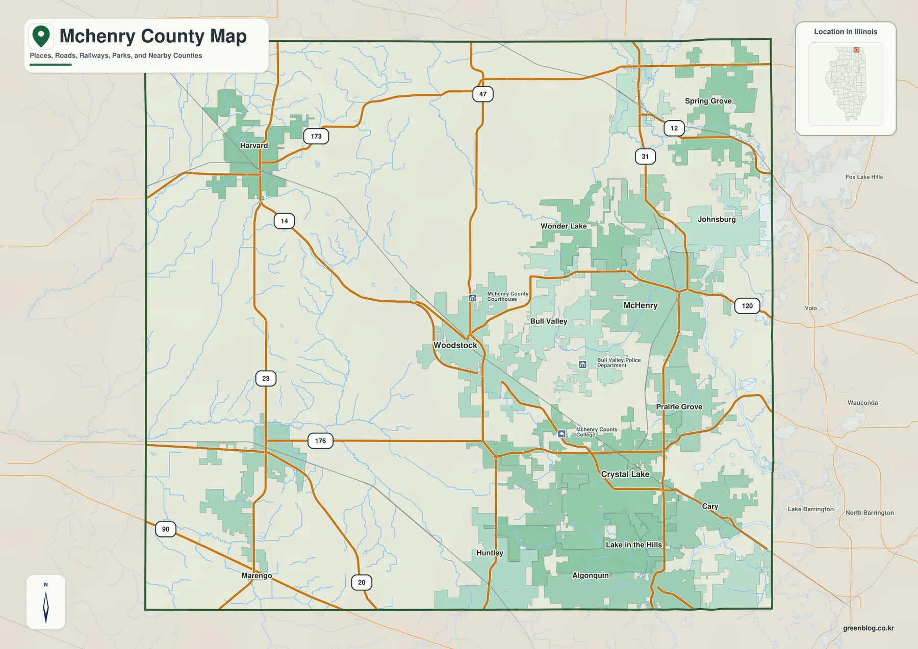
Southern McHenry County adds another contrast. Huntley, Algonquin, and Lake in the Hills are close enough to read as a connected southeastern urban area, with Crystal Lake immediately north of them. Marengo is much farther west and sits in a more open road pattern. The map is intended for geographic orientation rather than live navigation, so current travel times, traffic conditions, and road closures should still be checked with a dedicated road service.
The six largest highlighted places cluster south and east of Woodstock
The ranked city map lists Crystal Lake at 40,579, Algonquin at 30,067, Lake in the Hills at 28,800, McHenry at 28,074, Huntley at 28,005, and Woodstock at 26,147. The values are fairly close after Crystal Lake, but the locations reveal a stronger pattern. Crystal Lake, Algonquin, Lake in the Hills, and Huntley all occupy the southeast, while McHenry is farther north and Woodstock sits apart to the west.
Crystal Lake, Lake in the Hills, and Algonquin are especially close together on the map. Huntley extends that concentration toward the southwestern corner of the southeastern urban zone. McHenry is separated from them by more open land and water features to the north, while Woodstock marks a distinct central-western community. The city map therefore shows a clear population concentration without needing the road labels that make the general county map busier.
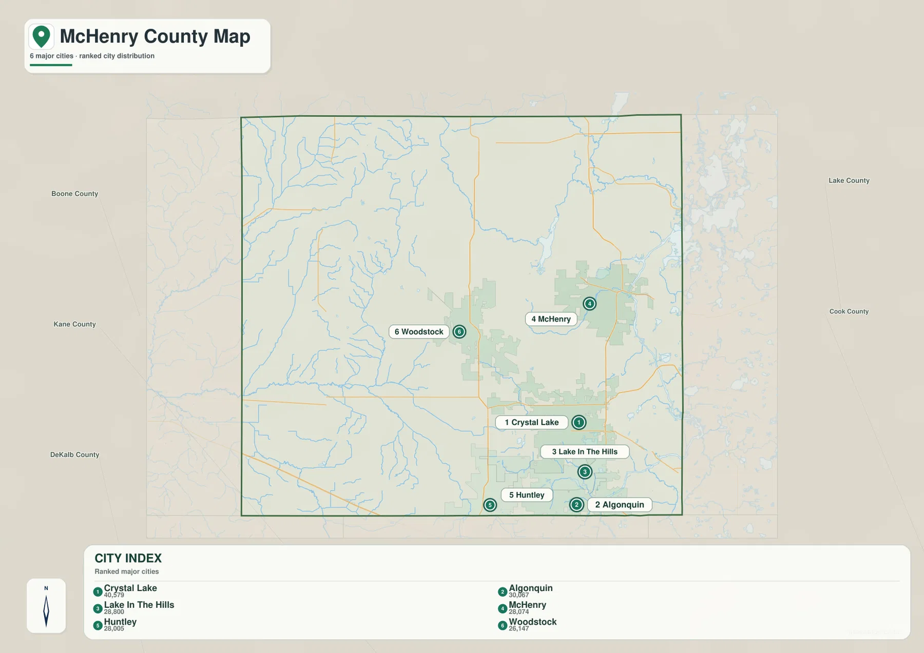
The county map fills in the places that the ranked view leaves out. Harvard anchors the northwest, Marengo the southwest, and Spring Grove and Johnsburg the northeast. That broader context matters because the six largest highlighted places do not represent the county’s full settlement pattern. Using both maps makes it easier to see where development is concentrated and where towns are separated by larger stretches of open land.
Kishwaukee headwaters in the west meet a lake-and-river landscape in the east
The terrain and water map divides McHenry County into two very different water settings. In the west and central-west, North Branch Kishwaukee River and South Branch Kishwaukee River cross a network of smaller streams, including Rush Creek. The waterways thread through rolling ground rather than a broad lake basin. Their valleys are easy to trace on the elevation map because they cut narrow green corridors into the higher western terrain.
The eastern side is much more lake-oriented. Nippersink Creek winds toward Wonder Lake in the north-central and northeastern part of the county. Farther east and south, Elizabeth Lake, McCullom Lake, Pistakee Lake, Griswold Lake, and Crystal Lake create a chain of distinct water landmarks. Fox River appears in the southeast, giving the lower eastern edge another major river reference. This combination of lakes, creek valleys, and the Fox River is one of the strongest geographic differences between eastern and western McHenry County.
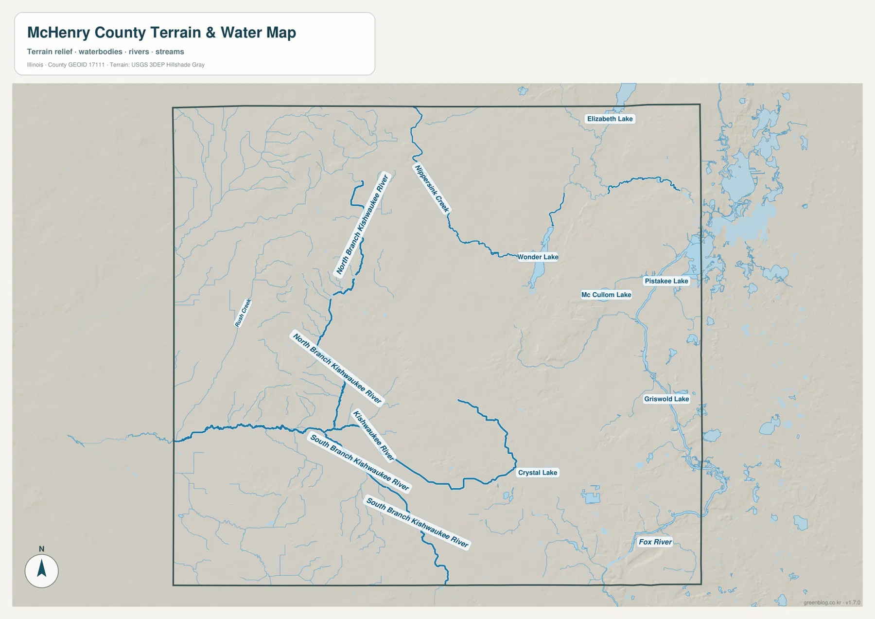
This map is a geographic water reference, not a flood-risk map, legal water-boundary product, navigation chart, or drainage-engineering document. Its main value is comparison. Place it beside the elevation map and the Nippersink-Fox River side lines up with broad lower terrain, while the western Kishwaukee tributaries cut through higher hills and ridges.
A 221–361 m landscape that falls from western ridges toward the eastern lakes
The elevation map reports an actual range of about 221 to 361 meters and a mean near 266 meters. The highest brown terrain occupies broad parts of the west and northwest, including long ridges south of Harvard and northwest of Woodstock. Smaller high areas also stand out in the west-central part of the county. The terrain is rolling and dissected by small streams, so the high country does not form one smooth plateau.
Eastern McHenry County is noticeably lower. Green terrain spreads around Nippersink Creek, Wonder Lake, Pistakee Lake, McCullom Lake, and the eastern lake country. The southeast becomes lower again toward the Fox River. Crystal Lake, Algonquin, and the surrounding communities occupy mostly middle elevations, with the terrain dropping into the river and creek valleys nearby. This west-to-east contrast is stronger than a simple north-to-south slope.
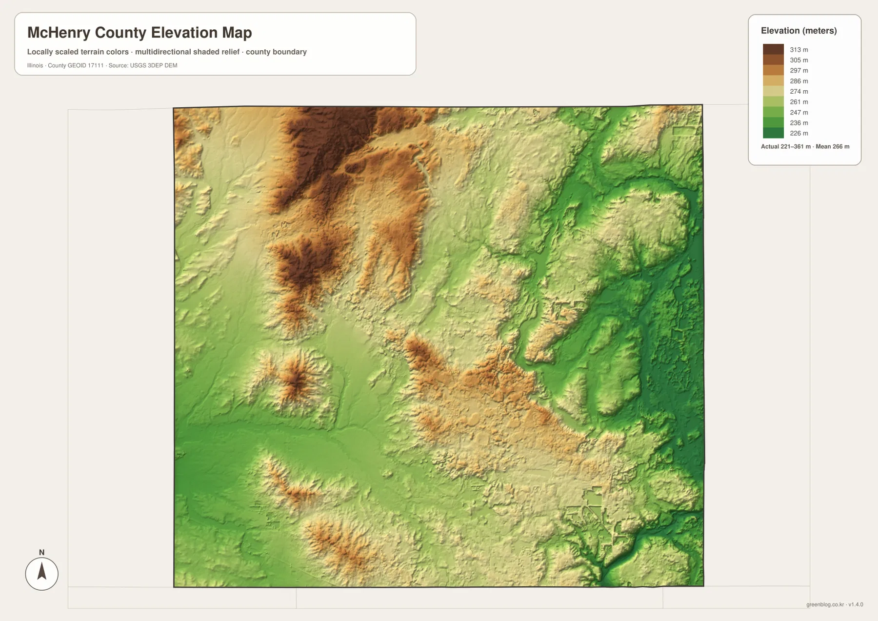
The elevation surface is generalized for county-scale comparison and should not be treated as survey-grade height, parcel elevation, or engineering data. For ordinary map reading, however, it explains much of the water map. The eastern lakes and major creek corridors occupy lower ground, while the western branches of the Kishwaukee system descend through higher terrain toward their valleys.
Follow Woodstock, Crystal Lake, and McHenry across the four views
Use the county map when roads, smaller settlements, the courthouse marker, and the full boundary matter most. The ranked city map is better for comparing Crystal Lake, Algonquin, Lake in the Hills, McHenry, Huntley, and Woodstock without extra road detail. The terrain and water map is the clearest source for Wonder Lake, Nippersink Creek, Fox River, the Kishwaukee branches, and the named lakes, while the elevation map explains the high western terrain and lower eastern corridors.
Woodstock is a good place to trace through all four views. The county map shows Route 47 and the city’s central-west position, while the ranked city map places it apart from the southeastern cluster. The water map shows the Kishwaukee system around the western half, and the elevation map highlights the higher ridges west and northwest of Woodstock. Crystal Lake and McHenry provide the opposite comparison because both are closer to the eastern lake-and-river side and the county’s largest concentration of developed communities.
Frequently Asked Questions
Why do Crystal Lake, Algonquin, and Lake in the Hills look so close together on the city map?
All three are concentrated in the southeastern part of the county, and Huntley extends that developed area farther southwest. The general county map also shows a denser road and settlement pattern there than in much of the west and northwest. McHenry sits farther north and Woodstock farther west, so the six highlighted cities form more than one geographic group rather than one evenly spaced line.
Which map is best for comparing Wonder Lake, Fox River, and the Kishwaukee River branches?
The terrain and water map is the best choice. Wonder Lake and Nippersink Creek are in the north-central and eastern side, Fox River appears in the southeast, and North Branch and South Branch Kishwaukee River occupy the west and central-west. Pistakee Lake, McCullom Lake, Crystal Lake, and other named lakes provide additional landmarks on the eastern side.
What files are included in the downloadable ZIP?
The ZIP contains four high-resolution JPG files: the county and road map, ranked city map, terrain and water map, and elevation map. Each image is 3638 × 2572 pixels. Smaller WebP versions are used in the article for faster viewing, while the JPG files are better for close inspection and print. The water and elevation maps are general geographic references rather than flood, legal-boundary, survey, or engineering products.
Map File Information
Download the McHenry County county map, ranked city map, terrain and water map, and elevation map together as high-resolution JPG files.
- Included Files: Use only the versions confirmed in the article and supplied images
- File Type: Use the confirmed download contents
- Intended Use: Printing, education, presentations, and map-based projects
Related Maps
Sources and references
- U.S. Census Bureau TIGER/Line Shapefiles – county boundaries, roads, and place reference
- USGS National Hydrography – rivers, streams, lakes, and other hydrography reference
- USGS 3D Elevation Program – elevation and terrain reference
- McHenry County Government – About Us – official county overview of its urban-rural mix, rivers, streams, trails, and open space
- McHenry County Yearbook – Facts to Remember – official county history and background
Green Map creates custom-edited map images using open geographic data sources such as geoBoundaries, Natural Earth, OpenStreetMap, and government open data.
These maps are edited visual materials, not raw data files, and are provided for education, documents, presentations, and graphic reference.