Download the Caribou County Map as one ZIP containing high-resolution A3 JPG versions of the county overview, city, terrain-and-water, and elevation maps. The WEBP previews below let you check Soda Springs, Grace, Bancroft, major roads, Blackfoot Reservoir, the Bear River, and the mountain relief before opening the larger files for printing, classroom work, reports, or presentations.
Caribou County in southeastern Idaho combines broad high valleys with reservoirs, river corridors, and rugged mountain belts. Soda Springs and Grace occupy the more open southern and central part of the county, while the eastern half becomes much more mountainous and is cut by the Blackfoot River and many smaller tributaries. Blackfoot Reservoir dominates the north, and the Bear River gives the southern map another strong geographic reference point.
Table of Contents
Soda Springs is the easiest reference point for the county
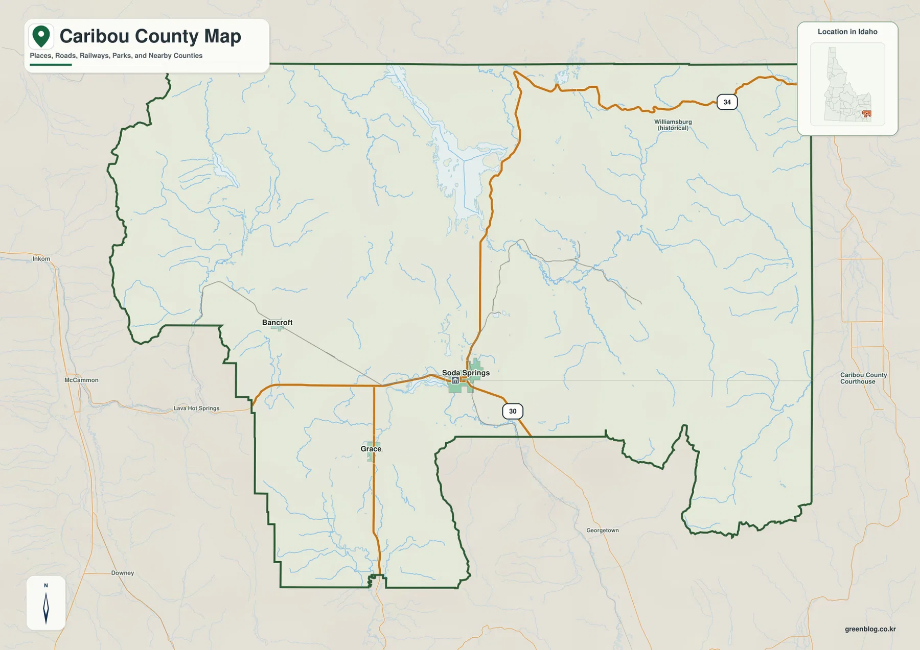
The county overview places Soda Springs a little south of the center, near the junction of important roads and waterways. The Idaho Blue Book records that Caribou County was established on February 11, 1919, with Soda Springs as the county seat, and describes it as the last county created in Idaho. The map also labels the Caribou County Courthouse in Soda Springs, making the administrative center easy to identify.
Grace lies southwest of Soda Springs, while Bancroft sits farther west. Route 30 crosses the southern-central part of the county through the Soda Springs area, and Route 34 leads toward the northeastern mountains and the Wyoming side of the region. The historical Williamsburg label appears in the northeast, where the county boundary bends repeatedly instead of following a simple rectangular outline.
Neighboring counties help orient the broader setting. Bannock County lies to the west, Bingham and Bonneville counties are to the north, and Bear Lake and Franklin counties are southwest of Caribou County. Because the populated southwest and central areas look very different from the mountain country in the east, learning the county outline first makes the other map views easier to follow.
The city map reduces the county to three clear reference points
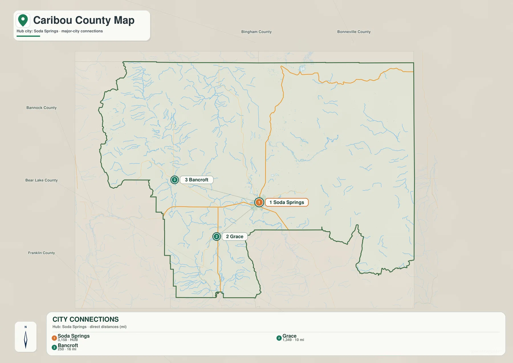
The city-connections map highlights Soda Springs, Grace, and Bancroft. Soda Springs is the hub, Grace lies southwest, and Bancroft lies west. The supplied graphic labels the straight-line distance from Soda Springs to Grace at about 10 miles and to Bancroft at about 16 miles. These are direct point-to-point distances on the map, not road-driving distances.
The simple city layout also shows how unevenly settlement is distributed. Soda Springs and Grace occupy the more open southern part of the county, while Bancroft stands near the western edge. Much of the large eastern half has no major city marker at all; mountain ridges, river valleys, and tributaries dominate that area instead.
For a quick location check, this is the easiest map to use first. After finding the three towns, the county overview can be used to add Route 30, Route 34, neighboring counties, and the detailed boundary shape. The city map is also useful in classrooms because the limited number of labels makes direction and relative distance easy to explain.
Blackfoot Reservoir, Bear River, and mountain tributaries define the water map
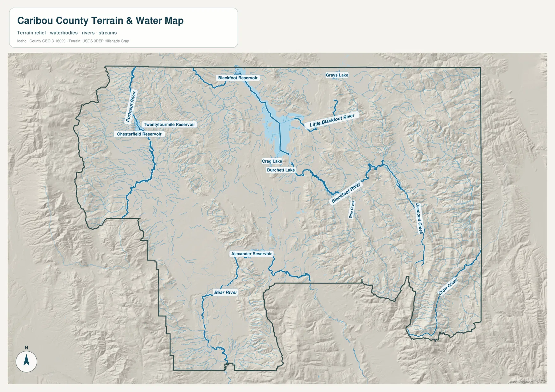
Blackfoot Reservoir is the largest labeled water body in the northern part of the terrain-and-water map. Little Blackfoot River extends away from it toward the southeast, while the Blackfoot River runs through the eastern mountain country. Slug Creek and Diamond Creek are among the named tributaries in that section, where the drainage network becomes much denser than it is on the broad central ground.
On the western side, the Portneuf River runs through mountain-and-valley terrain near Chesterfield Reservoir and Twentyfourmile Reservoir. South of Blackfoot Reservoir, Crag Lake and Burchett Lake provide smaller water landmarks. Their positions help separate the northern reservoir basin from the lower country around Soda Springs and Grace.
The Bear River crosses the southern part of the county near Grace, with Alexander Reservoir nearby in the central-southern valley. Crow Creek is labeled in the southeast, and many smaller streams descend from the surrounding high ground. This map is intended for geographic reference only; it is not a flood-hazard map, depth chart, navigation product, parcel map, or legal water-right document.
The highest terrain lies along the eastern and western mountain margins
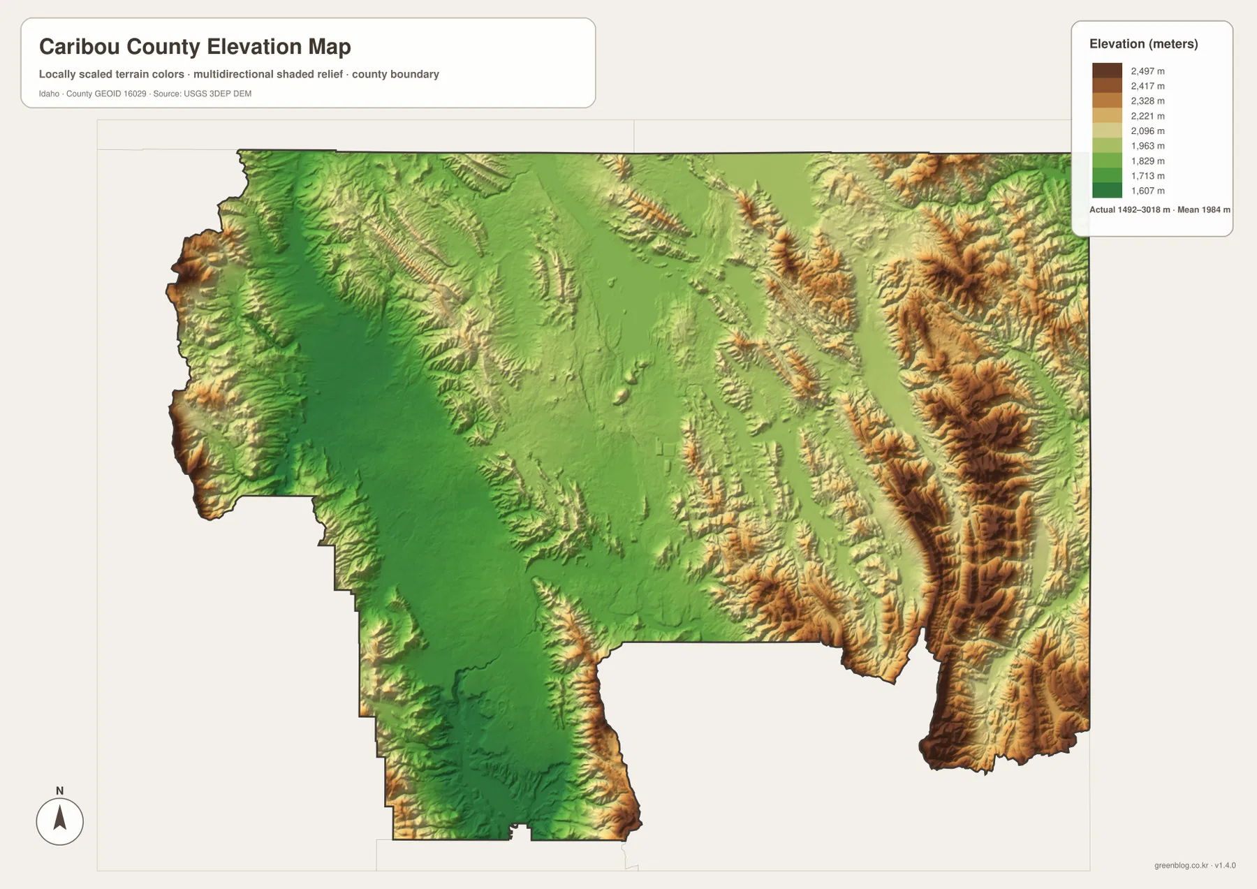
The elevation map shows broad green areas across much of the central and southwestern county, while the eastern and far western margins rise into yellow, tan, and brown mountain terrain. The strongest high-relief belt runs north-south through the east, matching the rugged river and creek pattern visible on the terrain-and-water map.
The supplied elevation graphic reports an actual range of about 1,492 to 3,018 meters, with a mean near 1,984 meters. Soda Springs and Grace sit in lower, more open country compared with the eastern mountains, and the northern Blackfoot Reservoir lies in a gentler basin between higher ground. Several western ridges also climb sharply above the broad interior.
The colors are designed for county-scale comparison rather than site-specific measurement. They are useful for seeing where the land rises and how valleys fit between mountain blocks, but a property survey or engineering project would need a more precise elevation source. For general map use, the contrast between the central valleys and the high outer ridges is the main point to notice.
Use the maps together to connect towns, water, and relief
For ordinary orientation, start with the city map to locate Soda Springs, Grace, and Bancroft, then move to the county overview to add Routes 30 and 34 and the surrounding boundaries. If Blackfoot Reservoir, Bear River, or the mountain creeks are the main interest, the terrain-and-water map gives the clearest picture of how those features relate to the towns.
The elevation view adds the final layer. Soda Springs and Grace occupy lower, more open country, while the eastern side rises into long mountain ridges cut by tributaries. In a classroom or report, one place can be traced across all four views to compare settlement, roads, water, and elevation. The same approach also works for trip planning, presentations, and county-to-county comparisons.
Frequently Asked Questions
Where is Soda Springs on the Caribou County map?
Soda Springs is slightly south of the county center, near Route 30 and several waterways. It is the county seat and the easiest reference point for locating Grace to the southwest and Bancroft to the west.
Where is Blackfoot Reservoir?
It is a large water body in the northern part of the county. Little Blackfoot River extends southeast from the reservoir area, and smaller lakes and streams are shown nearby.
Which areas are highest on the elevation map?
The eastern mountain belt and the far western mountain margins are the highest areas. The central and southwestern valleys around Soda Springs and Grace are lower, and the map reports an overall range of roughly 1,492 to 3,018 meters.
Map File Information
The ZIP contains high-resolution A3 JPG versions of the Caribou County overview, city, terrain-and-water, and elevation maps.
- File Type: JPG files inside one ZIP archive
Related Maps
Sources and references
- Idaho Secretary of State — Idaho Blue Book, Caribou County
- Caribou County — Natural Resource Management Plan
- U.S. Census Bureau TIGER/Line Shapefiles
- USGS National Hydrography
- USGS 3D Elevation Program
Green Map creates custom-edited map images using open geographic data sources such as geoBoundaries, Natural Earth, OpenStreetMap, and government open data.
These maps are edited visual materials, not raw data files, and are provided for education, documents, presentations, and graphic reference.