Camas County Map files are available as a ZIP of high-resolution A3 JPG maps, with WEBP previews on the page for quick viewing. The maps make it easy to compare Fairfield and the broad Camas Prairie with the steep northern headwaters of the South Fork Boise River, including Big Smoky Creek, Little Smoky Creek, Camas Creek, reservoirs, roads, and elevation.
Camas County has a strong north-south contrast. Fairfield sits on the broad, lower Camas Prairie, while the northern half rises into deeply cut mountain country. The county comprehensive plan describes the prairie as a former lake bed and high plateau at the foot of the mountains, and that transition is visible across the road, water, and elevation maps.
Table of Contents
Fairfield sits on the broad floor of Camas Prairie
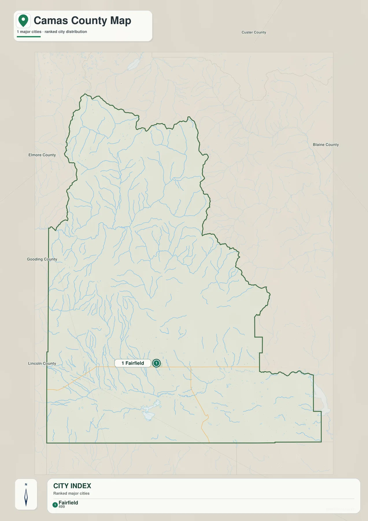
Fairfield is the clearest reference point on the county overview. Camas County and the Idaho Blue Book identify it as the county seat, and the map places it near the center of the wide southern plain. Roads are straighter and more closely spaced around the prairie than they are in the northern mountains, where valleys and ridges control the available routes.
The county outline is irregular and stretches far north from the prairie. Custer County lies to the north, Blaine County to the east, and Elmore County to the west, with Gooding and Lincoln counties along the southern side. This shape brings very different terrain into one county, from open lower land around Fairfield to rugged headwater country farther north.
The city map reduces the county to one main reference point
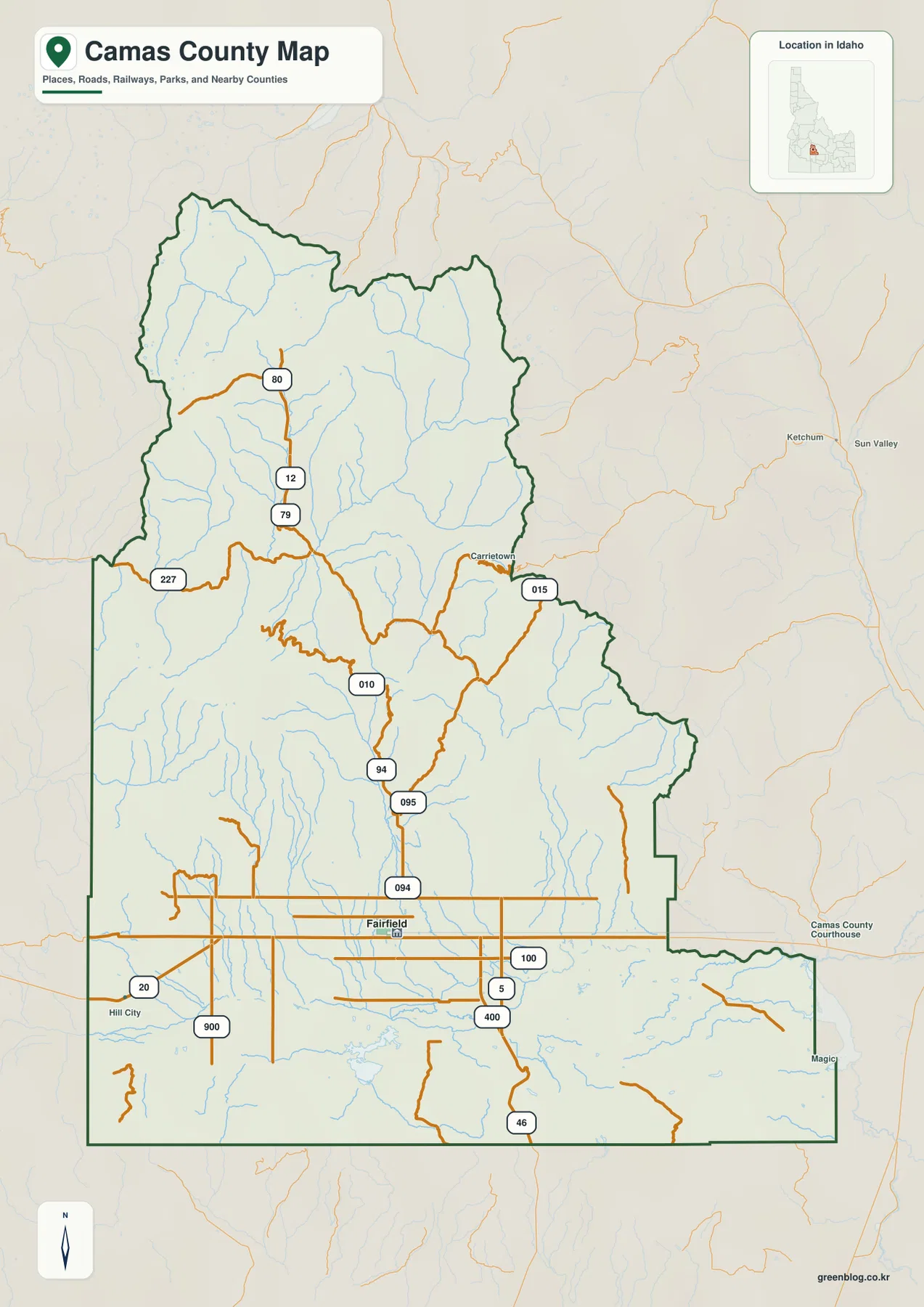
The supplied city map marks Fairfield as the single ranked major city in this package. That means it is not designed for straight-line distance comparisons between several cities, as some county city maps are. Instead, it gives a very clean picture of where Fairfield sits inside the much larger county boundary.
This simple distribution also reflects the rural character of the county. Most of the northern area is mountain terrain, while settlement and agriculture are concentrated on the prairie. The official county site describes Camas County as primarily agricultural and notes the Soldier Mountain area near the southern edge of the Sawtooth National Forest, a setting that helps explain why the county’s main settlement is on the lower land.
US 20 crosses the prairie while mountain roads follow the valleys
Camas County’s transportation study describes US 20 as the main east-west highway through the county, linking toward Mountain Home on the west and State Highway 75 in Blaine County to the east. On the county overview, the road pattern around Fairfield and the southern prairie is comparatively open and regular.
Farther north, the road network becomes much more constrained. Routes bend along river valleys and around steep ridges rather than crossing the terrain directly. Comparing the overview with the elevation map makes this difference easy to understand: the prairie provides broad low ground, while the headwater country is divided by high mountain blocks.
The water map separates Boise River headwaters from Camas Creek
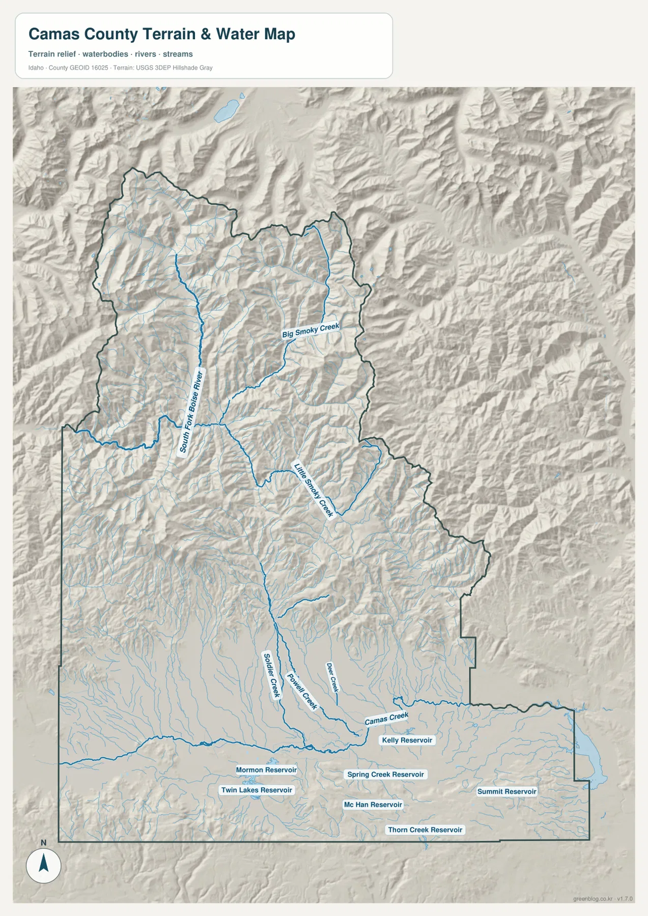
The northern drainage is dominated by the South Fork Boise River and its mountain tributaries. Big Smoky Creek and Little Smoky Creek are among the strongest labeled streams, descending through narrow valleys before joining the broader headwater system. The Camas County comprehensive plan also identifies these creeks as tributaries of the South Fork Boise River that drain the northern part of the county.
South of the mountain front, Camas Creek follows a very different setting across the prairie. Soldier Creek, Rock Creek, and Deer Creek feed into the lower network, and the stream pattern spreads across wider, gentler terrain. The contrast between the tightly branching northern headwaters and the broad southern drainage is one of the clearest geographic differences in the county.
The prairie also contains several named reservoirs, including Mormon Reservoir, Twin Lakes Reservoir, Spring Creek Reservoir, McHan Reservoir, Kelly Reservoir, Summit Reservoir, and Thorn Creek Reservoir. Their distribution gives the southern water map a very different appearance from the natural mountain tributaries in the north. This is a water-reference map for location and terrain context, not a flood-hazard, parcel, depth, or navigation chart.
Elevation rises sharply north of Camas Prairie
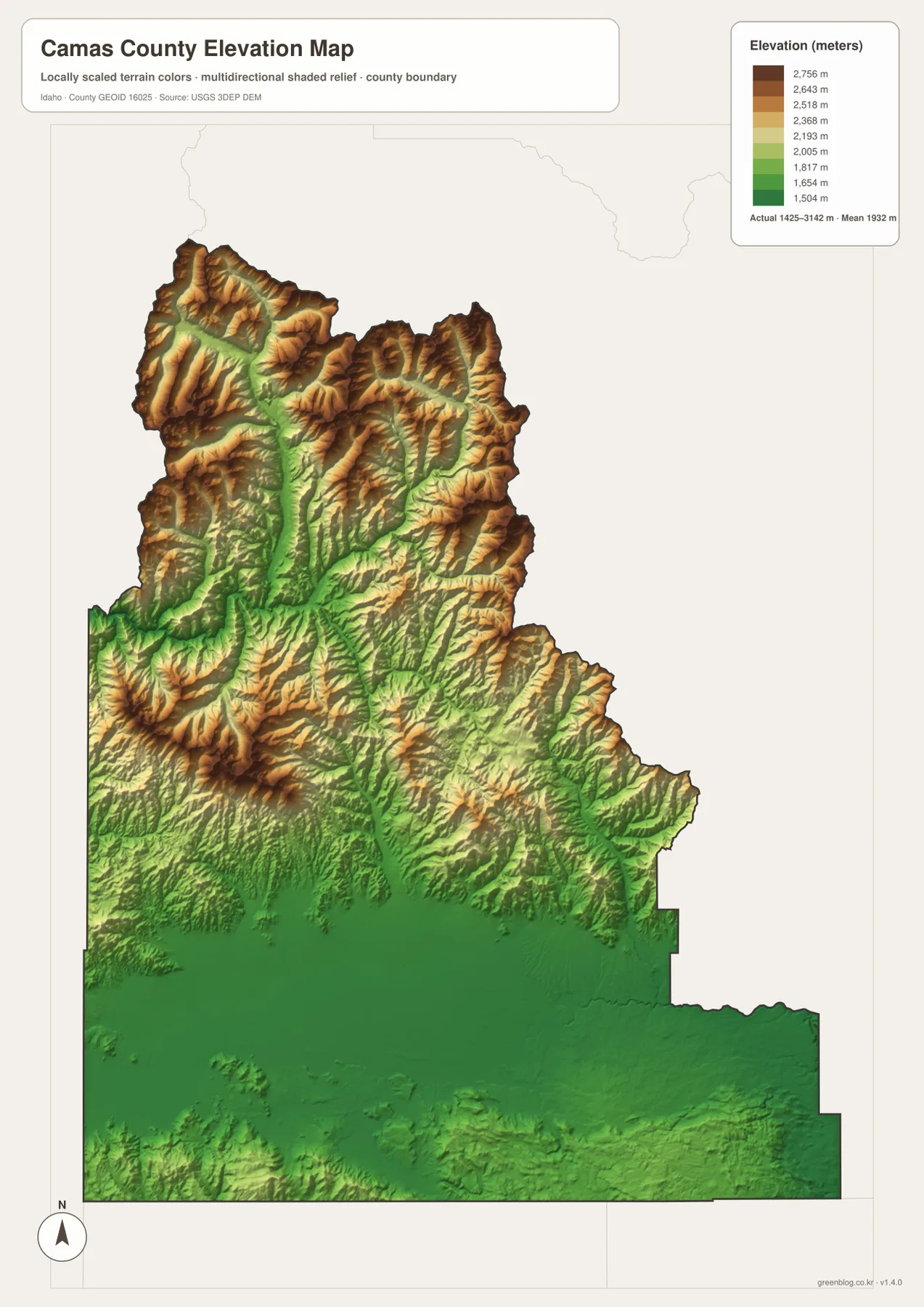
The elevation map makes the county’s topographic split unmistakable. Fairfield and most of the Camas Prairie appear in deep green, forming a broad low surface across the south. Moving north, the colors shift quickly through lighter green and yellow into tan and brown as the terrain climbs into steep ridges and narrow valleys.
The supplied map reports an actual elevation range of roughly 1,425 to 3,142 meters, with a mean near 1,932 meters. That puts more than 1,700 meters of vertical difference inside the county. The high country around the Soldier Mountain and Sawtooth National Forest direction rises immediately north of the prairie, matching the county’s official geographic description.
The color surface is intended for county-scale comparison rather than site surveying. It is useful for seeing which valleys are low and which ridges are high, but exact construction, engineering, or property measurements should rely on more precise elevation data.
Choose the map by whether you need settlement, water, or mountain relief
For Fairfield, US 20, and general county orientation, the overview and city map are the quickest starting points. The water map is better for tracing Big Smoky Creek, Little Smoky Creek, Camas Creek, and the reservoir cluster on the prairie. The elevation map is the clearest choice when the question is how abruptly the land rises from Fairfield into the northern mountains.
Using the views together is especially helpful because Camas County changes so much over a relatively short north-south distance. A reader can locate Fairfield first, follow the lower Camas Creek drainage across the prairie, then move north into the South Fork Boise River headwaters and compare how both the stream pattern and elevation change at the mountain front.
Frequently Asked Questions
Where is Fairfield on the Camas County map?
Fairfield is on the broad southern Camas Prairie and is the county seat. It lies in much lower, flatter terrain than the northern headwaters, so its position is easy to compare on the overview and elevation maps.
How do the northern and southern water systems differ?
The north is dominated by steep headwater valleys feeding the South Fork Boise River, including Big Smoky Creek and Little Smoky Creek. The south is centered on Camas Creek and a group of reservoirs spread across the flatter prairie.
What is the main feature of the elevation map?
The strongest feature is the jump from the low Camas Prairie to the high northern mountains. The map shows an actual range of about 1,425 to 3,142 meters, making it useful for regional relief comparison rather than exact site surveying.
Map File Information
The ZIP contains high-resolution A3 JPG versions of the Camas County overview, city, terrain-and-water, and elevation maps.
- File Type: JPG files inside one ZIP archive
Related Maps
Sources and references
- Camas County official website
- Camas County Comprehensive Plan
- Camas County Road & Bridge Transportation Planning Study
- U.S. Census Bureau TIGER/Line Shapefiles
- USGS National Hydrography
- USGS 3D Elevation Program
Green Map creates custom-edited map images using open geographic data sources such as geoBoundaries, Natural Earth, OpenStreetMap, and government open data.
These maps are edited visual materials, not raw data files, and are provided for education, documents, presentations, and graphic reference.