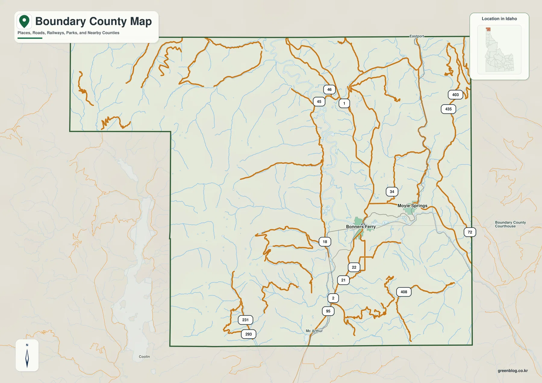
Boundary County Map files are available here as high-resolution A3 JPG maps in one ZIP, with WEBP previews for quick viewing in the page. The set focuses on Bonners Ferry and Moyie Springs, the Kootenai River valley, roads toward the Canada border, mountain streams, and the strong elevation contrast between the valley floor and the surrounding ridges.
Boundary County occupies Idaho’s far northern tip. Bonners Ferry sits in the lower Kootenai River valley, Moyie Springs lies to the east, and Eastport appears near the northern edge of the county. The maps make the county’s geography easy to compare: a broad river corridor runs through the center while higher mountain country rises on both sides.
Table of Contents
Use Bonners Ferry to orient the county
Bonners Ferry is the clearest place to use as a reference on the county overview. It lies in the Kootenai River valley near the middle of the main north-south corridor, while Moyie Springs is east of it and closer to the foothills. Eastport is labeled at the northern edge, helping show how the county reaches all the way to the international border.
The county outline is irregular rather than rectangular. A long northern section reaches west toward the state line, while the broader southern and eastern part contains the central Kootenai valley and large mountain blocks. Once the river corridor is located, the surrounding roads and smaller streams are much easier to place.
Bonners Ferry and Moyie Springs form the main city pair
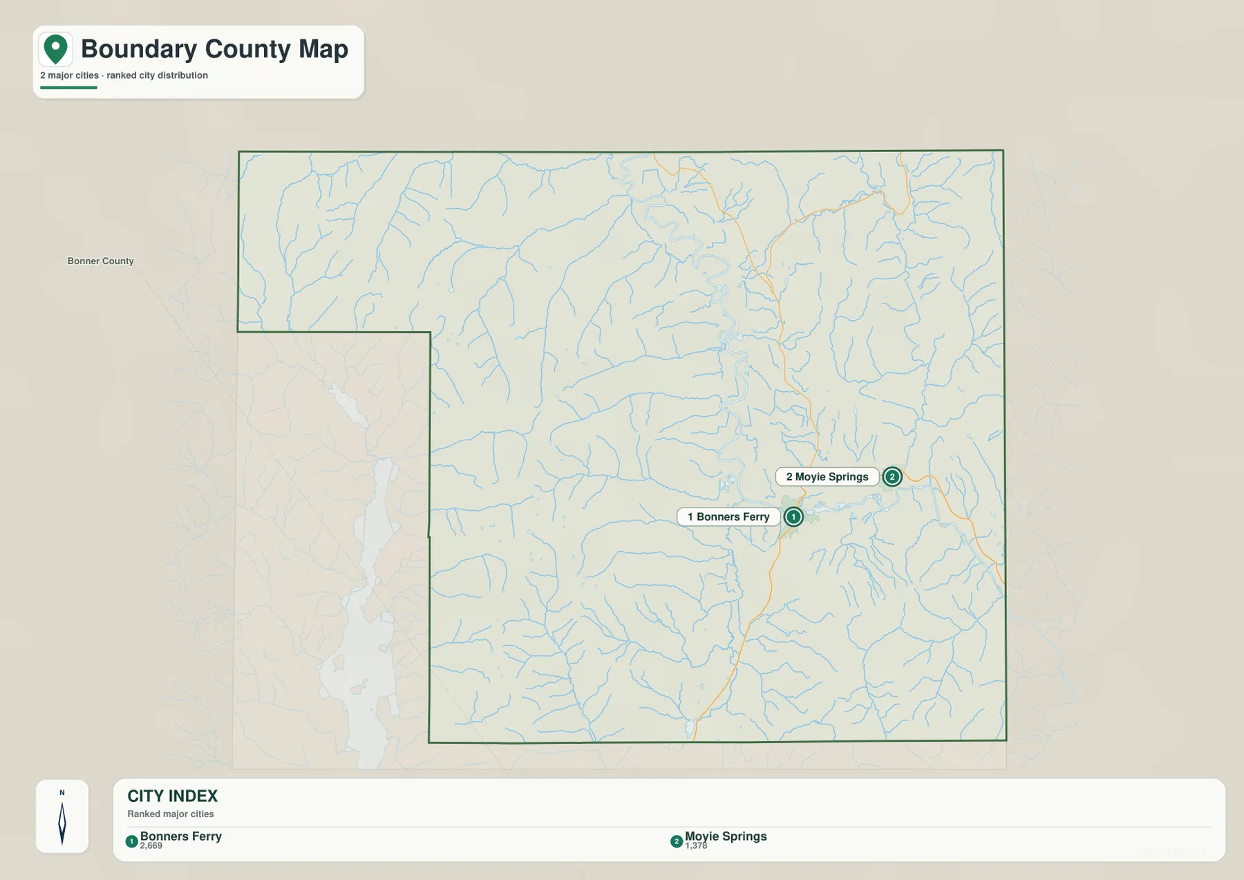
The city map highlights only two major incorporated places: Bonners Ferry and Moyie Springs. Bonners Ferry ranks first in the supplied city index and Moyie Springs second. Keeping the map this simple makes the east-west relationship between the two communities especially easy to see.
Bonners Ferry occupies the lower central valley, while Moyie Springs sits farther east where the terrain begins to rise. The city view is useful for basic orientation before moving to the road and water maps, but it should not be used to estimate driving distance or travel time between the two communities.
US 95 follows the county’s main north-south corridor
US 95 is the easiest highway to follow on the overview. It enters from the south, passes the Bonners Ferry area, and continues north toward the border. Boundary County’s official comprehensive plan describes Highway 95 as following the historic Wild Horse Trail corridor, which helps explain its long-standing role as the main north-south route through the county.
East of Bonners Ferry, roads climb toward Moyie Springs and the mountain terrain beyond. Farther north, the route network becomes more closely tied to the narrow valleys that reach the border. Comparing the road map with the relief map shows why major routes tend to follow river valleys rather than crossing the highest ridges directly.
Kootenai River and Moyie River define the central water system
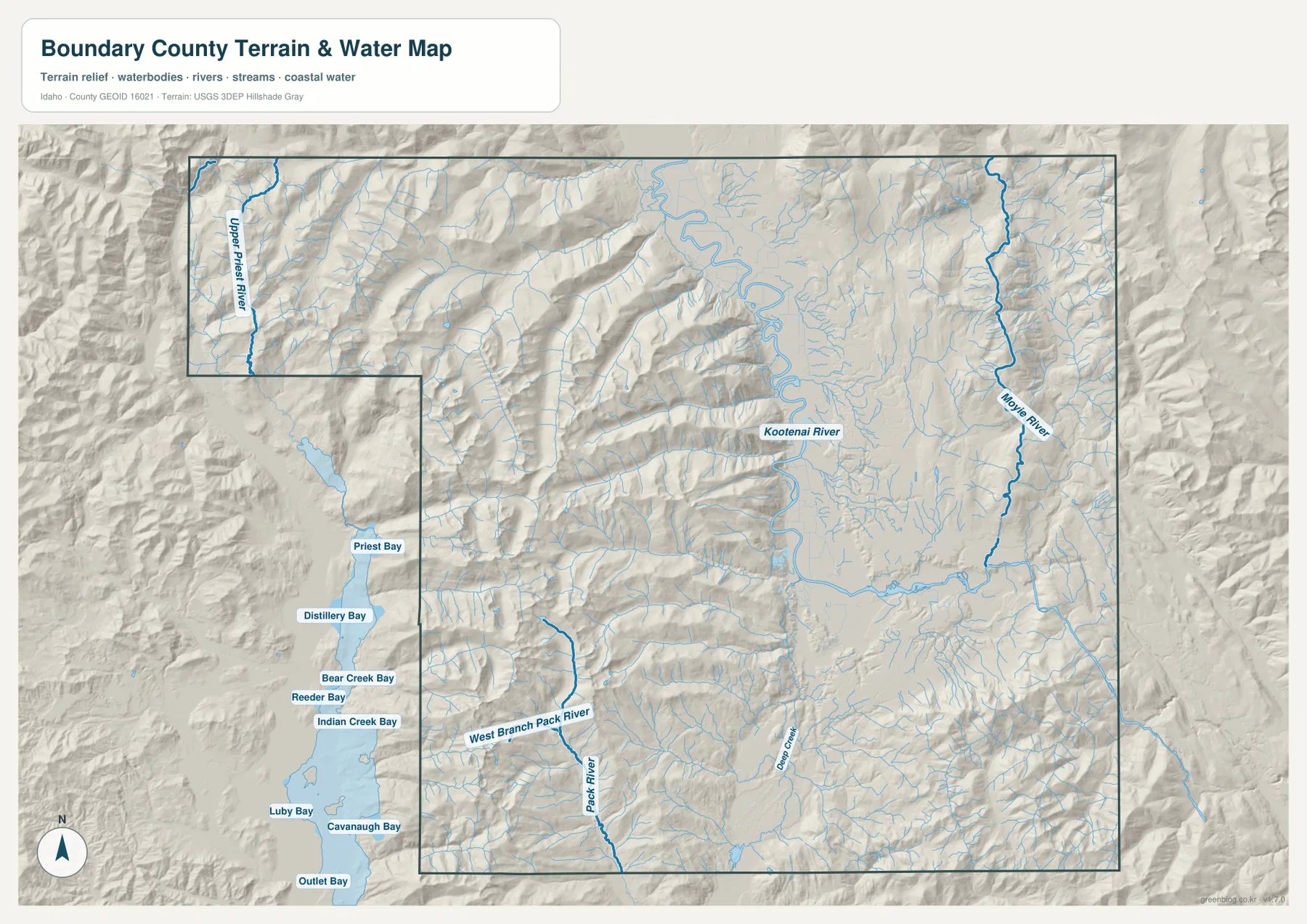
The Kootenai River is the dominant water feature on the terrain-and-water map. It enters from the east, bends through the Bonners Ferry area, and then meanders north through the broad valley. Boundary County’s comprehensive plan likewise identifies the Kootenai as the county’s most prominent water body and describes the lower valley north of Bonners Ferry as a major agricultural corridor.
The Moyie River descends through the eastern side of the county and joins the larger Kootenai system. The map also labels the Upper Priest River in the northwestern section and shows branches associated with Pack River and Deep Creek farther south. Numerous short tributaries spread across the mountain slopes, creating a much denser stream network than the broad main channel in the valley.
Some bays and water names visible near the western edge belong to adjacent areas and are included for geographic context. They should not be read as proof that every labeled feature lies inside Boundary County. This is a reference map for rivers, streams, terrain, and water locations, not a flood map, parcel map, depth chart, or navigation product.
The Kootenai valley sits far below the surrounding mountains
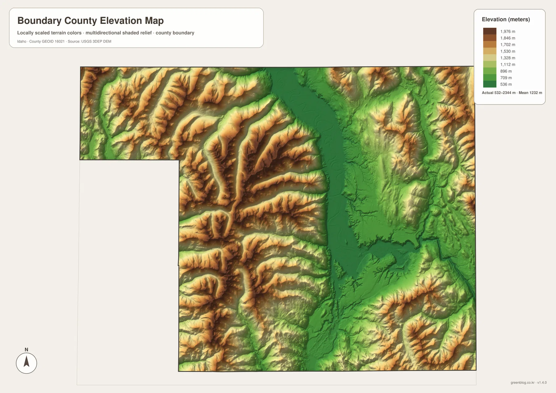
The elevation map makes the central valley stand out immediately. Deep green follows the Kootenai River north of Bonners Ferry, marking the broadest low area in the county. A second lower corridor follows the Moyie River, but the land rises rapidly on both sides into yellow, tan, and brown mountain ridges.
The supplied elevation map reports an actual range of about 532 to 2,344 meters, with a mean near 1,232 meters. The western mountains and the high eastern boundary are much higher than the river floor. These generalized values are appropriate for county-scale comparison, not for engineering design, construction staking, or survey-grade elevation at a specific property.
Compare settlements, water, and relief across the same places
For quick orientation, start with the city map to locate Bonners Ferry and Moyie Springs, then use the county overview to add roads and the northern border. The water map shows how both communities relate to the Kootenai and Moyie rivers, while the elevation map explains why the main valley looks so different from the mountain blocks on either side.
This sequence works well for classroom assignments, local research, presentations, and regional comparisons. A reader can follow one location through each view and see how settlement, transportation, waterways, and height are connected without needing specialized GIS software.
Frequently Asked Questions
What is the easiest place to use as a reference in Boundary County?
Bonners Ferry is the clearest reference point because it is shown in the main Kootenai River valley and near the county’s principal north-south road corridor. Moyie Springs is east of it and can be located quickly from there.
Where is Moyie Springs relative to Bonners Ferry?
Moyie Springs is east of Bonners Ferry, closer to the rising mountain terrain and the Moyie River corridor. The city map gives the simplest view of the relationship between the two places.
What is the main pattern on the elevation map?
The Kootenai River valley forms the lowest broad corridor, while mountain terrain rises sharply to the east and west. The map is best for comparing regional elevation, not for surveying a specific site.
Map File Information
The ZIP contains high-resolution A3 JPG versions of the Boundary County overview, city, terrain-and-water, and elevation maps.
- File Type: JPG files inside one ZIP archive
Related Maps
Sources and references
- Boundary County official website
- Boundary County Comprehensive Plan — water and community background
- Boundary County GIS
- U.S. Census Bureau TIGER/Line Shapefiles
- USGS National Hydrography
- USGS 3D Elevation Program
Green Map creates custom-edited map images using open geographic data sources such as geoBoundaries, Natural Earth, OpenStreetMap, and government open data.
These maps are edited visual materials, not raw data files, and are provided for education, documents, presentations, and graphic reference.