Northwest Hills Planning Region covers a broad, hilly section of northwestern Connecticut where towns are separated by river valleys, reservoirs, and winding roads. The supplied map set approaches that geography in three different ways. The first shows the planning-region boundary, settlements, and numbered roads; the second uses Torrington as a hub and connects it to Litchfield and Bantam; the third brings the Housatonic River, Barkhamsted Reservoir, smaller rivers, and shaded terrain to the foreground. High-resolution JPG versions of all three maps are available in the download box later on the page.
The U.S. Census Bureau treats Connecticut’s planning regions as county equivalents in current federal geography. The identity data supplied with this package identifies Northwest Hills Planning Region with state FIPS 09 and county-equivalent FIPS 160. Northwest Hills Council of Governments says the region is made up of twenty-one member municipalities: Barkhamsted, Burlington, Canaan, Colebrook, Cornwall, Goshen, Hartland, Harwinton, Kent, Litchfield, Morris, New Hartford, Norfolk, North Canaan, Roxbury, Salisbury, Sharon, Torrington, Warren, Washington, and Winchester. The maps do not label every member town, so the discussion below stays with places that are actually visible in the supplied images.
The outline is broad across the north and middle but develops a long, narrow southern extension below the New Preston area. Torrington is the clearest central reference on the road map. Canaan, Falls Village, Lakeville, Sharon, West Cornwall, and Cornwall Bridge occupy the western side near the Housatonic corridor, while Winsted and New Hartford Center anchor the northeast and east. Litchfield and Bantam sit southwest of Torrington. Those points give the region a very different shape from a compact metropolitan county.
Table of Contents
Torrington provides the simplest starting point for the road map
Torrington sits slightly east of the middle of the planning region and is surrounded by several of the map’s most useful road references. Route 4 crosses the area near the city, and U.S. 202 and other numbered routes help connect Torrington with Litchfield, Winsted, and communities farther east. Winsted appears to the north, while Litchfield and Bantam lie to the southwest. Starting with those four places makes the rest of the map much easier to follow than trying to read every road number at once.
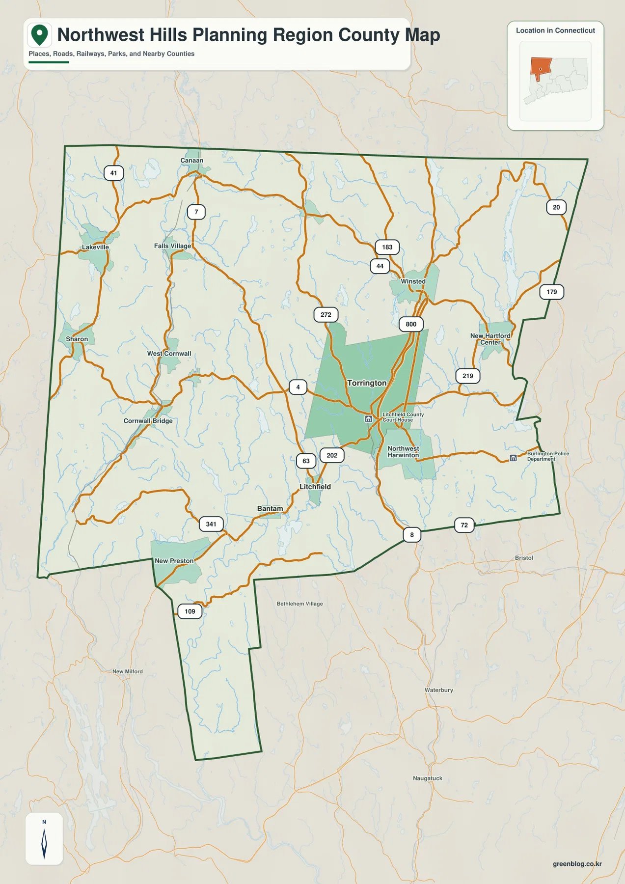
On the western side, U.S. 7 runs from the Canaan area south past Falls Village toward Cornwall Bridge, broadly following the same side of the region as the Housatonic River. Lakeville and Sharon sit close to the western boundary, and Route 41 gives another north-south reference in that section. The road pattern there is less centered on a single city and more closely tied to valleys and small town centers. For readers unfamiliar with the region, U.S. 7 and the Housatonic corridor are good anchors for locating the northwest and west.
Torrington’s surrounding routes include 4, 202, 63, and 272 on the supplied map. Near Winsted, Routes 44 and 183 stand out, while New Hartford Center lies farther east near roads labeled 219 and 179. Route 8 appears toward the southeastern side of the region, and Route 72 is visible near the lower eastern edge. These roads show how the region connects outward, but the map does not provide live traffic conditions, travel times, construction closures, or turn-by-turn driving guidance.
Litchfield is southwest of Torrington near U.S. 202 and Route 63. The Litchfield County Court House is labeled nearby and serves as a recognizable map reference. Bantam lies farther west along the same general corridor, and Route 341 appears beyond it. New Preston is lower on the map near the beginning of the long southern extension. Those labels make it possible to understand why the boundary continues well below the broader northern body of the planning region.
Farther north, Canaan and Winsted are separated by a wide interior full of small roads, streams, and lakes. The east around New Hartford Center has a clearer set of numbered-road labels, while the west often follows the bends of river valleys and hilly terrain. The general map is useful for comparing those differences, but it should not be treated as a parcel, zoning, ownership, or legal-boundary map. Local land records and municipal GIS sources are the proper tools for those questions.
The city-connections map measures Litchfield and Bantam from a Torrington hub
The city-connections map strips away much of the road-map detail and makes Torrington the hub. It connects Torrington with Litchfield and Bantam and labels the distances as 7 miles and 10 miles respectively. The legend explicitly describes these as direct distances, so they should be read as straight-line measurements rather than driving mileage. Actual road trips will usually be longer because roads bend through hills, intersections, and town centers.
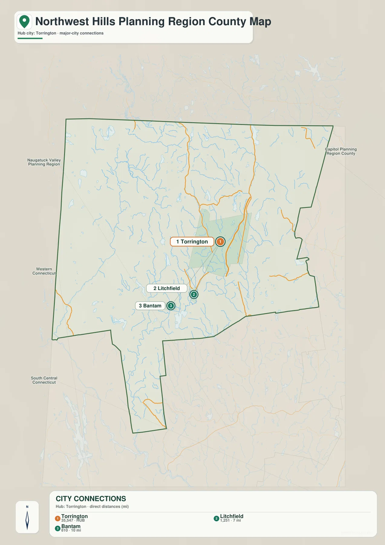
The three points form a simple southwestward sequence. Torrington is the northeastern point of the group, Litchfield lies southwest of it, and Bantam is slightly farther west and south. Returning to the detailed road map adds context: U.S. 202 and Route 63 help explain the road network around Litchfield, while the Bantam area sits closer to rivers and lake country shown on the terrain-and-water map. The straight connector lines are therefore best used for relative position, not as a suggested driving route.
This simplified map does not mean Torrington, Litchfield, and Bantam are the only places that matter in the planning region. The boundary map labels Canaan, Falls Village, Lakeville, Sharon, West Cornwall, Cornwall Bridge, Winsted, New Hartford Center, New Preston, and other reference points. The purpose of the city-connections layer is narrower: it gives one central hub and two nearby comparison points so the reader can understand local spacing without the visual clutter of every road and place label.
Neighboring planning regions are named outside the dark boundary, including Western Connecticut, Naugatuck Valley, South Central Connecticut, and the Capitol area. Those outside labels are useful for statewide orientation. They are not member municipalities of Northwest Hills Planning Region, and a nearby name printed beyond the outline should not be counted as part of the region. The dark boundary remains the key divider between the subject area and surrounding context.
The Housatonic corridor contrasts with Barkhamsted Reservoir and eastern tributaries
The terrain-and-water map changes the emphasis completely. The Housatonic River is the dominant western watercourse, running down the left side of the region through a strongly defined valley. The Blackberry River and Hollenbeck River are labeled in the northwestern section and meet the larger river system nearby. Shaded relief makes the surrounding hills visible, so the river does not appear as an isolated blue line; it is clearly part of a long valley bordered by higher ground.
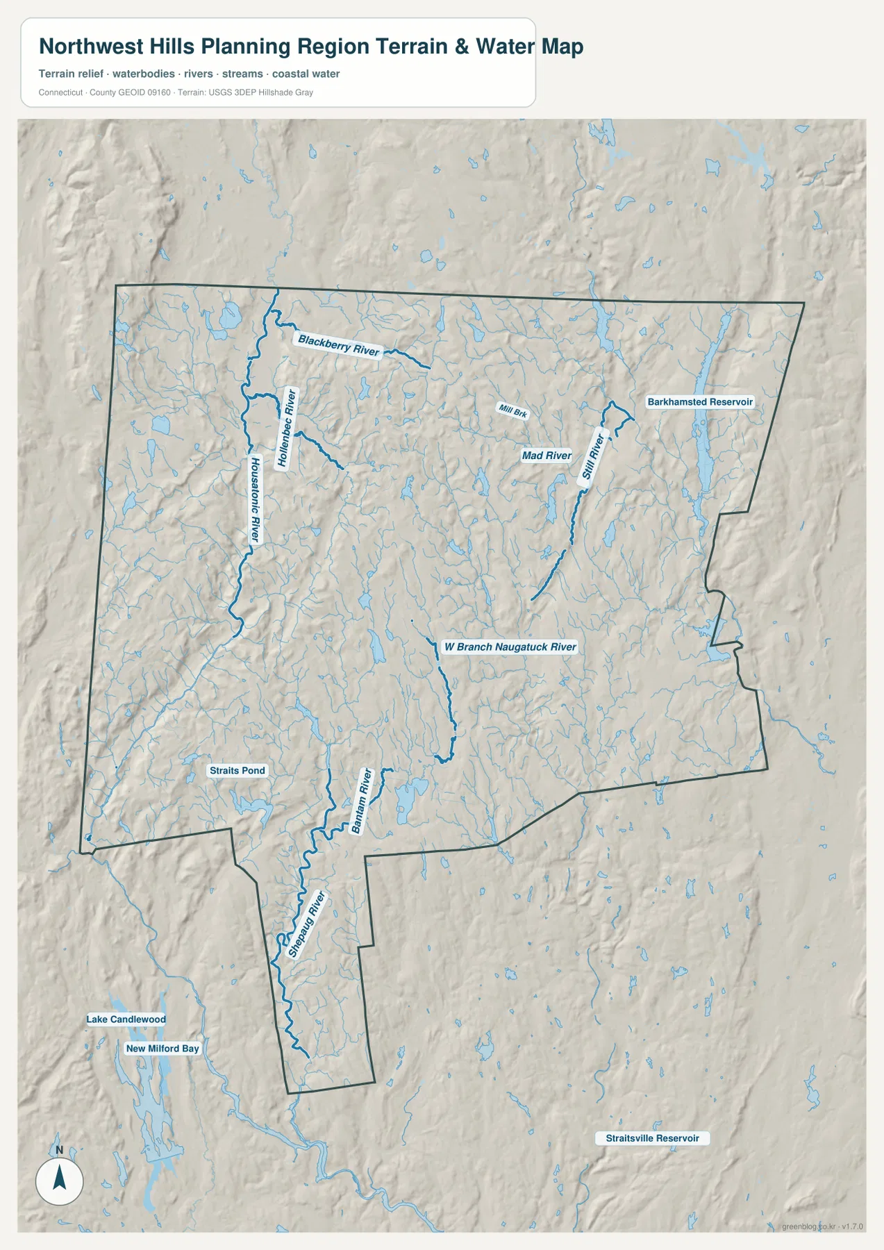
Barkhamsted Reservoir is the largest named water body on the northeastern side of the map. To its west, the Still River and Mad River are marked, with Mill Brook also labeled farther toward the center. This group of eastern waters is separate from the western Housatonic valley and helps show why the planning region cannot be summarized as a single watershed. Streams leave different parts of the highlands in different directions, and the road map becomes easier to understand once those valleys are visible.
Near the middle of the region, the West Branch Naugatuck River runs north-south and provides another major reference. Farther south and west, the Bantam River and Shepaug River become more prominent, and Straits Pond is labeled nearby. The narrow southern extension of the planning-region boundary follows an area where the Shepaug River is especially easy to see. If New Preston is located first on the road map, the water map then shows how that lower section fits into a broader network of streams and valleys.
Lake Candlewood and New Milford Bay appear beyond the boundary to the southwest, while Straitsville Reservoir is labeled outside the region to the southeast. They are helpful for orientation but should not be described as internal Northwest Hills water features simply because they are printed on the same image. The dark boundary line separates the planning region from its surroundings, and the article keeps that distinction when describing the map.
The shaded terrain also makes clear that the Northwest Hills are not a broad flat plain. Low ridges and river valleys repeat across the map, especially around the Housatonic and Shepaug systems. Shaded relief is useful for seeing broad landform differences, but it does not provide survey-grade elevation values. Exact heights, slopes, and engineering measurements should come from authoritative elevation products such as the USGS 3D Elevation Program.
The water layer is likewise a regional reference rather than a flood, navigation, water-depth, or legal-waterfront product. The blue lines and polygons show the general locations of rivers, streams, ponds, and reservoirs, but they do not establish flood probability, parcel boundaries, shoreline rights, or safe boating conditions. Flood-related decisions require current FEMA or state and local sources, and reservoir access rules should be checked with the appropriate managing agency.
A practical way to read the region from Canaan to New Preston
For a first look, locate Torrington and then place Winsted to the north, Canaan to the northwest, and Litchfield and Bantam to the southwest. Next, follow U.S. 7 down the western side and compare that road with the Housatonic River valley. Move east to New Hartford Center and Barkhamsted Reservoir, then return south to New Preston and the narrow extension of the boundary. That sequence turns an irregular outline into a set of understandable reference points.
Readers interested mainly in rivers can start with the Housatonic instead. Follow it south while identifying the Blackberry and Hollenbeck rivers, then shift toward the West Branch Naugatuck River in the center. Continue to the Bantam and Shepaug rivers and finish with the Still River and Barkhamsted Reservoir in the northeast. Once the main water features are familiar, switching back to the road map shows where Torrington, Winsted, Litchfield, and the smaller western communities sit relative to those valleys.
The high-resolution JPG files are more appropriate for printing and close inspection than the WebP previews embedded in the article. The package contains three originals—boundary and road, city connections, and terrain and water—and each is 2572 by 3638 pixels. That size preserves more detail when road numbers or small labels are enlarged, making the files useful for classroom handouts, presentations, or personal reference. For active navigation or emergency routing, use a current transportation source instead.
When comparing this page with older Connecticut maps, first check which boundary system the older source uses. Modern federal county-level datasets can use planning regions, while older documents may be organized around historic county names. Overlapping towns do not make the two systems identical. This page follows the Northwest Hills Planning Region boundary identified in the supplied package and in current Census county-equivalent geography.
Frequently Asked Questions
Why is Northwest Hills shown as a planning region instead of a traditional county?
Connecticut planning regions are used as county-equivalent geography in current U.S. Census Bureau products. The supplied identity data identifies Northwest Hills Planning Region as FIPS 09160. That lets it function as a county-level unit in modern federal statistics and mapping, even though it should not be confused with a traditional county government or with every historic county boundary shown on older Connecticut maps.
Are the 7-mile and 10-mile labels on the city map driving distances?
No. The map legend describes them as direct distances. Litchfield is shown 7 miles from the Torrington hub and Bantam 10 miles away in straight-line terms. Road mileage can be longer because actual routes follow hills, intersections, and existing road corridors. Use these figures to compare relative spacing, and use a current road or navigation source when planning a trip.
Can the terrain-and-water map be used for flood risk or exact elevation?
No. It is designed to show the general locations of the Housatonic River, Shepaug River, West Branch Naugatuck River, Barkhamsted Reservoir, and other mapped waters together with broad shaded terrain. Flood-risk decisions require current FEMA, state, or local flood mapping, and exact elevations should come from authoritative survey or USGS elevation data. Property and zoning boundaries also require municipal or state records.
Sources and reference material
- Northwest Hills Council of Governments – Who We Are: official regional organization and 21-member municipality list.
- U.S. Census Bureau TIGERweb – Connecticut Counties/Planning Regions: current county-equivalent identification for Northwest Hills Planning Region.
- U.S. Census Bureau TIGER/Line Shapefiles: boundary and geographic reference data.
- USGS National Hydrography: official river, stream, and water reference data.
- USGS 3D Elevation Program: authoritative elevation resources for more precise height data.
Map File Information
Download the Northwest Hills Planning Region boundary-and-road map, Torrington city-connections map, and terrain-and-water map as three high-resolution JPG files in one ZIP archive.
- Included Files: 3 maps
- File Type: JPG files in a ZIP archive
Related Maps
Green Map creates custom-edited map images using open geographic data sources such as geoBoundaries, Natural Earth, OpenStreetMap, and government open data.
These maps are edited visual materials, not raw data files, and are provided for education, documents, presentations, and graphic reference.