Kern County spans an unusually broad cross-section of inland California. Bakersfield and the southern San Joaquin Valley dominate the center-west, while the county reaches east through the Kern River mountains and Lake Isabella, southeast across the Tehachapi Mountains into Mojave Desert communities, and farther east to Ridgecrest near U.S. 395. Taft and Maricopa occupy a separate southwestern hill country. The result is a county where a flat agricultural valley, rugged river canyon, mountain passes, and high desert cities all appear on the same map.
Download the original high-resolution A3 JPG files from this Kern County Map page in one ZIP. The package contains a county reference map, a ranked city-distribution map, and a terrain-and-water map. There is no separate elevation map in the supplied package, so descriptions of higher and lower terrain stay with the visible relief shading and verified Kern County geographic information rather than adding an unsupported elevation layer.
Table of Contents
Bakersfield anchors the county government and the main valley road network
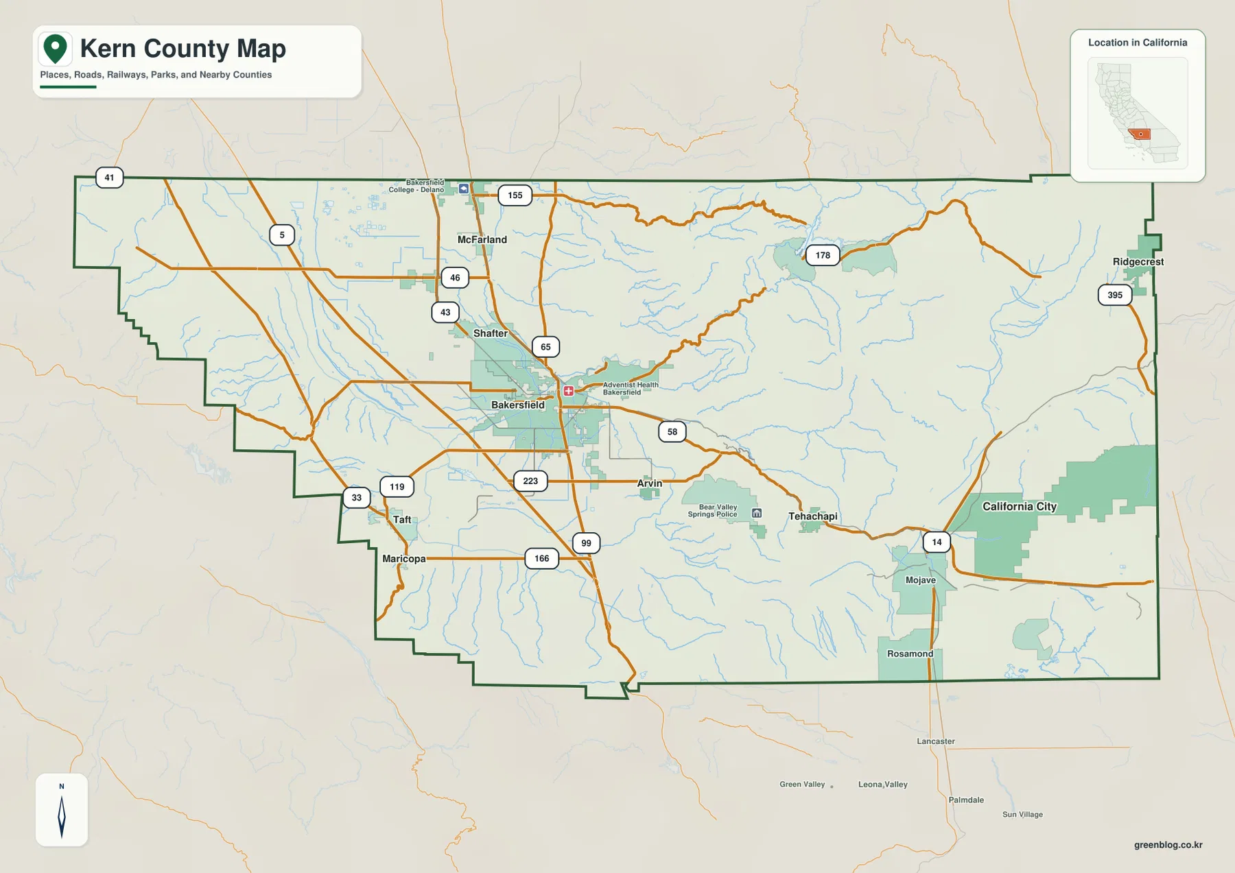
Bakersfield is the county seat. The Kern County District Attorney’s official site explicitly identifies Bakersfield as the county seat, and the reference map shows it as by far the largest developed area. Highway 99 runs north–south through the city, State Route 58 crosses the metropolitan area and heads east toward the mountains, and Interstate 5 passes through the broad valley farther west.
North of Bakersfield, the valley settlement pattern continues through Shafter and McFarland, with Delano farther north on the ranked city map. Highways 43, 46, and 99 divide the northern agricultural plain into several major corridors, while I-5 remains a separate long-distance route to the west. The roads are comparatively straight because this part of Kern County occupies broad low terrain rather than a narrow mountain passage.
East of Bakersfield, Lake Ming provides a smaller water landmark along the Kern River side of the metropolitan area. Continuing farther into the mountains brings the Lake Isabella region. To the southeast, Arvin lies close to the valley edge before Route 58 climbs toward Tehachapi. Using Bakersfield as a hub makes it easy to separate the county into a northern valley, eastern river mountains, southwestern hills, and southeastern desert.
Delano, McFarland, Wasco, and Shafter define the northern valley corridor
The northern part of Kern County remains largely within the San Joaquin Valley. Delano is the second-largest city on the supplied ranking, while McFarland and Shafter appear on the reference map and Wasco appears on the city map. All four lie in much flatter terrain than the eastern mountain communities.
Highway 99 provides the clearest line from Bakersfield toward McFarland and Delano. Shafter and Wasco are tied more closely to the Highway 43 and 46 corridors in the northwestern valley. Interstate 5 runs still farther west. The presence of several roughly parallel north–south routes shows how much travel space the broad valley provides compared with the narrow passes of the Tehachapi and Sierra sections.
The terrain-and-water map adds Lake Woollomes and the Kern River Canal as useful northern and northwestern water references. They are small compared with Lake Isabella, but they help distinguish the agricultural valley from the mountain watershed farther east. In this part of the county, canals and local water bodies sit in smoother terrain with fewer steep drainage lines.
Taft and Maricopa occupy a separate southwestern hill country
Taft and Maricopa lie southwest of Bakersfield and are easy to miss if the county is viewed only through its largest cities. State Route 33 runs through this part of the map, while Route 119 provides an important connection back toward the Bakersfield side. Relief becomes more pronounced as the map moves away from the central valley floor.
This southwestern corner is not the same landscape as either the Sierra around Lake Isabella or the Mojave Desert east of Tehachapi. It is a drier hill-and-valley region at the western and southern edge of the San Joaquin Valley. That difference is one reason a county-scale terrain map is useful: Kern County cannot be reduced to a single “valley” or “desert” description.
The county boundary also becomes irregular in this area, stepping around neighboring Los Angeles, San Luis Obispo, and Santa Barbara county territory. When checking whether a road or creek lies inside Kern County, the dark outer boundary is more reliable than a nearby place label alone.
Bakersfield dominates the ranked city map, with Delano a distant second
The supplied city-distribution graphic ranks six major cities. Bakersfield is shown at 411,986, followed by Delano at 51,679. Ridgecrest ranks third at 28,225, Wasco fourth at 26,558, Shafter fifth at 21,193, and Arvin sixth at 19,539. These are comparison values printed on the supplied image rather than the newest Census estimates, so current demographic work should use an official statistical source.
The locations reveal an important geographic split. Bakersfield, Delano, Wasco, Shafter, and Arvin are all in or near the San Joaquin Valley side of the county. Ridgecrest, however, sits far to the east in high desert country near U.S. 395. A population ranking therefore places together cities that belong to very different physical and transportation regions.
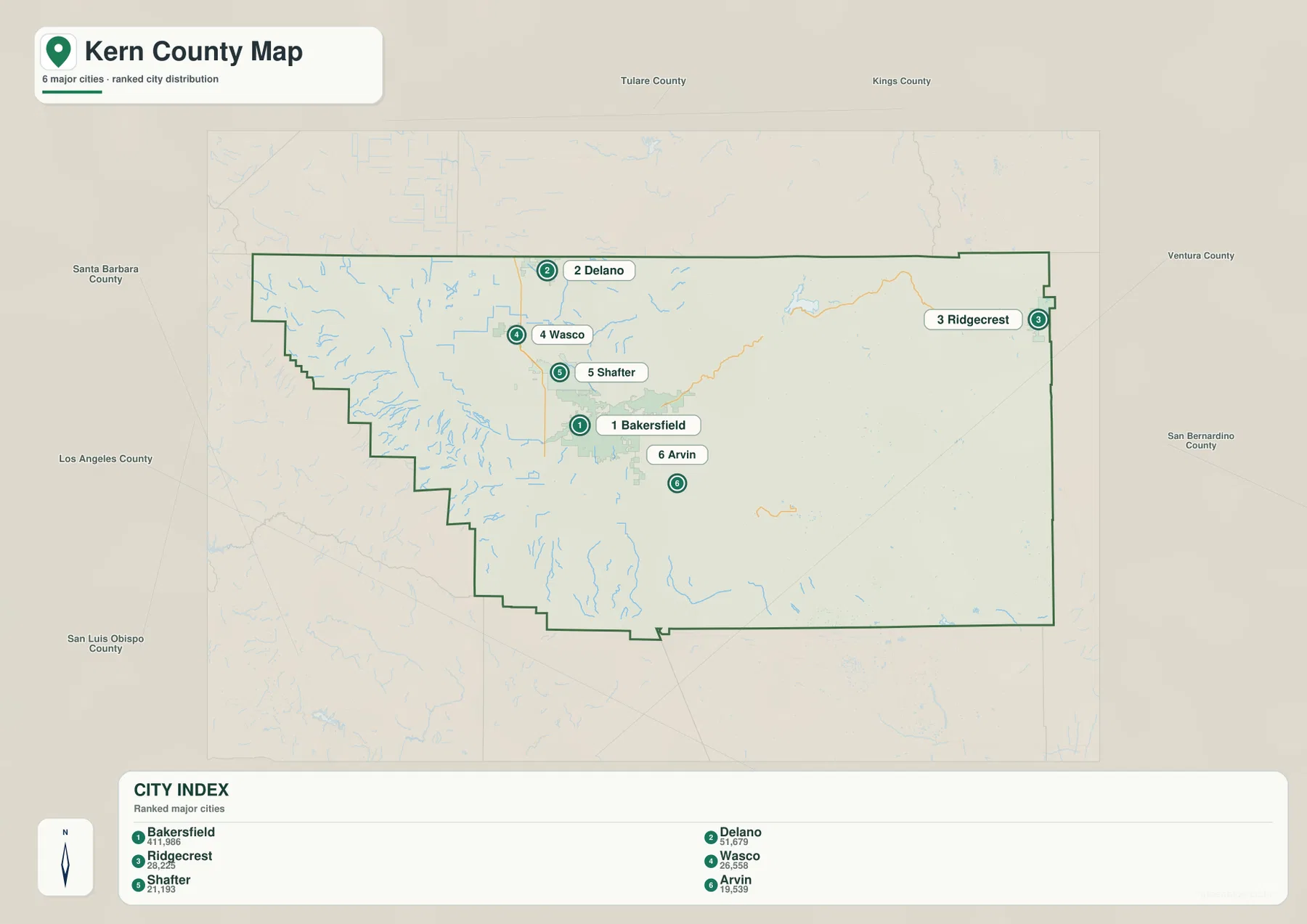
Kern County’s official incorporated-city list includes Arvin, Bakersfield, California City, Delano, Maricopa, McFarland, Ridgecrest, Shafter, Taft, Tehachapi, and Wasco. The ranked graphic shows only six of those places, so cities such as Tehachapi, California City, Taft, and McFarland remain important on the reference map even though they are not in the top-six panel.
The Kern River descends from the Sierra through Lake Isabella toward Bakersfield
The Kern River is the strongest natural water feature on the terrain map. It emerges through rugged Sierra terrain in the northeast, reaches Lake Isabella, and then continues west through a narrow mountain canyon toward the Bakersfield side of the county. The relief around the river becomes dramatically rougher east of the valley floor, with short tributaries cutting through closely spaced ridges.
Kern County’s official Lake Isabella page places the reservoir about an hour northeast of Bakersfield where Highways 178 and 155 meet. The county also explains that the U.S. Army Corps of Engineers built two earthen dams across branches of the Kern River in 1953 to create the reservoir. That makes Lake Isabella a particularly clear link between the road map and the water map.
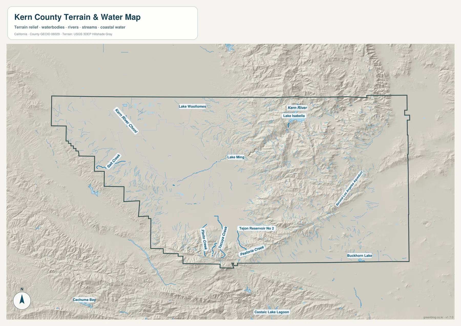
Lake Ming appears much closer to Bakersfield and is a useful smaller landmark along the Kern River corridor. Kern County Parks lists both Lake Isabella and Lake Ming among its official lake and boating facilities. Comparing the two shows the scale change between a major mountain reservoir and a much smaller recreational lake beside the metropolitan edge.
Route 58 crosses the Tehachapi Mountains and reaches the Mojave Desert cities
State Route 58 is one of the most revealing roads in Kern County because it connects very different landscapes. It leaves the Bakersfield valley area, climbs east through the Tehachapi Mountains, reaches Tehachapi, and then continues toward Mojave. The road bends with the mountain passage before emerging into a much broader desert setting.
The county’s official Parks and Recreation Master Plan describes Kern County as containing terrain and climate that range from desert to snow-capped mountains, with portions of the Central Valley, Mojave Desert, Sierra Nevada, and Coast Ranges. That description is visible along the Route 58 corridor itself: a reader can move from Bakersfield’s flat valley to Tehachapi’s mountain relief and then to the open desert around Mojave.
East of Tehachapi, Mojave becomes a major road reference. State Route 14 runs north–south through that area, California City occupies a broad developed footprint to the northeast, and Rosamond lies near the southern county boundary. The settlement pattern is far more spread out than in Bakersfield, and the terrain is dominated by open desert and low mountain blocks rather than dense river drainage.
Ridgecrest represents the far eastern high desert around U.S. 395
Ridgecrest is the third-largest city on the supplied ranking, but it is geographically isolated from the Bakersfield urban core. It lies near the far eastern edge of Kern County, where U.S. 395 provides the main north–south road reference. Large stretches of mountain and desert separate Ridgecrest from the central valley cities.
U.S. 395 continues toward Inyo County to the north and San Bernardino County to the south. This gives Ridgecrest a regional orientation that is different from Bakersfield, which is tied to Highway 99, I-5, and Route 58. The county map therefore contains more than one transportation system: valley freeways dominate the west, while desert highways become essential in the east.
The terrain-and-water map shows relatively few large natural water bodies in the southeastern desert, with small features such as Buckhorn Lake standing out against dry terrain. The Second Los Angeles Aqueduct is also labeled along the eastern and southeastern side. Its presence provides another visual contrast with the much wetter Kern River and Lake Isabella mountain system.
The flat San Joaquin Valley is sharply different from the Sierra and Tehachapi relief
There is no separate elevation map in this package, but the terrain shading clearly shows the county’s major physical divisions. Bakersfield and the northern valley cities occupy broad, smooth lowland terrain. Lake Isabella sits inside deeply cut Sierra mountains, while Tehachapi and the southeastern corridor cross another strong mountain belt before reaching the Mojave Desert.
Kern County’s official Parks and Recreation Master Plan places the county within the Central Valley and notes that its geography includes the Mojave Desert, Sierra Nevada, and Coast Ranges. This official description provides a useful framework for the supplied map. Precise elevation or slope work should use dedicated USGS elevation data; the relief image here is intended for regional comparison rather than measurement.
One useful three-point comparison is Bakersfield, Lake Isabella, and Mojave. Bakersfield represents the broad valley floor, Lake Isabella the rugged river-and-reservoir mountains, and Mojave the dry open desert beyond the Tehachapi passage. Seeing those places on both the reference and terrain maps makes the county’s geographic diversity much easier to understand.
Use Bakersfield as the hub, then separate the valley, river mountains, and desert
A practical first pass is to start at Bakersfield and follow Highway 99 north toward Shafter, McFarland, and Delano. Interstate 5 helps define the western side of the valley. For the southwest, Routes 119 and 33 lead toward Taft and Maricopa. For the southeast, Route 58 gives a direct line through Tehachapi to Mojave.
Next, switch to the water map and trace the Kern River from Lake Isabella toward Bakersfield. Ridgecrest can then be treated as a separate eastern reference along U.S. 395, while Mojave, California City, and Rosamond can be organized around Route 14. Dividing the county into valley, Kern River mountain country, and Mojave Desert keeps the map understandable without memorizing every road or minor stream.
Choose the file according to whether you need cities, roads, or the Kern River landscape
The county reference map is the best starting point for Bakersfield, Delano, Shafter, Arvin, Taft, Tehachapi, Mojave, Ridgecrest, highways, and the county boundary. The ranked city map is useful when the relative scale and position of the six largest mapped cities are the main questions. The terrain-and-water map provides the strongest view of the Kern River, Lake Isabella, Lake Ming, valley lowlands, Sierra relief, and the Tehachapi–Mojave transition.
For teaching or regional explanation, the reference and terrain maps work especially well together. Bakersfield can be shown at the center of the southern San Joaquin Valley, Lake Isabella can be connected with the Kern River and Highway 178, and Tehachapi–Mojave can illustrate the mountain-to-desert transition along Route 58. Ridgecrest then provides a clear far-eastern endpoint in a separate high-desert transportation region.
Each downloadable JPG measures 3638 × 2572 pixels and is suitable for A3 landscape printing, enlarging small place labels, or placing a map in a report or classroom handout. Keep the original aspect ratio when resizing so roads, rivers, and the county outline are not distorted. Printer margins vary, so checking one test page before a larger print run is useful.
Frequently Asked Questions
What is the county seat of Kern County?
Bakersfield is the county seat. Kern County’s District Attorney website explicitly identifies Bakersfield as the county seat, and the reference map shows it as the largest developed area at the center of the southern San Joaquin Valley road network.
How are Lake Isabella and the Kern River connected?
Lake Isabella is a reservoir on the Kern River system. Kern County states that two earthen dams were completed in 1953 to create the reservoir. On the terrain map, the Kern River leaves the Lake Isabella area and continues west through mountain terrain toward Bakersfield.
Does this download include a separate elevation map?
No. This Kern County package contains the county reference map, city-distribution map, and terrain-and-water map. Relief shading shows the major contrast between the San Joaquin Valley, Sierra and Tehachapi mountains, and Mojave Desert, but no separate numeric elevation map is included.
Map File Information
The ZIP contains the original Kern County reference, city-distribution, and terrain-and-water maps as high-resolution JPG files.
- Included Files: County reference map, city-distribution map, terrain-and-water map
- Printable Size: 3638 × 2572 pixels each
- File Type: Three high-resolution JPG files in one ZIP archive
Related Maps
Sources and References
- Kern County District Attorney – Criminal Division – Official county page identifying Bakersfield as the county seat.
- Kern County – Lake Isabella – Official information on the reservoir, Highways 178 and 155, the Kern River system, and dam history.
- Kern County Interactive GIS – Official county mapping and GIS resources.
- Kern County Parks and Recreation Master Plan – Official county context for the Central Valley, Mojave Desert, Sierra Nevada, Coast Ranges, and diverse terrain.
- USGS National Hydrography – Official U.S. river, stream, lake, and hydrographic data information.
Green Map creates custom-edited map images using open geographic data sources such as geoBoundaries, Natural Earth, OpenStreetMap, and government open data.
These maps are edited visual materials, not raw data files, and are provided for education, documents, presentations, and graphic reference.