Glenn County stretches from the broad Sacramento Valley on the east into the Coast Range on the west, creating a strong terrain contrast across northern California. Orland and Willows form the county’s two incorporated city centers along the Interstate 5 corridor. Hamilton City lies closer to the Sacramento River on the northeastern side, while Elk Creek sits far to the west in hill and mountain country. Roads are relatively straight across the valley but become much more winding around western creeks and reservoirs.
You can download the original high-resolution A3 JPG files from this Glenn County Map page in one ZIP. The package contains a county reference map, a ranked city-distribution map, and a terrain-and-water map. There is no separate elevation map in the supplied package, so higher and lower terrain are described only from the relief shading actually shown and from verified Glenn County geographic information.
Table of Contents
Orland and Willows form two distinct centers along Interstate 5
Glenn County has two incorporated cities, Orland and Willows. A current county profile identifies Willows as the county seat and Orland as the other incorporated city. On the reference map, Orland lies in the north-central valley and Willows is farther south, with Interstate 5 passing close to both. Their location shows how strongly the county’s main settlement pattern is concentrated on the flatter eastern side.
State Route 32 crosses the Orland area from west to east and continues toward Hamilton City and the Chico side of the Sacramento River corridor. State Route 162 provides a similar east–west reference through Willows and reaches toward Elk Creek and the western foothills. Interstate 5 provides the north–south framework, while Routes 32 and 162 help separate the two city areas and connect them with very different landscapes to the east and west.
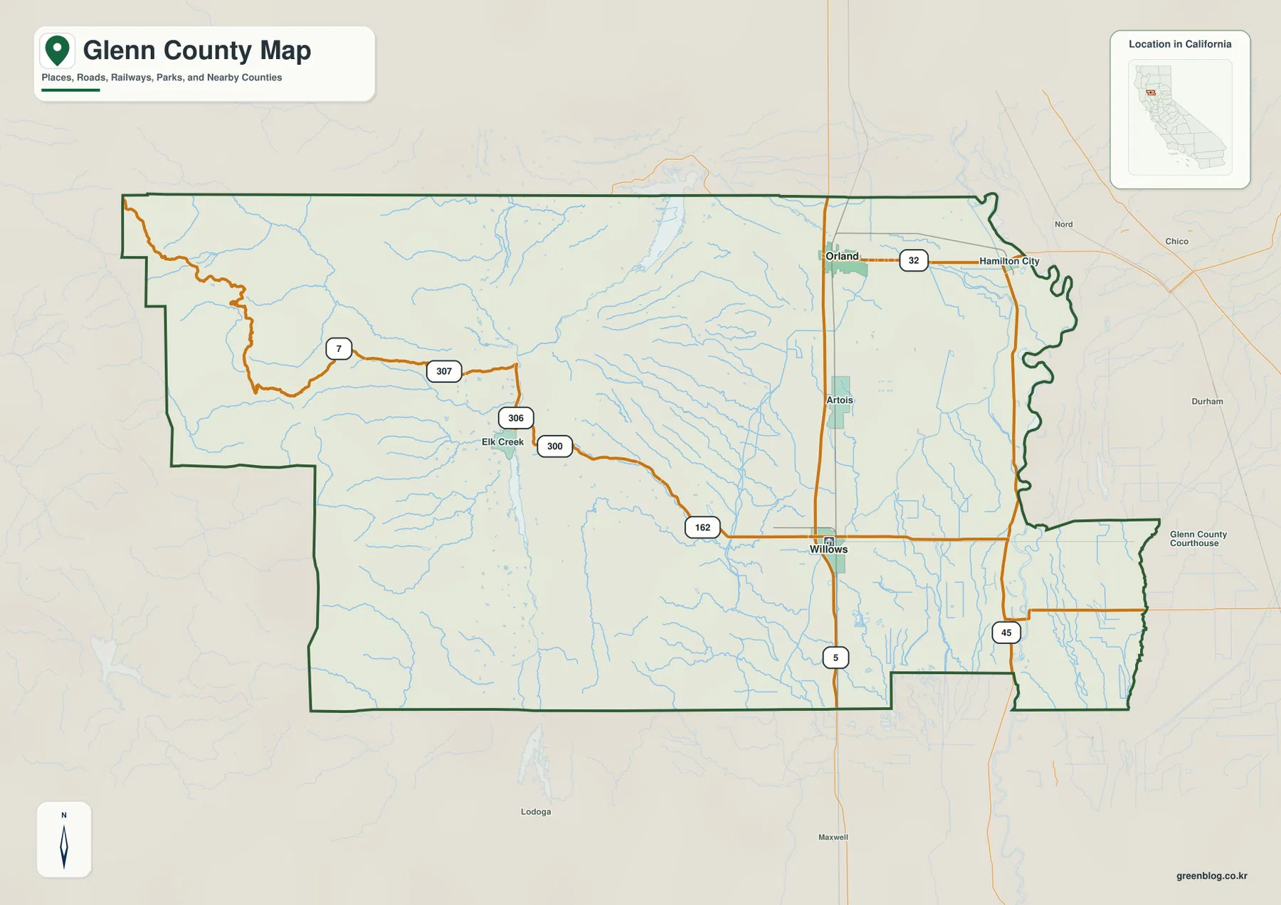
Artois appears between Orland and Willows, while Hamilton City sits east of Orland close to the Sacramento River. Elk Creek is separated from those valley communities by a broad area of foothills and mountain drainage. The map therefore changes quickly once it moves west of the I-5 corridor: settlement labels thin out, roads bend more often, and streams become more important for orientation.
Routes 32 and 162 show the transition from open valley roads to western mountain corridors
East of Orland, State Route 32 crosses relatively flat terrain toward Hamilton City. West of the main valley, the road network becomes more irregular. Around Elk Creek, Routes 300, 306, 307, and 7 follow a landscape with many more streams and ridges than the agricultural plain around Orland and Willows.
State Route 162 gives a second view of that same geographic shift from the Willows side. The route leaves the valley and heads west toward the Elk Creek and reservoir country. Glenn County hazard-planning material describes the eastern Sacramento Valley portion as nearly level terrain and the western side as Coast Range foothills and mountains. The reference map matches that difference clearly.
On the eastern side, State Route 45 follows a north–south course near the Sacramento River. It provides a useful reference for the valley communities and agricultural lowlands east of Interstate 5. In the west, roads alone become less useful, and water features such as Black Butte Lake, Stony Gorge Reservoir, and Grindstone Creek provide better geographic anchors.
The city map ranks Orland above Willows, even though Willows is the county seat
The supplied city-distribution graphic contains the county’s two incorporated cities. Orland is ranked first at 8,357 and Willows second at 6,190. These are comparison values printed on the supplied map rather than the newest Census estimates, so current demographic work should use an official statistical source.
The geographic pattern matters more than the ranking itself. Both cities occupy the Sacramento Valley side of the county and sit close to Interstate 5. Willows remains the county seat despite the larger value printed for Orland. The western two-thirds of the county appear almost empty on the ranked city view because there are no incorporated municipalities in that mountain area.
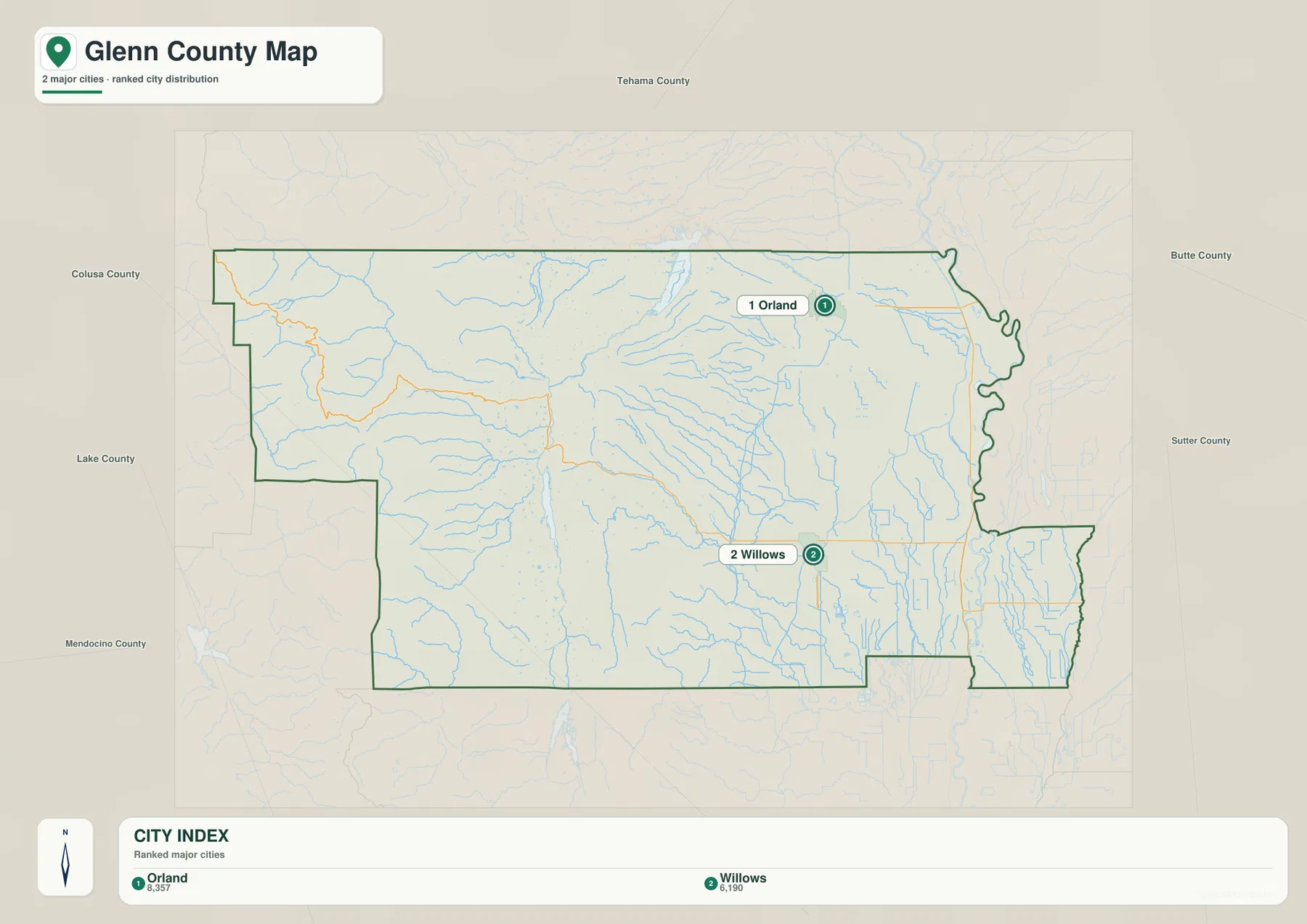
The broader reference map adds communities that the city graphic does not rank. A 2025–2026 Glenn County profile identifies Artois, Elk Creek, and Hamilton City as census-designated places in addition to the two incorporated cities. This makes the ranked image useful for municipal comparison, but the reference map is better for understanding the county’s actual settlement pattern and travel routes.
The Sacramento River creates a winding eastern edge beside a very flat valley
The Sacramento River is the strongest natural boundary reference on the eastern side of Glenn County. Current county background material describes the river as extending along the eastern boundary in a north–south direction. On the map, that side of the county bends repeatedly instead of following a straight line, especially near the Hamilton City and southeastern valley areas.
The terrain-and-water image also labels the Glenn-Colusa Canal and the Tehama-Colusa Canal across the eastern and central valley. Willow Creek and French Creek approach from the west, while smaller lowland channels spread across the agricultural plain. The contrast with western drainage is striking: valley waterways are surrounded by smooth terrain, while mountain creeks occupy narrow, shaded corridors.
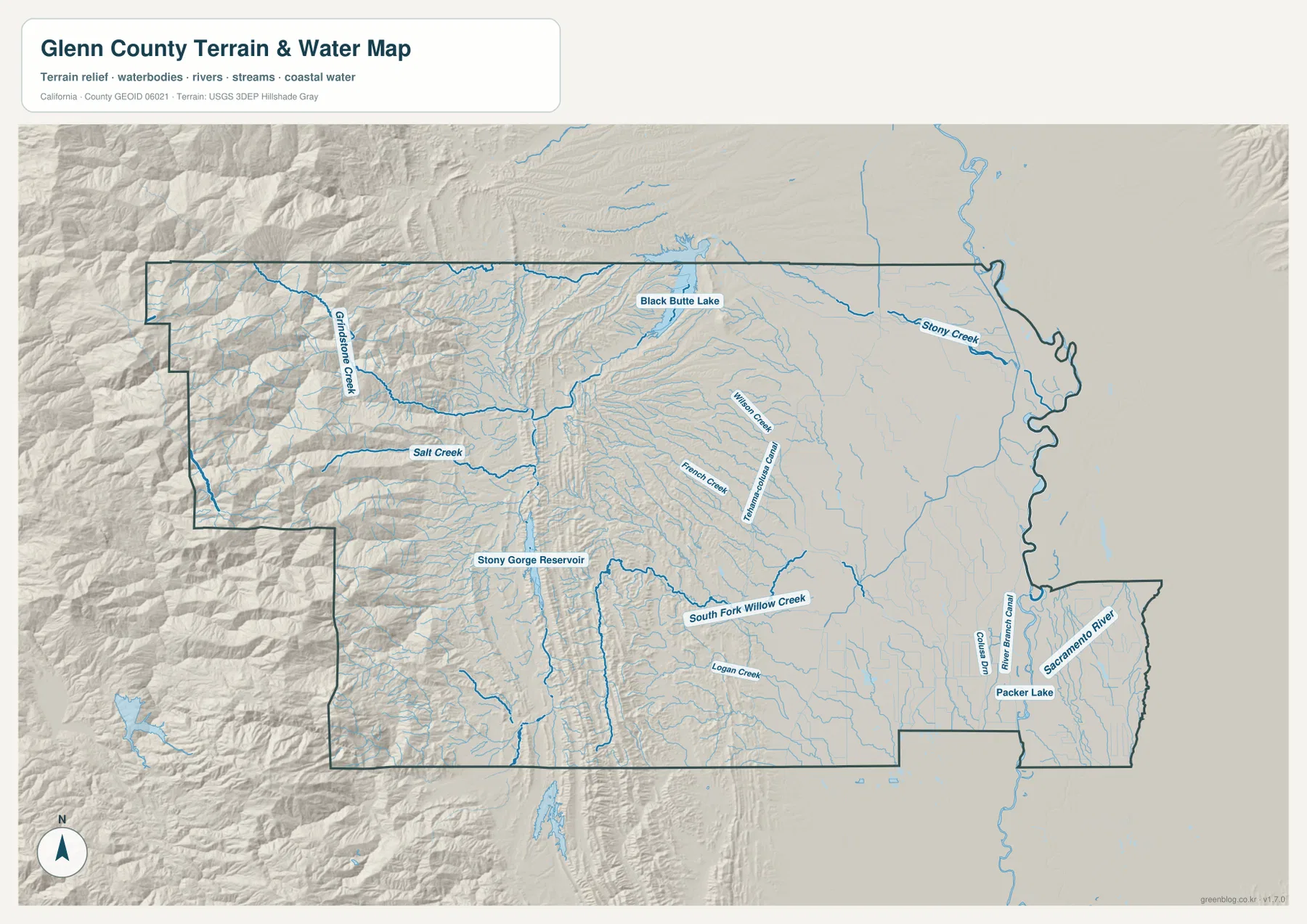
Packer Lake is labeled in the southeastern lowland, and a small block of Glenn County extends east of the Sacramento River in the lower-right part of the map. County hazard-planning documents describe a small southeastern area near Butte City that lies east of the river. The Sacramento River is therefore the main eastern boundary reference, but it does not place every acre of the county on the river’s west side.
Black Butte Lake marks the meeting of Stony Creek and the Sacramento Valley edge
Black Butte Lake is one of the clearest water landmarks in northern Glenn County. The U.S. Army Corps of Engineers places the lake on Stony Creek about eight miles west of Orland. Black Butte Dam created the reservoir, which sits near the transition between open valley country and the foothills to the west.
Stony Creek continues east from the reservoir toward the Sacramento Valley, while terrain becomes progressively rougher upstream to the west. On the supplied relief map, the area east of the lake is comparatively smooth, but ridges and tributaries become much more pronounced westward. That makes Black Butte Lake a practical landmark for understanding where the county begins to leave the valley floor.
This page treats Black Butte Lake as a geographic reference, not as a source of current reservoir conditions, flood information, or boating guidance. The U.S. Army Corps of Engineers maintains separate operational and recreation information, which should be checked for current conditions before a visit or water-related decision.
Stony Gorge Reservoir links the western mountains back to Black Butte Lake
Farther west, Stony Gorge Reservoir provides a second major water landmark. The U.S. Bureau of Reclamation places it about twenty miles west of Willows in western Glenn County and confirms that Stony Gorge Dam is on Stony Creek. Releases from the reservoir continue downstream for roughly twenty-two miles to Black Butte Dam and Lake, giving the two reservoirs a direct hydrologic connection.
Grindstone Creek and Salt Creek are labeled through the western mountain country, with South Fork Willow Creek and Logan Creek farther south. French Creek and Willow Creek descend toward the central valley side. These waterways follow narrow valleys between ridges, making the western half of the terrain map look far more dissected than the flat Sacramento River side.
In this part of the county, Elk Creek is a helpful place name but streams and reservoirs are often better orientation tools. Locating Stony Gorge Reservoir, then following Stony Creek east toward Black Butte Lake and Orland, creates a simple geographic sequence from Coast Range interior to valley edge.
The Coast Range drops sharply toward the Sacramento Valley
There is no separate elevation map in this package, but the terrain shading makes the west–east contrast unmistakable. Glenn County hazard-planning material describes the eastern third as part of the Sacramento Valley, with nearly level terraces, alluvial fans, floodplains, and basins. The western two-thirds are associated with Coast Range foothills and mountains, where relief becomes much stronger.
The reference map shows the same change through roads and settlement. Orland, Willows, Artois, and Hamilton City occupy broad open terrain with relatively straight routes. Around Elk Creek and farther west, road density drops, streams bend through narrow valleys, and relief shading becomes dominant. Precise elevations require dedicated USGS elevation data; the supplied terrain image is best used for broad geographic comparison.
Another useful piece of local context is Sacramento National Wildlife Refuge, which the U.S. Fish and Wildlife Service places about seven miles south of Willows and across Glenn and Colusa counties. The refuge is primarily wetland and grassland habitat. Its location helps explain the extensive lowland water and wetland environment on the eastern valley side even though the refuge boundary is not highlighted as a separate layer on this map.
Start with Orland and Willows, then follow the water westward
A first-time reader can begin with Interstate 5 and locate Orland and Willows. Artois fills the space between them. From Orland, State Route 32 leads east toward Hamilton City and the Sacramento River side. From Willows, State Route 162 points west toward Elk Creek and the reservoir country.
Next, switch to the water map and locate Black Butte Lake and Stony Creek. Continue west to Stony Gorge Reservoir and Grindstone Creek to see how quickly the terrain becomes more rugged. Returning east to the Sacramento River and the large canals makes the contrast with the agricultural valley especially clear.
Neighboring counties also help with orientation. Tehama County lies to the north, Butte County to the east, Colusa County to the south, and Mendocino and Lake counties to the west. Because much of the eastern boundary follows a winding river, the dark Glenn County outline is more reliable than nearby place labels when checking whether a feature lies inside the county.
Choose the map according to whether you need settlements, roads, or the Stony Creek watershed
The county reference map is the best starting point for Orland, Willows, Hamilton City, Elk Creek, highways, and the county boundary. The city-distribution map gives a clean comparison of the two incorporated cities. The terrain-and-water map is the strongest choice for Black Butte Lake, Stony Gorge Reservoir, Stony Creek, the Sacramento River, canals, and the strong Coast Range-to-valley transition.
For teaching or regional explanation, the reference and terrain maps work especially well together. Orland can be connected with Black Butte Lake and Stony Creek, while Willows provides a road reference for the western Stony Gorge direction. Hamilton City and the eastern boundary illustrate the opposite setting: a very flat Sacramento River landscape with large canals and agricultural lowlands.
Each downloadable JPG measures 3638 × 2572 pixels and is suitable for A3 landscape printing, enlarging small place labels, or placing a map in a report or classroom handout. Keep the original aspect ratio when resizing so roads, streams, and the county outline are not distorted. Printer margins vary, so checking one test page before a larger print run is useful.
Frequently Asked Questions
Is Orland or Willows the county seat of Glenn County?
Willows is the county seat. Orland has the larger value on the supplied city-distribution graphic, but county government is centered in Willows. Both cities sit close to Interstate 5 on the Sacramento Valley side of the county.
Are Black Butte Lake and Stony Gorge Reservoir connected?
Yes. Both are part of the Stony Creek system. The Bureau of Reclamation states that releases from Stony Gorge Reservoir travel downstream on Stony Creek to Black Butte Dam and Lake. The terrain map shows the reservoirs at different points between the western mountains and the valley edge.
Does this download include a separate elevation map?
No. This Glenn County package contains the county reference map, city-distribution map, and terrain-and-water map. Relief shading shows the contrast between the western Coast Range and eastern Sacramento Valley, but no separate numeric elevation map is included.
Map File Information
The ZIP contains the original Glenn County reference, city-distribution, and terrain-and-water maps as high-resolution JPG files.
- Included Files: County reference map, city-distribution map, terrain-and-water map
- Printable Size: 3638 × 2572 pixels each
- File Type: Three high-resolution JPG files in one ZIP archive
Related Maps
Sources and References
- Glenn County 2025–2026 Community Profile – Official county information on Willows as county seat, Orland and Willows as incorporated cities, and the main census-designated communities.
- Glenn County General Plan Resources – Official county planning and environmental resources covering Sacramento Valley and Coast Range geography.
- U.S. Army Corps of Engineers – Black Butte Lake – Official information on Black Butte Lake, Stony Creek, and the location west of Orland.
- U.S. Bureau of Reclamation – Stony Gorge Reservoir – Official information on Stony Gorge Reservoir in western Glenn County and its downstream connection to Black Butte Lake.
- U.S. Fish & Wildlife Service – Sacramento National Wildlife Refuge – Official information on the wetland refuge south of Willows in Glenn and Colusa counties.
Green Map creates custom-edited map images using open geographic data sources such as geoBoundaries, Natural Earth, OpenStreetMap, and government open data.
These maps are edited visual materials, not raw data files, and are provided for education, documents, presentations, and graphic reference.