Contra Costa County spans the northern East Bay from Richmond and San Pablo Bay on the west to Antioch, Oakley, Brentwood, and the Sacramento–San Joaquin Delta on the east. Martinez, the county seat, sits near the northern shoreline. Concord and Walnut Creek occupy the central interior, while Danville and San Ramon extend the main developed corridor south through inland valleys. The county changes from bayside cities to hills, broad valleys, and finally low Delta waterways, so a single urban description does not capture the whole map.
You can download the original high-resolution A3 JPG files from this Contra Costa County Map page in one ZIP. The package contains the county reference map, ranked city-distribution map, and terrain-and-water map. There is no separate elevation map in this package, so the discussion of hills and lowlands stays with the relief shading actually shown and with verified Contra Costa County geography.
Table of Contents
Martinez is the county seat, while Concord anchors the central interior
Contra Costa County’s official website identifies Martinez as the county seat. On the reference map, Martinez appears near the north-central shoreline, west of Pittsburg and north of Concord. It is not the county’s largest city, but its administrative role makes it a useful starting point for understanding the northern part of the county and the nearby bayside transportation corridor.
South of Martinez, Concord and Walnut Creek form two major inland reference points. Concord occupies a broad central developed area, while Walnut Creek sits farther south near Interstate 680. The map also labels a California State University East Bay location in the Concord area. Together, these cities mark the transition from the northern shoreline into the inland valleys.
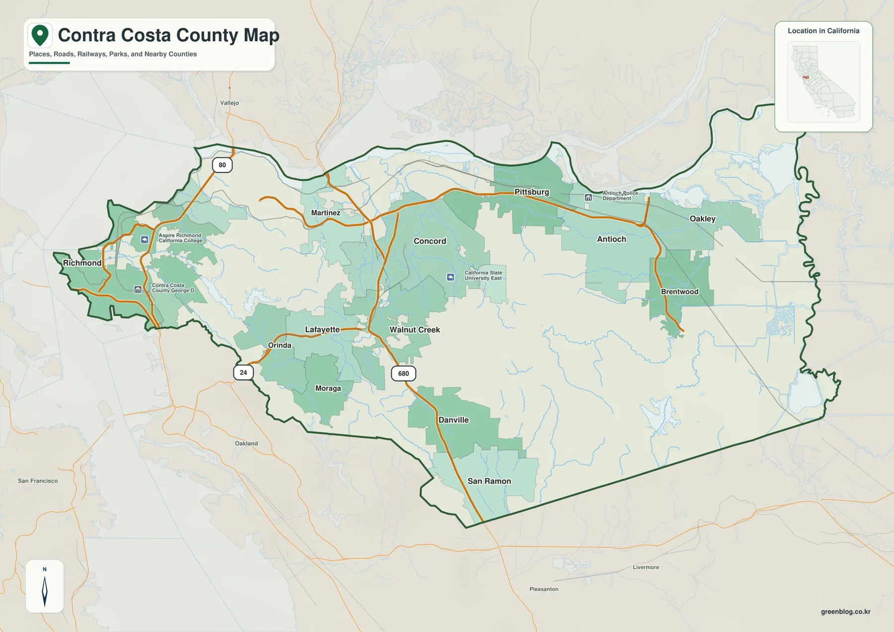
Interstate 680 continues south from the Walnut Creek area through Danville toward San Ramon. These communities form a long inland corridor between surrounding hills. West of Walnut Creek, Lafayette, Orinda, and Moraga occupy a more broken landscape near the Oakland and Berkeley hill system. The road pattern is tighter and more constrained there than in the broad eastern Delta side.
Richmond and the western communities sit close to the Bay and steep hills
Richmond occupies the far western side of the county near San Pablo Bay and the broader San Francisco Bay system. Interstate 80 is a major northern route through the area, connecting toward Vallejo and the Carquinez corridor. Moving inland from Richmond, the terrain quickly becomes hillier before reaching communities such as Orinda and Lafayette.
Highway 24 is one of the clearest east–west guides across this western hill belt. It approaches from Oakland, passes through Orinda and Lafayette, and reaches the Walnut Creek side. On the terrain map, ridges and narrow valleys surround much of that corridor, making it visually distinct from the flatter eastern county.
San Pablo Creek provides a useful water reference for the same western setting. It is labeled through the hills east of the bayside edge, with smaller tributaries joining from nearby slopes. The close spacing of shoreline, urban development, hills, and creeks gives western Contra Costa County a compact physical pattern that differs sharply from the Delta lowlands.
Concord, Antioch, and Richmond lead the ranked city distribution
The supplied city graphic ranks six major cities. Concord is shown first at 124,035, Antioch second at 116,477, and Richmond third at 115,505. San Ramon follows at 85,993, Pittsburg at 76,257, and Walnut Creek at 70,088. These figures are comparison values printed on the supplied image rather than a substitute for current Census estimates.
Their locations are more useful than the ranking alone. Richmond represents the western Bay side, Concord occupies the central interior, and Antioch is far to the east near the Delta. Pittsburg lies between Concord and Antioch along the northern shoreline corridor. Walnut Creek is south of Concord, while San Ramon is near the southern tip of the county.
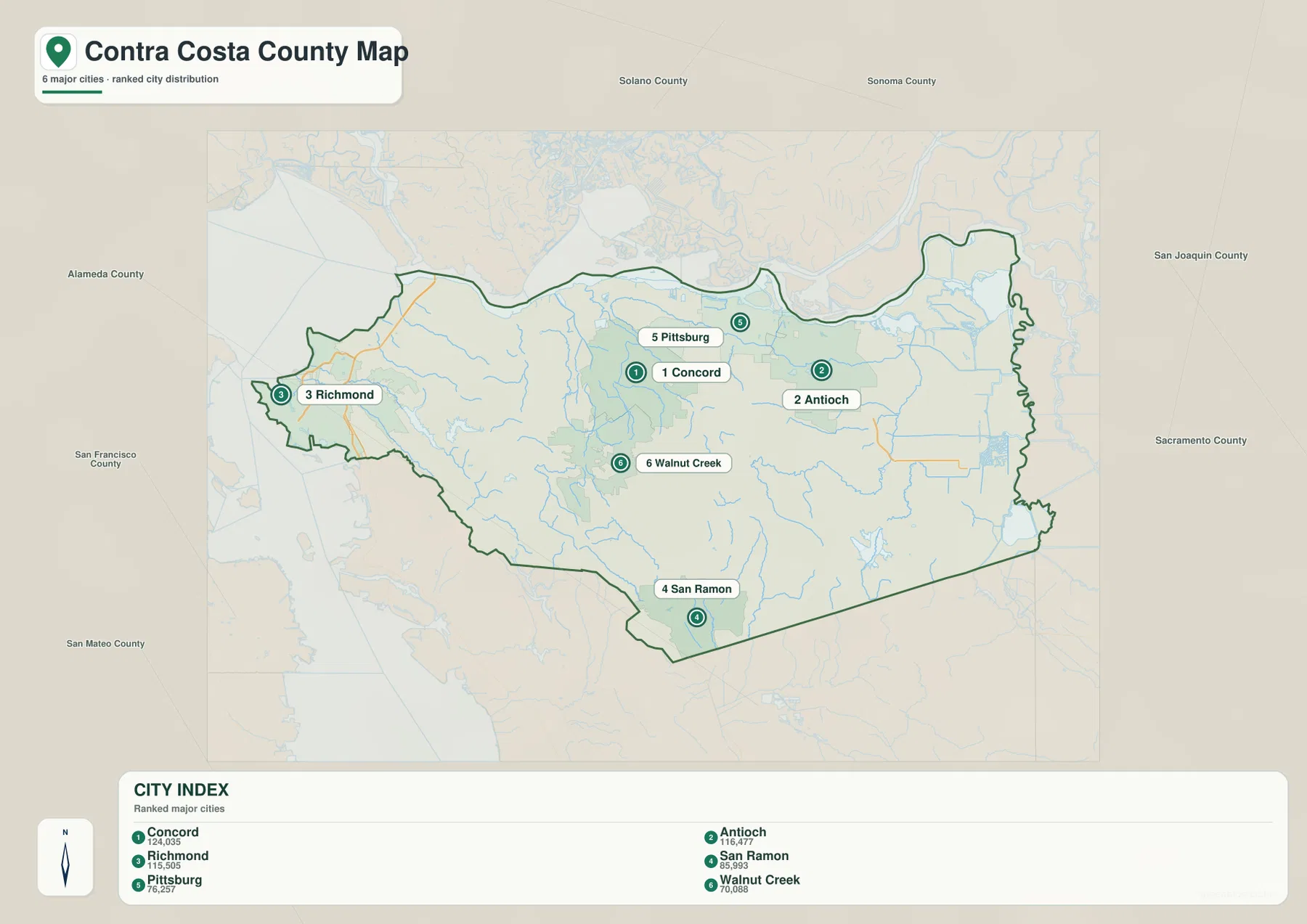
The city graphic does not include every important community. Martinez, Oakley, Brentwood, Danville, Lafayette, Orinda, and several other places remain important on the reference map. Use the ranked view for a quick comparison of major population centers and return to the county map when local roads, the county seat, and smaller cities matter.
San Pablo Bay and Suisun Bay lead east into the Delta water network
The terrain-and-water map makes the county’s long northern shoreline especially clear. San Pablo Bay occupies the northwest, while Suisun Bay extends east of the Martinez area. Farther east, Honker Bay and the Sacramento River are labeled before the map reaches the intricate channels of the Delta. Water forms a much larger part of the northern and eastern setting than the road map alone suggests.
Contra Costa County’s Emergency Operations Plan describes the physical geography as a mix of bayside plain, the Oakland and Berkeley hills in the west, inland valleys and Mt. Diablo in the center, and Delta waterways in the east. That description closely matches the supplied terrain map. Richmond and Martinez belong to the Bay side, central cities sit among hills and valleys, and Antioch–Oakley transition into flatter Delta country.
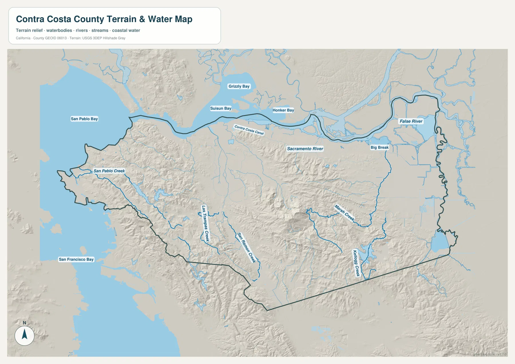
Big Break and False River are labeled near the eastern end of the map, where the county boundary bends around channels and low islands. The Contra Costa Canal also appears across the northeastern side. This is a very different landscape from Richmond’s bayside hills: Oakley and Brentwood sit beside broad, low terrain where natural and engineered waterways are both important.
Marsh Creek and the San Ramon drainage explain the central and southern valleys
In the inland county, smaller creeks become better geographic guides than the large bays. Contra Costa County’s Green Infrastructure Plan identifies Marsh Creek as the county’s longest major creek and lists the Walnut Creek watershed as including San Ramon, Pine, Grayson, and Las Trampas creeks. The supplied terrain map labels several of these streams in the central and southern interior.
Las Trampas Creek runs through the southwestern interior, while San Ramon Creek follows the lower valley near the Danville–San Ramon corridor. These waterways occupy lower paths between surrounding ridges, which helps explain why major roads and developed areas also extend through the same broad north–south valley. The roads and creeks are not identical routes, but the terrain influences both.
Marsh Creek crosses the central-eastern hill country toward the Brentwood side, and Kellogg Creek is labeled farther southeast. As the streams approach the eastern lowlands, relief becomes gentler and the drainage opens toward the Delta. The water map therefore provides a useful bridge between the central hills and the flat Antioch–Oakley–Brentwood side of the county.
Central hills and Mt. Diablo separate several major urban corridors
There is no separate elevation map in this package, but the terrain shading clearly shows that central Contra Costa County is not flat. The county’s official profile identifies Mt. Diablo, at 3,849 feet, as the landmark that dominates the county landscape. Broad hill country east of Concord and Walnut Creek separates the northern shoreline cities, southern inland valley communities, and eastern Delta settlements.
That terrain helps explain why Walnut Creek, Danville, and San Ramon form a long valley corridor rather than spreading evenly across the county. Lafayette and Orinda occupy another lower route through the western hills along Highway 24. Farther east, Antioch, Oakley, and Brentwood sit in a much more open and lower landscape close to Delta waterways.
The county’s Emergency Operations Plan also notes that much of the population is concentrated along the urban corridors of Highway 4 and 24 and Interstates 80 and 680. The reference map reflects that pattern, with dense development following those major transportation routes. Comparing the road map with relief shading makes the relationship between hills, valleys, and urban corridors much easier to understand.
Use two main corridors to organize the map before exploring the edges
One simple approach is to begin at Martinez and move east through Concord, Pittsburg, and Antioch. This establishes the northern part of the county, where cities sit close to the Bay and Delta shoreline. Continuing east reaches Oakley and the Delta water network, while Brentwood provides a southeastern reference point.
A second route begins around Walnut Creek and follows Interstate 680 south through Danville to San Ramon. San Ramon Creek and Las Trampas Creek help identify the lower interior valleys around that corridor. Highway 24 then provides a western connection from Walnut Creek through Lafayette and Orinda toward the Oakland side.
Richmond works well as a separate western anchor. It sits beside San Pablo Bay and near Interstate 80, clearly separated from the eastern Delta cities by hill country and the central interior. Thinking in terms of Richmond and the Bay, Martinez–Antioch along the north, Walnut Creek–San Ramon to the south, and Brentwood–Oakley in the east keeps the large county manageable.
Choose the file according to whether you need cities, roads, or Bay and Delta geography
The county reference map is the best starting point for Martinez, Richmond, Concord, Antioch, Walnut Creek, Brentwood, highways, and the county boundary. The ranked city map is useful when the main question is how the six largest mapped cities compare. The terrain-and-water image is the strongest choice for San Pablo Bay, Suisun Bay, Sacramento River, Big Break, central creeks, hill relief, and the eastern Delta.
For teaching or regional explanation, the reference and terrain maps work especially well together. Richmond and Martinez can be placed against the Bay shoreline, Concord and Walnut Creek can be shown among central hills and valleys, and Antioch–Oakley–Brentwood can be compared with the low Delta waterways. The same pair of maps also explains why road corridors change direction as they cross different terrain.
Each downloadable JPG measures 3638 × 2572 pixels and is suitable for A3 landscape printing, enlarging small place labels, or placing a map in a report or classroom handout. Keep the original aspect ratio when resizing so roads, waterways, and the county outline are not distorted. Printer margins vary, so checking one test page before a larger print run is useful.
Frequently Asked Questions
What is the county seat of Contra Costa County?
Martinez is the county seat. Contra Costa County’s official website identifies Martinez as the seat of government. On the reference map, it sits near the north-central shoreline, west of Pittsburg and north of Concord.
Why are there so many waterways in eastern Contra Costa County?
The eastern county reaches the Sacramento–San Joaquin Delta. The supplied water map shows the Sacramento River, Big Break, False River, and numerous channels around the Antioch–Oakley side, where the terrain is much lower and flatter than the central hills.
Does this download include a separate elevation map?
No. This Contra Costa County package contains the county reference map, city-distribution map, and terrain-and-water map. Relief shading shows the central hills and the lower Bay and Delta areas, but no separate numeric elevation map is included.
Map File Information
The ZIP contains the original Contra Costa County reference, city-distribution, and terrain-and-water maps as high-resolution JPG files.
- Included Files: County reference map, city-distribution map, terrain-and-water map
- Printable Size: 3638 × 2572 pixels each
- File Type: Three high-resolution JPG files in one ZIP archive
Related Maps
Sources and References
- Contra Costa County – Our County – Official background on Martinez as county seat, Mt. Diablo, and the county’s East Bay setting.
- Contra Costa County Emergency Operations Plan – Official geographic overview of the bayside plain, inland valleys, Mt. Diablo, and eastern Delta waterways.
- Contra Costa County Green Infrastructure Plan – Official watershed information for Marsh Creek, Walnut Creek, San Ramon Creek, and other major creeks.
- Contra Costa County GIS – Official county GIS maps and data services.
- USGS National Hydrography – Official U.S. river, stream, lake, and hydrographic data information.
Green Map creates custom-edited map images using open geographic data sources such as geoBoundaries, Natural Earth, OpenStreetMap, and government open data.
These maps are edited visual materials, not raw data files, and are provided for education, documents, presentations, and graphic reference.