Randolph County sits in northeastern Arkansas with Missouri directly along its northern edge. Pocahontas, the county seat, is the easiest reference point for understanding the area because several major highways meet nearby, while the Black River passes through the lower eastern part of the county. The maps on this page show roads, towns, rivers, lakes, and the strong elevation contrast between the ridged west and the flatter east. The same four maps are also available as original high-resolution A3 JPG files in one downloadable ZIP archive.
The county does not have one uniform landscape. Western Randolph County is broken into narrow ridges and valleys, and many small streams follow those lower cuts. Farther east, the land opens into broad low ground around the Black and Current rivers. Pocahontas lies close to the transition between those two settings, so comparing the road, water, and elevation maps makes the county much easier to understand than looking at place names alone.
Table of Contents
Pocahontas ties the road network together below the Missouri border
The general county map puts the Missouri border, Pocahontas, and the main road connections in one view. Highway 115 runs north through Maynard toward the state line, while U.S. 62 and U.S. 67 pass through the Pocahontas area and continue toward Biggers and Reyno in the east. Highway 90 heads south from Pocahontas, and U.S. 412 appears near the southwest side toward Imboden. This is not a turn-by-turn navigation map, but it is clear enough to show which communities sit along the major approaches to the county seat.
The county outline also helps with orientation. The northwestern boundary steps inward in several places, while the eastern side meets Greene and Clay counties before bending around river country farther south. Lawrence County lies to the southwest, and nearby places such as Imboden and Black Rock provide useful reference points outside the county line. With those surrounding names visible, Randolph County’s position near the northeastern corner of Arkansas becomes easy to recognize.
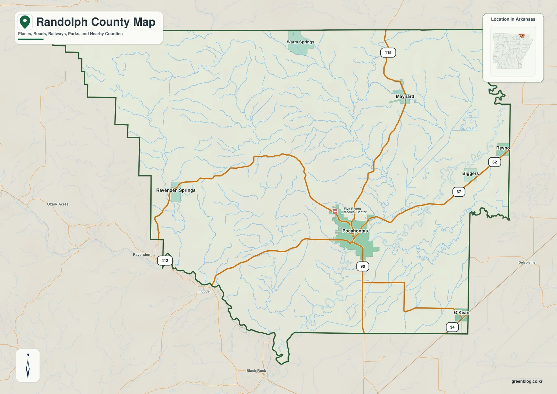
Use this map first when the main question is where a place sits within the county. Maynard is north of Pocahontas, Biggers and Reyno are much closer to the eastern boundary, O’Kean is southeast, and Ravenden Springs is separated from the eastern group by the hillier western half of the county. Once those positions are familiar, the water and elevation maps explain why the county changes so noticeably from one side to the other.
The six highlighted communities are spread across very different terrain
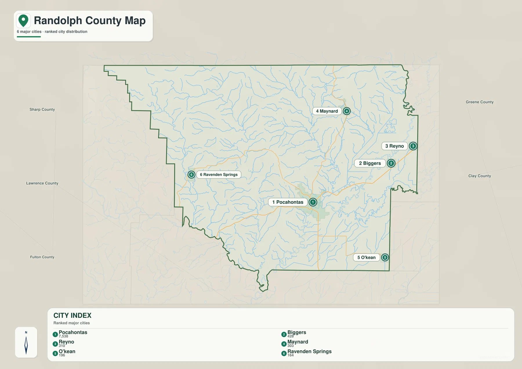
The city map highlights Pocahontas, Biggers, Reyno, Maynard, O’Kean, and Ravenden Springs. Pocahontas is the largest center in the group and sits near the southeastern half of the county rather than at its geometric center. Biggers and Reyno cluster toward the eastern side, Maynard stands farther north, O’Kean is near the southeast, and Ravenden Springs is isolated along the western side. Their distribution makes it clear that the county’s principal communities are not concentrated in one compact urban area.
Road placement reinforces that pattern. Several routes converge around Pocahontas, while the smaller eastern communities line up more closely with the U.S. 67 corridor and Maynard is associated with the Highway 115 route. Ravenden Springs occupies a very different setting in the western hill country. For a classroom map, report, or local overview, this simplified city view is useful because it removes some of the extra road detail and makes the relative positions of the six named communities easier to compare.
The elevation map adds an important second layer to the city distribution. Ravenden Springs lies in the rougher western terrain, where ridges and valleys are packed closely together. Biggers, Reyno, and O’Kean are in the lower and flatter eastern or southeastern part of the county. Pocahontas sits near the change between these settings, close to major roads and the Black River. Looking at the two maps together helps explain why communities that belong to the same county can occupy noticeably different landscapes.
Five major rivers meet a dense network of creeks and lowland water
The terrain-and-water map gives Randolph County a very different appearance from the road map. Five major rivers are labeled: the Black, Current, Eleven Point, Fourche, and Spring. The Current River bends through the eastern side, while the Eleven Point and Fourche cross the center of the county through lower valleys. The Spring River reaches the southwest boundary, and the Black River occupies the broad low country near Pocahontas and farther south.
Several smaller water features make the eastern lowlands especially distinctive. Suma Lake, Peachtree Lake, Gas Plant Lake, Schnabaum Lake, Wilson Lake, and Old River Slough are all labeled in or near the flatter eastern half. In the west, streams such as James Creek and Diles Creek run through much more broken ground. The contrast is easy to see: short branching streams dominate the ridge country, while larger rivers, sloughs, and lakes become more prominent toward the lower east.
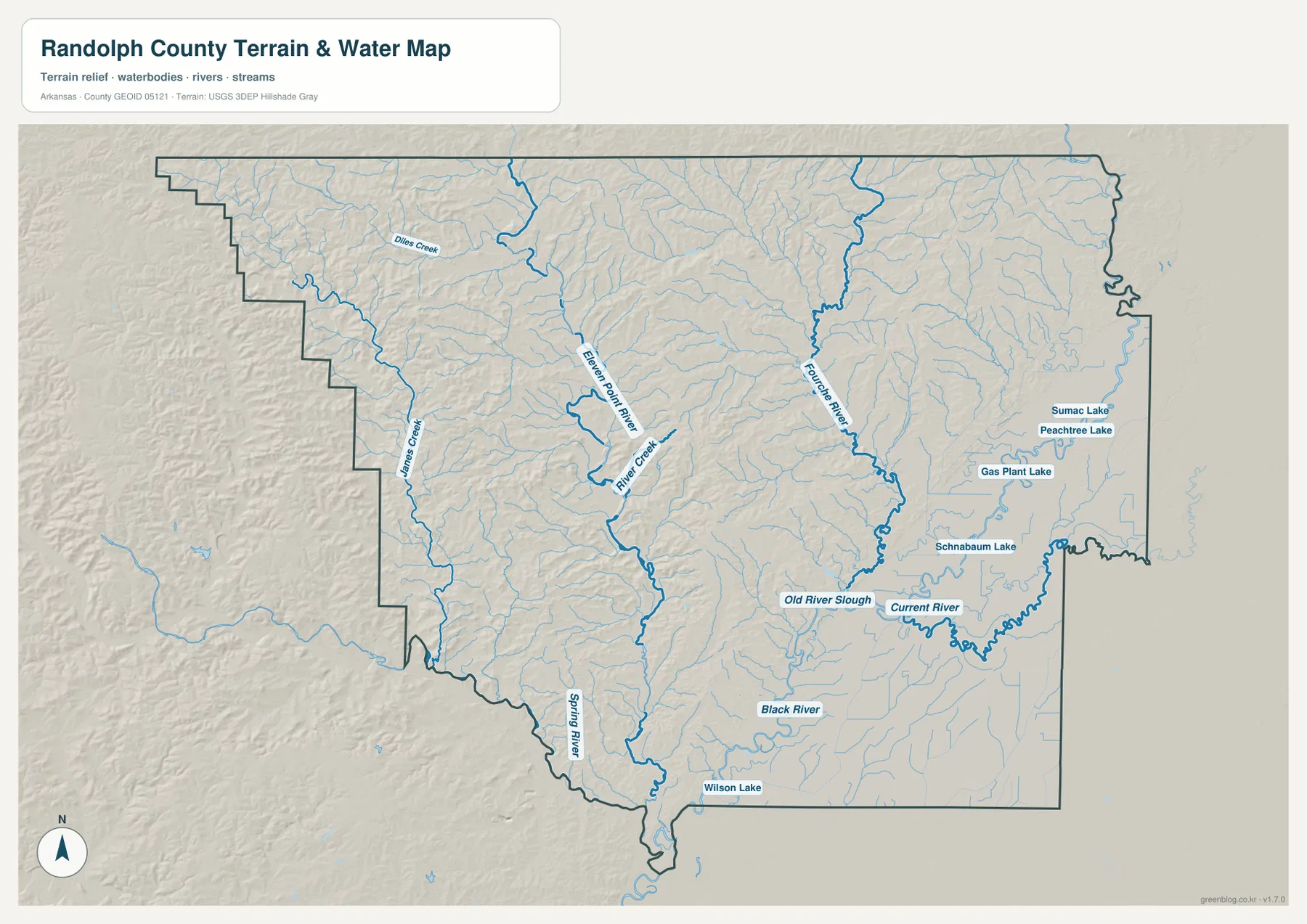
This map is designed for geographic reference, not for flood forecasting or navigation. It does not show current water levels, flood boundaries, channel depths, private property, or boating conditions. Those questions require current information from the appropriate agencies. Its value here is simpler: it shows where the major rivers lie, how smaller streams descend from the western hills, and why the eastern half of the county contains so much visible lowland water.
Western ridges drop sharply toward the Black and Current river lowlands
The elevation map shows the county’s east-west contrast more clearly than any other view. The underlying data span roughly 68 to 282 meters, with a mean near 120 meters. Brown and tan colors mark higher terrain in the northwest and west, where many narrow ridges and valleys appear. Moving east, the colors shift toward green as the land drops into the broad lowlands associated with the Black and Current rivers.
This is not a landscape dominated by one isolated mountain. Instead, the western half contains many smaller ridges separated by stream valleys. The Eleven Point and Fourche river corridors form lower routes through the middle of that terrain, and the surface becomes much smoother farther east. Comparing the elevation and water maps side by side shows why western tributaries follow narrow valleys before joining larger rivers on lower ground.
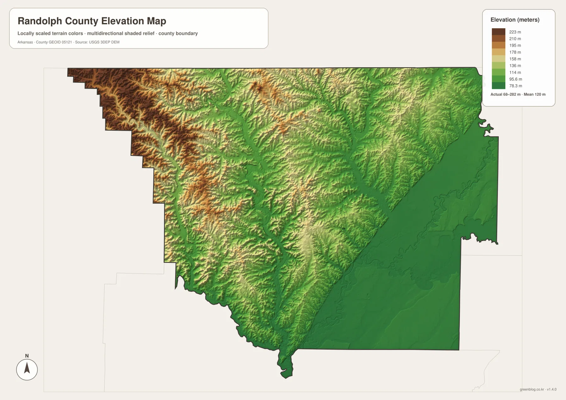
The elevation colors are intended for county-scale comparison. They should not be treated as survey-grade measurements for a building site, drainage project, property boundary, or engineering design. Precise work requires more detailed elevation data or a professional survey. For general reference, however, the map clearly explains why western Randolph County looks rugged while the eastern portion is flatter and closely tied to large river channels.
Choose the map that matches the question you are trying to answer
The general map is the best starting point for the county boundary, major roads, and the location of Pocahontas. The city map works better when the goal is to compare the six highlighted communities without as much visual clutter. A river-focused lesson or report should use the water map because it names the five major rivers and several smaller lakes and creeks. When the subject is the sharp change from western ridge country to eastern lowlands, the elevation map gives the clearest view.
For printing, use the original JPG files rather than the smaller page previews. Each original image measures 3638 × 2572 pixels and is prepared in an A3 landscape proportion. The files are suitable for classroom handouts, presentations, reports, and local reference sheets where labels need to remain readable at a larger size. Keep the original proportions when printing and check the printer’s margin settings first, since some devices may trim the outer edge.
River geography also helps explain the county’s early history
Roads dominate modern travel, but rivers played a much larger role in Randolph County’s earlier transportation and commerce. The Encyclopedia of Arkansas describes the Black, Current, Eleven Point, Fourche, and Spring rivers as important parts of the county’s history. Pocahontas developed near the Black River, so comparing the road and water maps provides useful context for how movement through the same landscape changed over time.
Davidsonville Historic State Park, south of Pocahontas, is another example of that connection. Arkansas State Parks explains that the historic settlement stood near the Black River and was associated with Arkansas’s first post office and one of its early courthouses. Davidsonville is not one of the six major communities highlighted on the city map, but its river setting helps explain why early government and commercial activity were established close to navigable water in this part of Arkansas.
Frequently Asked Questions
Which place is the best reference point for locating other communities in Randolph County?
Pocahontas is the most useful starting point. It is the county seat, several major roads meet nearby, and the Black River is close to the city. From there, Maynard lies to the north, Biggers and Reyno are to the east, O’Kean is southeast, and Ravenden Springs is far to the west.
Why is western Randolph County much rougher than the eastern side?
The west contains many closely spaced ridges and stream valleys, while the east opens into lower land around the Black and Current rivers. The elevation map shows this clearly, with higher brown and tan terrain in the west giving way to broad green lowlands in the east.
Can the water map be used for flood risk or boating decisions?
No. It is a geographic reference map showing rivers, creeks, lakes, and terrain. It does not provide current river stages, flood zones, channel depth, or boating conditions. Use current official water, weather, and navigation information for any safety-related decision.
What is the main city and county seat of Randolph County?
Pocahontas is the county seat and the largest center among the six communities highlighted on the city map. Several major roads pass through the area, and the Black River is nearby, making Pocahontas the easiest reference point for locating other places in the county.
Why does western Randolph County look so different from the east?
The western side contains closely spaced ridges and valleys along the Ozark foothill edge, while the east opens into lower and flatter land around the Black and Current rivers. The elevation map shows that change clearly as the higher brown and tan terrain gives way to broad green lowlands.
Can the water map be used as a flood or boating map?
No. It is a geographic reference showing rivers, tributaries, lakes, and terrain rather than current water levels or flood boundaries. Boating conditions, flood risk, and navigability change over time and should be checked with the appropriate official sources before making safety-related decisions.
Map File Information
The ZIP contains the original high-resolution A3 JPG versions of the Randolph County general, city, water, and elevation maps shown on this page.
- Included Files: General county, city, water, and elevation maps
- Printable Size: 3638 × 2572 pixels each
Related Maps
Sources and References
- Encyclopedia of Arkansas – Randolph County provides county history, Pocahontas context, and background on the major rivers.
- Arkansas State Parks – Davidsonville Historic State Park describes the early settlement and its location near the Black River.
- U.S. Census Bureau QuickFacts – Randolph County, Arkansas provides current county population and demographic information.
- USGS National Hydrography is an official source for U.S. river and stream data.
- USGS 3D Elevation Program provides national elevation data for terrain reference.
Green Map creates custom-edited map images using open geographic data sources such as geoBoundaries, Natural Earth, OpenStreetMap, and government open data.
These maps are edited visual materials, not raw data files, and are provided for education, documents, presentations, and graphic reference.