You can download the high-resolution JPG maps for Drew County from this page in a single ZIP after checking the online views. The county sits in southeastern Arkansas, with Monticello near the center of its road network, higher ground rising to the north, and broad lower terrain stretching toward Bayou Bartholomew on the east. The maps also show Wilmar, Winchester, Tillar, named creeks, and an elevation range of about 25 to 126 meters, so the page works as both a quick location reference and a printable map source.
Monticello is the easiest place to begin because it ties the road, town, water, and relief information together. Wilmar lies to the west, Winchester and Tillar sit near the eastern side, and several smaller communities appear toward the south and southeast. North of Monticello, the terrain rises into the most prominent ridge country in the county; farther east, the land drops into a flatter corridor crossed by the sweeping bends of Bayou Bartholomew. Looking from place names to creeks and then to elevation makes those changes easier to understand without crowding every detail onto one image.
Table of Contents
Start with Monticello to orient yourself in Drew County
Monticello is the county seat and the most prominent road center on the supplied county map. The Encyclopedia of Arkansas lists Drew County as having been established in 1846 and reports a 2020 Census area of about 828.66 square miles. On the map, Monticello sits slightly west of the county’s center, with several numbered routes radiating toward the surrounding communities. The University of Arkansas at Monticello is marked just south of the main built-up area, giving readers another familiar landmark when locating the city.
From Monticello, Wilmar lies a short distance to the west. Lacey is farther south, while Winchester appears near the northeastern edge and Tillar near the eastern side. Collins is southeast of Monticello and Jerome is marked close to the southeastern boundary. Nearby places outside the county, including Warren, McGehee, and Dermott, help show how Drew County fits into the broader southeastern Arkansas road network. This surrounding context is useful because the county is large enough that an address on the western side can feel quite separate from one near the eastern lowlands.
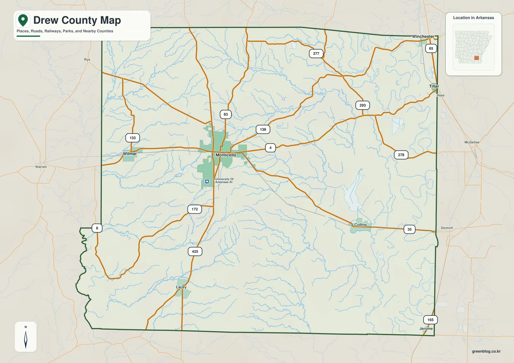
Route 4 crosses Monticello from west to east, and 425 continues south toward Lacey. The map also shows 83, 133, and 138 around the central and western portions of the county, with 277, 293, 278, and 35 serving parts of the northeast and southeast. U.S. 65 and 165 are visible along the far eastern side of the map near Tillar and Jerome. These lines are best used to understand relative position and regional connections. They are not a substitute for current navigation, construction notices, road closures, or detailed turn-by-turn directions.
North-central hills stand above the eastern lowlands
The elevation view immediately draws attention to the north-central part of the county. A band of brown and tan relief rises above the greener surrounding land, with short valleys cutting into both sides. The Encyclopedia of Arkansas identifies this upland as part of the Monticello Ridge, which extends from north of Star City through Drew County and continues south toward Louisiana. That description matches the strong ridge-like pattern visible on the supplied elevation map and helps explain why the county does not look uniformly flat even though it lies in southeastern Arkansas.
East of the ridge, the terrain becomes much lower and smoother. The eastern edge is especially green on the elevation image, and the large curves of Bayou Bartholomew are visible within that low corridor. The western and southwestern parts of Drew County are also lower than the north-central ridge, but they have a different appearance: broad low terrain is broken by creek valleys rather than by one dominant winding bayou. The result is a county with a clear high-ground core and several lower drainage directions around it.
This contrast matters when reading the road and water maps. Monticello occupies gentler ground near the southern end of the stronger ridge relief rather than sitting on the highest part. Wilmar is west of the higher band, while Tillar and the eastern communities lie closer to the lower Bayou Bartholomew side. Once that pattern is familiar, many of the creek locations become easier to understand because their valleys tend to descend away from the higher ground.
Wilmar, Winchester, and Tillar spread out from Monticello
The city-connections map uses Monticello as the hub and highlights Wilmar, Winchester, and Tillar as three additional reference points. It reports straight-line distances of about 9 miles from Monticello to Wilmar, 21 miles to Winchester, and 20 miles to Tillar. These are direct point-to-point distances, not driving mileage. A road trip can be longer because highways curve, cross waterways, or approach a community from a different direction.
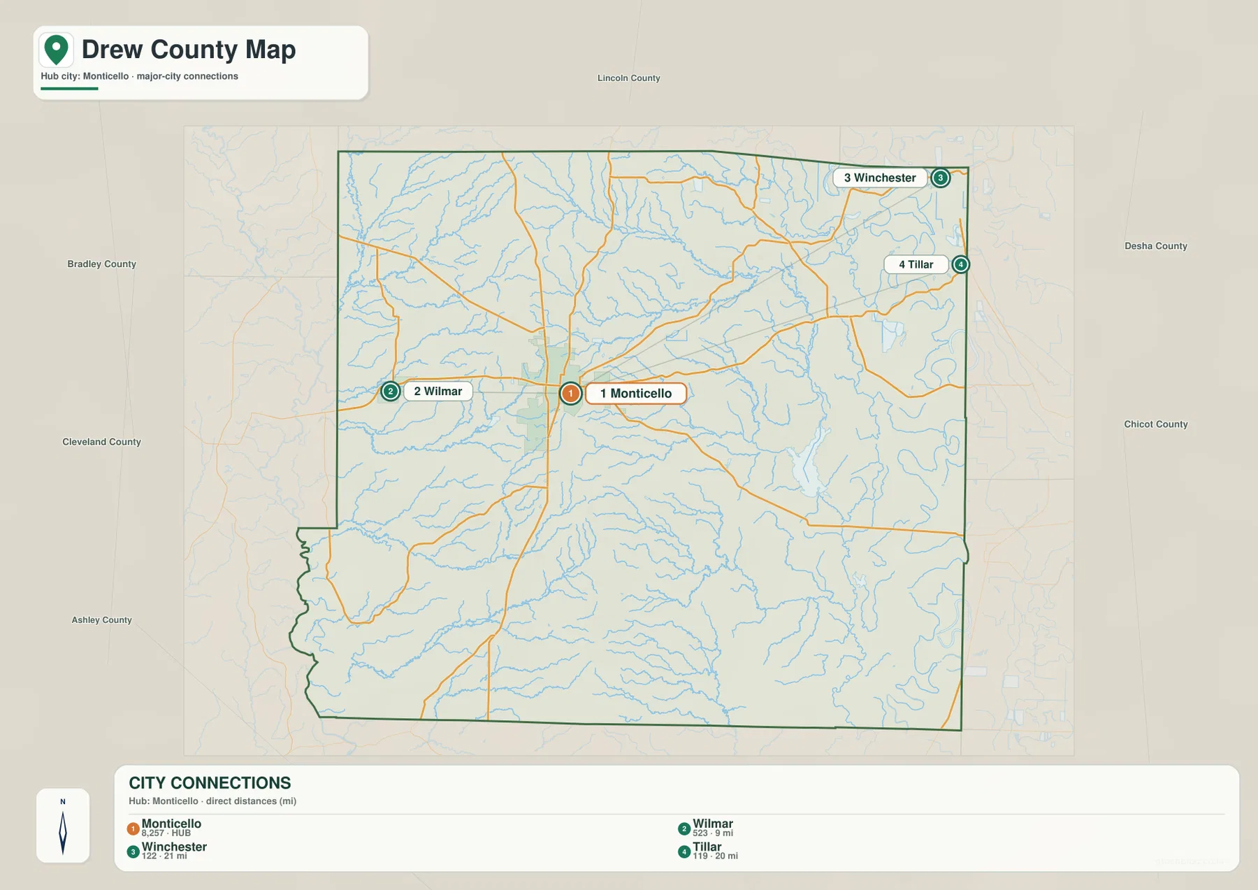
The map is especially useful for orientation because the three outlying places point in different directions. Wilmar is relatively close on the west side. Winchester is near the northeastern corner, while Tillar sits near the eastern boundary farther south. That spread makes it clear that Drew County is not a compact cluster of towns around Monticello. The labels for Lincoln, Desha, Chicot, Ashley, Cleveland, and Bradley counties outside the boundary also help users understand which neighboring county lies beyond each side.
After locating the towns on this simplified view, the main road map becomes easier to read. For example, Winchester and Tillar can be matched with the eastern highway corridor, while Wilmar can be traced back toward Monticello along the western routes. This two-step approach is often more useful than trying to absorb every road number and place label at once. The city map answers “where are the main reference points?” and the county map answers “how are they connected?”
Bayou Bartholomew anchors a dense network of smaller creeks
The terrain and water map reveals one of Drew County’s strongest geographic patterns: small streams are everywhere. Bayou Bartholomew winds along the eastern side in a broad lowland. Fountain Creek and Cut Off Creek occupy the eastern interior, while Upper Cut Off Creek, Lower Cut Off Creek, Panther Creek, and Prairie Creek appear farther north. Their shapes are more visible on this map than on the road map because road labels and town symbols no longer compete with the water features.
Other drainage runs toward the west and south. Ten Mile Creek crosses the western middle of the county, Clear Creek follows part of the southwest, and Brown Creek extends across the southern interior. Wolf Creek and Bearhouse Creek are visible in the southeast, with Sandy Creek nearer the center. Seven Devils Lake provides a useful point feature in the eastern interior. Taken together, these names show that Drew County is divided into many small valleys rather than drained by one simple channel running across the entire county.
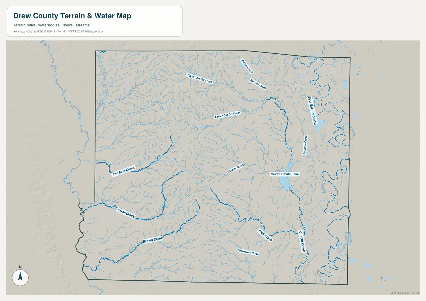
The Encyclopedia of Arkansas notes that Bayou Bartholomew runs along the eastern edge of Drew County and that the Saline River forms the southwestern border. Those two features help explain why some parts of the county outline follow irregular natural curves instead of straight survey lines. This image is intended for geographic reference, not flood-zone determination, navigation, water-quality assessment, or legal boundary work. For those purposes, use the latest specialized data from the responsible agency.
A 25–126 meter range creates a clear relief contrast
The elevation map reports an actual county range of roughly 25 to 126 meters, with a mean near 55 meters. The highest colors are concentrated in the north-central ridge country, where narrow valleys cut into a series of steeper slopes. The lower greens dominate the eastern Bayou Bartholomew corridor and also cover broad portions of the west and southwest. Even without mountains, a difference of around 100 meters across the county is enough to produce a very noticeable terrain pattern.
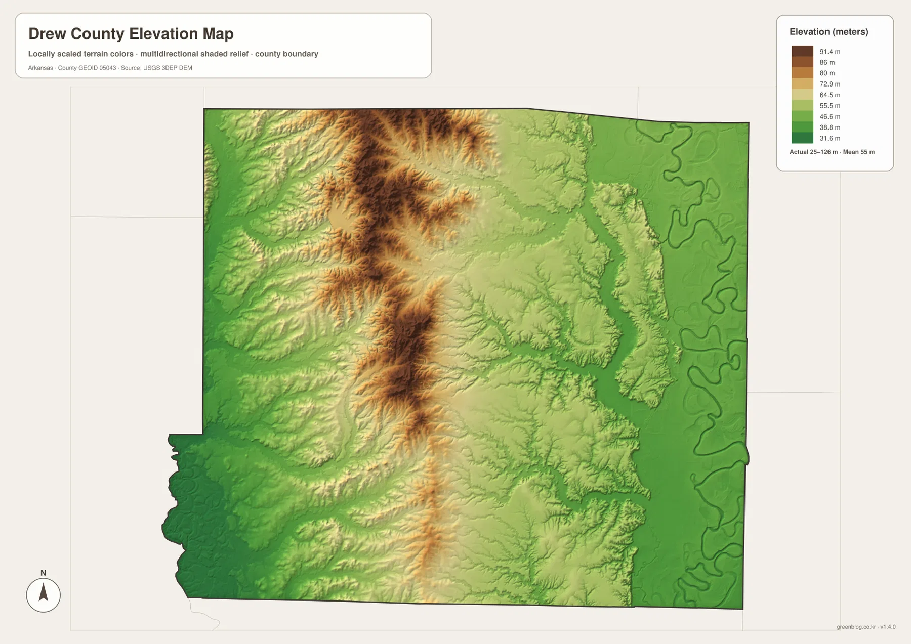
The eastern side is a good place to compare elevation and water directly. The broad low corridor on the elevation map lines up with the winding bayou and nearby channels on the water map. North and west of Monticello, the relationship is reversed: higher ridges separate small creek valleys that branch away in several directions. South of the strongest ridge, the terrain gradually breaks into lower rolling ground rather than dropping in one abrupt step.
This shaded surface is appropriate for county-wide comparison, not for surveying a building site or designing drainage. It compresses a large elevation dataset into a readable image, so an exact spot elevation should be checked against original USGS 3D Elevation Program data or a professional survey when precision matters. For classroom use, regional planning at a general level, travel context, or a printed county reference, the map makes the broad relief much easier to see than a table of elevation values would.
Compare the ridge with the creek valleys on both sides
One useful way to explore Drew County is to begin north of Monticello on the elevation map and then trace the valleys outward. On the eastern side of the high ground, Lower Cut Off Creek and Fountain Creek occupy progressively lower terrain before reaching the Bayou Bartholomew side of the county. To the west, Ten Mile Creek follows another low corridor. Farther south, Clear Creek and Brown Creek cross broad green areas that contrast with the steeper ridge texture to the north.
This explains why the water map contains so many named creeks even though the county map does not show a large central river. The ridge and rolling uplands divide runoff into several directions. Small valleys then combine as they approach larger lowland systems along the borders. The pattern also gives context to the irregular southwestern boundary, where the Encyclopedia of Arkansas identifies the Saline River, and to the looping eastern edge shaped by Bayou Bartholomew.
Monticello sits in a useful transition zone for seeing this change. The strongest high relief is north of town, but the road network and urban area occupy gentler terrain. Moving east from Monticello takes the viewer toward lower ground and increasingly winding water features. Moving west crosses low creek valleys toward Wilmar and the western boundary. That transition gives the county a more varied physical character than a quick glance at a standard political map might suggest.
Match the map view to the information you need
For a place-name search, begin with Monticello and the main road map, then follow the numbered routes toward Wilmar, Tillar, Winchester, or Collins. When road numbers are not important, the simpler city view makes the direction and straight-line distance from Monticello easier to compare. Named creeks, Seven Devils Lake, and the broad curves of Bayou Bartholomew are much clearer on the terrain-and-water image, where fewer road labels compete for attention.
When height is the main question, the elevation image immediately separates the brown north-central ridge from the greener eastern and southwestern lowlands. Comparing that image with the creek map helps explain why so many channels occupy the lower ground around the ridge. A traveler looking for communities may spend most of the time on the road map, while a class project about landforms and drainage will get more value from moving between the water and elevation views.
The WebP images on this page are optimized for quick viewing online. The downloadable JPG files are 3638 by 2572 pixels, which provides substantially more room for labels and print use. They work well for school materials, presentations, regional reference, and personal printing. Because these are general-purpose maps, legal boundaries, property lines, flood determinations, engineering elevations, and current road conditions should always be checked with the latest authoritative source for that specific purpose.
Frequently Asked Questions
Where is the strongest elevation contrast in Drew County?
The highest terrain on the supplied map is concentrated north and north-central of Monticello, within the ridge country. The eastern Bayou Bartholomew corridor and broad areas toward the west and southwest are lower. The map reports an actual county elevation range of about 25 to 126 meters, so the contrast is significant even though Drew County is not a mountain county.
Are the distances from Monticello to Wilmar, Winchester, and Tillar driving distances?
No. The city-connections map labels straight-line distances: about 9 miles to Wilmar, 21 miles to Winchester, and 20 miles to Tillar. Actual driving mileage depends on the available roads and can be longer. Use a current navigation source when planning a trip.
Why are Bayou Bartholomew and the Saline River important when reading the county boundary?
The Encyclopedia of Arkansas describes Bayou Bartholomew along the eastern edge of Drew County and the Saline River along the southwestern border. Natural waterways help explain why portions of the county outline are irregular rather than straight. For a legal boundary decision, however, rely on official survey or Census boundary data rather than this illustrated reference map.
Map File Information
The ZIP contains the Drew County overview map, city-connections map, terrain and water map, and elevation map as high-resolution JPG files. Use the page images for a quick review, then download the larger files when you need them for print or offline reference.
- File Type: ZIP containing 4 JPG images
Related Maps
Sources and references
- Drew County, Arkansas official website – county government information and the official Monticello county location
- Encyclopedia of Arkansas – Drew County – county history, Monticello Ridge, Bayou Bartholomew, and the Saline River
- U.S. Census Bureau QuickFacts – Drew County – population and county statistics
- U.S. Census Bureau TIGER/Line Shapefiles – county boundaries and road data
- USGS National Hydrography – rivers, creeks, lakes, and hydrographic data
- USGS 3D Elevation Program – elevation and terrain data
Green Map creates custom-edited map images using open geographic data sources such as geoBoundaries, Natural Earth, OpenStreetMap, and government open data.
These maps are edited visual materials, not raw data files, and are provided for education, documents, presentations, and graphic reference.