This Crittenden County Arkansas Map page includes four high-resolution JPG originals in a downloadable ZIP, together with web previews for roads, cities, waterways, and elevation. West Memphis and Marion form the county’s strongest urban cluster near the Mississippi River, while Earle and Crawfordsville lie farther west, Turrell and Gilmore mark the north, and Horseshoe Lake sits far to the south. The county is strikingly low and flat compared with Arkansas’s hill and mountain counties, but its river bends, former channels, lakes, drainage ditches, and small elevation changes create a detailed landscape when the map layers are compared.
The official Crittenden County website identifies Marion as the county seat and describes the Mississippi River, two interstate highways, and major rail lines as important parts of local transportation. The general map supports that description. Interstate 40 and Interstate 55 converge around the West Memphis area, and the city sits directly across the river from Memphis, Tennessee. Marion is immediately northwest of West Memphis, so the county’s administrative center and largest transportation center are close together even though they serve different roles.
The landscape belongs to the Mississippi Alluvial Plain. The Encyclopedia of Arkansas describes Crittenden County as bottomland associated with the Mississippi River, which fits the supplied elevation map very well. The actual mapped range is only about 48 to 84 meters, with a mean near 64 meters. That small range does not mean the surface is featureless. Old river bends, slightly raised areas, low swales, and broad floodplain forms appear clearly in the shaded relief, especially along the eastern and southern edges.
Table of Contents
West Memphis and Marion sit at the center of the county’s busiest road network
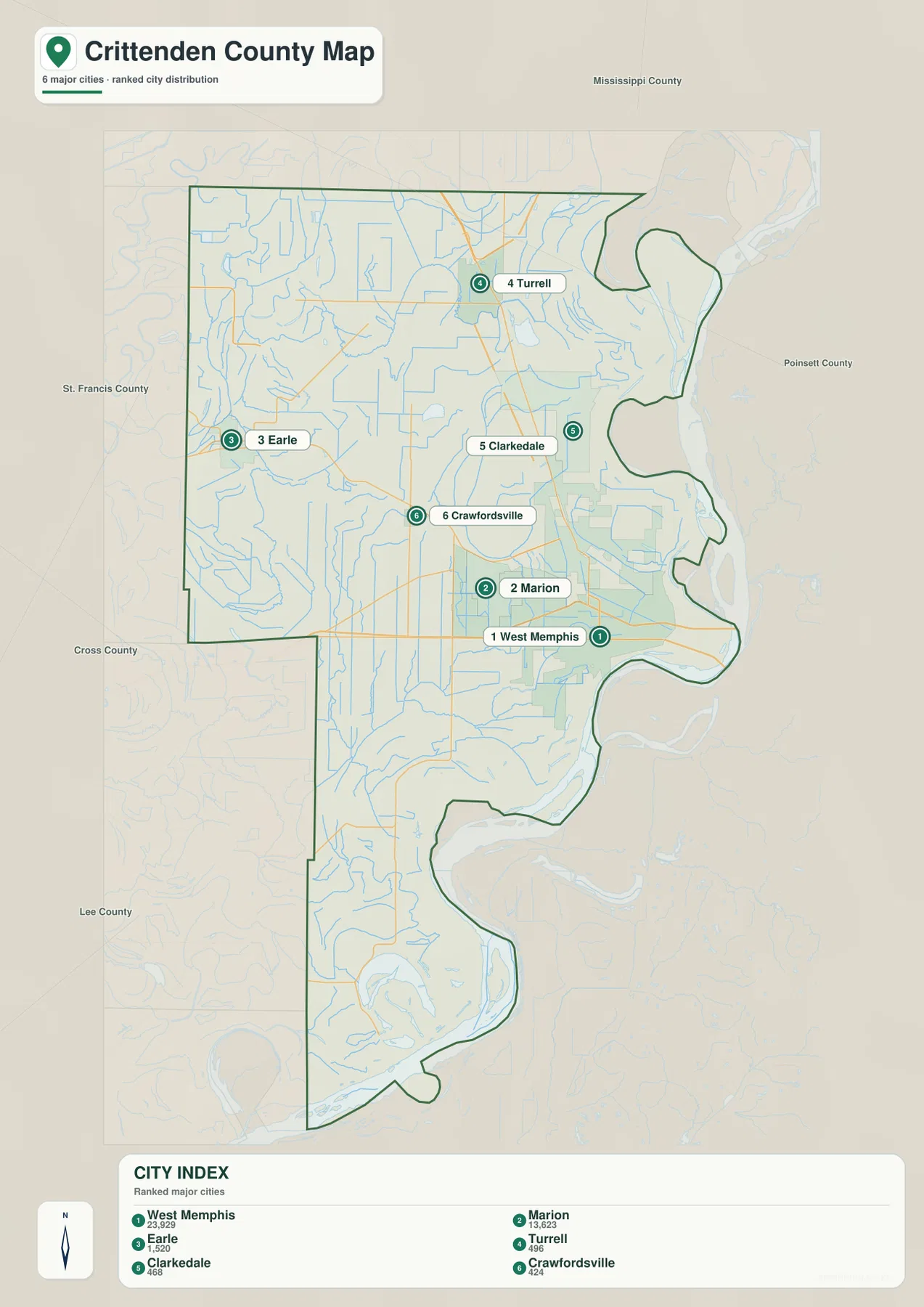
West Memphis is the largest urban area on the general map and the most obvious transportation reference. Interstate 40 approaches from the west, Interstate 55 comes down from the north, and both routes continue toward the Mississippi River crossing. US 64 and US 70 also pass through the urban area, while Route 79 appears near the eastern edge. The concentration of highways around West Memphis makes the city the easiest starting point for understanding how Crittenden County connects with Memphis and with the rest of Arkansas.
Marion sits immediately northwest of West Memphis and is the county seat. Route 64 passes through the area, and Route 218 reaches westward from Marion into the county interior. The two urban footprints nearly touch on the map, but their roles are different: West Memphis is more strongly associated with the interstate and river crossing, while Marion is the administrative center. Keeping both places in view is more useful than treating the eastern side as one undifferentiated city.
North of the main urban area, Sunset and Clarkedale lead toward Turrell. Interstate 55 and Route 77 continue through the Turrell area, and Gilmore lies farther north near Route 61. This section has far less urban coverage than West Memphis and Marion. Turrell and Gilmore are therefore useful boundary references, helping the reader see how far the county extends toward Mississippi County.
The western side is organized around smaller communities. Earle lies well to the west near Routes 149, 118, and 184. Crawfordsville is closer to the center and connects toward Route 64, while Jennette appears near the western portion of Interstate 40. These places are separated by large rural areas and many small water lines. Starting with Earle and Crawfordsville, then tracing the roads back toward Marion and West Memphis, makes the western half much easier to understand.
The six-city index reveals a strong eastern cluster and widely spaced smaller towns
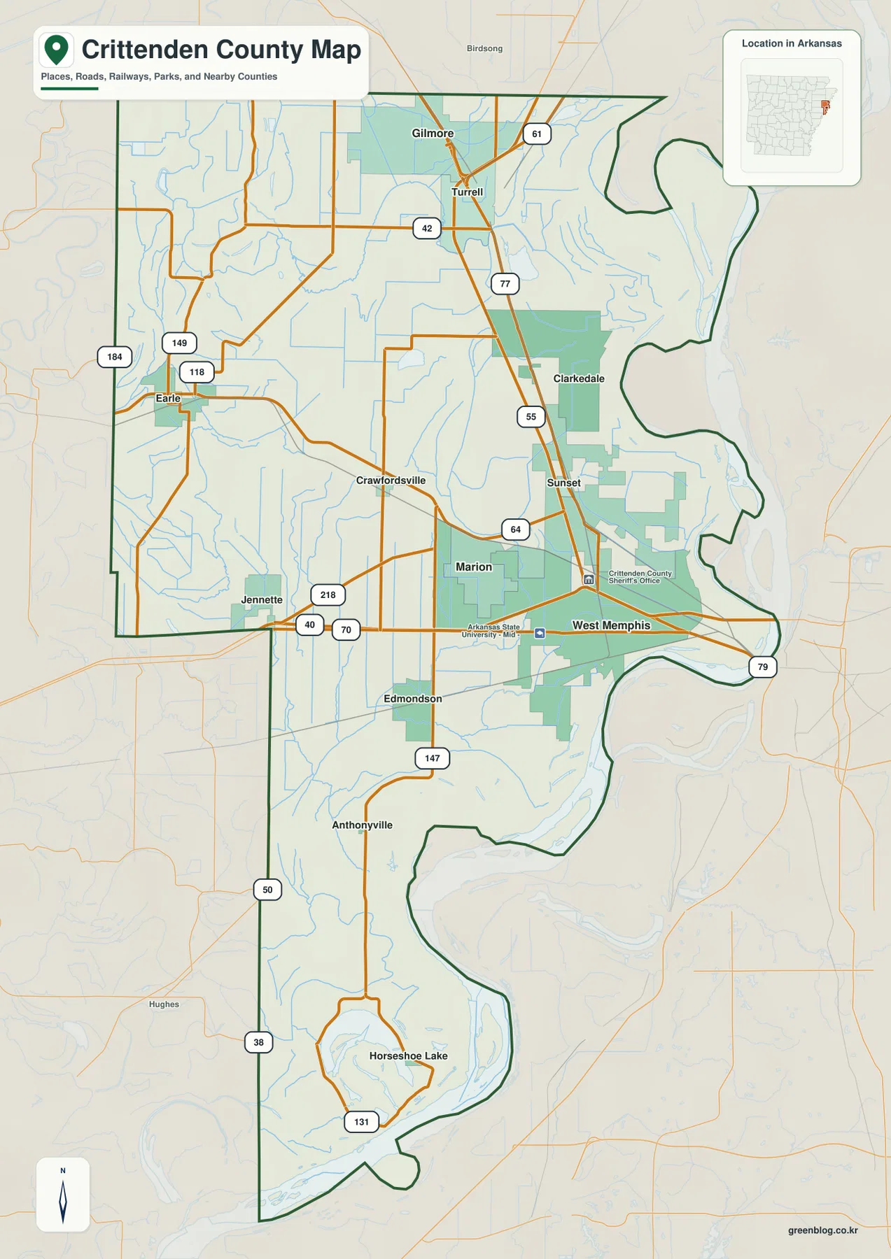
The city map highlights West Memphis, Marion, Earle, Turrell, Clarkedale, and Crawfordsville. West Memphis is ranked first and Marion second, followed by Earle, Turrell, Clarkedale, and Crawfordsville. By removing most secondary roads and smaller settlement labels, the layer makes the county’s uneven urban pattern immediately clear. West Memphis and Marion form one compact eastern cluster, while the other highlighted towns are separated from one another by much larger rural spaces.
Earle stands by itself on the western side. Crawfordsville is farther east but still well away from the West Memphis–Marion cluster. Turrell is close to the northern edge, and Clarkedale lies between Turrell and the main eastern urban area. This pattern is useful for understanding why the road map contains long stretches with few large place labels. The county’s settlement system is not a continuous corridor from east to west.
The city index printed on the supplied map lists West Memphis at 23,929, Marion at 13,623, Earle at 1,520, Turrell at 496, Clarkedale at 468, and Crawfordsville at 424. These figures are best treated as part of the supplied map’s ranking rather than as a substitute for current Census estimates. Their main value here is to show the large size difference between the two leading eastern cities and the smaller communities elsewhere in the county.
Neighboring Arkansas counties are labeled outside the boundary: Mississippi County and Poinsett County to the north, St. Francis and Cross counties to the west, and Lee County farther southwest. The eastern side is different because the Mississippi River separates Crittenden County from Tennessee. That river boundary helps explain the county’s long, irregular eastern outline and the unusual concentration of transportation infrastructure around West Memphis.
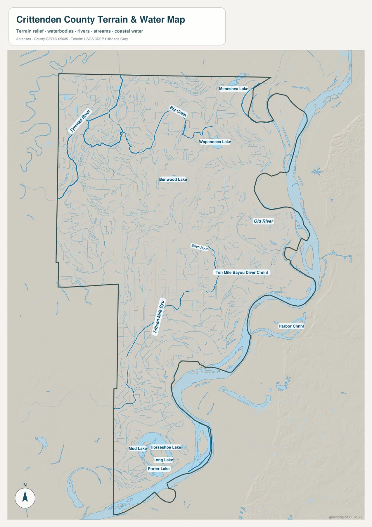
Mississippi River bends dominate the east while Tyronza River and Big Creek drain the interior
The Mississippi River is the largest water feature affecting the county. On the supplied water map, its broad channel follows the eastern and southern boundary through a series of sweeping bends. The river is not simply a straight border; large loops and cut-off forms shape the county outline. This is especially noticeable east of West Memphis and farther south, where the boundary curves around former and current river channels.
In the northwest, Tyronza River is one of the strongest labeled interior waterways. Big Creek occupies the north-central part of the county, and Wapanocca Lake and Benwood Lake appear nearby. Smaller channels spread through the low plain in many directions. On the road map this area may look relatively open, but the water layer shows that it is crossed by a dense network of natural and managed drainage features.
The center and south include names such as Ditch No. 9, Fifteen Mile Bayou, and Ten Mile Bayou Diversion Channel. Their nearly straight sections contrast with the larger natural bends of the Mississippi River. That difference fits the county’s history: the Encyclopedia of Arkansas notes the long importance of levees and drainage districts in making this low bottomland usable. The water map therefore reflects both natural river history and extensive drainage management.
Farther south, Horseshoe Lake, Mud Lake, Long Lake, and Porter Lake form a distinctive group. Horseshoe Lake is particularly easy to recognize because of its curved former-channel shape. Comparing it with the nearby Mississippi River bends shows how strongly river movement has influenced the local landscape. This layer is a geographic reference only; it does not show current water levels, flood probability, boat access, parcel boundaries, or legal shoreline limits.
A 48–84 meter elevation range exposes subtle floodplain relief rather than mountains
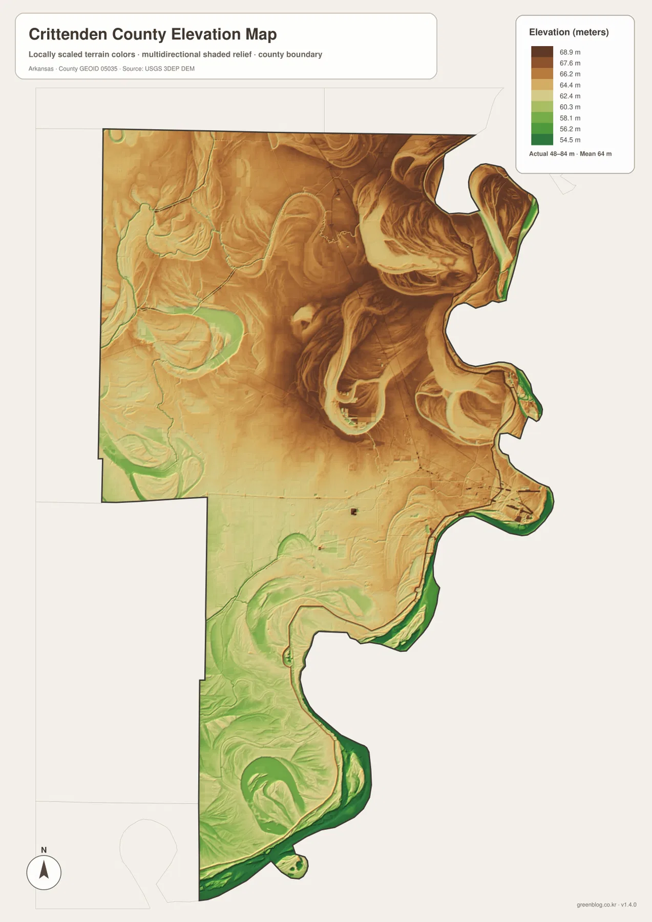
The elevation map reports a county-wide low near 48 meters, a high near 84 meters, and an average around 64 meters. Compared with western or northern Arkansas, that is an extremely small relief range. Most of the county is shown in closely related greens, tans, and browns. Even so, the shaded surface reveals slightly higher northern areas and broad lower zones toward the south and along active or former river channels.
The eastern boundary contains some of the most interesting shapes. Large curving depressions and narrow raised strips follow old Mississippi River meanders. Several horseshoe-shaped forms remain visible even where the current main channel lies elsewhere. When this map is compared with the hydrography layer, features such as Old River and other isolated water bodies become easier to place within the former-channel terrain.
The Horseshoe Lake area in the south is among the lowest-looking parts of the county. Green terrain surrounds the lake and continues toward the river bends. The Tyronza River side in the northwest is also low, but the pattern is less broad and more mixed with slightly higher ground. These differences are small in absolute elevation, yet they are meaningful enough to create visible floodplain forms across the map.
This elevation layer is designed for county-scale comparison, not flood certification or engineering. A 48–84 meter range can help explain where broad lowlands and slightly raised areas occur, but property-level flood safety depends on levees, drainage, official flood zones, current river conditions, and detailed elevation. Those decisions require FEMA products, detailed USGS data, or professional surveying rather than this overview map.
Three anchors make the county easier to remember: West Memphis, Marion, and the river
A practical mental map starts with West Memphis, Marion, and the Mississippi River. West Memphis is the main transportation center, Marion is the county seat, and the river creates the irregular eastern and southern boundary. From that core, Turrell can be added to the north, Earle and Crawfordsville to the west, and Horseshoe Lake to the south. This sequence is more useful than trying to memorize every secondary road or drainage ditch.
Moving north from the main urban area passes Clarkedale and Sunset before reaching Turrell and Gilmore. Moving west enters a more rural landscape toward Crawfordsville and Earle. Moving south leaves the largest city cluster behind and follows a much longer county section toward Edmondson, Anthonyville, and Horseshoe Lake. The terrain remains low throughout, but the density of settlements and the shapes of water features change noticeably from one section to another.
The general map is the best choice for highways and community locations, the city index simplifies settlement distribution, the water map explains rivers, lakes, and drainage channels, and the elevation layer reveals subtle high and low areas within the floodplain. Choosing the layer that matches the question is more effective than expecting one map to show every detail equally well.
The West Memphis–Marion urban area changes quickly once the map moves west. Near West Memphis, interstates, US highways, rail corridors, and the Mississippi River dominate the picture. West of Marion, however, the built-up area gives way to broad rural land crossed by local roads and drainage channels. Comparing the general map with the water layer makes that transition especially clear: the visual emphasis shifts from transportation infrastructure to creeks, ditches, and low floodplain terrain within a relatively short distance.
The southern extension toward Horseshoe Lake deserves to be treated as its own part of the county. Anthonyville and Horseshoe Lake are far from the main urban cluster, and the county narrows before reaching a landscape shaped by old river bends and low-lying lakes. On the elevation map this area is broadly green, while the water map is filled with curved channels and isolated water bodies. That combination makes the south easier to remember as a river-shaped landscape rather than simply the far end of the road map.
Use the full-resolution JPG files when small labels and river forms matter
The WebP previews are convenient for quick viewing, but the original JPG files are better for printing or close inspection. The ZIP below contains the county map, city map, water map, and elevation map at 2572 × 3638 pixels each. Small road numbers, drainage labels, lake names, and relief shading are easier to inspect at full resolution, making the files useful for lessons, presentations, reports, and personal reference.
Frequently Asked Questions
How are West Memphis and Marion positioned on the map?
They form a close urban pair on the eastern side of the county. West Memphis is centered on the I-40 and I-55 transportation network near the Mississippi River, while Marion lies immediately northwest and serves as the county seat. Locating these two cities first makes the rest of the county much easier to orient.
Which map is best for Horseshoe Lake and the Mississippi River bends?
The water map is the best starting point because it shows Horseshoe Lake together with the major river bends, nearby small lakes, and interior drainage channels. The elevation map adds useful context by showing that the southern lake area lies within some of the county’s lower terrain.
Can the 48–84 meter elevation layer be used as a flood-risk map?
No. It is a generalized county-scale elevation reference. Flood risk depends on levees, drainage, current river conditions, official flood zones, and detailed local elevation, so FEMA or other current agency products should be used for safety and property decisions.
Map File Information
The ZIP contains high-resolution JPG originals for the Crittenden County general map, city map, water map, and elevation map.
- Included Files: County map, city map, water map, elevation map
- Printable Size: 2572 × 3638 px each
- File Type: JPG
Related Maps
Sources and references
- Official Crittenden County website: county seat, communities, Mississippi River setting, and major transportation background.
- Encyclopedia of Arkansas – Crittenden County: county geography, Mississippi River bottomland, settlement history, levees, and drainage context.
- U.S. Census Bureau TIGER/Line Shapefiles: official reference for county boundaries, roads, and place geography.
- USGS National Hydrography: official reference for rivers, streams, lakes, and drainage features.
- USGS 3D Elevation Program: official elevation and terrain reference.
Green Map creates custom-edited map images using open geographic data sources such as geoBoundaries, Natural Earth, OpenStreetMap, and government open data.
These maps are edited visual materials, not raw data files, and are provided for education, documents, presentations, and graphic reference.