Carroll County in northwestern Arkansas is easiest to understand by starting with its two county seats, Berryville and Eureka Springs, and then following the roads, river valleys, and ridges that spread away from them. This page includes four map views of the same county: a boundary-and-road map, a city index, a water-and-terrain map, and an elevation map. You can also download the matching high-resolution JPG originals as a ZIP file on this page, so the maps are ready for printing, classroom use, presentations, or closer inspection without relying on a screen capture.
Most of the named communities cluster in the northern half. Berryville sits near the north-central part of the county, Eureka Springs lies to the west, Green Forest is southeast of Berryville, and Alpena appears close to the eastern boundary. Holiday Island and Oak Grove are farther north. Once you move into the broad southern half, fewer city labels appear, and roads, streams, valleys, and ridge lines become more useful for keeping your bearings.
The natural geography gives Carroll County a distinctive shape on the specialized maps. Kings River bends through the interior, Beaver Lake reaches the northwestern edge, and a network of smaller creeks crosses the eastern and southern sections. The elevation map reports an actual county range of about 277 to 704 meters, with a mean near 411 meters. Lower stream valleys and higher Ozark ridges repeat across the county, especially toward the south and southeast, which helps explain the winding road pattern seen on the general map.
Table of Contents
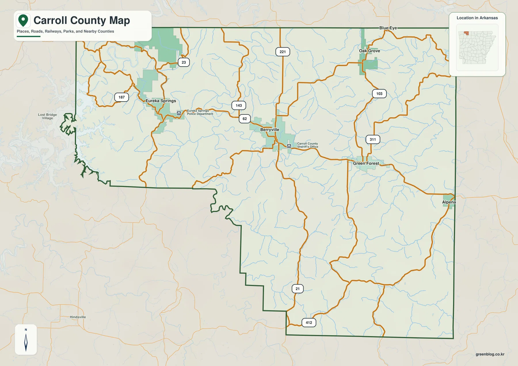
Berryville and Eureka Springs make the road map easy to orient
On the county map, Berryville works as a practical central reference point because several numbered roads meet around it. U.S. 62 runs from the Eureka Springs side through Berryville and continues toward Green Forest. Routes 143 and 221 are marked near Berryville, while 23 and 187 appear around Eureka Springs. Farther south, 21 and 412 provide another set of reference lines, making it easier to relate the busy northern settlement area to the much larger southern part of the county.
The western road pattern is noticeably more irregular than a simple grid. Around Eureka Springs and the Beaver Lake edge, roads curve around narrow valleys and broken ridges, while the county boundary itself has several sharp bends. East of Berryville, the routes spread toward Green Forest and Alpena, and 103 and 311 are visible in the northeastern section. This difference between the western hills and the more open-looking north-central and eastern routes is useful when you are trying to match a place name to its surrounding landscape.
Six labeled communities show how strongly settlement favors the north
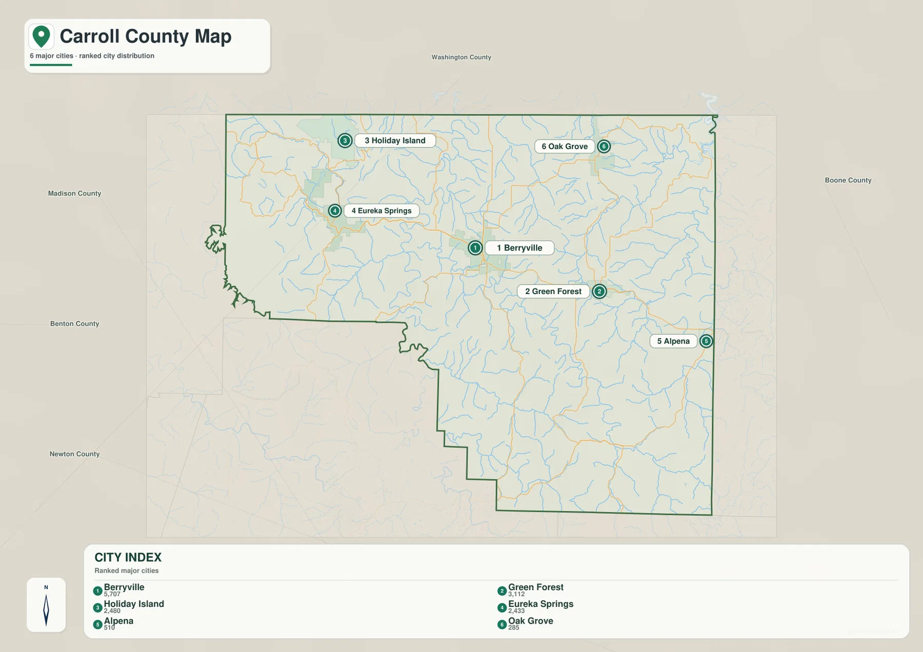
The city index highlights Berryville, Green Forest, Holiday Island, Eureka Springs, Alpena, and Oak Grove. Berryville and Green Forest form a close north-central to eastern pair, while Eureka Springs and Holiday Island occupy the western and northwestern side. Alpena sits against the eastern edge, and Oak Grove is farther northeast. Because all six labels lie in the northern half, the city map gives a very quick picture of where the county’s named population centers are concentrated.
That concentration should not be mistaken for an empty southern county. The southern section still contains roads, drainage lines, and rugged terrain, but it has fewer of the major city labels selected for this index. For general orientation, the city map is therefore best used alongside the county map rather than by itself. The surrounding labels for Benton, Madison, Boone, Newton, and Washington counties also help place Carroll County within the larger northwestern Arkansas region.
Kings River and Beaver Lake define the most recognizable water features
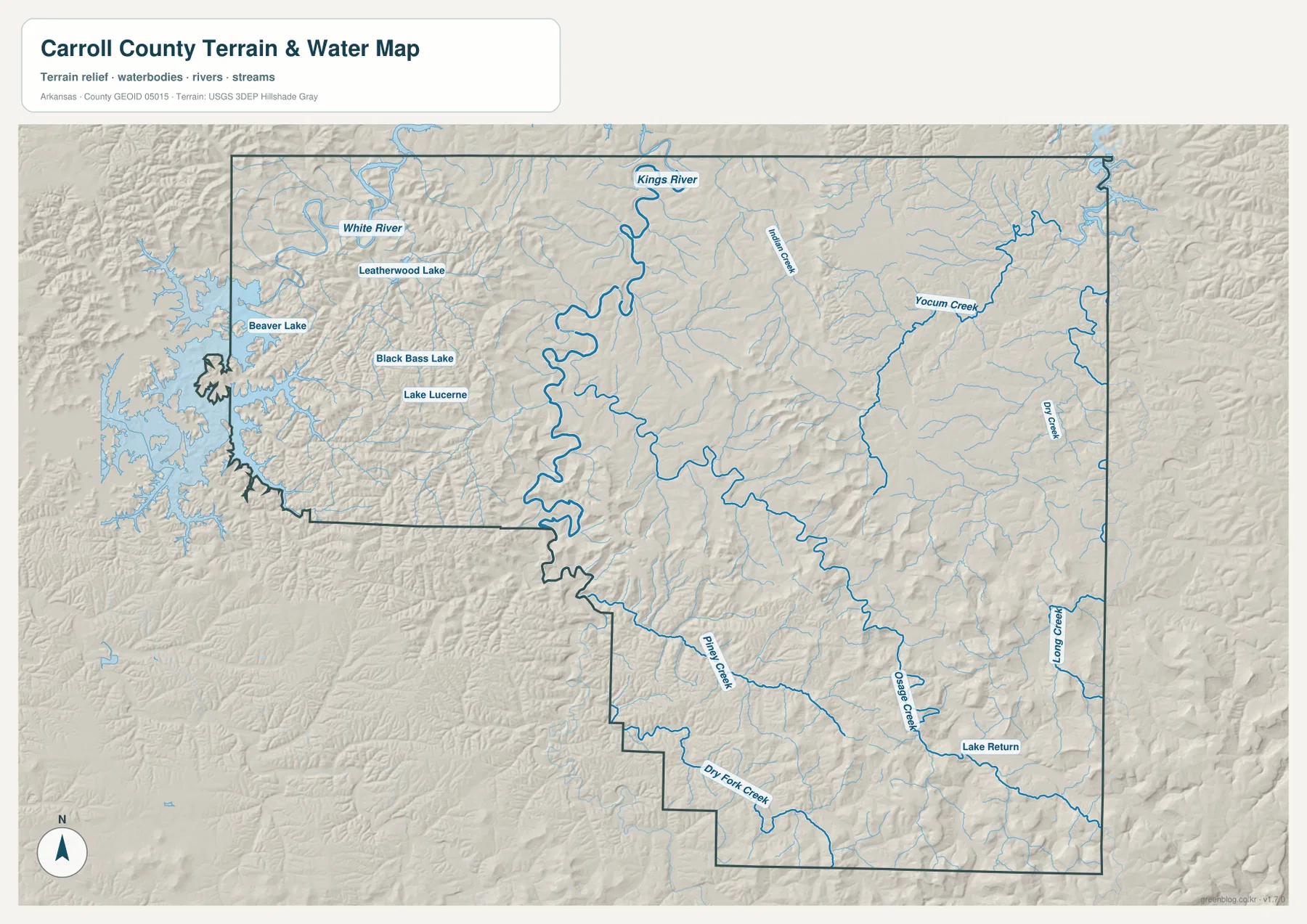
Kings River is the dominant interior water feature on the terrain-and-water map. It enters from the north, forms a series of large bends, and continues southward through the central-western part of the county as smaller tributaries join it. At the northwestern edge, Beaver Lake reaches into the county with an intricate shoreline, and the White River is labeled nearby. Around Eureka Springs, Leatherwood Lake, Black Bass Lake, and Lake Lucerne add several smaller but clearly marked water bodies to the western hills.
The eastern and southern portions are crossed by a different set of named streams, including Yocum Creek, Dry Creek, Osage Creek, Long Creek, Piney Creek, and Dry Fork Creek. These channels follow the folds of the terrain rather than forming a simple parallel pattern. The map is useful for identifying where rivers, lakes, and streams sit relative to the county boundary, but it is not a flood-hazard map, parcel map, legal shoreline survey, or navigation chart. For those purposes, use the current data published by the responsible agencies.
Elevation rises from stream valleys toward the high southern and southeastern ridges
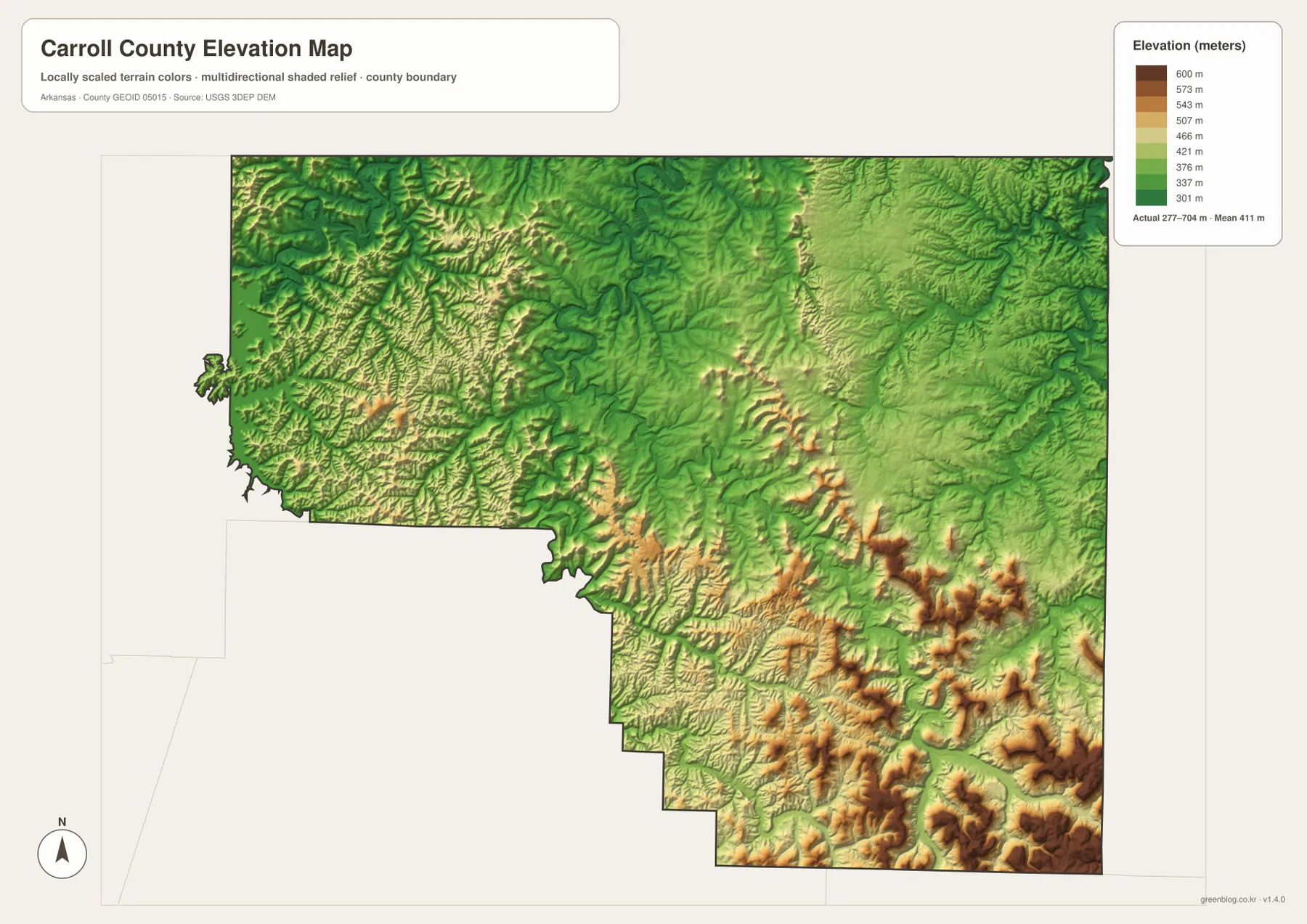
The elevation legend gives an actual county-wide range of about 277 to 704 meters and a mean near 411 meters. Green shades represent relatively lower ground, while yellow, tan, and brown mark progressively higher terrain. A broad lower zone appears across much of the north-central area, but the surface becomes more broken toward the south. The southeastern corner contains some of the darkest brown ridges and peaks, creating a strong contrast with the lower valleys elsewhere in the county.
Long green corridors often line up with river and creek valleys, including sections connected to Kings River and its tributaries. Between those valleys, ridges rise sharply, especially in the south and southeast. Western Carroll County around Eureka Springs and Beaver Lake also shows tightly folded terrain, which fits the twisting road pattern visible on the county map. This elevation surface is designed for county-scale comparison, not survey-grade measurement. Exact site elevations for engineering, drainage, construction, or property work require appropriate source data and field verification.
Choose the map by whether you need roads, communities, water, or relief
For trip planning or general location work, start with the county map because it keeps Berryville, Eureka Springs, major road numbers, and the boundary in the same view. The city index is cleaner when the main question is simply where the six labeled communities sit relative to one another. Use the water map when Kings River, Beaver Lake, White River, or the smaller creeks are the subject, and switch to the elevation map when the goal is to compare low valleys with the high ridges of the southern half. Keeping those purposes separate makes each map easier to read.
The WebP images in the article are sized for efficient viewing online. The downloadable ZIP contains the corresponding high-resolution JPG originals, with each image at 3638 × 2572 pixels. That larger size is helpful when road numbers, stream names, or small place labels need to stay legible on A3 paper, a full-slide presentation, or a printed handout. The archive contains one JPG for the county map, city map, water map, and elevation map, so you can use only the file that fits your task.
Frequently Asked Questions
Why are both Berryville and Eureka Springs useful reference points on a Carroll County map?
Carroll County has two county seats, Berryville and Eureka Springs, so both cities matter for administrative orientation. They also sit in different parts of the county, with U.S. 62 linking the western and north-central areas. Using both as reference points makes it easier to understand the county’s road network and the distribution of nearby communities.
Which map is best for finding Kings River, Beaver Lake, and the smaller creeks?
The terrain-and-water map is the clearest choice because those features are emphasized in blue and labeled directly. It shows the large bends of Kings River, the Beaver Lake and White River area in the northwest, several lakes near Eureka Springs, and named creeks in the eastern and southern parts of the county. Use the county map as a companion when you also need road and town context.
Can the 277–704 meter elevation range be used for surveying or construction?
No. The range summarizes the supplied county elevation map and is intended for comparing broad terrain differences. It does not provide a precise elevation for a parcel, road centerline, building pad, or engineering point. Surveying, construction, drainage design, and similar work require appropriate source data, professional methods, and site-specific verification.
Map File Information
The ZIP contains the high-resolution JPG originals for the Carroll County map, city map, water map, and elevation map.
- Included Files: County map, city map, water map, elevation map
- Printable Size: 3638 × 2572 px each
- File Type: JPG
Related Maps
Sources and references
Administrative information and the county-seat arrangement can be checked in the Association of Arkansas Counties Carroll County profile. General boundary, road, and place data are available through the U.S. Census Bureau TIGER/Line Shapefiles. Water-feature information can be cross-checked with USGS National Hydrography, while elevation data are available through the USGS 3D Elevation Program. The county-specific descriptions above prioritize the place names, roads, water features, and elevation range actually shown on the supplied Carroll County maps.
Green Map creates custom-edited map images using open geographic data sources such as geoBoundaries, Natural Earth, OpenStreetMap, and government open data.
These maps are edited visual materials, not raw data files, and are provided for education, documents, presentations, and graphic reference.