Mohave County stretches through northwestern Arizona in a long, irregular shape, and the supplied maps make the contrasts between its northern and southern areas easy to see. Colorado City appears near the far northern edge, Kingman provides a strong reference point in the south-central interior, and Bullhead City, Fort Mohave, Mohave Valley, and Lake Havasu City line up along the western and southwestern side. This page explains the places, numbered roads, waterways, and elevation shown in the provided map set. You can also download the four matching high-resolution JPG files in one ZIP for printing, presentations, or closer inspection.
A practical way to get oriented is to begin around Kingman. Roads 40, 66, 68, and 93 are all visible near the city, making it easier to relate Kingman to Bullhead City on the west and Lake Havasu City farther southwest. The far north looks quite different: Colorado City sits near Roads 15 and 389 and is separated from the main southern group of mapped cities by a large stretch of the county. The city-connections view reinforces that distance, while the water and elevation maps show why a simple road map does not tell the whole story of Mohave County’s terrain.
Table of Contents
Kingman is the easiest road reference in the main southern section
The general county map gives Kingman the clearest concentration of road labels. Golden Valley lies immediately to the west, followed by Bullhead City closer to the Colorado River side. To the northwest, Dolan Springs and White Hills form another line of named places, with Meadview and Grand Canyon West appearing farther north. This arrangement makes Kingman useful as a visual anchor: once it is located, the other towns and route numbers can be followed outward without having to scan the entire county at once.
Road 68 runs west from the Kingman area toward Bullhead City, while Road 66 is labeled east of Kingman. Roads 40 and 93 also appear close to the city. In the southwest, Road 95 is marked near Lake Havasu City, and the northern tip has a very different pair of prominent numbers, 15 and 389, near Colorado City. The map is designed for county-scale orientation rather than detailed turn-by-turn travel, but it clearly shows how the road pattern changes between the Kingman area, the Colorado River communities, and the distant northern section.
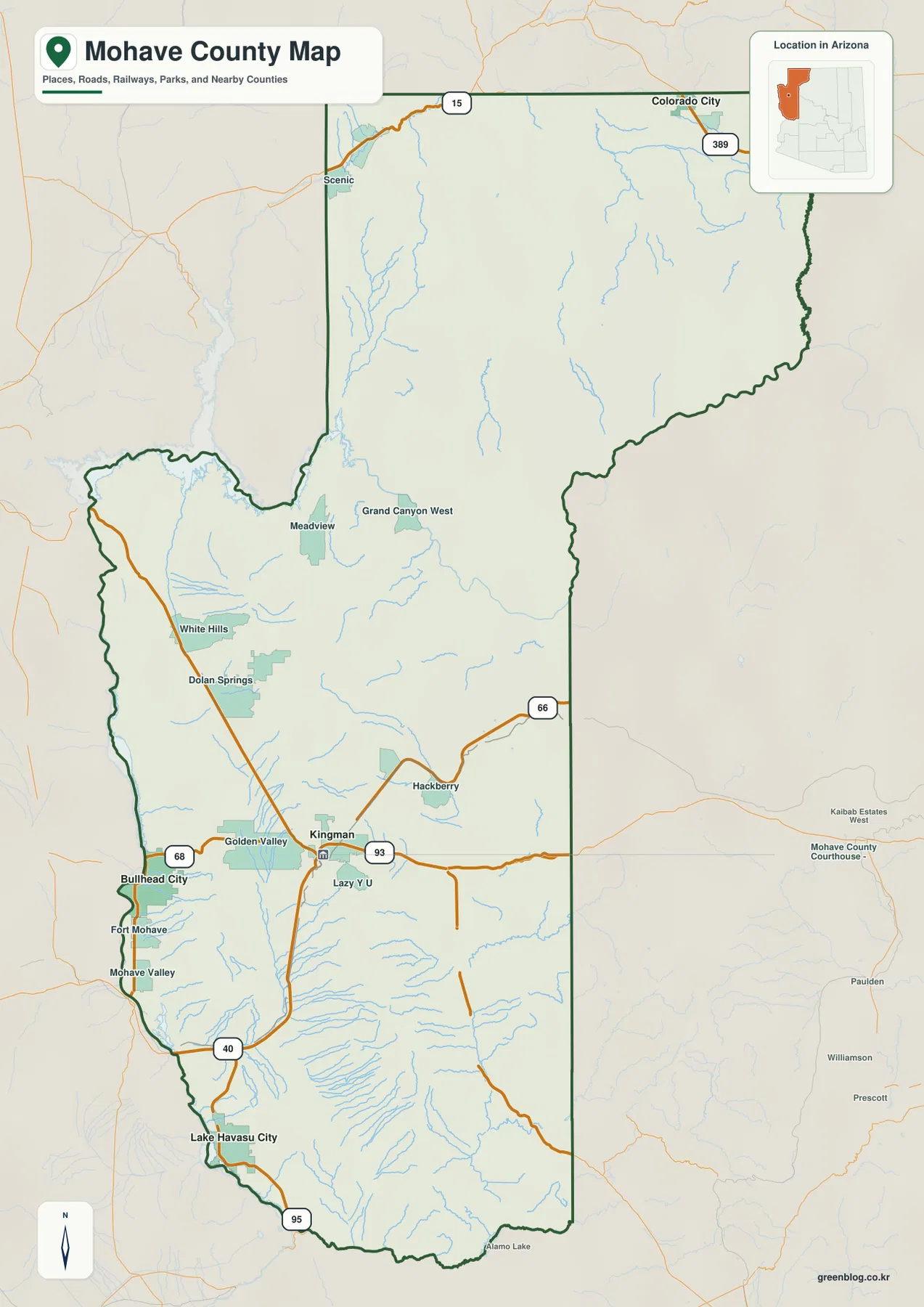
The western side contains a close sequence of named communities. Bullhead City is followed southward by Fort Mohave and Mohave Valley, with Lake Havasu City much farther down the county. East of the boundary, labels for Yavapai County and Coconino County provide useful orientation, while the small Arizona inset places Mohave County in the state’s northwest corner. These features are enough for regional context, but the map should not be used to settle a property-line question, locate an individual address, or replace an official parcel product.
Lake Havasu City serves as the hub on the city-connections map
The city view simplifies the county and uses Lake Havasu City as its hub. From that point, the map lists Bullhead City at about 44 miles, Kingman at about 53 miles, and Colorado City at about 185 miles. The legend identifies these as direct distances, so they should be understood as straight-line measurements rather than driving mileage. Roads bend around terrain and do not always provide a direct connection, which means an actual trip can be substantially longer than the number printed on this map.
The city positions are more important here than the road detail. Lake Havasu City sits near the southwestern edge, Bullhead City is farther north along the west side, and Kingman lies inland to the east. Colorado City is isolated at the far northern end of the county. The surrounding labels for La Paz County, Yavapai County, and Coconino County help keep those locations in context. For a classroom slide or a quick county overview, this simplified view is often easier to read than the full road map.
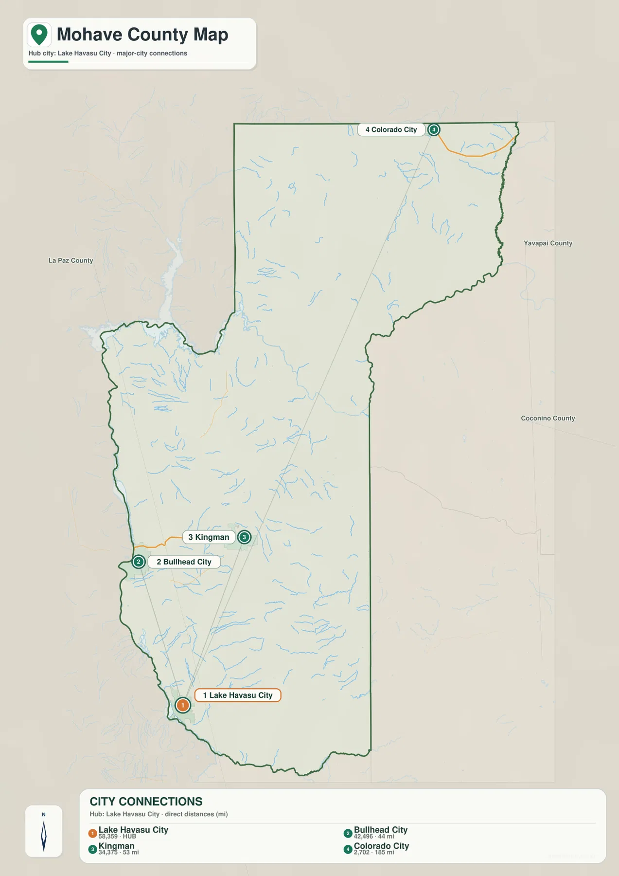
The figures printed beside the city names were part of the supplied map’s city dataset. They should not automatically be treated as current population estimates. If the latest population or municipal statistics are needed, use a current Census Bureau or local-government source. For this article, the value of the city map is the clear separation between the four labeled places and the straight-line distance comparison from the Lake Havasu City hub.
The Colorado River edge contrasts with a web of creeks and washes inland
The terrain-and-water view puts the Colorado River in a prominent position along the western side of the county. Farther north, a broad water area is visible near the Danger Bay label, while the interior is crossed by many thinner blue channels. The map includes both rivers and features labeled as washes. A wash is a dry or intermittent channel that can carry water after rainfall, so it should not be assumed to behave like a continuously flowing river simply because it is drawn in blue.
Several names help break the large county into recognizable sections. Wolf Hole Lake and Lakes of Short Creek appear in the north, with Cottonwood Wash also labeled in that area. Lost Creek is marked nearer the center. Farther south, Detrital Wash, Silver Creek Wash, Mackenzie Wash, Knight Creek, and Trout Creek are visible, and Big Sandy River stands out in the southeast. Many smaller channels are unlabeled at this scale, but together they show how frequently valleys cut through the mountainous interior.
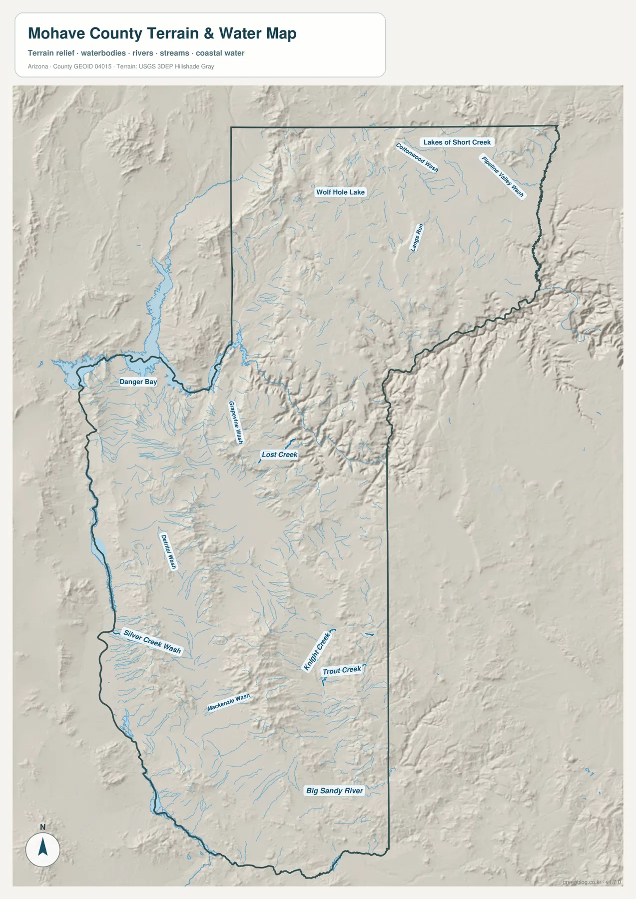
The shaded relief makes the relationship between the channels and surrounding high ground easier to see. The central and eastern portions contain many sharp ridges and valleys, while broad lower areas occur closer to the western river corridor. This map is meant for geographic reference only. It does not show current water level, flood probability, water depth, legal access, or navigation conditions. Flood planning and other safety-sensitive work should use the latest authoritative products created for those purposes.
Elevation rises sharply from the western lowlands into northern and central high ground
The elevation map reports an actual range of about 137 to 2,500 meters and a mean elevation of roughly 1,134 meters. Green colors represent lower terrain, while yellow, tan, and brown indicate progressively higher ground. A broad green zone follows much of the western side and continues into the southwest. In contrast, extensive brown high ground appears in the north and across several central mountain areas. The large spread between the minimum and maximum is one of the clearest features in the supplied map set.
The north is not uniformly high. Lower green terrain enters the northwestern side, while higher plateaus and mountain forms dominate farther east and south. In the central part of the county, elongated high areas are separated by lower valleys, and the southern half contains isolated mountain blocks rising above broader low ground. When this image is compared with the water map, many of the smaller channels can be seen following lower cuts between the ridges. The elevation view therefore adds useful context to roads and place names without requiring the reader to infer terrain from a flat boundary map.
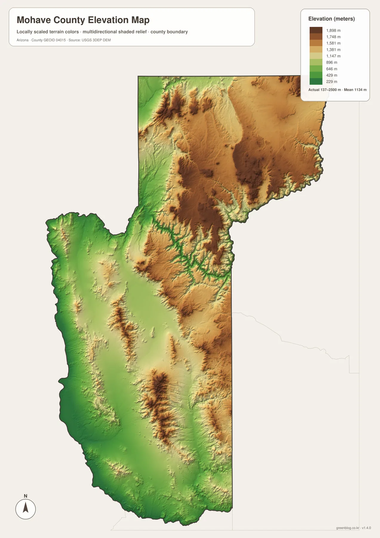
This surface is appropriate for countywide comparison, not survey-grade measurement. Elevation can vary inside a single color band, and small ridges or gullies may be simplified at the map’s scale. It works well for explaining relative high and low areas, but construction, engineering, site drainage, and property-level work should rely on original elevation data or a professional survey rather than a generalized county map.
Use each map for the question it answers best
Start with the general county map when you need roads, place names, and the overall boundary. Use the city-connections view when the main question is how Lake Havasu City, Bullhead City, Kingman, and Colorado City are positioned relative to one another. The terrain-and-water map is more useful for the Colorado River, Big Sandy River, creeks, and washes, while the elevation map makes the contrast between western lowlands and northern or central high ground much easier to explain. Keeping those tasks separate prevents the maps from becoming cluttered with labels that are not relevant to the reader’s immediate goal.
The WebP images in the article are intended for quick on-page viewing. For printing, enlarged labels, or presentation work, download the high-resolution JPG versions from the ZIP below. The archive contains four separate files matching the county, city-connections, terrain-and-water, and elevation views shown here. If a map is cropped for a slide or handout, keeping the county outline, legend, and north arrow visible will make the result easier for someone else to interpret.
Check current official sources when the map is not detailed enough
These maps are designed to explain the county at a broad scale. They do not include every local road, building, parcel, or government-service detail. The city-connection numbers are direct distances rather than road mileage, the water map is not a flood-risk product, and the elevation surface is not a survey. Address research, land ownership, construction, emergency planning, and legal-boundary questions should always be checked against current authoritative information created for that specific purpose.
The official Mohave County website is a useful starting point for current county services and contact information, and it lists the county’s main contact address in Kingman. Mohave County Parks provides additional local information about county park and recreation areas. Those sources can add current context, while the maps on this page remain focused on the visible geographic relationships: where the main places sit, which numbered roads appear, how waterways cross the county, and where the terrain rises or falls.
Frequently Asked Questions
Where is Kingman on the Mohave County map?
Kingman appears in the south-central interior of the county, close to Roads 40, 66, 68, and 93. Golden Valley is immediately to the west, Bullhead City is farther west near the Colorado River side, and Lake Havasu City lies to the southwest. The general county map is the most useful view when you need both the city position and nearby road numbers.
Are the 44-mile and 53-mile city distances driving distances?
No. The city-connections map identifies them as direct distances from Lake Havasu City. Bullhead City is shown at about 44 miles and Kingman at about 53 miles in a straight line. Actual driving mileage depends on the available road route and should be checked with current navigation information.
Can the 137–2,500 meter elevation range be used for a site survey?
No. The range is useful for comparing high and low terrain across the county, but it does not provide survey-grade elevation for an individual site. Engineering, construction, or property-level elevation work should use original USGS data or a professional survey appropriate to the project.
Map File Information
Download the high-resolution Mohave County JPG maps in one ZIP. The county, city-connections, terrain-and-water, and elevation views are stored as separate files.
- Included Files: county map, city-connections map, terrain-and-water map, elevation map
- File Type: ZIP containing 4 high-resolution JPG files
Related Maps
Sources and reference data
- Official Mohave County website – current county services and contact information.
- Mohave County Parks – county park and recreation information.
- U.S. Census Bureau TIGER/Line Shapefiles – reference data for county boundaries and geography.
- USGS National Hydrography – official reference for rivers, streams, and hydrographic data.
- USGS 3D Elevation Program – elevation data and 3DEP information.
Green Map creates custom-edited map images using open geographic data sources such as geoBoundaries, Natural Earth, OpenStreetMap, and government open data.
These maps are edited visual materials, not raw data files, and are provided for education, documents, presentations, and graphic reference.