Four high-resolution JPG maps of Hand County are available here as a single ZIP download. To understand the county itself, start near Miller and look outward to the small communities, creek valleys, and higher ground that fill this long north-south part of central-eastern South Dakota. Miller sits near the middle of the mapped road network, with Ree Heights to the west and St. Lawrence just to the east. The maps then let you compare county boundaries and roads, the direct-distance relationship among those three places, named streams and lakes, and an elevation range of about 403 to 669 meters.
The county does not look the same from one end to the other. The northwest corner and a broad part of the southwest show higher terrain, while much of the eastern and northeastern side lies lower. Waterways become denser where those lower corridors cut through the county, especially around Turtle Creek, Little Turtle Creek, and several smaller tributaries. Because the four map views use different labels, it helps to remember Miller’s central position first and then match the county outline and north arrow when moving to the water and elevation maps.
Table of Contents
Miller is the road-map anchor near the middle of Hand County
The general county map places Miller a little south of the county’s midpoint, where several roads meet. Hand County’s official website lists the Hand County Courthouse at 415 W. 1st Ave. in Miller, so the town is also a practical civic reference point when reading the map. Route number 45 continues south from Miller, while the 14 marker appears on the road running east from town. Ree Heights is labeled to the west, and Millerdale Colony appears farther to the southwest.
Farther north, the map shows a broad grid of east-west and north-south roads crossing a landscape with many small drainage lines. The county outline also narrows in its southern half after a noticeable step in the boundary. That shape matters when comparing the maps: the lower part of the county is not simply a continuation of the wider northern rectangle, and the boundary provides an easy visual check when the city names disappear from the water or elevation view.
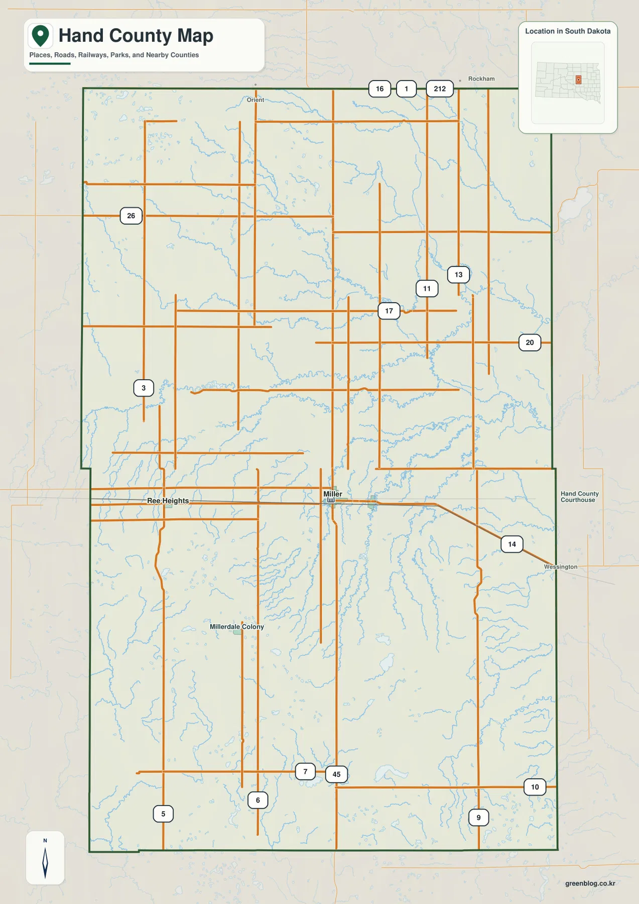
This is the most useful view when the question begins with a place name or road number. If you want to locate Miller and follow the road south, the 45 marker gives a clear reference. If you want to understand where Ree Heights sits before switching to the simpler city map, the general map provides the surrounding road context. The streams are visible here too, but their names and relative prominence are easier to read on the dedicated waterways map.
A short east-west chain links Ree Heights, Miller, and St. Lawrence
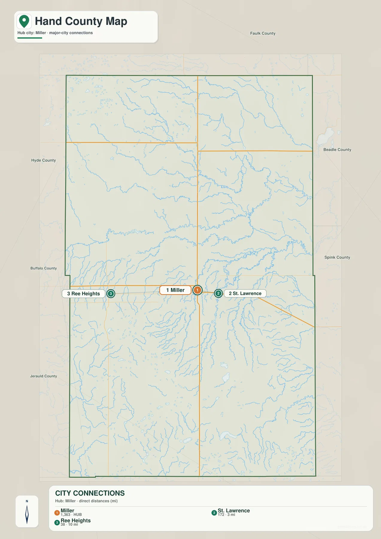
The city-connections map strips away most of the road detail and focuses on three places. Miller is marked as the hub, St. Lawrence lies to the east, and Ree Heights lies to the west. The layout makes the relationship unusually simple compared with counties where the main communities are scattered in several directions. It also makes clear that St. Lawrence is much closer to Miller than Ree Heights is.
The map labels the Miller-to-St. Lawrence connection at about 3 miles and the Miller-to-Ree Heights connection at about 10 miles. Those are straight-line distances, not driving mileage. Road travel can be longer depending on the actual route, intersections, and starting point, so the numbers should be used for relative location rather than navigation or travel-time estimates.
Ree Heights also has a useful local-history reference. The South Dakota State Historical Society’s marker catalog includes the Ree Heights Roadside Park marker and describes the community’s early settlement history, including its 1882 platting and the rolling grassland known as the Ree Heights south of town. That history is not needed to use the map, but it gives the western place name more context and helps distinguish it from a generic point label.
Turtle Creek and its neighbors organize the water map south of the midpoint
The waterways map reveals a much more intricate landscape than the road map suggests. Turtle Creek runs roughly north-south through the south-central part of the county, while Ree Creek follows another long north-south course to its west. Little Turtle Creek crosses the central area farther north, and the upper half of the county includes Lost Creek, Shue Creek, and Wolf Creek. These named streams stand out in blue against a background of many smaller drainage lines.
Several lakes provide useful landmarks between the creeks. Lake Louise sits west of the county’s center. Jones Lake and Pearl Lake are close to the Turtle Creek area, while Wall Lake and Spring Lake appear farther south. Rose Hill Lake is marked toward the southeast. The distribution is important: Hand County is not dominated by one large lake or one major river. Instead, small lakes and branching creeks are spread across different parts of the county.
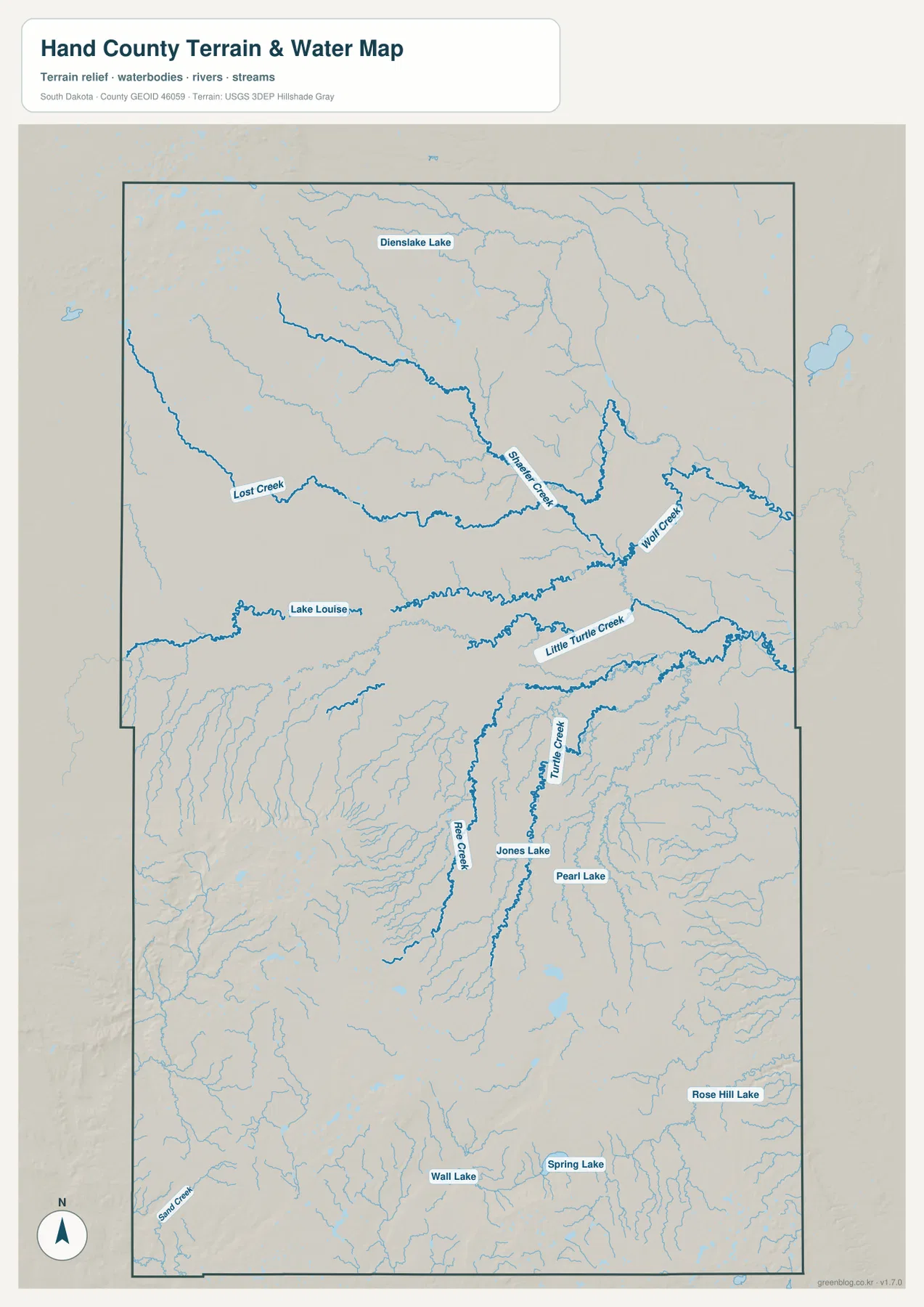
The south-central creek network becomes even more useful when compared with relief. On the elevation map, the southern half contains broad areas of higher ground cut by lower corridors. Remembering where Turtle Creek and Ree Creek run helps explain why those narrow lower bands appear inside a generally higher southern landscape. The upper tributaries tell a similar story on a smaller scale, with lower drainage paths extending toward the eastern side of the county.
This water map is a geographic reference, not a flood-risk, parcel, depth, or navigation product. It does not establish legal water boundaries and should not be used to plan a boat route or evaluate a property’s flood exposure. Its strength is simpler: it shows where named creeks and lakes sit relative to the county outline and to one another.
The 403–669 m elevation range separates the southwest hills from the lower east
The elevation legend reports an actual county range of roughly 403 to 669 meters, with a mean near 506 meters. The strongest high-elevation colors cover much of the southwest and south-central area, and another high patch occupies the northwest corner. In contrast, large parts of the eastern and northeastern county are shown in green, indicating lower ground. The difference is large enough to make the county’s internal relief visible immediately, even without contour lines.
The southern high ground is not one smooth block. Narrower low corridors cut through it, and their placement makes more sense after looking at Turtle Creek and Ree Creek on the waterways map. In the northern half, the color transition generally moves from higher ground in the west toward lower terrain in the east. The eastern side therefore reads as a broader low area connected to several drainage paths rather than as a simple flat strip.
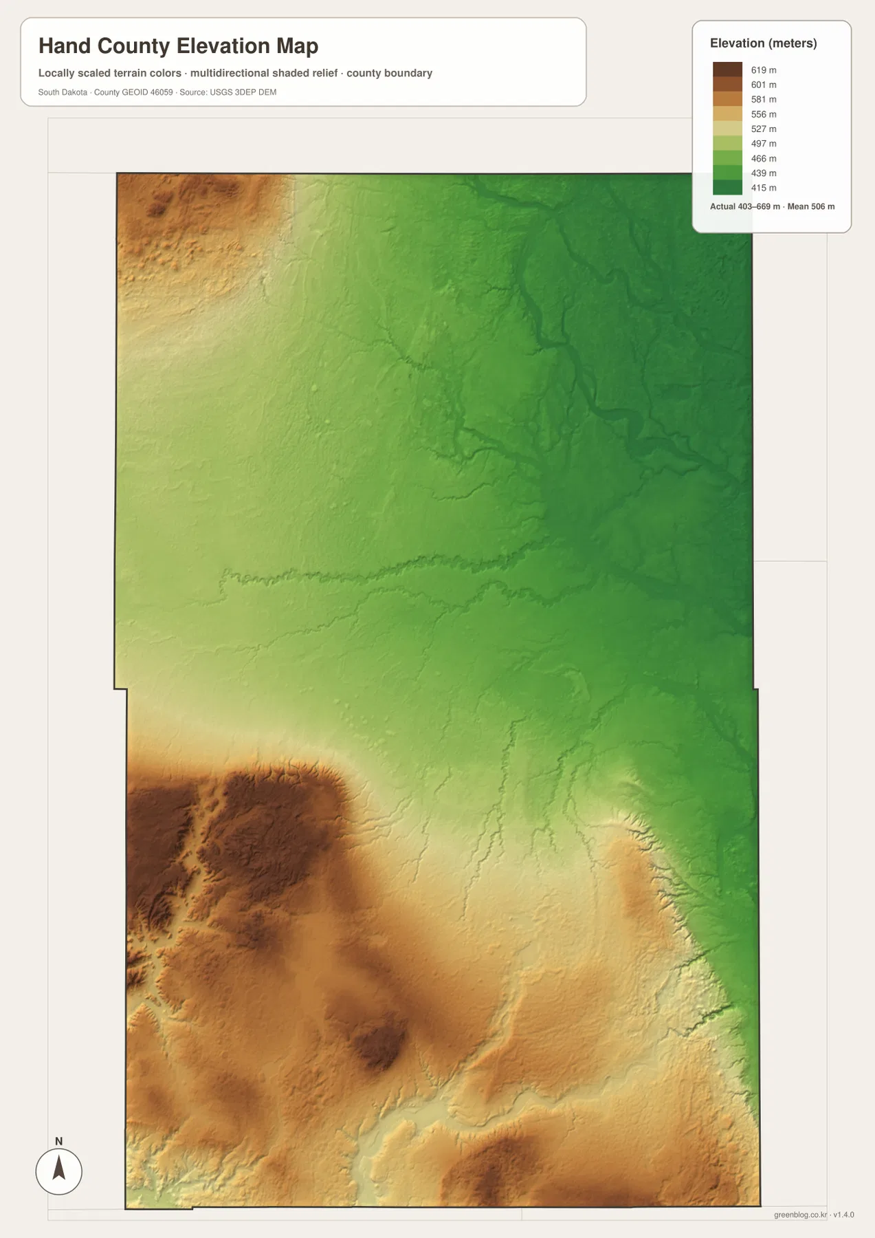
Miller is not labeled directly on the elevation image, so the map should not be used to read a precise elevation for the town. A better method is to remember Miller’s position on the general map and align the county outline. From there, the road heading south from Miller enters progressively higher terrain, while the area east toward St. Lawrence sits closer to the broad lower colors. Ree Heights, on the western side, is associated with generally higher colors than the eastern part of the county.
The relief image is also not a survey-grade elevation source. It is useful for county-scale comparisons—higher versus lower ground, creek valleys versus surrounding hills, and broad changes across the map. Construction, drainage design, engineering, or property-level work requires the underlying elevation data and site-specific surveying rather than this generalized county display.
Use Miller as a reference, then switch maps to answer a narrower question
A practical way to use the set is to begin with Miller on the general map and then change views only when the question changes. For community locations, the city map quickly shows that St. Lawrence is the close eastern neighbor and Ree Heights is farther west. For a water feature such as Turtle Creek or Lake Louise, the waterways map removes road clutter and makes the labels easier to find. For broad landform questions, the elevation map explains why the southwest looks more rugged and why the east appears lower.
Consider a simple example. If you are studying the area south of Miller, first follow the 45 road marker on the general map. Then use the waterways map to see where Turtle Creek and Ree Creek pass through the southern half. Finally, compare the elevation view and notice how the creek corridors cut through a wider area of higher terrain. That sequence connects a road location, a named water feature, and the county’s relief without pretending that any single map contains every detail.
The WebP images in the article are sized for convenient on-screen reading. The download archive contains the original high-resolution JPG versions of the general county map, city-connections map, waterways/terrain map, and elevation map. Each JPG is 2572 × 3638 pixels, so the originals are the better choice when you need to zoom in, prepare a presentation, or print at a larger size such as A3.
Frequently Asked Questions
Are the 3-mile and 10-mile city connections driving distances?
No. The city-connections map uses straight-line distance from Miller. St. Lawrence is shown at about 3 miles and Ree Heights at about 10 miles in direct distance. Actual road mileage can be longer, so route planning and travel-time estimates should use current road directions instead.
Which map is best for finding Turtle Creek, Lake Louise, and the smaller lakes?
The waterways/terrain map is the best starting point because the named creeks and lakes are emphasized in blue. Turtle Creek, Little Turtle Creek, Ree Creek, Lake Louise, Jones Lake, Pearl Lake, Wall Lake, Spring Lake, and Rose Hill Lake can all be located there. Use the elevation map afterward if you also want to compare the surrounding high and low ground.
Can the 403–669 m elevation range be used for surveying or construction?
No. The range summarizes county-scale relief and is useful for understanding broad differences between the higher southwest and the lower east. It is not a site survey and does not provide engineering-grade elevation at a specific road, building, or parcel. Detailed work should use original USGS elevation data and professional field measurements where required.
Map File Information
The ZIP contains the original high-resolution JPG files for the Hand County general map, city-connections map, waterways/terrain map, and elevation map.
- Included Files: 4 JPG maps
- Printable Size: 2572 × 3638 px each
Related Maps
Sources and references
- Hand County, South Dakota – Departments – Official county information, including the Hand County Courthouse in Miller.
- South Dakota State Historical Society – Historical Markers Master List – Includes the Ree Heights Roadside Park historical marker entry.
- U.S. Census Bureau TIGER/Line Shapefiles – Official geographic reference data for county boundaries and related features.
- USGS National Hydrography – Official U.S. Geological Survey information for streams, rivers, and waterbodies.
- USGS 3D Elevation Program – Official information about U.S. elevation data and 3DEP.
Green Map creates custom-edited map images using open geographic data sources such as geoBoundaries, Natural Earth, OpenStreetMap, and government open data.
These maps are edited visual materials, not raw data files, and are provided for education, documents, presentations, and graphic reference.