You can download high-resolution JPG map files for Charles Mix County, South Dakota, after reviewing the county views on this page. The county stretches a long distance from the Platte area in the northwest toward Wagner and Dante in the east, while the Missouri River bends along much of the southwest and southern edge. Major road references include SD 44, SD 45, US 281, SD 50, US 18, and SD 46. The supplied maps also show Wagner, Platte, Lake Andes, Pickstown, Geddes, Dante, named bays and creeks, and an elevation range of 371 to 642 meters.
Charles Mix County is easiest to understand by combining two strong reference features: the Missouri River boundary and the north-south position of US 281. Platte and Geddes lie toward the western side, Lake Andes occupies the south-central interior, and Wagner is farther east. Pickstown sits close to the river, while Dante is near the southeastern side. This spread of places means that a single town does not explain the county; the road, water, and elevation views each add something different to the same long landscape.
Table of Contents
The Missouri River turns the southern boundary into a long series of bends
The general county map shows a strong contrast between the river-shaped southwest and south and the straighter boundary segments elsewhere. From the northwestern end, the county line follows the broad blue river corridor through repeated bends before continuing along the south. The northern and eastern sides contain longer straight segments, so the water-shaped edge is one of the easiest ways to recognize Charles Mix County on the page.
Platte appears in the northwest near SD 44 and SD 45. Geddes lies farther southeast, and US 281 provides a useful central reference as it crosses the county from north to south. Ravinia and Wagner are shown farther east, with Wagner close to the US 18 and SD 46 corridor. Marty is well south of Wagner near the river side of the county, and Dante appears still farther southeast.
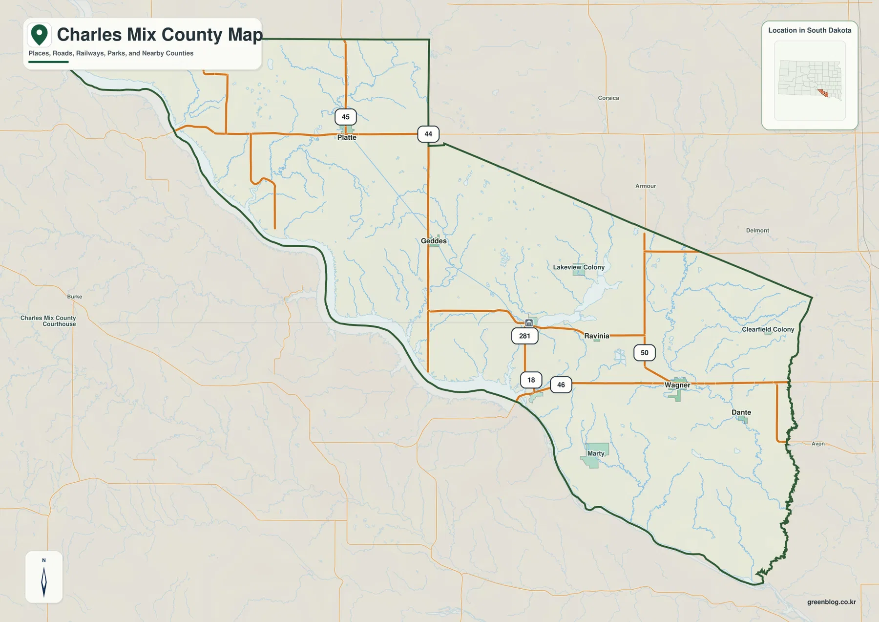
SD 50 is another useful marker on the eastern half of the map, while SD 44 provides the clearest east-west reference in the northwestern section. The general map also labels Lakeview Colony in the north-central area and Clearfield Colony east of Wagner. These smaller names help fill the large spaces between the better-known towns and make the county’s long east-west spread easier to judge.
This road-and-boundary view is intended for orientation rather than live travel planning. It shows where communities and major routes sit in relation to one another, but it does not report current roadwork, closures, weather, or travel time. Those details should be checked with a current transportation or navigation source before a trip.
Wagner, Platte, and Lake Andes anchor different parts of the city distribution
The city-index image ranks six labeled communities and makes their positions easier to compare without the full road network. Wagner is marked number 1, Platte number 2, Lake Andes number 3, Pickstown number 4, Geddes number 5, and Dante number 6. The arrangement is useful because the six places are not clustered around one hub: Wagner and Dante are on the eastern side, Platte and Geddes are west of center, and Lake Andes and Pickstown sit closer to the southern interior and river corridor.
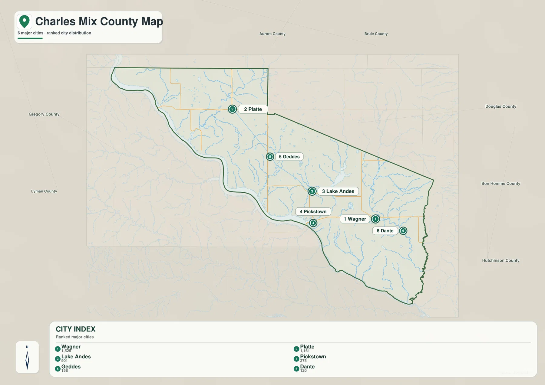
Values printed in the CITY INDEX are Wagner 1,529, Platte 1,161, Lake Andes 901, Pickstown 275, Geddes 158, and Dante 120. This article treats those figures only as values printed on the supplied image, not as a statement of the latest population estimates. For current population information, the U.S. Census Bureau should be checked directly.
Lake Andes is especially useful as a reference because it sits near the south-central part of the county, between the western places and Wagner. The official Charles Mix County website states that the county courthouse is located in Lake Andes. Pickstown is closer to the Missouri River, so it is easy to connect its city-index position with the water map. Platte, by contrast, is far to the northwest and works better with SD 44 and SD 45 as road references.
The city-index image deliberately simplifies roads and is not meant to replace the general county view. After locating a town on the index, return to the road map if you need to understand which numbered route reaches that part of the county. This is particularly useful for comparing Platte with Wagner or for seeing how Pickstown sits relative to the US 281 corridor and the river.
Bays and creeks break up the Missouri River side of the county
The terrain-and-water view makes the Missouri River the dominant feature along the southwest and south. Whetstone Bay, Odenbach Bay, and Joe Days Bay are labeled along the river, giving names to several of the broad indentations visible on the boundary. In the northwest, Snake Creek and Platte Creek descend toward the river, while Eagleston Creek runs farther inland.
Moving eastward, Pease Creek and Spring Creek are labeled in the central part of the county. Goose Lake and Lake Andes appear near the middle-southern interior, allowing the city name Lake Andes to be connected directly with a visible water feature. The map is crowded with smaller blue lines, so it is much more informative for drainage names than the road-focused county image.
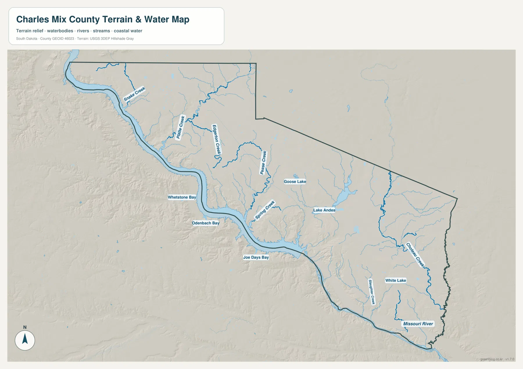
On the eastern side, Choteau Creek forms one of the longest clearly labeled stream lines, and Slaughter Creek appears farther south near the Missouri River. White Lake is labeled in the southern interior between the stream systems. These features show that the eastern half is crossed by substantial named waterways even though the large Missouri River sits along the opposite edge.
This map is a water-location reference, not a current hydrologic report. It does not show live river stage, discharge, flood risk, water quality, or boating conditions. Anyone planning activity along the Missouri River, a bay, or a creek should consult current USGS or local agency information rather than relying on the static map alone.
Low river margins sit below a patchwork of higher interior hills
The elevation view reports an actual county range of 371 to 642 meters and a mean of 474 meters. Dark green follows much of the Missouri River edge, marking the lowest terrain on the map. Just inland, yellows and browns rise sharply in several places, especially in the northwest and western interior. Additional brown high areas appear through the south-central part of the county.
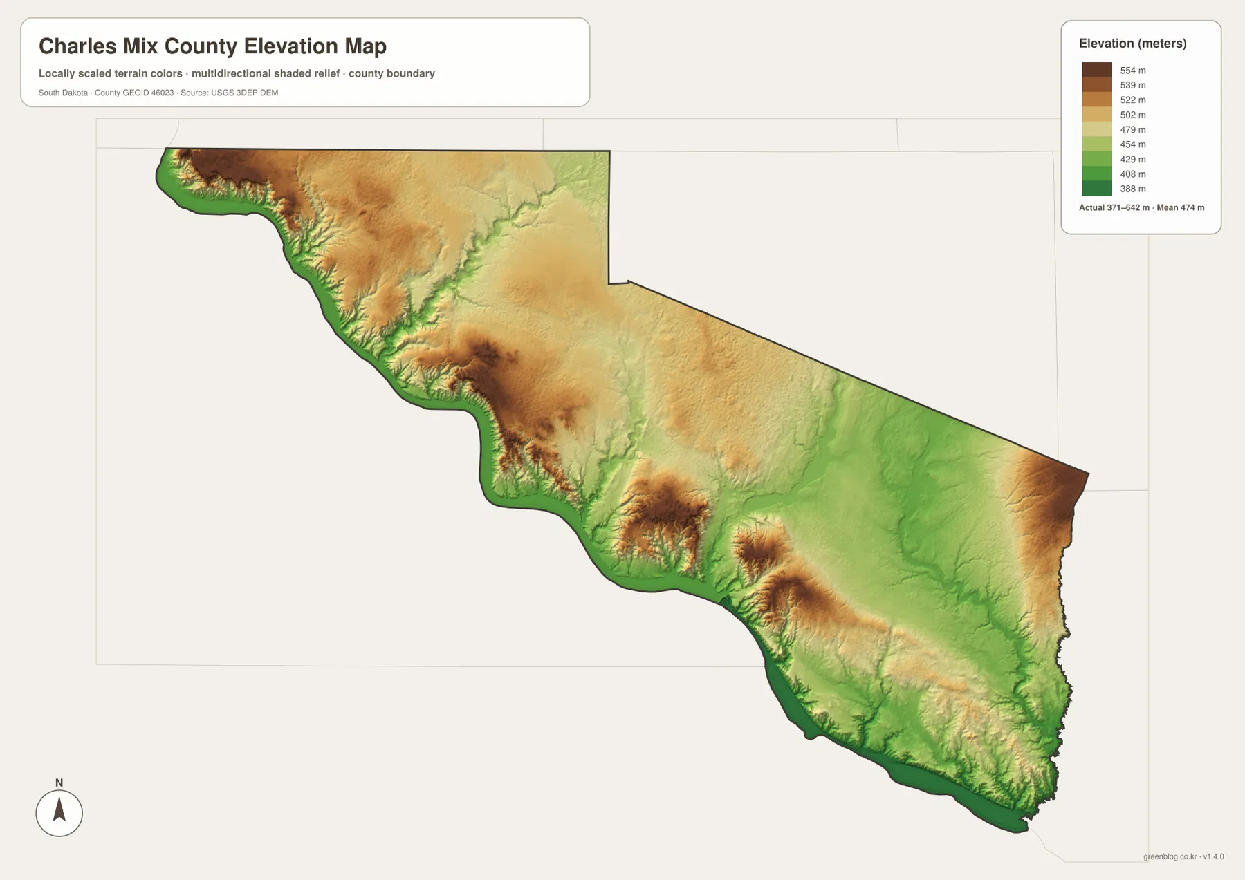
The broad central-eastern interior is generally greener than the highest western hills, but the county does not follow a simple west-high, east-low rule. Higher colors return near portions of the northeastern edge, and smaller elevated areas appear in the southeast as well. A better description is that the low river corridor is bordered by repeated uplands, with wider gentler terrain extending through much of the center and east.
Pickstown provides a useful place-based example because it is close to the Missouri River, where the elevation colors are low. Lake Andes and Wagner sit farther inland in the central-eastern area, away from the strongest western brown zones. Comparing these locations across the general and elevation maps helps explain why the county looks much more varied than a flat outline alone suggests.
The elevation image is suitable for county-scale comparison, not survey or engineering measurement. The 371–642 meter range is the actual range printed on the supplied image, but the color surface is generalized. A precise elevation for a parcel, building, road point, or construction project should be checked with detailed USGS 3DEP data or a professional survey.
Following one place across the views makes the long county easier to remember
Lake Andes is a good example. On the city-index image it is the third-ranked labeled community and sits near the south-central interior. The water map places Lake Andes beside the named lake and near Goose Lake, while the elevation view shows this area outside the strongest western uplands. That combination gives the place more meaning than simply reading its name in a list.
Pickstown works differently because the river is the strongest reference. Its city-index position is close to the Missouri River boundary, and the general map places it near the central-southern river corridor. Platte is best remembered through the northwest road network, while Wagner is a strong eastern reference near the US 18 and SD 46 area. Using each town with the feature closest to it makes the county easier to understand without repeating the same explanation.
For roads and community names, begin with the general county map. Use the city index to compare the six labeled places, the terrain-and-water view for the Missouri River, bays, lakes, and creeks, and the elevation view for the 371–642 meter relief range. The ZIP below contains the same set as original high-resolution JPG files for printing, classroom use, presentations, and closer inspection. Legal boundaries, parcel questions, live travel conditions, current water levels, flood decisions, and survey-grade elevation require current authoritative data.
Frequently Asked Questions
Are the numbers 1,529, 1,161, and 901 in the city index current population estimates?
They should not be treated that way without a separate check. This article reports Wagner 1,529, Platte 1,161, Lake Andes 901, and the other figures only as values printed in the supplied CITY INDEX. Use the latest U.S. Census Bureau data if current population is important.
Can I see Whetstone Bay, Odenbach Bay, and Joe Days Bay on the same map?
Yes. The terrain-and-water view labels all three along the Missouri River and also shows Snake Creek, Platte Creek, Pease Creek, Spring Creek, Choteau Creek, Slaughter Creek, Lake Andes, and White Lake. It does not show current river stage or flood conditions.
Can the 371–642 meter elevation range be used for a specific property?
No. The range is useful for comparing high and low parts of Charles Mix County at a broad scale. A location-specific elevation should be checked with detailed USGS 3DEP data or professional survey information.
Map File Information
The Charles Mix County general, city-index, terrain-and-water, and elevation views are packaged as high-resolution JPG files.
- Included Files: Use only the versions confirmed in the article and supplied images
- File Type: Use the confirmed download contents
- Intended Use: Printing, education, presentations, and map-based projects
Related Maps
Sources and References
The article is based first on the names, roads, water features, and elevation values visible in the supplied Charles Mix County maps. These official sources provide additional county, statistics, boundary, hydrography, and elevation reference information.
- Charles Mix County official website
- U.S. Census Bureau QuickFacts – Charles Mix County
- U.S. Census Bureau TIGER/Line Shapefiles
- USGS National Hydrography
- USGS 3D Elevation Program
Green Map creates custom-edited map images using open geographic data sources such as geoBoundaries, Natural Earth, OpenStreetMap, and government open data.
These maps are edited visual materials, not raw data files, and are provided for education, documents, presentations, and graphic reference.