La Paz County sits in western Arizona where the Colorado River edge meets a broad desert interior. Parker, the county seat, is near the river in the northwest, while Quartzsite is farther south on Interstate 10. Smaller communities such as Bouse, Brenda, Salome, Wenden, Ehrenberg, and Cibola are spread across long stretches of desert rather than forming one continuous urban area. This page uses the supplied maps to explain those locations, the main road corridors, named washes and rivers, and the county’s sharp elevation differences. A3 JPG map files are available together in the download box near the end of the article.
The county outline is part of what makes the area easy to misread on a small statewide map. The western boundary bends along the Colorado River, the eastern half widens considerably, and the southern portion narrows again. Parker and Quartzsite are therefore useful reference points, but neither city by itself explains the whole county. The general map is best for settlements and roads, the city index gives a simpler view of the two ranked major cities, and the water and elevation maps show why travel routes cross a landscape of washes, low desert, and isolated mountain ranges.
Table of Contents
Parker and Quartzsite anchor different parts of the county
Parker is shown near the northwestern side of La Paz County close to the Colorado River, with the La Paz County Courthouse marked nearby on the general map. Quartzsite lies well to the south around the I-10 and US 95 corridor. The separation is important: these are not neighboring centers in one compact urban belt. A large area of desert and low mountain terrain lies between them, and the roads that connect the county follow a few distinct corridors rather than a dense street network.
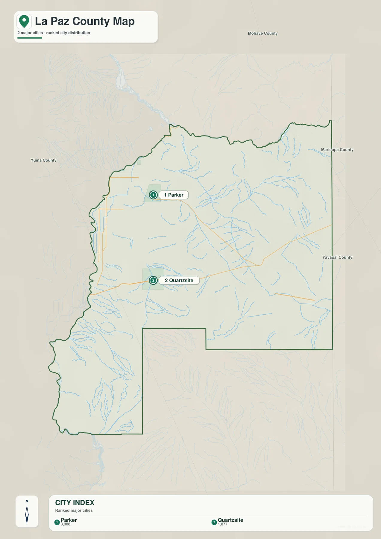
The city index map reduces the county to two ranked major cities: Parker and Quartzsite. The printed index values are 3,388 for Parker and 1,877 for Quartzsite. Those numbers should be treated as the values used by this map’s city index rather than as a claim about the latest population estimate. The useful point for map reading is positional. Parker anchors the river side of the county, while Quartzsite anchors the southern I-10 corridor.
Several smaller places fill in the space between those two anchors. AZ 72 runs east from Parker toward Bouse. Farther southeast, Vicksburg, Salome, and Wenden help define the interior of the county. Along I-10, Quartzsite connects east toward Brenda and the Salome area, while Ehrenberg sits at the western edge near the interstate crossing. Cibola is much farther south near the river. Taken together, these locations show a county made up of separated river, highway, and desert communities rather than one dominant metropolitan cluster.
The Colorado River edge contrasts with the I-10 desert corridor
La Paz County’s western edge is visually different from most of its other boundaries because it follows the irregular Colorado River side of the county. Parker, Ehrenberg, and Cibola all appear on or near this western zone. The eastern boundary, by comparison, is much straighter. This general map is intended to show county-scale geography, roads, places, and nearby features; it should not be used as a parcel map or as a legal survey of the river boundary.
I-10 is the strongest east-west transportation line in the southern part of the map. It enters near Ehrenberg, passes Quartzsite, then continues east past Brenda toward the county’s eastern side. US 95 provides the main north-south reference around Quartzsite, while AZ 72 connects the Parker area eastward toward Bouse. These three routes make the county much easier to understand. Instead of imagining all settlements as evenly distributed, it is more accurate to see Parker on a river-oriented corridor and Quartzsite on a major interstate corridor, with smaller communities occupying the long desert space between and beyond them.
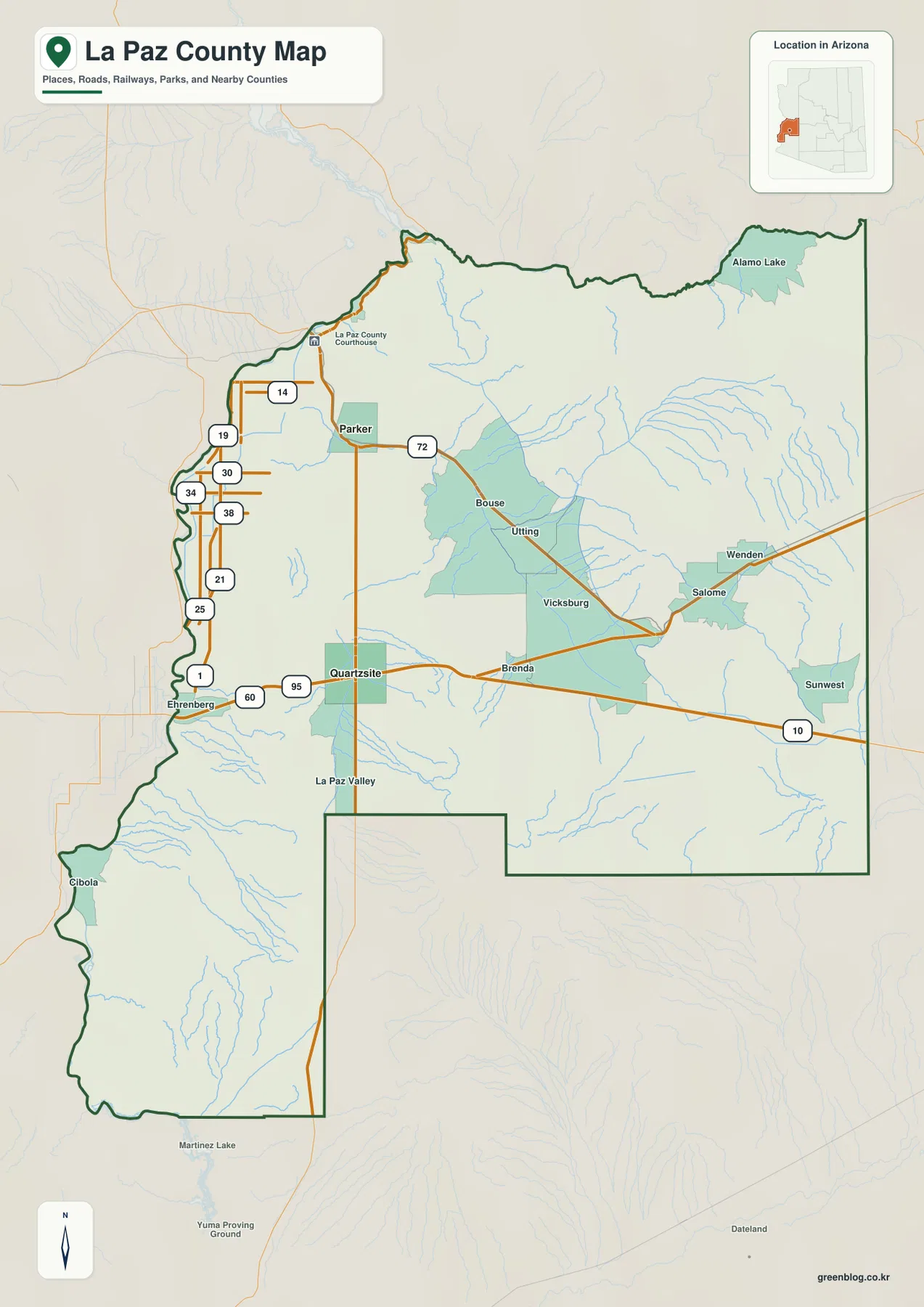
The northeastern corner adds another useful landmark: Alamo Lake is labeled near the top of the general map. Salome and Wenden help orient the eastern interior, while Bouse and Vicksburg are useful midway references between the larger Parker and Quartzsite areas. Cibola, by contrast, sits in the long southern extension near the river and is easy to overlook on a small map. A county-scale map is valuable here precisely because the distances between recognizable place names are large.
Bill Williams River and desert washes shape the drainage pattern
The terrain-and-water map contains many more named drainage features than the dry desert setting might suggest. Bill Williams River is prominent in the northeast. Bouse Wash crosses the central part of the county, Cunningham Wash appears farther east, and Centennial Wash drains a broad eastern area. In the south, Tysons Wash, French Creek, Martinez Wash, Gould Wash, McAllister Wash, and Indian Wash are among the labeled features. These names should not all be interpreted as continuously flowing rivers.
In arid Arizona, a wash is commonly a normally dry channel or drainage route that carries water during storms or after runoff reaches it. That distinction matters when using this map. It is useful for identifying named drainage lines and seeing how valleys fit between mountain areas, but it is not a flood-zone map, a navigation chart, a real-time streamflow product, or a legal water-boundary document. For a general reader, the most useful comparison is between the larger Bill Williams River system and the many washes that spread through the desert interior.
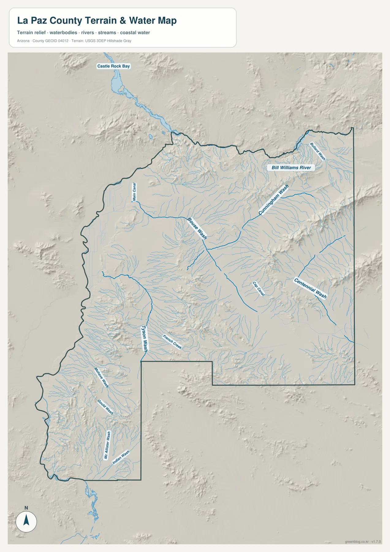
Castle Rock Bay is labeled beyond the northwestern side of the county, while the western county edge lies along the Colorado River region. Inside La Paz County, many smaller channels run out of mountain areas toward lower desert basins. Reading the water map beside the road map helps explain why roads do not form a regular grid across the entire county. Bouse, Salome, Wenden, and other interior places occupy terrain where drainage channels and isolated ridges repeatedly interrupt the open desert.
Elevation rises from the river lowlands to eastern mountain ranges
The elevation map reports an actual county range of roughly 58 to 1,715 meters, with a mean elevation of about 413 meters. The western river side appears as the broadest low-elevation zone. Higher terrain becomes more obvious toward the east and northeast, where long brown and tan ridges cross the map. Smaller mountain blocks also interrupt the central and southern desert, so the county is not simply a flat plain sloping away from the Colorado River.
This contrast is especially useful when the elevation map is compared with the water map. Washes frequently occupy the lower gaps between ridges, while the highest terrain stands out as elongated mountain bands. Parker and the river corridor are relatively low, and Quartzsite is also in the lower western half, but the route eastward crosses increasingly broken terrain. The result is a county where relatively low communities and highways are surrounded by mountains that rise sharply from the desert floor.
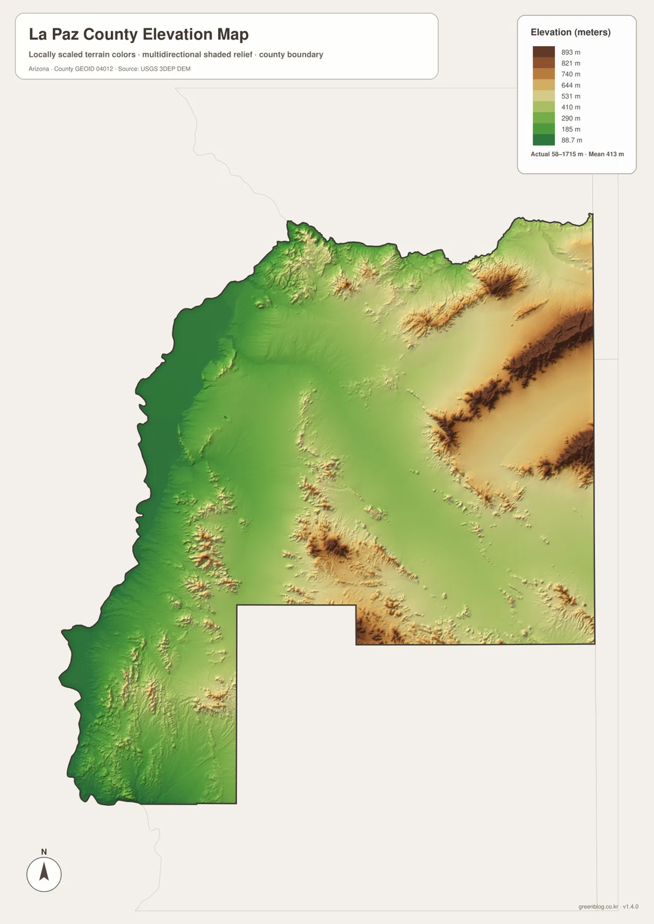
The elevation surface is best used for county-scale comparison. It can show where terrain is generally low or high, but it is not survey-grade elevation for a parcel, building site, road design, or engineering project. The supplied map is based on USGS 3DEP elevation data and generalized for a readable county view. For ordinary map use, that level of detail is enough to explain why settlement, roads, and drainage features occupy particular corridors without implying precision the map was not designed to provide.
Choose the map that matches the question
The general county map is the most useful starting point when you need Parker, Quartzsite, Bouse, Salome, Wenden, Ehrenberg, Cibola, and the major roads on one page. The city index is intentionally simpler and works well when Parker and Quartzsite are the only locations you need to compare. For drainage and terrain questions, the terrain-and-water map adds the Bill Williams River and named washes. The elevation map is the better choice when the main question is how the low river side compares with the mountain ranges farther east.
The downloadable files are also suited to different presentation needs. A classroom or general county overview usually benefits from the general map. A short slide about the county’s two major city centers may only need the city map. The water map is useful for explaining desert drainage, while the elevation map gives a fast visual explanation of relief. Using the maps separately keeps labels readable and avoids forcing roads, cities, waterways, and elevation into one overloaded image.
Frequently Asked Questions
Why do Parker and Quartzsite appear so far apart on the map?
Parker is near the Colorado River in the northwest, while Quartzsite is farther south along I-10. They belong to different transportation corridors and are separated by a large area of desert and mountain terrain. AZ 72 is a useful reference for the Parker-to-Bouse direction, while I-10 and US 95 define the Quartzsite area.
Does every wash on the water map carry water all year?
No. In this desert setting, features such as Bouse Wash, Centennial Wash, and Tysons Wash are commonly dry drainage channels that may carry runoff after storms. The map is intended to show terrain and named water features, not current flow, flood risk, or safe water crossings.
Can the elevation map be used for surveying or engineering?
No. It is a generalized county-scale elevation surface. The map reports a broad range of about 58 to 1,715 meters and a mean near 413 meters, which is useful for comparing river lowlands with eastern mountain areas. Parcel-level surveying and engineering require more detailed source data and professional measurement.
Map File Information
The download includes the La Paz County general map, city map, terrain-and-water map, and elevation map as A3 JPG files in one ZIP archive.
- Included Versions: General county, city index, terrain and water, elevation
- File Type: JPG
Related Maps
Sources and references
- La Paz County official About Us – county communities and local context
- U.S. Census Bureau TIGER/Line Shapefiles – county boundary and geographic reference data
- USGS National Hydrography – river and hydrography reference data
- USGS 3D Elevation Program – elevation source data
Green Map creates custom-edited map images using open geographic data sources such as geoBoundaries, Natural Earth, OpenStreetMap, and government open data.
These maps are edited visual materials, not raw data files, and are provided for education, documents, presentations, and graphic reference.