Cochise County stretches across a broad section of southeastern Arizona, and its map is easier to understand when roads, towns, water, and relief are viewed separately. Sierra Vista and Huachuca City sit close together in the southwest, Benson lies farther north, and Willcox stands apart in the northern part of the county. Bisbee and Douglas occupy the south, while smaller places and long road segments are scattered across the interior. This page explains those relationships first, then provides the matching high-resolution JPG files for download.
The general county map is the best starting point because it combines the county boundary, major roads, and a wider selection of place names. The city map strips away much of that detail and highlights six major cities, making their relative positions easy to compare. The terrain-and-water map shifts attention to the San Pedro River, lakes, and named creeks, while the elevation map shows how broad basins are interrupted by rugged mountain groups. Using the four views for different questions keeps the page readable and prevents one image from becoming overloaded.
The locator inset places Cochise County in the southeastern corner of Arizona. The surrounding labels show Pima County and Santa Cruz County to the west, with Graham County and Greenlee County to the north. The maps on this page are regional reference maps rather than legal boundary surveys, flood products, or turn-by-turn navigation tools. They are most useful for seeing where communities and natural features lie in relation to one another across a large county.
Table of Contents
I-10 connects Benson and Willcox across the northwest
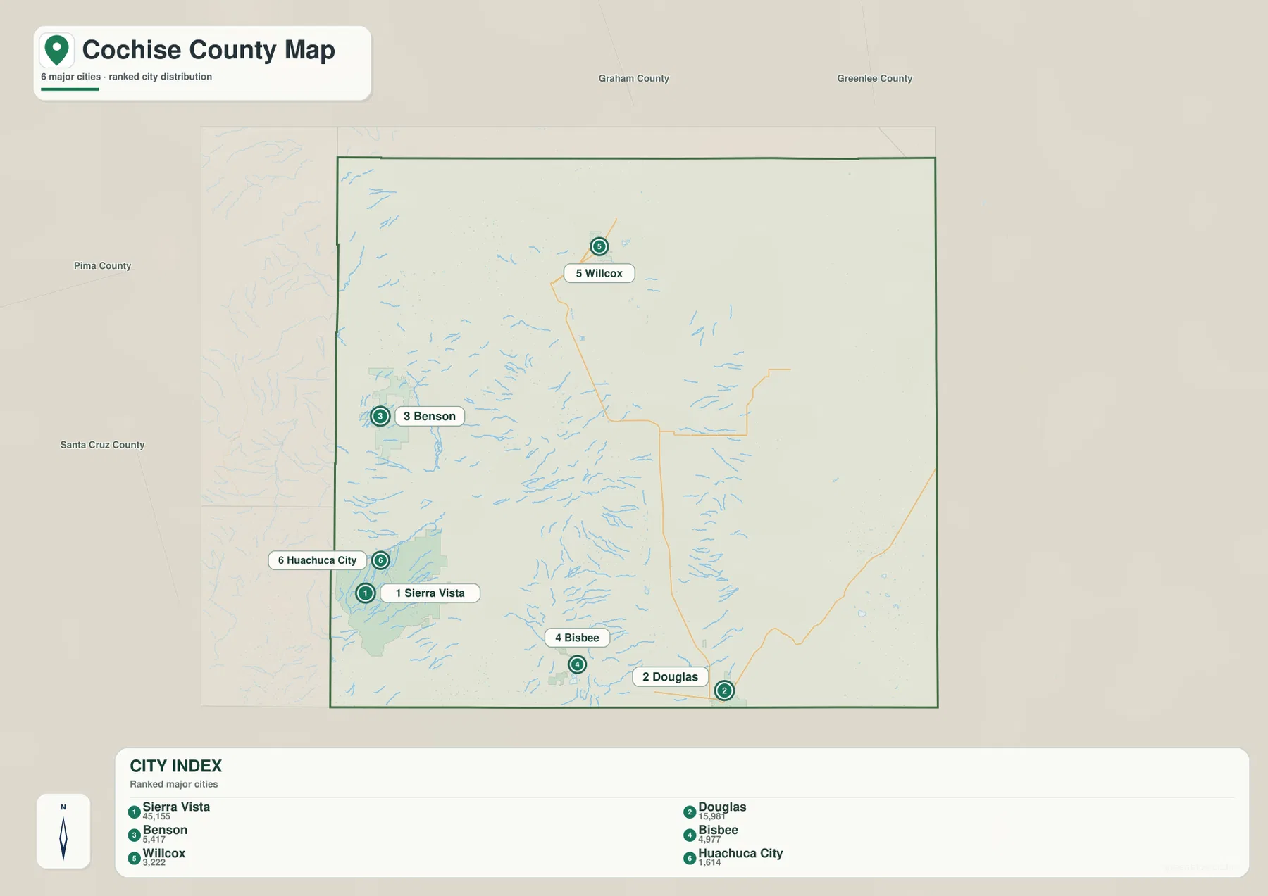
Benson is one of the clearest orientation points on the general map. The I-10 shield appears next to the city, and the highway continues northeast toward Willcox. St. David is shown just southeast of Benson, while Whetstone lies farther south. Compared with the open interior of the county, this western side contains a relatively close sequence of road labels and communities, so it is a practical place to begin reading the map.
Willcox forms a second road reference point in the north. Routes 191 and 186 are labeled around the city, and Route 181 extends southeast toward the Sunizona area. A reader trying to locate the northern part of Cochise County can therefore follow I-10 from Benson to Willcox and then use those numbered roads to move into the surrounding interior. The map does not show every local street or junction, so the route numbers are best treated as broad orientation markers rather than driving instructions.
Farther south, Route 90 is marked near Sierra Vista, Route 82 appears near Whetstone, and Route 92 is visible by Bisbee. Douglas is associated with Route 80 near the southern edge of the map. These roads help connect the named places visually, but the large gaps between them are just as important. Cochise County contains extensive open areas where towns are widely separated, particularly through the central and eastern portions.
Sierra Vista, Douglas, and the spread of major cities
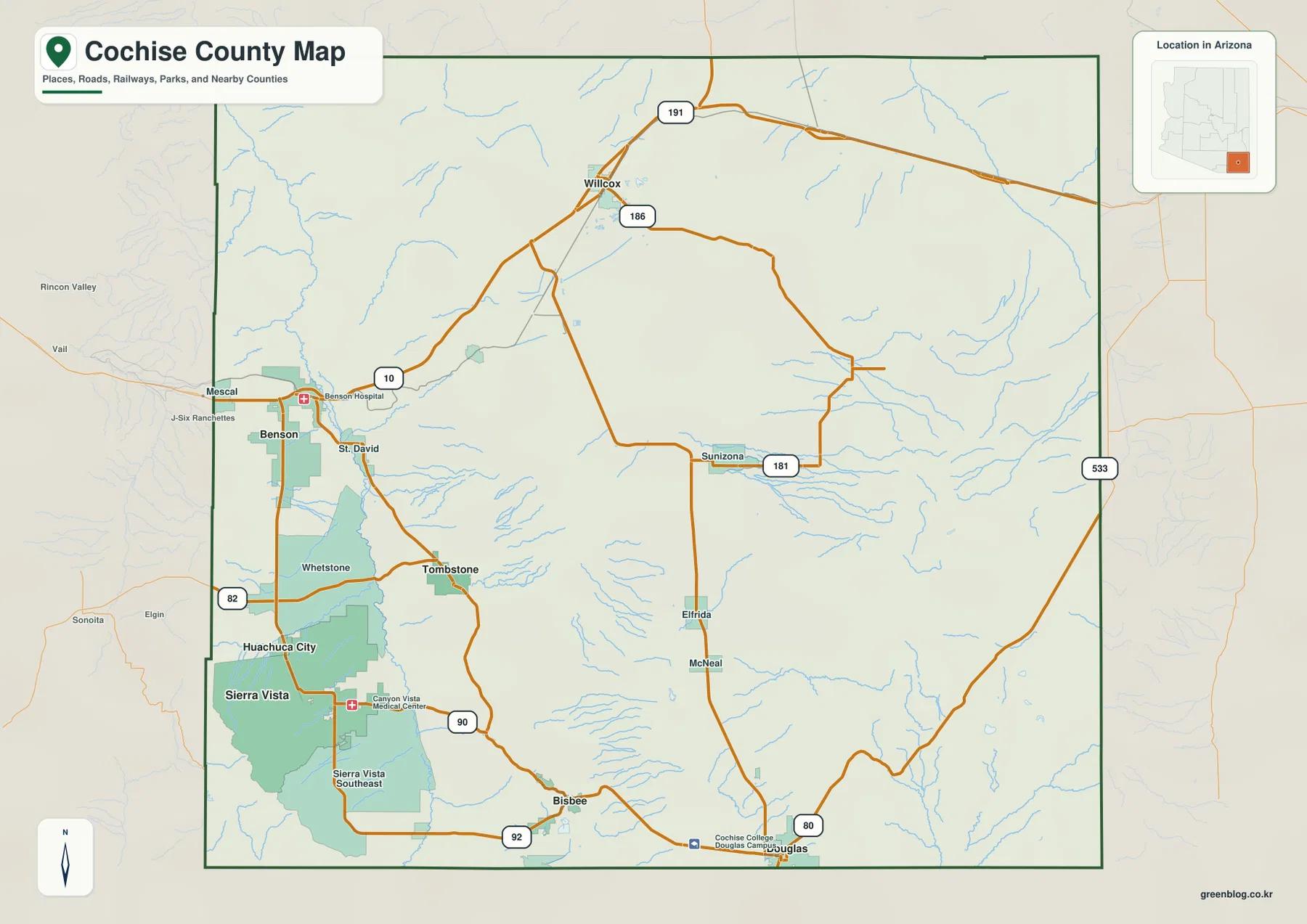
The city map makes the county’s dispersed settlement pattern especially clear. Sierra Vista and Huachuca City form a close pair in the southwest, but Benson sits well to the north. Willcox is isolated in the northern part of the county, while Bisbee and Douglas occupy different positions along the south. With only six ranked cities emphasized, the map removes most secondary labels and makes the overall layout easier to understand at a glance.
Sierra Vista is labeled as number 1 and Douglas as number 2. Benson, Bisbee, Willcox, and Huachuca City follow in the city index. The ranking is less important here than the geography. The largest communities do not form one compact cluster, and even the two southern cities are separated by a noticeable distance. Benson and Willcox also belong to different parts of the northwestern and northern road network rather than a single continuous urban strip.
For smaller communities, the general county map remains more useful. Tombstone, St. David, Whetstone, Elfrida, McNeal, and Sunizona are easier to locate there because the road framework and additional place names remain visible. The city map works best for a simplified comparison, while the county map provides the context needed to place those major cities among smaller settlements. Switching between the two views shows how widely communities are distributed across Cochise County.
The San Pedro River gives the west a clear water landmark
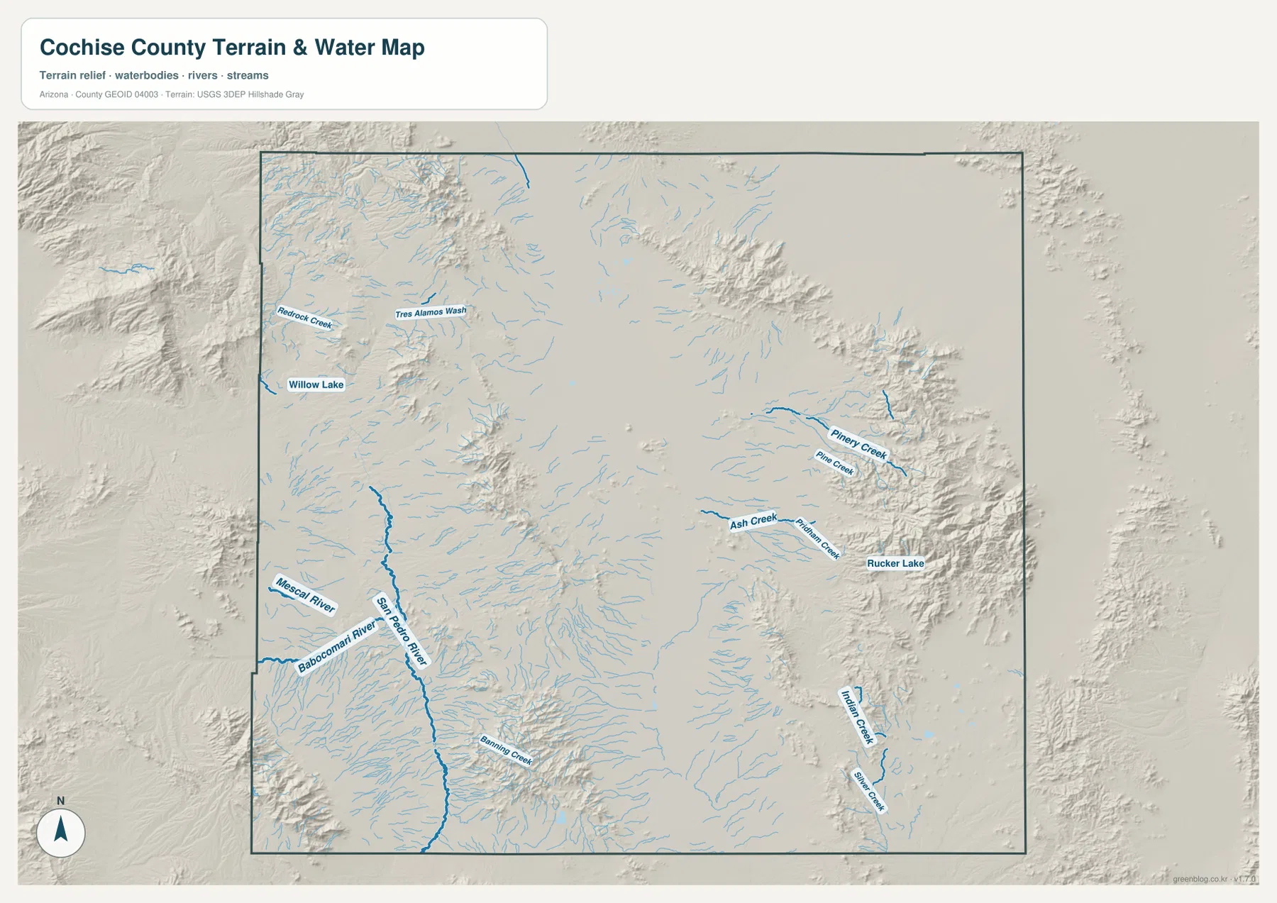
On the terrain-and-water map, the San Pedro River is the strongest continuous water feature in the county. It runs north-south through the western-central area and stands out from the many shorter blue lines nearby. Babocomari River and Mescal River are labeled near the western side, giving the San Pedro system additional reference points. This is a very different view of the same area that the general map presents through roads and communities.
Willow Lake appears in the northwest, with Redrock Creek and Tres Alamos Wash labeled nearby. Banning Creek is visible farther south. The shaded relief underneath the water lines makes it easier to see how streams occupy lower ground between rougher uplands. The blue lines should not be interpreted as proof of year-round flow, however. The map is designed to show the location of mapped water features and terrain, not current discharge, water depth, flood risk, or access conditions.
The contrast between the highway network and the river network is useful. I-10 heads northeast from Benson toward Willcox, while the San Pedro River runs for a long distance in a north-south direction through the western-central part of the county. Looking at only the road map makes transportation the dominant feature. Looking at the water map instead emphasizes valleys, drainage lines, and the landforms around them. Using both is helpful when explaining the broad setting between Sierra Vista and Benson.
Rucker Lake and short eastern creeks beside rugged ground
The eastern side of the water map has a noticeably different pattern. Rucker Lake is labeled near rugged terrain, with Ash Creek and Rattlesnake Creek nearby. Piney Creek and Pine Creek appear a little farther north. Instead of one long river dominating the view, several shorter named streams extend away from the mountain slopes. That difference makes the east easy to distinguish from the San Pedro River area even before the road or city maps are consulted.
Indian Creek and Silver Creek are also labeled in the southeastern portion of the map. The shaded surface around them is much rougher than the broad central basin, which helps explain why the waterways appear in shorter, branching forms. The purpose of this view is geographic comparison rather than hydrologic forecasting. A mapped creek line shows where a water feature is represented in the source data, but it does not state whether water is flowing at a particular time or whether a road crossing is passable.
Rucker Lake and Willow Lake also serve different orientation roles. Willow Lake helps locate the northwestern water features closer to the western drainage network, while Rucker Lake is a useful landmark for the mountainous east. Neither lake is meant to replace a detailed recreation or access map. On this page, their value comes from helping divide a very large county into recognizable natural sections.
Broad basins are broken by high mountain groups
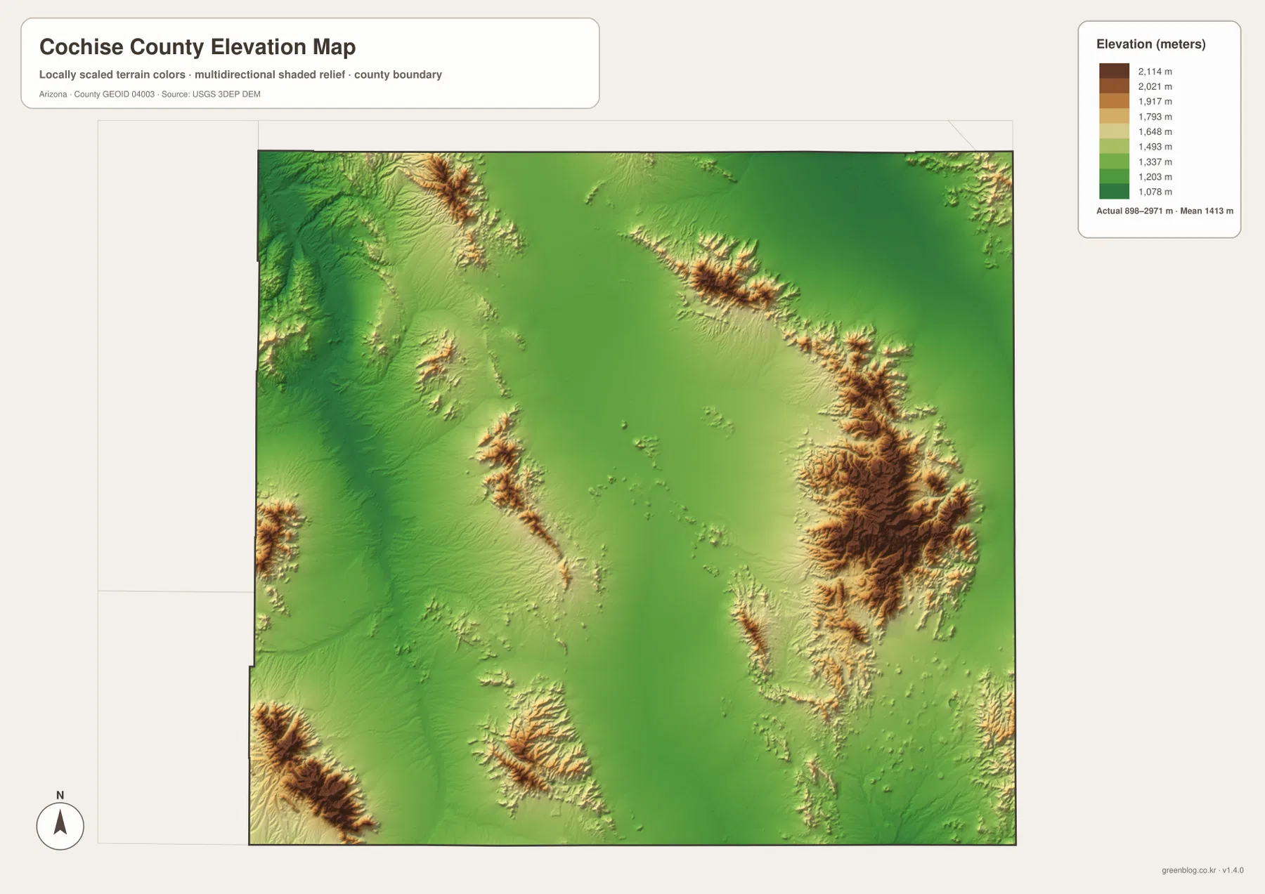
The elevation map makes Cochise County’s relief more obvious than any of the other views. Much of the broad interior and northern area appears in green tones, while higher mountain groups shift through yellow and brown. The strongest high-relief areas are visible in the east and southwest, with additional ridges interrupting the central basins. The county is therefore not a simple surface that rises steadily in one direction; it is a repeating pattern of lower basins and separate mountain blocks.
The color legend is labeled from about 1,078 meters to 2,114 meters, while the map also notes an actual overall range of roughly 898 to 2,971 meters and a mean near 1,413 meters. Those numbers provide useful context for the size of the elevation difference across the county. They are not parcel-level measurements. The map is appropriate for regional comparison, but an exact road, building site, or survey point should be checked with the original USGS elevation data or a professional survey source.
The eastern high terrain corresponds with the same area where Rucker Lake and several short creeks appear on the water map. Rugged ground also rises in the southwest near the Sierra Vista and Bisbee side of the county. Between these areas are much broader, lower surfaces. This combination of separated mountain groups and open basins helps explain why settlements, roads, and waterways can look widely spaced even when they belong to the same county.
Choosing a map for roads, cities, water, or relief
For general orientation, begin with the county map. It places Sierra Vista, Benson, Willcox, Tombstone, Bisbee, Douglas, Elfrida, McNeal, Sunizona, and several road shields in one frame. That makes it useful when the question is simply where a community sits within Cochise County. If the goal is to compare only the main cities, the city map is quicker because it removes most secondary labels and emphasizes six ranked communities.
For natural features, the water and elevation maps work especially well together. The water map shows the long San Pedro River in the west, Willow Lake in the northwest, and Rucker Lake with shorter creeks in the east. The elevation map then explains the broad contrast between lower basins and rugged mountain groups around many of those water features. A reader can move back to the general map afterward to see which roads and communities lie closest to the same areas.
The WebP images in the article are sized for fast viewing in a browser. The download archive contains the matching high-resolution A3 JPG files for the general county map, city map, terrain-and-water map, and elevation map. They are suitable for printing, classroom material, presentations, and document layouts. They remain general geographic reference maps and should not be used as legal boundary determinations, flood maps, navigation charts, or survey-grade elevation products.
Frequently Asked Questions
Which map is best for comparing Sierra Vista and Douglas?
The city map is the quickest choice when you only need their relative positions. Sierra Vista is emphasized in the southwest and Douglas is shown along the southern edge farther east. If you also need Tombstone, Elfrida, road numbers, or smaller communities, use the general county map instead.
How does the San Pedro River differ from the creeks in eastern Cochise County?
The San Pedro River appears as a long north-south watercourse through the western-central part of the county. Near Rucker Lake in the east, the map instead shows shorter streams such as Ash Creek, Rattlesnake Creek, Piney Creek, and Pine Creek beside rugged terrain. The west is therefore easier to orient around one long river, while the east is better understood through a lake, several shorter creeks, and the surrounding mountains.
Can the elevation map provide an exact elevation for a road or property?
No. The map is designed to compare broad higher and lower areas across Cochise County. The legend and overall range provide regional context, but an exact parcel, road, building site, or engineering measurement should be checked with the original USGS elevation data or a professional survey source.
Map File Information
The download ZIP contains high-resolution A3 JPG versions of the Cochise County general map, city map, terrain-and-water map, and elevation map shown on this page.
- Included Versions: general county, city, terrain and water, elevation
- File Type: JPG
Related Maps
Sources and references
For county background, see the official Cochise County website. An official reference for the mountain environment in the eastern part of the county is the National Park Service page for Chiricahua National Monument. Mapping references include U.S. Census Bureau TIGER/Line Shapefiles, USGS National Hydrography, and the USGS 3D Elevation Program. The descriptions of communities, roads, water features, and relief in this article are based primarily on the supplied Cochise County map images.
Green Map creates custom-edited map images using open geographic data sources such as geoBoundaries, Natural Earth, OpenStreetMap, and government open data.
These maps are edited visual materials, not raw data files, and are provided for education, documents, presentations, and graphic reference.