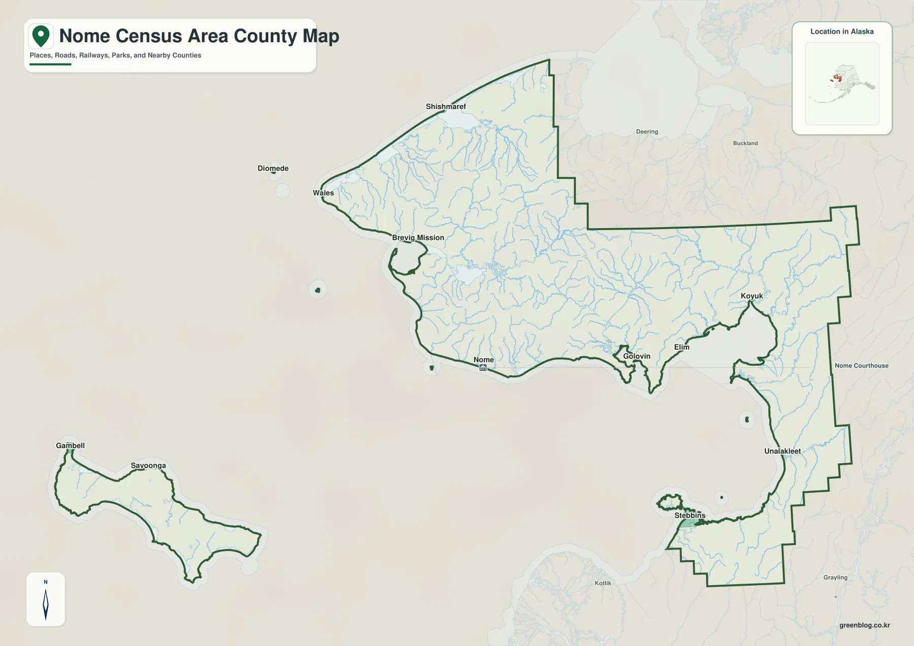
Nome Census Area is difficult to understand as a single compact block because the supplied maps show communities spread across a long western Alaska coastline and a separate island section. Nome sits on the southern coast of the main land area. Brevig Mission and Wales are farther west, Shishmaref is on the northern side, and Golovin, Elim, and Koyuk continue along the eastern coast. Unalakleet and Stebbins are farther southeast, while Gambell and Savoonga appear together in the detached island area. This article follows the places, waterways, terrain, and boundary information visible in the supplied maps, and the matching high-resolution JPG map files are available for download in the ZIP box below.
A practical way to read the map is to use Nome as the first anchor, then work outward. The western edge leads toward Brevig Mission and Wales, the north toward Shishmaref, and the eastern coast toward Golovin, Elim, Koyuk, Unalakleet, and Stebbins. Gambell and Savoonga form a separate visual section away from the main land area. The terrain-and-water map adds a second layer of information by labeling the Agiapuk, Kuzitrin, Fish, Tubutulik, Koyuk, and Unalakleet rivers, along with Norton Sound and many smaller channels. Together, the maps show a census area whose settlements and waterways are distributed over a very large footprint.
Table of Contents
Nome anchors the southern coast, but the settlement labels extend far beyond it
Nome is the easiest place to find on the county map because it is labeled near the middle of the southern coast and includes a small civic-building symbol. Moving west from Nome brings Brevig Mission into view, followed by Wales near the far western end. Shishmaref appears along the northern coast. These places are not crowded into a single urban cluster; they are separated by long stretches of coastline and interior land, so the full extent of the boundary matters when reading the map.
The eastern side has its own chain of labels. Golovin sits near a small bay, Elim is farther east, and Koyuk appears beyond it. Unalakleet is positioned farther southeast along the coast, while Stebbins occupies a separate protruding section to the southwest of Unalakleet. The map also shows nearby labels outside the boundary, including Deering, Buckland, Kotlik, and Grayling. Those surrounding names help with orientation, but they should not be interpreted as places inside Nome Census Area simply because they appear on the same page.
The detached island section in the southwest contains Gambell and Savoonga. It is visually separated from the main land area by open water, which makes it one of the most distinctive features of the county map. Diomede is also labeled west of the main coast in the broader map view. Because very small offshore features are necessarily compressed at this scale, the map works best for regional orientation rather than for measuring exact shoreline geometry or legal boundaries.
The scale of the area is also clear in official Census geography statistics. U.S. Census Bureau QuickFacts for Nome Census Area lists 22,969.46 square miles of land area in 2020 and a population density of 0.4 people per square mile. Those figures help explain why the map can contain many named communities while still showing large spaces between them. For exact legal boundary coordinates, however, the Census TIGER/Line files are more appropriate than a general-reference map image.
The city index reduces the map to six widely separated reference points
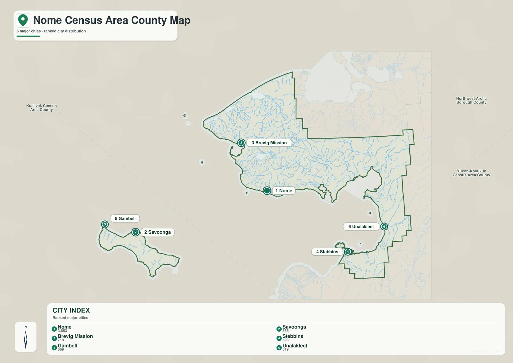
The city-index version removes many smaller labels and highlights six places with numbered markers. Nome is ranked 1, Savoonga 2, Brevig Mission 3, Stebbins 4, Gambell 5, and Unalakleet 6. The sequence is useful for quick reference, but the map itself is more informative than the ranking when the goal is geographic orientation. Nome and Brevig Mission are on the main western land area, Stebbins and Unalakleet are far to the southeast, and Savoonga and Gambell occupy the detached island section.
The CITY INDEX panel prints values of 3,653 for Nome, 866 for Savoonga, 718 for Brevig Mission, 605 for Stebbins, 569 for Gambell, and 519 for Unalakleet. These are the index values included in the supplied map and should not automatically be treated as the latest official population estimates. Current population counts can change over time, so the most recent Census release should be checked when up-to-date demographic figures matter. On this map, the six markers are most useful for comparing relative location and the very large distance between the main settlement groups.
Surrounding administrative labels add regional context. Kusilvak Census Area appears to the west and southwest, Northwest Arctic Borough is shown to the northeast, and Yukon-Koyukuk Census Area appears to the east. Their names help place Nome Census Area within western Alaska, but the city-index map is not designed to settle a legal boundary question. The outlined area and nearby labels are a visual reference for orientation.
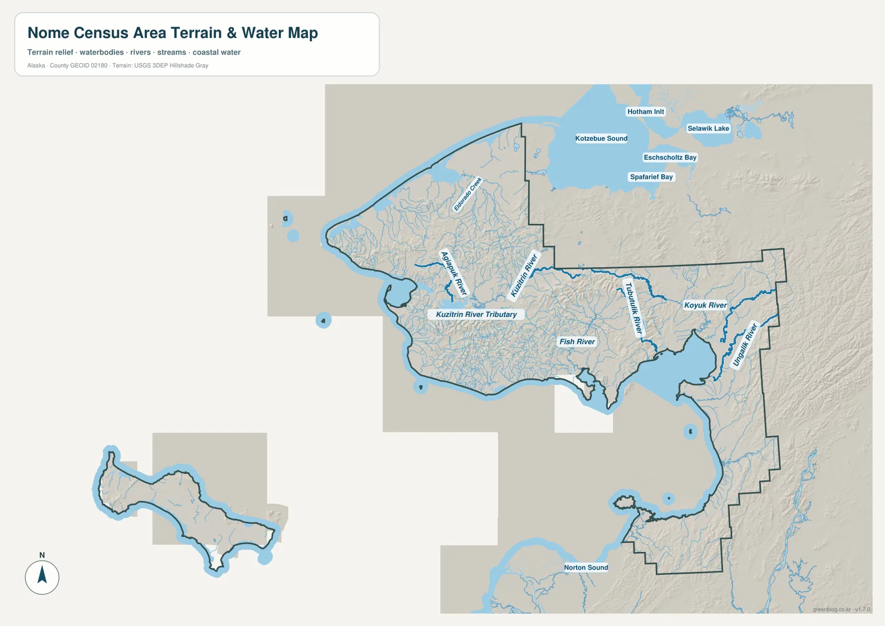
Agiapuk, Kuzitrin, Fish, Tubutulik, Koyuk, and Unalakleet rivers fill the interior
The terrain-and-water map changes the visual emphasis from settlements to drainage and relief. Eldorado Creek is labeled in the western interior. The Agiapuk River and Kuzitrin River are shown farther south and east, with a Kuzitrin River Tributary label crossing the central-western part of the map. Fish River appears in the south-central interior. These named waterways sit within a much denser network of smaller blue channels, making the interior look far less empty than it does on the general county map.
Farther east, the Tubutulik River runs toward the coast and the Koyuk River occupies the eastern side. The Unalakleet River is clearly labeled near the southeastern boundary. Because the map uses stronger blue lines for several major rivers and thinner lines for smaller streams, it is easy to compare the named waterways with the broader local drainage network. The map does not provide discharge, flood stage, navigability, or water-depth information, so it should not be used for those purposes.
Norton Sound is the large coastal water body along the southern side of the mapped area. The broader northern context also includes labels such as Kotzebue Sound, Hotham Inlet, Eschscholtz Bay, and Selawik Lake outside or beyond the main Nome Census Area outline. Those names are helpful orientation markers, not evidence that every labeled water body lies within the census area. Relief shading becomes more pronounced in parts of the eastern and interior map, but the image does not provide elevation numbers; a detailed elevation dataset is needed for precise height comparisons.
The coast, river country, and detached island section are easier to compare across all three maps
The strongest geographic contrast on the supplied maps is between the scattered coastal communities and the dense river network of the interior. Nome, Brevig Mission, Wales, and Shishmaref occupy the western and northern part of the main outline. Golovin, Elim, Koyuk, Unalakleet, and Stebbins extend the settlement pattern east and southeast. Gambell and Savoonga remain visually separate in the island section. No single cluster dominates the full map, which is why a full-boundary view is useful before looking at individual communities.
The water map adds another way to understand the spaces between those labels. Agiapuk River, Kuzitrin River, Fish River, Tubutulik River, Koyuk River, and Unalakleet River show that the interior is crossed by numerous waterways rather than being a blank area between towns. Norton Sound provides a strong southern coastal reference. When community names are the priority, the general and city-index maps are easier to read; when the relationship between rivers, coast, and relief matters, the terrain-and-water version is the better choice.
Choose the county, city-index, or water map according to the task
The county map is the most useful version for seeing the full outline and the larger set of place names together. It works well for comparing Nome with Shishmaref, Wales, Koyuk, Unalakleet, Stebbins, Gambell, and Savoonga. The city-index map is cleaner when only six major reference points are needed. The terrain-and-water map is the best option for named rivers, the Norton Sound shoreline, and broad relief. Moving among the three versions is more effective than expecting one image to provide every type of detail.
The download archive contains the larger JPG originals corresponding to the three maps used on this page. They are useful for printing, offline reference, presentations, and classroom material when a higher-resolution image is preferable to the WebP shown in the article. High resolution does not make the maps survey-grade or suitable for legal boundary determinations, flood decisions, navigation, engineering, or parcel ownership questions; official datasets should be used for those purposes.
Frequently Asked Questions
How are Nome, Savoonga, and Gambell positioned on the map?
Nome is on the southern coast of the main land area. Savoonga and Gambell are shown together in a detached island section to the southwest. The county map is best for comparing the broad placement of all three, while the city-index map makes Savoonga and Gambell easier to locate because they receive numbered markers.
Which map is best for named rivers?
The terrain-and-water map is the clearest choice. It directly labels the Agiapuk River, Kuzitrin River, Fish River, Tubutulik River, Koyuk River, and Unalakleet River and also shows many smaller streams. The general county map is useful alongside it when you need to compare those waterways with settlement locations.
What is included in the downloadable ZIP?
The ZIP contains three high-resolution JPG files matching the county map, city-index map, and terrain-and-water map on this page. They are suitable for general printing, presentations, education, and geographic reference, but they are not legal boundary surveys, flood maps, navigation charts, or engineering plans.
Map File Information
Download the Nome Census Area maps as high-resolution JPG files. The ZIP contains the county map, city-index map, and terrain-and-water map shown in this article.
- Included Files: Use only the versions confirmed in the article and supplied images
- File Type: Use the confirmed download contents
- Intended Use: Printing, education, presentations, and map-based projects
Related Maps
Sources and references
County-specific population and land-area statistics are available from U.S. Census Bureau QuickFacts for Nome Census Area. Official administrative boundary data are available from the U.S. Census Bureau TIGER/Line Shapefiles. Water-network reference data are available through USGS National Hydrography, and detailed elevation data are available from the USGS 3D Elevation Program.
Green Map creates custom-edited map images using open geographic data sources such as geoBoundaries, Natural Earth, OpenStreetMap, and government open data.
These maps are edited visual materials, not raw data files, and are provided for education, documents, presentations, and graphic reference.