Kenai Peninsula Borough covers much more than the peninsula suggested by its name. The supplied maps show a large borough divided visually by Cook Inlet, with Kenai and Soldotna clustered on the inlet’s eastern side, Homer near the southwest end of the peninsula, Seward on the mountainous eastern coast, and a broad western mainland area across the water. Nikiski, Sterling, Kalifornsky, Cohoe, Ninilchik, Happy Valley, Anchor Point, and other labels add detail between the larger communities. This article uses only features visible in the supplied maps and supporting county material, and the matching high-resolution JPG map files can be downloaded together from the file box below.
The most useful way to read the borough is to start with communities rather than trying to memorize the outline. Kenai and Soldotna form an obvious northwestern reference area, Homer anchors the long southwest side, and Seward provides a separate eastern-coast reference. The terrain-and-water map then explains why those places feel separated: Cook Inlet occupies the center of the region, mountain relief covers much of the peninsula interior and western mainland, and major waterways point toward different coasts. Seen together, the maps turn a complicated boundary into several recognizable zones that are easier to compare.
Table of Contents
Kenai and Soldotna form the clearest community cluster on the general map
On the general borough map, Kenai sits close to the eastern shore of Cook Inlet and Soldotna lies inland to the southeast. Nikiski appears farther north, while Sterling is east of Soldotna. Kalifornsky and Cohoe fill in the coast and road corridor south of Kenai. This part of the borough contains the densest concentration of named places and road lines on the supplied general map, making it a natural starting point for readers who want to orient themselves before looking at the larger peninsula.
Following the west side of the peninsula southward brings Ninilchik, Happy Valley, and Anchor Point into view before the map reaches Homer. Homer is clearly separated from the Kenai–Soldotna cluster by the long coastal stretch between them. The shoreline bends sharply around the southern peninsula, and the Seldovia Police Department marker appears across the water from Homer’s side of the map. That marker is a local reference symbol rather than one of the ranked cities on the separate city-index map, so the two products should not be read as identical lists of places.
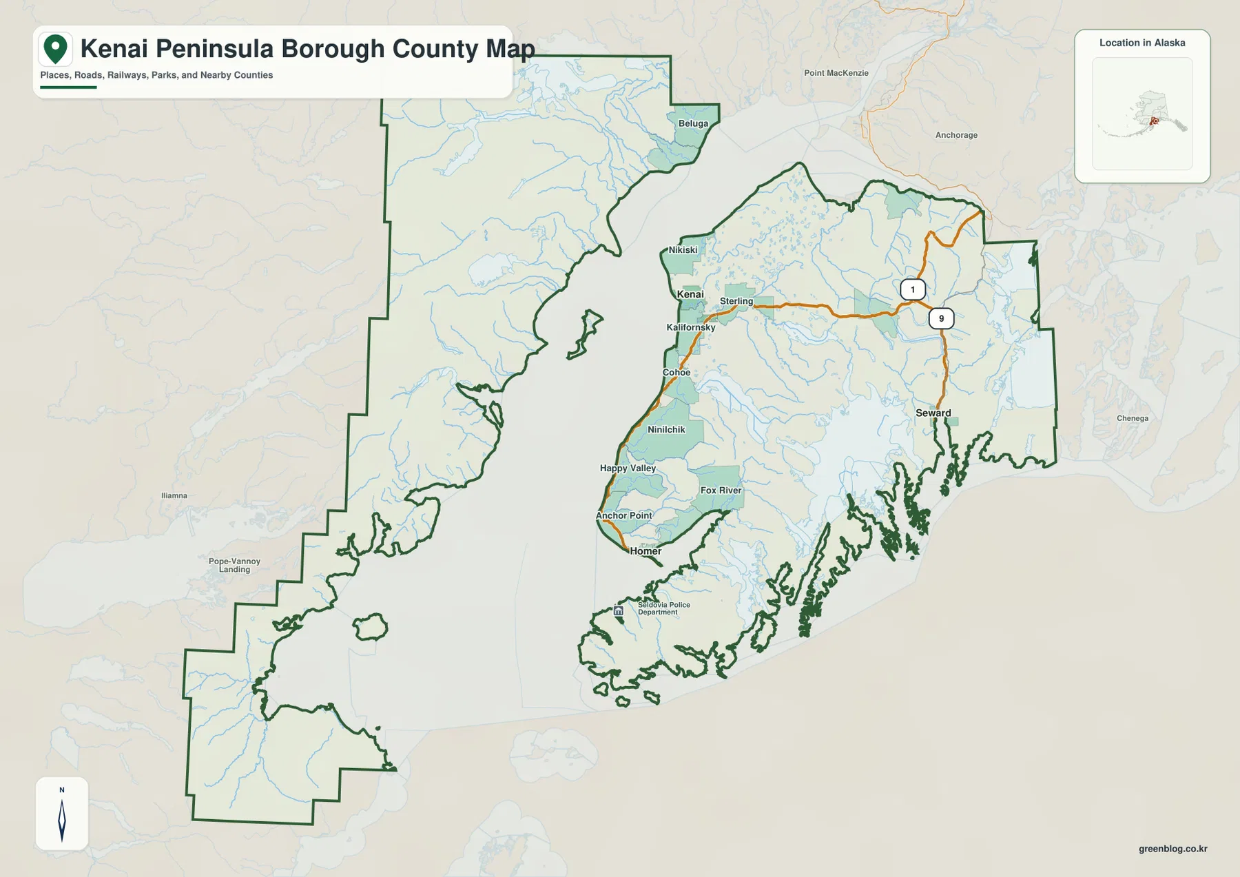
Seward occupies a different setting on the eastern side of the peninsula. It appears near Route 9, away from the long Cook Inlet community line. Route 1 is another useful road reference farther north and west, helping connect the broad interior view back toward the Kenai–Soldotna area. The map does not include live traffic, winter closures, construction, ferry status, or travel times, but it is useful for seeing which communities share a road corridor and which are separated by mountain terrain or a different coast.
Five ranked cities reveal three different parts of the borough
The city-index map ranks five places: Kenai, Homer, Soldotna, Seward, and Kachemak. The printed index shows Kenai at 7,641, Homer at 5,877, Soldotna at 4,485, Seward at 2,794, and Kachemak at 805. Those numbers should be treated as values printed on this supplied map rather than a claim that they are the latest official population estimates. Readers who need current population statistics should check the U.S. Census Bureau or another current official source.
The positions of the five places are more important for understanding the map than the ranking itself. Kenai and Soldotna sit close together in the northwest part of the peninsula. Homer and Kachemak form a second pair near the southwest end, while Seward stands alone on the east side. That arrangement creates three easy geographic reference groups: the Kenai–Soldotna area, the Homer–Kachemak area, and Seward. It also makes clear why a single “center” is not enough to describe the borough.
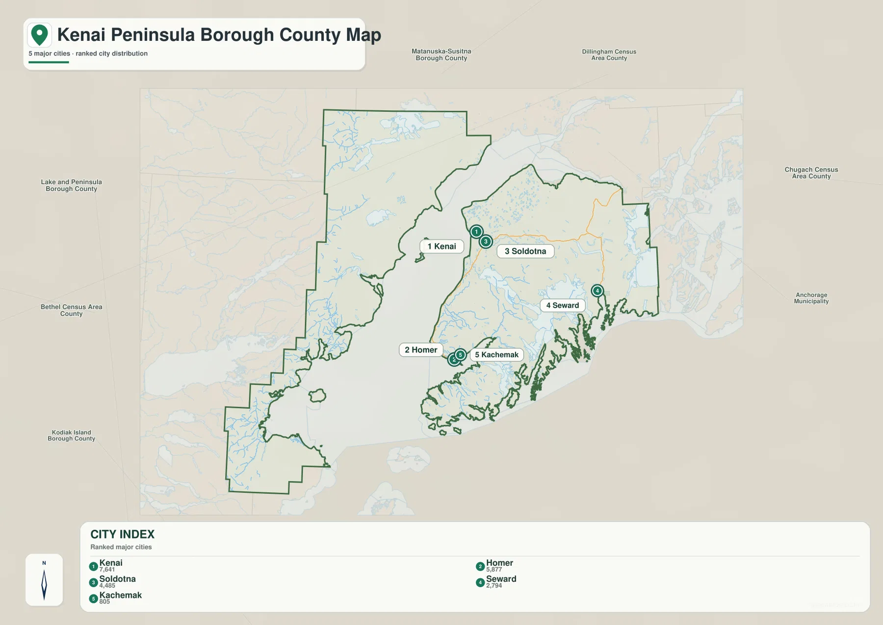
Labels outside the borough include Matanuska-Susitna Borough, Anchorage Municipality, Chugach Census Area, Dillingham Census Area, Lake and Peninsula Borough, Bethel Census Area, and Kodiak Island Borough. These surrounding names help place Kenai Peninsula Borough within Southcentral and Southwest Alaska. They should not be used as a substitute for an official boundary dataset, because the city-index map is designed for regional orientation rather than legal or survey-grade boundary work.
Cook Inlet is the dominant water feature and explains the borough’s unusual shape
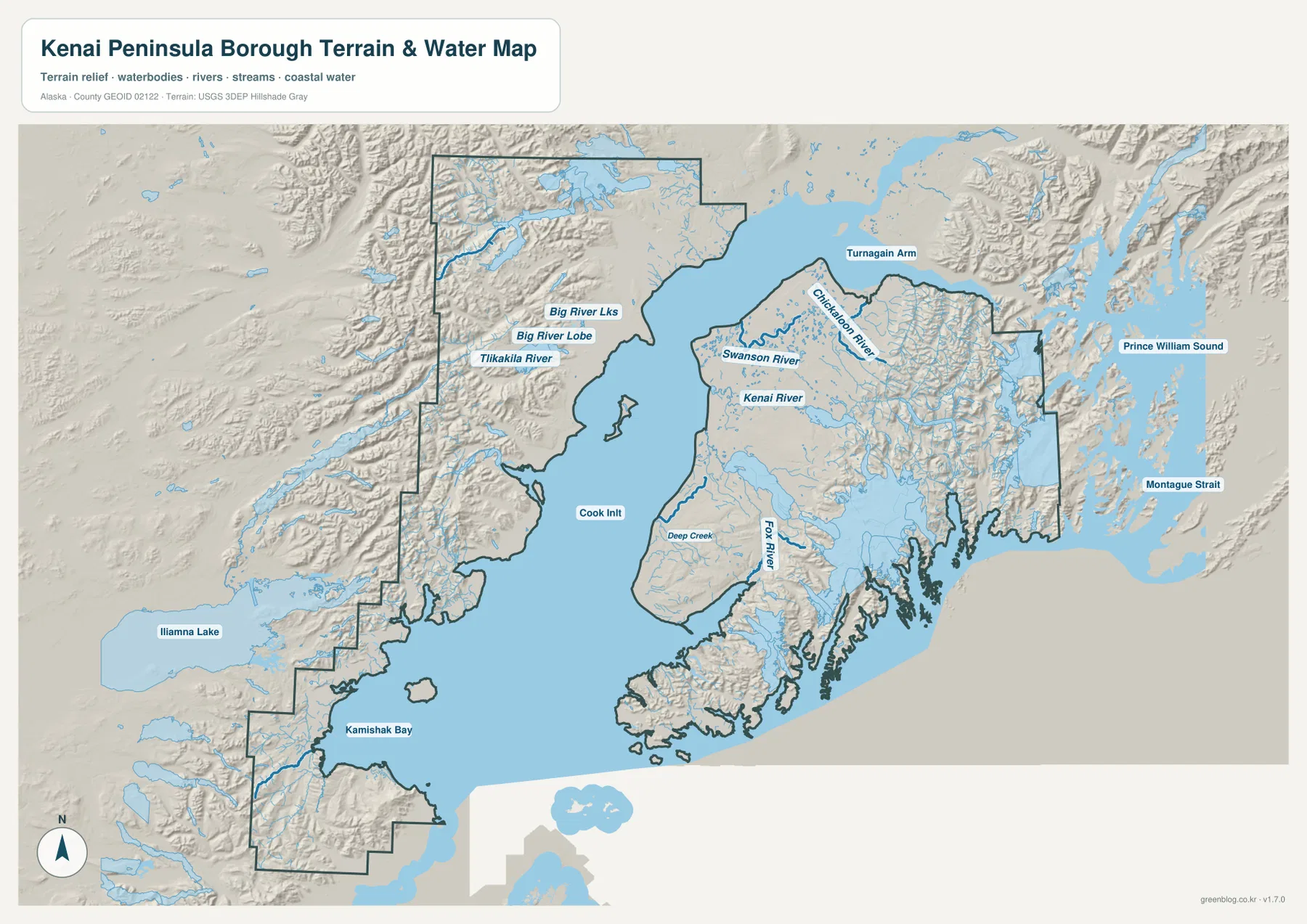
Cook Inlet occupies the center of the terrain-and-water map and separates the peninsula from a large western mainland section that is also inside the borough boundary. Turnagain Arm extends eastward from the inlet’s northern end, while Kamishak Bay appears farther south on the western side. This makes the borough look almost divided into separate landscapes even though the boundary connects them administratively. The water map is especially useful here because the general map’s large open-water area can otherwise make the western land section look like background.
The western mainland is mostly represented by relief, rivers, lakes, and sparse place labels. The map names Big River Lks, Big River Lobe, and Tlikakila River in that broader western setting, while Iliamna Lake appears beyond the borough boundary as a major regional reference to the southwest. These features show why the western portion should not be ignored when reading a Kenai Peninsula Borough map. The borough includes a significant landscape across Cook Inlet, not just the road-connected peninsula communities that are more familiar to many visitors.
Kenai River, Swanson River, and Chickaloon River divide the northern peninsula into distinct valleys
Kenai River is the most recognizable named river on the northern peninsula portion of the water map. It runs toward Cook Inlet close to the Kenai–Soldotna community area shown on the other maps. Swanson River appears farther north, among a landscape dotted with many smaller water bodies, while Chickaloon River follows a more mountainous corridor to the east. Their different positions help explain why the northern peninsula contains both relatively developed community areas and much larger stretches of wetland, river, lake, and mountain terrain.
Comparing the general and terrain maps is particularly useful around Kenai River. Roads and named communities are concentrated near Kenai and Soldotna, but the water map adds the river corridor that ties that area to the broader physical landscape. Swanson River is less connected to the urban labels, and Chickaloon River lies in rougher relief. The shaded background does not provide exact elevation values, yet it clearly distinguishes lower, more open terrain from steep mountain areas and makes the river valleys easier to see.
Fox River and Deep Creek add detail to the Homer side of the peninsula
Farther south, Fox River and Deep Creek provide two useful water references for the Homer side of the peninsula. Fox River appears closer to the southern interior and the Kachemak area, while Deep Creek is nearer the Cook Inlet side. When the general map’s sequence of Ninilchik, Happy Valley, Anchor Point, and Homer is compared with the terrain map, the southwest coast becomes more than a line of communities: it is a landscape of small watersheds, rolling or mountainous terrain, and a shoreline that becomes increasingly complex toward the peninsula’s end.
The coastline around Homer and farther south is heavily indented, with bays, narrow water passages, islands, and steep landforms appearing close together. The water layer is useful for regional orientation, but it is not a nautical chart and should not be used to judge depth, tide, current, navigability, or safe boating routes. Those questions require dedicated marine sources. Here, the value of the map is in showing how Homer sits at a transition between the long Cook Inlet shore and the more broken southern coastal terrain.
Seward faces a mountain coast connected visually to Prince William Sound
The eastern side of the map has a very different appearance. Seward lies within a deeply cut mountain-and-water landscape, and the shoreline east of the peninsula is much more irregular than the Cook Inlet side. Prince William Sound is labeled beyond the borough to the east, and Montague Strait appears farther southeast. These external water labels help orient the viewer and make Seward’s setting easier to understand: it belongs to the eastern mountain coast rather than the long western shoreline where Kenai and Homer are located.
The relief shading around Seward and the eastern peninsula is also noticeably stronger. That visual pattern is useful for distinguishing rugged mountain terrain from lower areas, but it should not be treated as survey-grade elevation or slope data. Exact heights, engineering grades, avalanche assessments, construction decisions, and other precision work require a dedicated elevation dataset such as the USGS 3D Elevation Program. The map is intended to explain relative terrain and water relationships at a regional scale.
Using the three views together separates community geography from physical geography
No single supplied image explains every part of Kenai Peninsula Borough equally well. The general map is strongest for community names, roads, and the boundary. The city index simplifies the borough into five ranked city references, making the separation between Kenai–Soldotna, Homer–Kachemak, and Seward immediately visible. The terrain-and-water map restores the physical detail that the city index removes, showing Cook Inlet, rivers, bays, mountains, and the western mainland section across the water.
A reader can therefore move from familiar places to larger natural features. Start at Kenai and Soldotna, trace the community line south to Homer, then find Seward on the opposite side of the peninsula. After that, switch to the water map and locate Kenai River, Swanson River, Fox River, Deep Creek, Cook Inlet, and the western mainland. This sequence avoids treating empty-looking mountain areas as unimportant and makes the borough’s large scale easier to appreciate.
- For places, roads, and the full outline: use the general borough map.
- For comparing the main city locations: use the city-index map for Kenai, Homer, Soldotna, Seward, and Kachemak.
- For rivers, bays, inlet geography, and mountain relief: use the terrain-and-water map.
- For precise legal, hydrographic, elevation, or engineering questions: consult the relevant official source instead of relying on these reference maps alone.
Which map works best for printing, teaching, or a quick location check?
The general map is the best first choice when the main goal is to locate Kenai, Soldotna, Homer, Seward, nearby communities, roads, and the entire borough boundary in one view. The city index is cleaner for a presentation that only needs the main urban reference points. The terrain-and-water map is better for explaining why the borough is geographically complex, especially the role of Cook Inlet, the western mainland, river valleys, and the rugged eastern coast. Choosing the map that matches the question keeps the page easier to read.
For printed or offline work, the download below contains the larger JPG originals that correspond to the three WebP maps used in the article. They can be useful for classroom handouts, presentations, personal reference, and regional orientation. Higher resolution does not make them legal surveys, flood-hazard studies, navigation charts, parcel maps, or engineering plans, so readers should use official specialized datasets whenever a decision depends on exact boundaries, elevations, water conditions, or current transportation information.
Frequently Asked Questions
Why do Kenai and Soldotna appear as the closest major-city pair?
Both the general map and the city-index map place Kenai and Soldotna close together on the northwest side of the peninsula. Sterling, Kalifornsky, and other nearby labels also occupy the same broader area. The maps do not define an official commuting or metropolitan boundary, but they clearly show that Kenai and Soldotna are geographically much closer to each other than either is to Homer or Seward.
What is the easiest way to compare Homer and Seward?
Locate Homer on the southwest Cook Inlet side of the general map and Seward on the eastern mountain coast. Then use the terrain-and-water map to see the difference in their settings. Homer is tied visually to the long Cook Inlet shoreline and the southern peninsula, while Seward sits in a much more sharply cut coastal and mountain environment toward Prince William Sound.
What files are included in the downloadable ZIP?
The archive contains three high-resolution JPG files matching the subjects shown in the article: the general borough map, the city-index map, and the terrain-and-water map. They are intended for geographic reference, printing, classroom use, and presentations. The ZIP does not contain survey plats, flood maps, nautical charts, live traffic layers, or engineering-grade terrain data.
Map File Information
The Kenai Peninsula Borough maps shown in this article are available as high-resolution JPG files. The ZIP contains the larger originals for the general map, city-index map, and terrain-and-water map.
- Included Files: 3 high-resolution JPG images
- File Type: JPG files in one ZIP archive
Related Maps
Sources and further reference
For local government information and borough mapping resources, see the Kenai Peninsula Borough official website. The borough-supported Visit the Kenai Peninsula site provides additional regional context on communities and landscapes. For official boundary data, use U.S. Census Bureau TIGER/Line Shapefiles; for official hydrography, see USGS National Hydrography; and for detailed elevation data, see the USGS 3D Elevation Program.
Green Map creates custom-edited map images using open geographic data sources such as geoBoundaries, Natural Earth, OpenStreetMap, and government open data.
These maps are edited visual materials, not raw data files, and are provided for education, documents, presentations, and graphic reference.