Ketchikan Gateway Borough is a southeastern Alaska borough where a compact community area sits beside a much larger landscape of islands, mountain valleys, rivers, inlets, and open coastal water. On the supplied general map, Ketchikan and Saxman form the clearest cluster near the southwest side of the borough. Loring and Yes Bay Historical appear farther north, while much of the eastern half contains long waterways and very few settlement labels. The matching high-resolution JPG maps used for this page are available in the download box below, so readers can use the web versions for quick reference and the larger files for printing or offline study.
The borough becomes easier to understand when it is divided into a few visual reference areas. Ketchikan and Saxman provide a community anchor. The eastern mainland is organized by major rivers such as the Unuk, Leduc, Chickamin, Blossom, Keta, and Marten. Farther west and south, the coastline breaks into islands, sounds, inlets, and passages before opening toward Dixon Entrance. Reading the maps in that order avoids treating the complicated outline as one shape that has to be memorized. Instead, each map adds a different piece of the same geography.
Table of Contents
Ketchikan and Saxman provide the easiest starting point on the borough map
The general borough map places Ketchikan and Saxman close together near the southwest coast, where road lines are more visible than in most of the rest of the borough. Route 7 is marked in the same area, creating an obvious reference point for readers who want to orient themselves before following the boundary north or east. Loring appears farther north, and Yes Bay Historical is shown in a more deeply indented coastal setting. Metlakatla is labeled outside the borough to the south, while Wrangell and Hyder appear in the surrounding map background. These surrounding names help place the borough within the broader Southeast Alaska region without implying that they are all inside the borough boundary.
The boundary also shows why the borough should not be imagined as only the urban area around Ketchikan. From the southwest islands and narrow coastal sections, it extends into a broad eastern mainland crossed by many streams and mountain valleys. Long water corridors cut deeply between land sections, and the shoreline repeatedly bends around islands, peninsulas, and inlets. The contrast between the small road-and-community cluster and the much larger natural area is one of the clearest features visible on the supplied map.
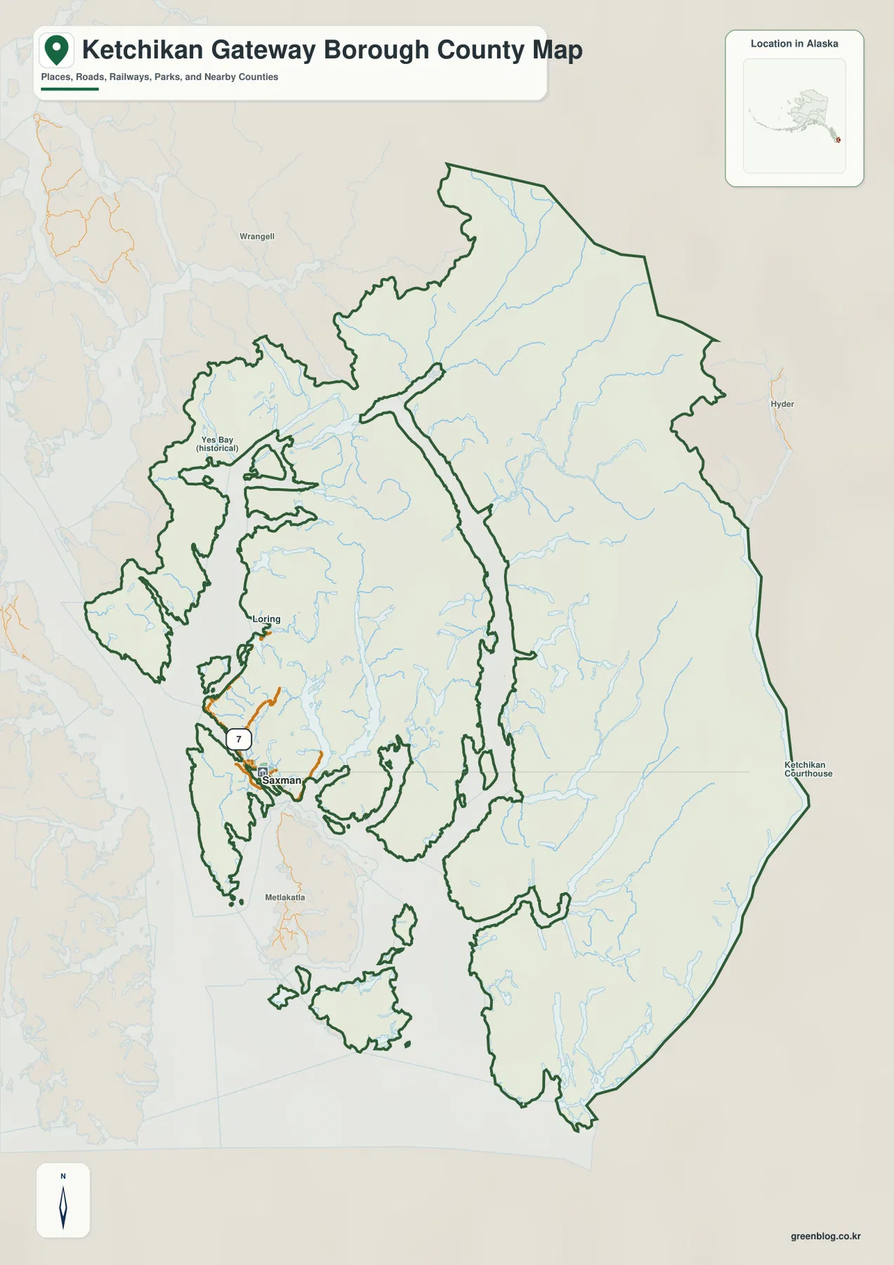
The general map is especially useful for orientation because it combines settlements, roads, water lines, and the administrative outline in one view. It is not a survey plat or a legal boundary record, so readers who need exact coordinates should use an official boundary dataset. For ordinary geographic reference, however, it clearly shows where the Ketchikan–Saxman area sits in relation to the northern coastal sections and the large eastern mainland.
The city index highlights how strongly the main urban labels are concentrated
The city-index map ranks two major city labels: Ketchikan and Saxman. The index printed at the bottom shows 8,078 for Ketchikan and 324 for Saxman. Those figures are values embedded in the supplied map and should not be treated as a statement of the latest official population. Current demographic figures should be checked separately with the U.S. Census Bureau. The more durable information on this map is spatial: both ranked cities occupy the same small southwestern portion of a borough that extends far beyond them.
Ketchikan is marked as number 1 and Saxman as number 2, with the symbols placed only a short distance apart. No comparable ranked-city markers fill the wide eastern and northern areas. That makes the city-index map useful even for readers who are not interested in the numeric ranking. It demonstrates the contrast between a concentrated settlement area and a large borough landscape dominated by mountains, rivers, and coastal water. Pairing this view with the general map also makes Route 7 and the surrounding road cluster easier to interpret.
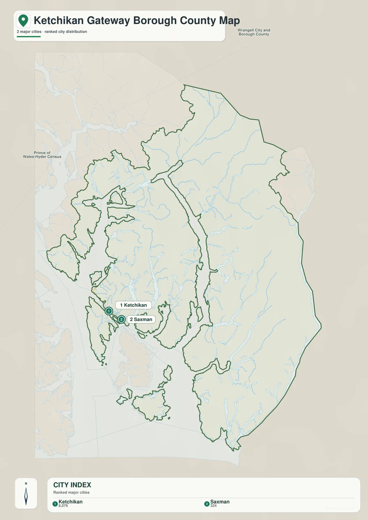
The background labels include Wrangell City and Borough and Prince of Wales-Hyder Census Area. These provide regional context rather than a substitute for a detailed legal-boundary map. When exact administrative data matters, the U.S. Census Bureau TIGER/Line files are a better source. For a reader simply trying to understand where Ketchikan and Saxman sit within the Southeast Alaska borough pattern, the index view is quick and clear.
Unuk, Leduc, and Chickamin rivers define the northern and central mainland valleys
The terrain-and-water map shifts attention away from roads and toward the mainland river valleys. Near the northeast, the Unuk River follows a long mountain corridor toward the coast, with Loks Creek labeled nearby. Farther south, the Klahini River and Leduc River occupy separate valleys before the map reaches the larger Chickamin River system. The shaded relief makes it easy to see that these waterways are constrained by steep terrain rather than crossing a broad flat plain.
The Chickamin River is especially useful as a central reference because it runs through a long valley toward the main coastal water corridor. It sits south of the Unuk and Leduc systems and north of several rivers that appear farther down the map. The rivers are not drawn as one connected urban drainage network; instead, they occupy separate mountain valleys that reach different inlets and coastal channels. This is an important difference from the compact Ketchikan road area shown on the general map.
Blossom, Keta, and Marten rivers lead toward a deeply cut southern coast
In the southeastern portion of the terrain-and-water map, Blossom River, Keta River, and Marten River are labeled in distinct valleys. Boca de Quadra appears along the coast nearby, while the mountain shading continues almost to the water. The pattern is a useful reminder that the borough’s eastern side is not simply an inland block attached to Ketchikan. It is a strongly dissected mountain coast where rivers descend through narrow valleys toward salt water.
Carroll Inlt and George Inlt appear farther west, adding another set of narrow coastal indentations. These features, along with the many islands shown in the center and southwest, make the shoreline difficult to summarize with a single direction. A reader who needs a quick mental map can use the larger named waters as anchors: Ernest Sound to the west, the Unuk and Chickamin river valleys to the northeast and center, Boca de Quadra to the southeast, and Dixon Entrance along the broad southern edge.
Ernest Sound, Moira Sound, and Dixon Entrance show how the borough opens to the coast
Ernest Sound is labeled west of the borough’s northern island-and-mainland section, while Moira Sound appears farther southwest. At the bottom of the map, Dixon Entrance forms the broadest named coastal water. Between those large waters are many smaller passages, island shorelines, and inlets. This arrangement explains why a simple outline map can feel complicated: the boundary repeatedly follows land and water edges instead of enclosing one continuous rectangular or circular area.
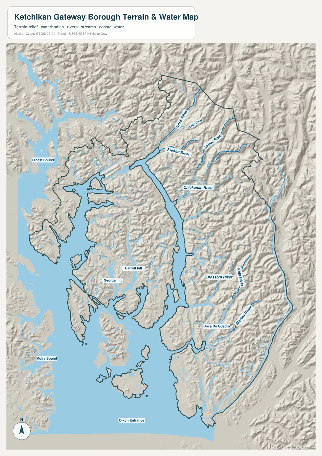
This map is useful for geographic orientation, but it is not a nautical chart, flood map, or real-time hydrology product. It does not provide water depth, navigational hazards, tides, flood stages, or current river conditions. The relief background also shows the shape of mountain terrain rather than precise contour elevations. Readers who need official stream or elevation data should use USGS hydrography and elevation products in addition to this visual map.
Choosing the most useful map for a specific question
Use the general map when the main question is where Ketchikan, Saxman, Route 7, Loring, or Yes Bay Historical sit inside the borough boundary. It provides the best balance of communities, roads, neighboring labels, and water lines. The city-index map is simpler and works well when the goal is to compare the two ranked city locations without the visual detail of the other layers. It quickly shows that the main urban markers occupy only a small part of the borough.
The terrain-and-water map is the strongest choice for rivers, sounds, inlets, and mountain valleys. It is particularly useful for locating the Unuk River and Chickamin River systems or comparing Ernest Sound, Moira Sound, and Dixon Entrance. In a classroom or presentation, showing the general map first and then the terrain-and-water map creates a clear progression from communities and boundaries to natural geography. The maps complement one another rather than serving as interchangeable versions of the same information.
Download the high-resolution Ketchikan Gateway Borough map files
The WebP images in the article are sized for convenient viewing on the page. The ZIP below contains the larger JPG originals for the general borough map, city-index map, and terrain-and-water map. They can be useful for printed reference sheets, classroom materials, presentations, or offline study. High resolution does not turn them into survey documents, nautical charts, flood-hazard products, or engineering maps, so specialized decisions should always be checked against the appropriate official source.
Frequently Asked Questions
Where are Ketchikan and Saxman on the borough maps?
Both appear close together in the southwest portion of the borough. The general map shows them near the Route 7 road cluster, and the city-index map ranks Ketchikan as number 1 and Saxman as number 2. The maps do not define an official commuting area, but they clearly show that the two communities are geographically close compared with the broad eastern mainland.
Which major rivers are labeled on the terrain-and-water map?
The map labels the Unuk, Klahini, Leduc, Chickamin, Blossom, Keta, and Marten rivers, along with Loks Creek. They occupy different mountain valleys and reach the coastal-water system at different points. For official hydrography or current water information, consult USGS sources rather than treating this reference map as a live hydrology product.
What is included in the downloadable ZIP?
The archive contains three high-resolution JPG files matching the subjects shown in the article: the general borough map, the city-index map, and the terrain-and-water map. They are suitable for geographic reference, printing, presentations, and classroom use. The archive does not include survey plats, nautical charts, flood maps, live traffic data, or engineering-grade elevation products.
Map File Information
The Ketchikan Gateway Borough maps shown in this article are available as high-resolution JPG files in one ZIP archive.
- Included Files: 3 high-resolution JPG images
- File Type: JPG files bundled in one ZIP archive
Related Maps
Sources and further reference
For official administrative boundary data, use U.S. Census Bureau TIGER/Line Shapefiles. For official river and hydrography data, see USGS National Hydrography. More detailed elevation data are available from the USGS 3D Elevation Program. The descriptions on this page are based on the place names, water features, relief, roads, and boundaries visible in the supplied Ketchikan Gateway Borough map package.
Green Map creates custom-edited map images using open geographic data sources such as geoBoundaries, Natural Earth, OpenStreetMap, and government open data. These maps are edited visual materials, not raw data files, and are provided for education, documents, presentations, and graphic reference.