Hoonah-Angoon Census Area is a southeastern Alaska geography of islands, narrow channels, deep inlets, and communities separated by large stretches of water. The supplied general map immediately shows why a simple road-based description would not work well here: the census-area outline appears in several distinct pieces, and the labeled communities are spread across different shores and islands. Hoonah, Gustavus, Angoon, Tenakee Springs, and Pelican form the five places highlighted by the city index, while Elfin Cove and Game Creek also appear on the general map. This page explains those settlement positions, the major waterways that make the map easier to navigate, and the differences among the three supplied map types. You can download the three high-resolution JPG map files together from the ZIP box below.
Hoonah is the easiest starting point because it sits near the middle of the mapped area, but it is not the center of a continuous land transportation network. Gustavus lies well to the north in a separate section, Angoon appears far to the south on a long island section, and Pelican and Elfin Cove are positioned toward the western coast. Tenakee Springs is southwest of Hoonah. Water, rather than a single highway corridor, is the strongest organizing feature on the map. Once the shorelines and channels are used as reference points, the scattered settlement pattern becomes much easier to understand.
Table of Contents
Use Hoonah as the anchor for a widely scattered settlement pattern
On the general map, Hoonah provides the most convenient anchor for the central part of the census area. Game Creek is labeled just to its west. Continue farther west and the map shows Pelican and Elfin Cove on different stretches of coast. Tenakee Springs lies southwest of Hoonah, while Angoon is much farther south on the long island section. Gustavus sits north of all of these places in a separate northern section. The gaps between the labeled communities are not empty map space; they contain islands, channels, mountainous terrain, and water that divide the region into distinct local settings.
Road lines are most visible around Hoonah, Game Creek, and Tenakee Springs rather than forming one continuous network across the entire census area. A route shield marked 452 also appears on the narrow eastern island section. These road markings are useful for orientation, but the map does not provide current road conditions, ferry schedules, flight service, or travel times between communities. For that reason, the general map is best used to establish where settlements, boundaries, shorelines, and local road segments sit in relation to one another.
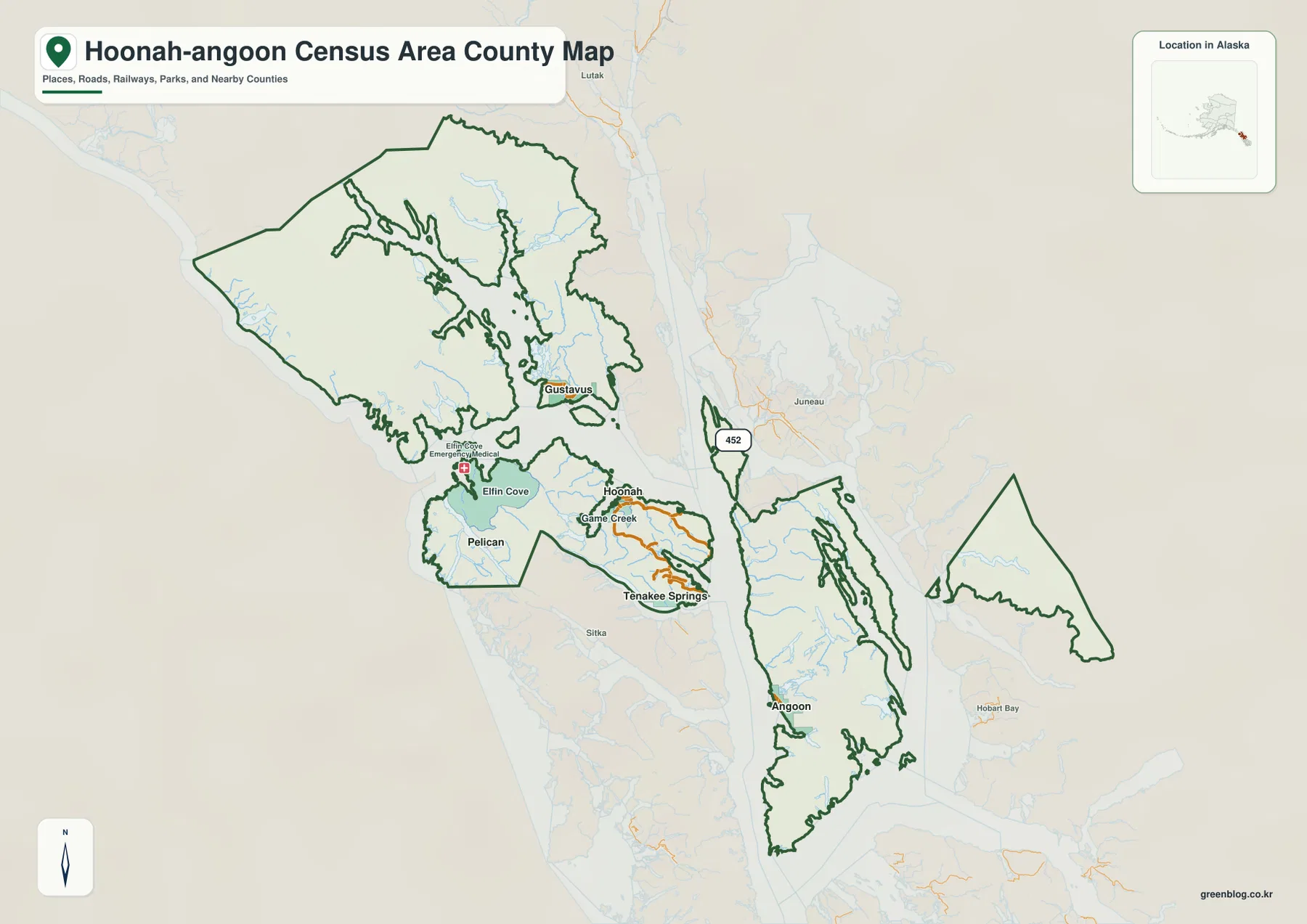
The boundary itself deserves attention because it is one of the clearest differences between this census area and a compact inland county. The map shows a large northwestern section, a central section around Hoonah and Tenakee Springs, a long southern island section around Angoon, and a detached eastern section. Water separates these pieces in several places. Rather than trying to memorize each irregular edge, it is more practical to pair each section with a nearby settlement or named water feature and then use the general map as the overall reference.
The city index reduces the geography to five easy reference points
The city-index map simplifies the region by highlighting five ranked places: Hoonah as 1, Gustavus as 2, Angoon as 3, Tenakee Springs as 4, and Pelican as 5. The printed CITY INDEX also lists the values 862, 594, 480, 116, and 58 beside those names. Those numbers are part of the supplied graphic and are presented here only as map-index values, not as a claim about the latest official population estimates. Anyone needing current population statistics should check the current U.S. Census Bureau QuickFacts table rather than treating the index as a live demographic table.
The more useful lesson from the city map is spatial rather than numerical. Hoonah occupies the central-western portion of the census area, Gustavus is far north, Angoon is far south, Tenakee Springs sits southwest of Hoonah, and Pelican is near the western side. Elfin Cove and Game Creek, both visible on the general map, are not included in the five-place city index. Comparing the two maps therefore makes a useful distinction between all named places shown on the base map and the smaller set selected for the ranked city display.
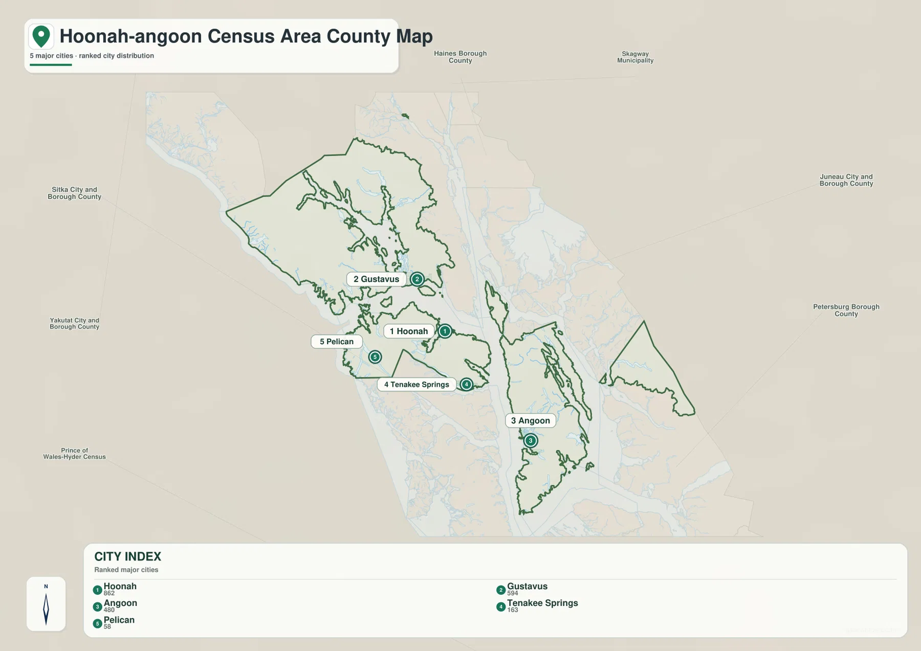
Names such as Haines Borough, Skagway Municipality, Juneau City and Borough, Petersburg Borough, Sitka City and Borough, Yakutat City and Borough, and Prince of Wales-Hyder Census Area appear in the surrounding background. They help show where Hoonah-Angoon Census Area sits within southeastern Alaska, but the city index should not be treated as a legal boundary survey or proof that every background label directly shares a boundary with the census area. Exact administrative geometry should be checked against Census TIGER/Line data when precision matters.
Lynn Canal and the surrounding straits explain the map better than roads alone
The terrain-and-water map makes the coastal structure much easier to follow. Lynn Canal and Chilkoot Inlet are labeled on the eastern and northeastern side of the wider view. Farther south, Frederick Sound and Keku Strait become strong reference features. Peril Strait lies toward the southwest, and the Pacific Ocean label helps orient the western coastal side. Around the detached eastern section, Endicott Arm and Port Houghton provide additional reference points. These water names make it much easier to distinguish one boundary section from another when the shoreline is too complex to remember by shape alone.
Smaller waterways add another layer of detail. Dixon River is labeled in the northwestern section. Mud Bay River appears on the island area west of Hoonah, and Ward Creek is labeled on the northern part of the long southern island section. By starting with a large channel such as Lynn Canal or Frederick Sound and then moving inward to a smaller river or creek, a reader can locate the correct part of the census area without having to rely on a dense list of place names.
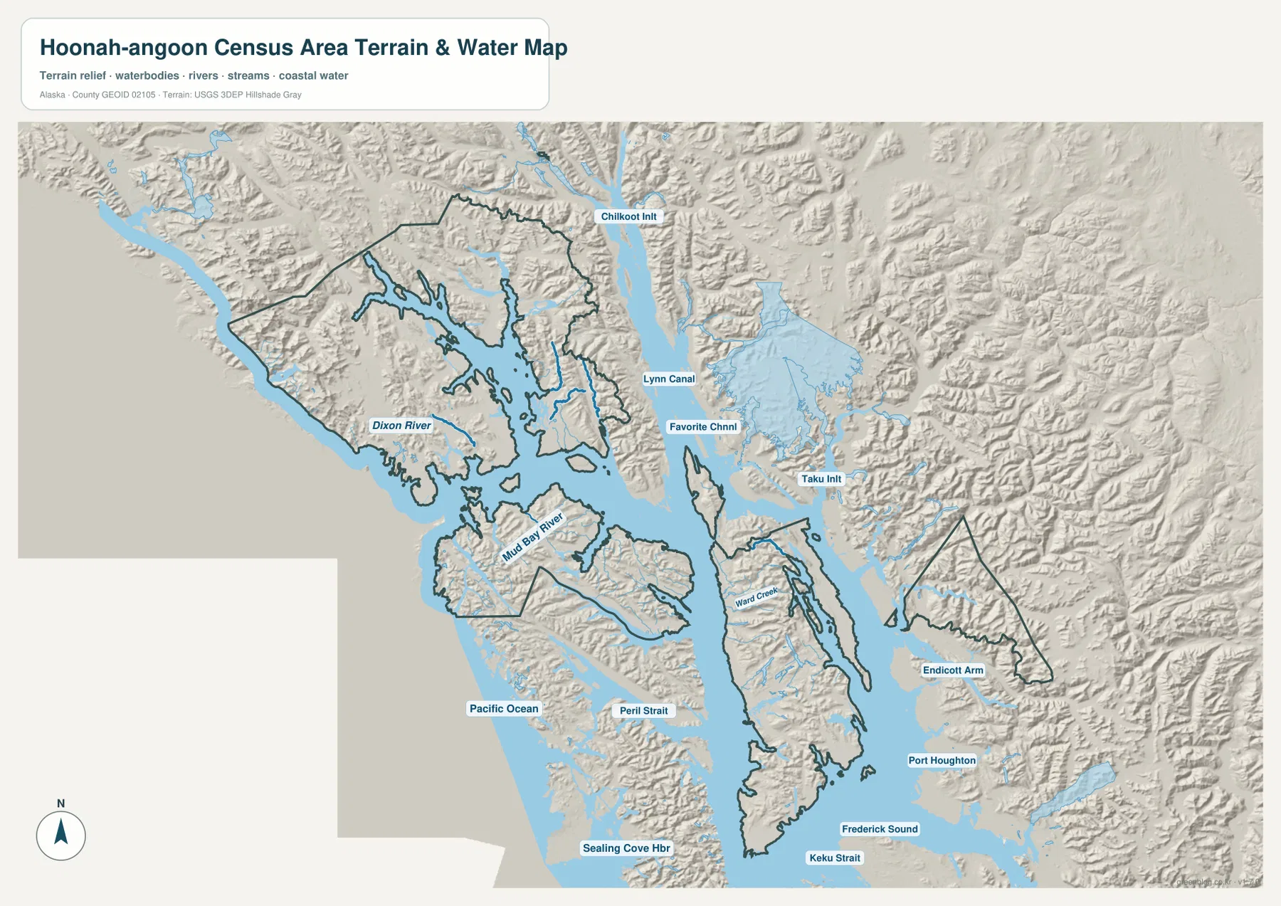
Not every water label on the wider reference map lies wholly inside the census-area boundary. Several surrounding inlets, channels, and sounds are included because they help orient the region. The dark census-area outline should therefore be used for the administrative boundary, while water labels should be used to understand which coast or island section is being viewed. A named inlet is not itself an administrative boundary.
This water layer is also not a flood-risk map, nautical chart, depth survey, tide product, fishing-boundary map, or navigation guide. It is useful for identifying the approximate location and relationship of rivers, straits, inlets, and coastal water. Detailed hydrography should be checked against USGS National Hydrography data, especially when a project depends on exact water features rather than general orientation.
Mountain relief and deeply cut shorelines separate the communities
The shaded terrain background shows a landscape that is much rougher than a broad lowland county. Ridges and narrow valleys repeat across the northern and eastern portions, and the interiors of the larger islands are also strongly textured. Short rivers and streams follow valleys toward the coast, while long inlets cut deep between mountain blocks. This helps explain why the settlement pattern is dispersed. Hoonah, Gustavus, Angoon, Pelican, and Tenakee Springs occupy different coastal settings rather than forming a line of communities along one inland highway.
The northern section around Gustavus has a highly indented shoreline and broad water openings. Around Hoonah, islands and narrow channels break the coast into many smaller pieces. The long southern island section around Angoon is separated from neighboring land by major water corridors, while the detached eastern section near Endicott Arm is backed by particularly rugged relief. Switching between the general map and terrain map makes the relationship between the irregular boundary and the physical landscape much clearer.
The shaded relief should not be treated as survey-grade elevation data. It can show broad differences between rugged mountains, valleys, and lower coastal ground, but it does not provide exact heights or slopes. Construction, engineering, parcel analysis, or detailed elevation work requires a dedicated elevation dataset such as the USGS 3D Elevation Program rather than the generalized relief shown here.
A practical route through the map from Hoonah to Gustavus and Angoon
For a first look, begin at Hoonah on the general map. Move west to Game Creek, then continue toward Pelican and Elfin Cove. Return to Hoonah and look north for the separate Gustavus section. Next move south to Tenakee Springs and then farther south to Angoon. Once those settlement positions are familiar, switch to the terrain-water map and locate Lynn Canal, Peril Strait, and Frederick Sound. The combination of settlement and water references makes the multi-part census-area outline easier to follow than either map by itself.
For the northern part, Chilkoot Inlet and Lynn Canal are useful large-scale anchors. Frederick Sound and Keku Strait help organize the southern side, while Peril Strait is a strong reference toward the southwest. Endicott Arm is one of the clearest features for finding the detached eastern section. Hoonah-Angoon Census Area becomes much easier to understand when each community is paired with one or two nearby water references instead of being treated as an isolated dot.
Pick the map that matches the question
For settlement locations, local roads, shorelines, and the census-area boundary, start with the general map. The city index is better when the main task is comparing Hoonah, Gustavus, Angoon, Tenakee Springs, and Pelican without every secondary label. Channels, inlets, rivers, coastal water, and broad mountain relief are easier to examine on the terrain-water map. Matching the map to the question keeps this complicated coastline easier to follow instead of asking one display to emphasize every useful feature at once.
- Settlements and boundary: Use the general map for Hoonah, Gustavus, Angoon, Tenakee Springs, Pelican, Elfin Cove, Game Creek, roads, and the census-area outline.
- Five ranked centers: Use the city index for a simplified comparison of the five highlighted places and their widely separated positions.
- Inlets, straits, rivers, and terrain: Use the terrain-water map for Lynn Canal, Peril Strait, Frederick Sound, Keku Strait, Endicott Arm, and the labeled rivers and creeks.
- Precise boundary, hydrography, or elevation work: Use these maps for orientation and verify detailed work with Census and USGS source data.
For a classroom or presentation, the general map works well as the opening view because it establishes the unusual multi-part outline and the major communities. The city index can follow with a cleaner five-place comparison. The terrain-water map then explains why the settlements and boundary pieces are so widely separated by showing the channels, inlets, and mountain relief between them. When larger images are needed for printing, slides, or offline reference, the downloadable ZIP below contains the three map subjects as high-resolution JPG files.
Frequently Asked Questions
Which map is best for comparing Hoonah and Angoon?
The general map is the quickest choice. Hoonah appears near the central-western coast of the census area, while Angoon is much farther south on the long island section. The wide water separation between the two locations is immediately visible, making the general map better than the simplified city index for understanding their broader geographic relationship.
Where can I find Lynn Canal, Peril Strait, and Frederick Sound?
Use the terrain and water map. Lynn Canal is labeled on the eastern and northeastern side, Peril Strait is toward the southwest, and Frederick Sound is along the southern side. These names are excellent orientation points for the island geography, but the map does not provide water depth or navigation safety information.
Are the numbers in the city index current population estimates?
No. The values beside Hoonah, Gustavus, Angoon, Tenakee Springs, and Pelican are numbers printed in the supplied city-index graphic and are treated here as part of that map. For current official population figures, check the latest U.S. Census Bureau QuickFacts data.
Map File Information
Download the high-resolution JPG versions of the Hoonah-Angoon Census Area maps described on this page. The ZIP contains one general map, one city-index map, and one terrain-and-water map.
- File Type: JPG files in one ZIP archive
Related Maps
Sources and references
This article is based on the supplied Hoonah-Angoon Census Area general, city-index, terrain, and water maps and the identity information in the provided ZIP. The official resources below are useful when current statistics, exact administrative boundaries, detailed hydrography, or elevation data are needed.
- U.S. Census Bureau QuickFacts – Hoonah-Angoon Census Area, Alaska
- U.S. Census Bureau TIGER/Line Shapefiles
- USGS National Hydrography
- USGS 3D Elevation Program
Green Map creates custom-edited map images using open geographic data sources such as geoBoundaries, Natural Earth, OpenStreetMap, and government open data.
These maps are edited visual materials, not raw data files, and are provided for education, documents, presentations, and graphic reference.