The scale of Aleutians West Census Area is the first thing to understand before looking for any individual town. The mapped region stretches from Unalaska across a long run of western Aleutian islands toward the Attu end of the chain, while St. Paul and St. George appear well away from that line of islands. This Aleutians West Census Area Map page is built around that unusually dispersed geography. It includes a broad county-and-place map, a ranked five-city index, and a terrain-and-water view, and the matching high-resolution JPG files are available together in the download archive.
The current U.S. Census Bureau Alaska county table identifies the area as Aleutians West Census Area, GEOID 02016. Its listed area values are about 11,363 square kilometers of land and 25,198 square kilometers of water. In other words, the mapped county-equivalent is not best understood as one compact land block. Water occupies more than twice the area attributed to land, and the supplied maps make that relationship visible through widely separated islands, large ocean gaps, and communities that cannot be read as a single connected street network.
Table of Contents
The east-to-west span is the defining feature of the county map
Start at the lower-right part of the general map, where Unalaska is labeled beside the Unalaska Courthouse. Nikolski appears to the west, followed farther along the island chain by Atka and Adak. Continue toward the upper-left portion of the map and the labels eventually reach Attu Station and Eareckson Station. The amount of empty water between those names is important. It shows why a small-scale regional view is necessary: a map focused only on Unalaska would hide much of the territory represented by the census area.
Attu is a particularly useful end point for orientation. The National Park Service describes Attu as the westernmost island in the Aleutian chain. The supplied county map is not a historical map, but the Attu Station label gives the reader a clear visual marker for the far-western reach of Aleutians West. Once Unalaska and the Attu end are located, Adak and Atka fall into a more understandable middle position instead of looking like isolated names floating in a large blank page.
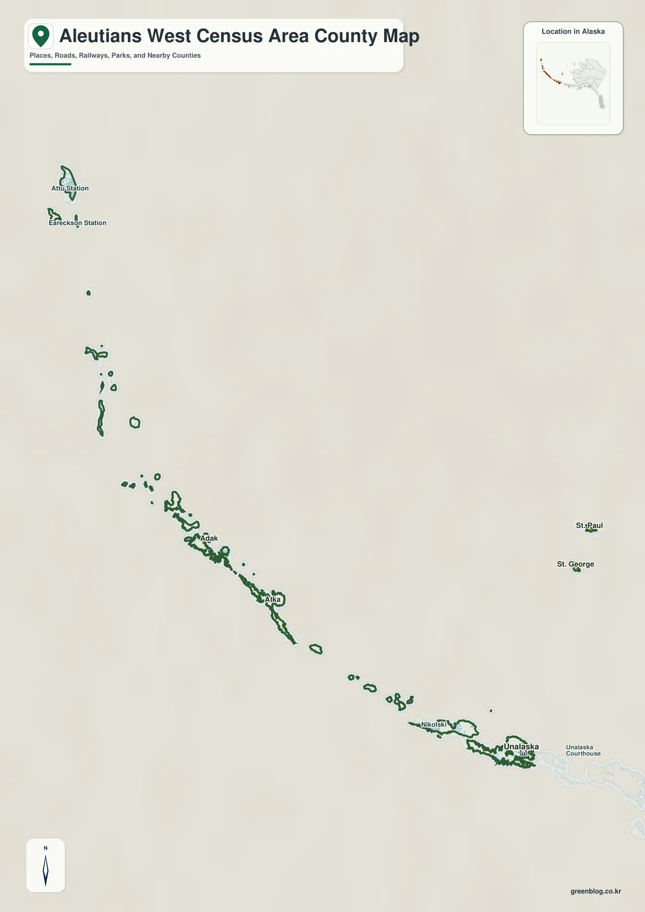
St. Paul and St. George require a different kind of visual reading. They are plotted away from the long Unalaska-to-Attu sequence, with substantial blank space separating them from the main line of western Aleutian islands. That separation is not wasted layout space. It is a direct consequence of fitting distant parts of the census area on the same sheet. For a classroom slide or printed handout, it helps to tell readers in advance that the map contains two very different visual groupings: the elongated Aleutian island chain and the detached St. Paul–St. George pair.
Unalaska dominates the five-city index, while the other cities are widely scattered
The city map adds a ranked CITY INDEX to the geography. The values printed on the supplied map are Unalaska 4,556; St. Paul 378; Adak 73; St. George 70; and Atka 15. These are the values shown in the map itself, so they are presented here as map labels rather than substituted with a different population series. The contrast is immediately clear: Unalaska has by far the largest value in the five-city display, while the other four cities are much smaller.
The ranking does not imply proximity. St. Paul is second in the index and St. George is fourth, yet both appear well apart from Adak, Atka, and Unalaska. Adak ranks third and Atka fifth, but those two are positioned along the western Aleutian sequence rather than near St. Paul or St. George. This is why the city map works best when the number next to each city is read together with the marker position. The index explains relative scale; the map explains how separated those communities are.
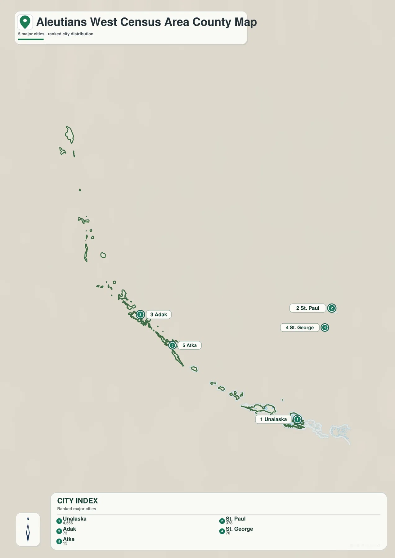
The five-city map is also not a complete gazetteer of every named place that appears on the broader county map. Attu Station, Eareckson Station, and Nikolski can be seen on the general map but are not part of the ranked five-city list. That difference is useful rather than contradictory. One sheet is designed to establish the regional outline and important place labels; the other intentionally narrows the display to five selected cities so their positions and index values are easier to compare.
Water area is larger than land area, and the terrain map makes that obvious
Census boundary data provide a numerical reason for the open appearance of these maps. The current Alaska county table lists roughly 25,198 square kilometers of water for Aleutians West compared with about 11,363 square kilometers of land. The terrain-and-water sheet turns that statistic into a visual impression. Narrow islands and broken coastlines occupy a relatively small part of the page, while water separates nearly every group. Shaded relief in the background gives a broad sense of terrain without pretending to be a survey or engineering elevation product.
Bristol Bay and Unimak Pass are labeled near the eastern side of the terrain-and-water map. Those names help orient the Unalaska end of the region within the larger southwest Alaska setting. From there, the island chain extends westward in a long sequence of larger islands, smaller islands, and open-water gaps. The map is most useful for understanding this large arrangement, not for tracing every stream or trying to infer marine depth from color.
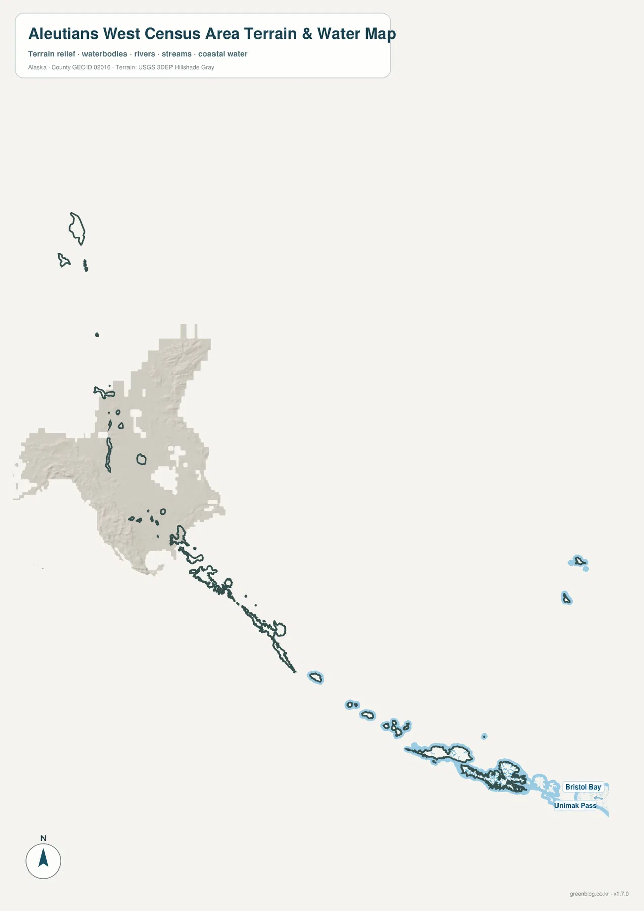
This distinction matters for practical use. The sheet does not contain soundings, channel markers, tide data, current navigation warnings, shoals, or other information required for safe vessel operation. It also does not show official flood zones. Treat it as a regional reference that explains how land and water are arranged across Aleutians West. Mariners should use current official nautical products, and hazard decisions should rely on the appropriate current government data rather than this blog map.
A simple orientation method: anchor on Unalaska, then move west
For a first-time reader, trying to identify every small island at once can make the map harder than it needs to be. A more reliable approach is to use Unalaska as the eastern anchor. It is clearly labeled on the general map, appears as number one in the city index, and is the largest value in that five-city list. The City of Unalaska describes the community as being about 800 miles southwest of Anchorage in the heart of the Aleutian Islands, which helps explain why even the eastern anchor of this page is already far from Alaska’s main population centers.
After locating Unalaska, follow the visible island sequence west through the Nikolski area toward Atka and Adak, and then continue toward the Attu end. This creates a mental line across the page before adding the detached St. Paul and St. George markers. It is much easier to remember the geography as “one very long island sequence plus a separate pair” than as a list of names without direction. That method also makes it obvious why a large blank ocean background is necessary in the design.
The far-western Attu label adds cultural and historical context to the orientation. National Park Service material explains that Attu was home to Unangax̂ people for thousands of years and became a major site of the Aleutian campaign during World War II. The map on this page is not intended to teach that history in detail, but the official NPS material is a useful reminder that the small labels at the western edge represent real places with histories that are easy to overlook when viewing the region only at a statewide scale.
Which map should you open first?
Each supplied sheet answers a different map-reading need, and choosing the right one first prevents the broad geography from becoming cluttered. The general map is strongest when the question is “where is this place within Aleutians West?” The city index is strongest when the question is “how do the five highlighted cities compare and where are they?” The terrain-and-water view is strongest when the reader wants to understand why the region looks so fragmented and how the island chain sits within large areas of coastal water.
- For place location: use the general map to compare Unalaska, Nikolski, Atka, Adak, St. Paul, St. George, Attu Station, and Eareckson Station in one regional frame.
- For the ranked city pattern: use the city index to compare Unalaska, St. Paul, Adak, St. George, and Atka without mixing in every other place label.
- For islands, coast, and regional water: use the terrain-and-water map to follow the broken island chain and locate the labeled Bristol Bay and Unimak Pass side of the map.
For a presentation, a useful sequence is to begin with the general map, switch to the city map to explain how the five highlighted cities are distributed, and finish with the terrain-and-water sheet to show why the ocean gaps are such an important part of the geography. For offline use or printing, the downloadable ZIP contains the same three map subjects as high-resolution JPG files. It does not add an elevation-only sheet or any other map type that is not shown in the article.
Frequently Asked Questions
Why do St. Paul and St. George look detached from the other cities?
Both supplied overview maps place St. Paul and St. George well away from the long Unalaska–Atka–Adak–Attu direction of the western Aleutian islands. The large blank area between them and the main island sequence is therefore part of the regional geography represented at this scale, not a missing-data gap or layout mistake. Keeping the separation visible is necessary if all of those distant locations are going to appear on one page.
Why are Attu Station and Eareckson Station on the county map but not in the five-city index?
The two sheets have different purposes. The general county map includes a broader set of place labels that help orient the reader across the full extent of the census area. The city sheet is explicitly a ranked five-city display limited to Unalaska, St. Paul, Adak, St. George, and Atka. A label that appears on the general map therefore does not automatically belong in the city index.
Can the terrain-and-water map be used for marine navigation?
No. It is a regional reference map showing islands, coastal water, broad terrain shading, and a few named regional water features. It does not include the depth soundings, navigation aids, hazards, tide information, or current notices required for safe navigation. Use current official nautical charts and navigation products for marine travel.
Map File Information
Download high-resolution JPG copies of the Aleutians West Census Area maps shown in this article. The archive is intended for readers who need larger files than the web-sized images for printing, teaching, or presentations.
- Included Versions: county and place map, five-city index map, terrain and water map
- Included Files: 3 high-resolution JPG files
- File Type: JPG files in one ZIP archive
- Intended Use: regional reference, printing, education, and presentations
Related Maps
Sources and references
The map descriptions above are based on the supplied map images and manifest, with official sources used to confirm the census-area identity, current area statistics, regional hydrography context, and selected information about Unalaska and Attu. These links provide authoritative starting points for readers who need more detail than the downloadable reference maps contain.
- U.S. Census Bureau QuickFacts – Aleutians West Census Area
- U.S. Census Bureau TIGERweb – Alaska Counties
- City of Unalaska – History
- National Park Service – Attuans’ WWII Experience
- USGS National Hydrography
Green Map creates custom-edited map images using open geographic data sources such as geoBoundaries, Natural Earth, OpenStreetMap, and government open data.
These maps are edited visual materials, not raw data files, and are provided for education, documents, presentations, and graphic reference.