Aleutians East Borough stretches across the western end of the Alaska Peninsula and a chain of offshore islands, so its communities are not arranged around one road network or one continuous block of land. Akutan, False Pass, Cold Bay, King Cove, Sand Point, and Nelson Lagoon occupy very different coastal settings, from separate islands to opposite sides of the peninsula. This page uses the Aleutians East Borough Map, a ranked city map, and a terrain-and-water map to show how those places fit together. The same three subjects are also available below as original high-resolution JPG files in a downloadable ZIP, which is useful when you need larger labels for printing or close inspection.
The three maps answer different location questions without pretending to be navigation or engineering products. The general borough map is the best starting point for the long boundary and the six named communities. The city map focuses on the five incorporated cities and uses numbered markers to make them easier to find. The terrain-and-water layer adds rivers, lakes, bays, passes, coastline, and shaded relief, including Caribou River, Sapsuk Lake, Emmons Lake, Milky River, and a cluster of named bays on the eastern side of the borough.
Table of Contents
A borough stretched across peninsula shores and offshore islands
The borough’s shape is the first thing to understand. Its northeastern end follows the Alaska Peninsula, while the southwestern portion reaches across narrow passages and island groups. Akutan appears on an island at the western end of the map. False Pass lies farther east at the eastern end of Unimak Island, Cold Bay and King Cove sit near the western end of the peninsula, and Sand Point is positioned on the island side to the east. Nelson Lagoon stands apart on the peninsula’s north coast.
That pattern matters because a short distance on the page does not mean a simple trip on the ground. The borough’s official community information identifies Akutan, Cold Bay, False Pass, King Cove, and Sand Point as incorporated cities and describes Nelson Lagoon separately as a village. It also explains that the remote communities are not connected to one another by roads. Water, rugged land, island separation, aviation, and marine transportation therefore matter more here than they do in a typical county built around highways.
For that reason, these maps work best as geographic orientation tools. They can help a reader explain where a community sits relative to the peninsula, nearby islands, and major water features, but they should not be used to estimate a driving itinerary or to make legal boundary decisions. Current transportation schedules, nautical products, parcel records, and other purpose-specific sources are still necessary when a task depends on operational or legal accuracy.
Use the boundary map to connect communities that are far apart
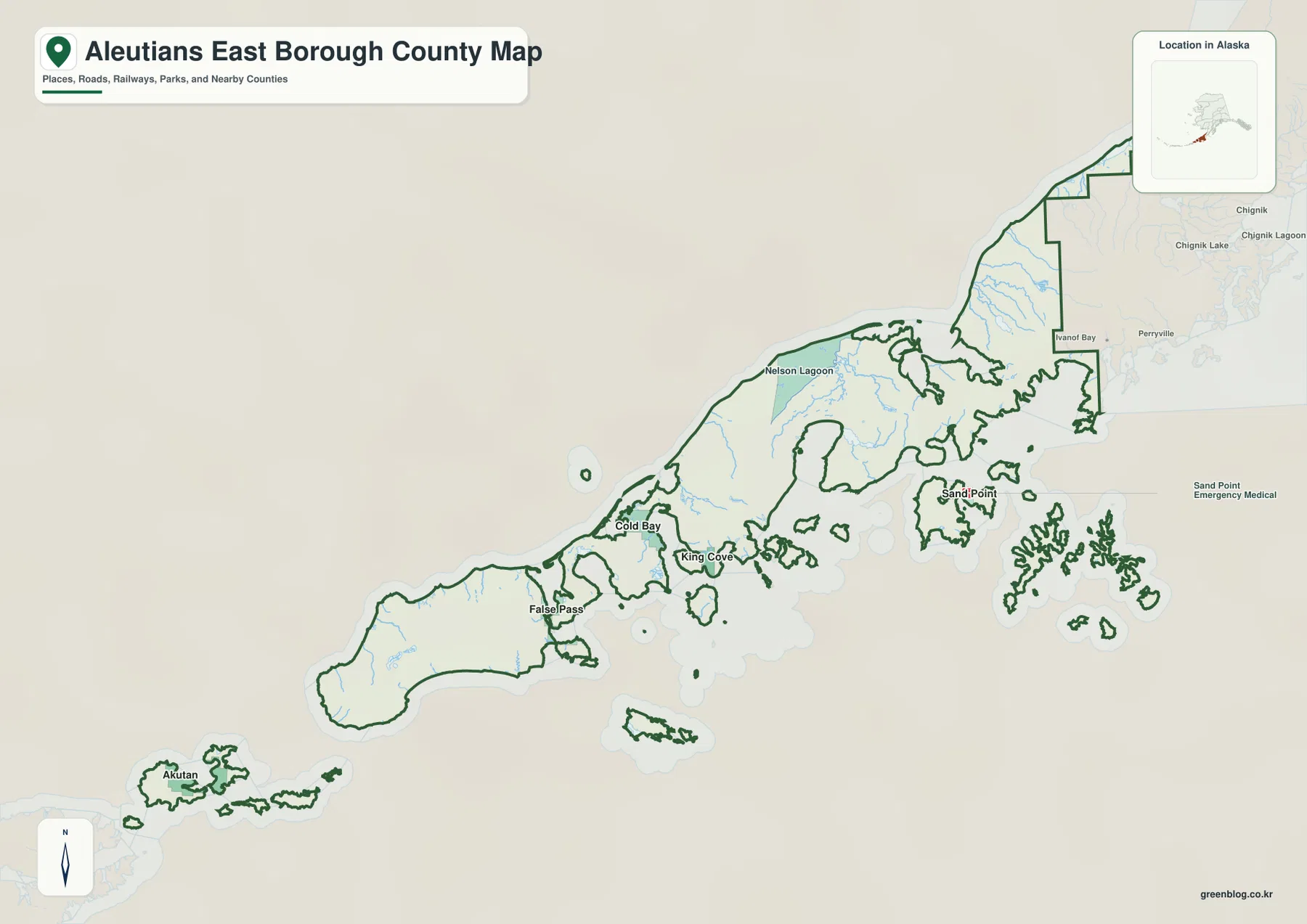
The general map gives the clearest overview of the borough’s fragmented outline. Following the boundary from Akutan toward Sand Point shows that the borough is made up of peninsula land and many offshore pieces rather than one uninterrupted shape. False Pass occupies a narrow island-and-passage setting, while Cold Bay and King Cove are relatively close together on the peninsula side. Sand Point lies well to the east in the island group, and Nelson Lagoon is separated from the main cluster of southern communities by its north-coast position.
This map is especially helpful when several community names must be placed in one regional frame. King Cove and Cold Bay can be compared quickly, but the same view also makes it clear that Akutan and Sand Point are not simply western and eastern suburbs of those places. They are separated by water and by the long, irregular form of the borough. Nelson Lagoon adds another direction entirely, because it sits along the northern shore rather than the southern coastal arc where several other communities appear.
The map also provides regional context beyond the borough line. Lake and Peninsula Borough continues to the northeast, while Aleutians West Census Area lies beyond the western side of the mapped region. Those labels are useful for orientation, but the page is not a legal boundary survey. When an exact administrative boundary is needed, the current U.S. Census Bureau TIGER/Line files are a better authority to use alongside the visual map.
Five incorporated cities stand out on the ranked city index
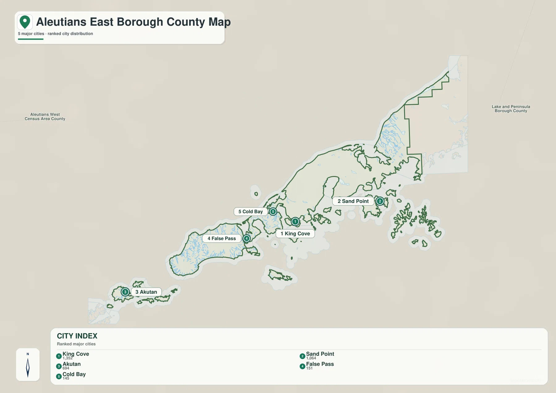
The city layer strips away some of the general-map clutter and gives the five incorporated cities numbered markers. King Cove is number 1, Sand Point number 2, Akutan number 3, False Pass number 4, and Cold Bay number 5. The index printed along the bottom also shows the values 1,352, 1,064, 694, 151, and 145 beside those names. Even without using the figures for any later statistical comparison, the ranked index is a convenient way to match a label with its marker on a coastline that would otherwise be easy to lose track of.
The numbered locations also show how widely the incorporated cities are dispersed. King Cove and Cold Bay sit on the peninsula side, but False Pass is southwest on Unimak Island and Akutan is farther west again on a separate island. Sand Point is located in the opposite direction, on the island side east of the peninsula communities. A reader who sees only a list of five city names could easily miss how much water and coastline separates them; the map makes that distribution obvious.
Nelson Lagoon is not numbered on this city map because the layer is built around the five incorporated cities. The borough’s own material lists Nelson Lagoon separately as a village, so the absence of a numbered marker is consistent with the map’s purpose rather than a missing community. Use the general boundary map when all six communities need to appear together, and use the ranked map when the five city locations are the focus.
Water names explain more of the landscape than roads do
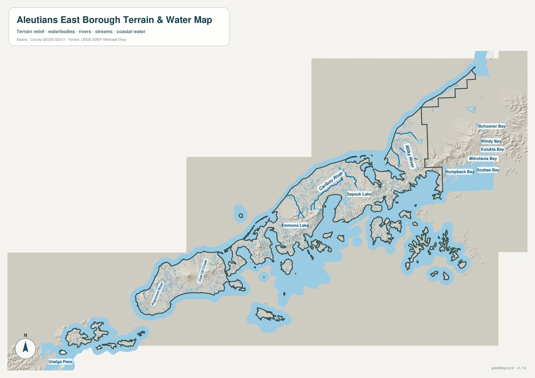
The terrain-and-water map provides the strongest explanation for the borough’s physical setting. Caribou River and Sapsuk Lake are labeled near the central peninsula area, while Emmons Lake appears farther west. Milky River is shown toward the northeastern peninsula. Around the False Pass side, Roberts River and smaller streams can also be seen. These inland names sit within a much larger pattern of deeply indented coastlines and offshore islands.
On the eastern edge, the map labels Schooner Bay, Windy Bay, Kuiukta Bay, Mitrofania Bay, Humpback Bay, and Sosbee Bay in close succession. Unalga Pass appears near the southwestern island area. The concentration of bays and passages is useful because it shows why a simple outline map cannot tell the full story of the borough: many communities occupy places where land and sea interlock at a small scale.
Shaded relief adds another layer of context. It makes rugged land behind the coastline easier to distinguish from lower-looking areas, but it is not a survey-grade elevation surface. Likewise, the blue hydrography is not a nautical chart, bathymetric map, or flood-risk product. The map is appropriate for identifying the relative position of a river, lake, bay, pass, or coastal landform; navigation, hazard, construction, and engineering decisions require current specialized products from the responsible agencies.
Viewed together with the community maps, the water layer explains why the borough is better understood through coastlines than highways. Akutan and Sand Point are island communities, False Pass lies beside a narrow marine passage, and King Cove and Cold Bay sit among irregular peninsula shores. Nelson Lagoon’s position on the north coast is different again. This makes the terrain-and-water map useful for regional introductions, classroom material, and reports that need to explain why settlements within one borough can still feel geographically separate.
Which map works best for orientation, comparison, or printing?
Choose the general borough map when the main question is where the communities and administrative outline are located. It is the only supplied map that places Akutan, False Pass, Cold Bay, King Cove, Sand Point, and Nelson Lagoon together in one broad view. For a presentation or regional overview, that makes it the most straightforward first image.
Choose the ranked city map when you want to compare the five incorporated cities without treating Nelson Lagoon as one of them. The numbered markers and bottom index are convenient for a slide, handout, or demographic note where city identity matters. Choose the terrain-and-water map when the question is about named rivers, lakes, bays, passes, or the relationship between coastal settlement and rugged terrain.
For printing or close inspection, use the downloadable JPG archive rather than relying only on the smaller WebP previews embedded in the article. The ZIP contains the general borough map, ranked city map, and terrain-and-water map as three original JPG files. Each image is 3638 by 2572 pixels and is prepared at A3 size, giving you more room to enlarge small labels or place the maps into personal study notes, classroom material, and presentation layouts.
Frequently Asked Questions
Why does Nelson Lagoon have no number on the city map?
The borough identifies Akutan, Cold Bay, False Pass, King Cove, and Sand Point as five incorporated cities and lists Nelson Lagoon separately as a village. The ranked city map was designed around those five cities, so Nelson Lagoon does not receive a numbered marker. Use the general borough map when you need all six communities in one view.
Does a short map distance mean there is a driving route?
No. The borough’s official community information states that the remote communities are not connected by roads. Water, islands, rugged terrain, and transportation availability can make the real trip very different from the straight visual distance between two labels. Check current air and marine transportation information before planning travel.
Can the terrain-and-water map be used for navigation or flood decisions?
No. It is a geographic reference for the relative position of rivers, lakes, bays, coastline, and terrain. It does not provide water depth, tides, navigation channels, flood probability, or evacuation zones. Use current NOAA, USGS, borough, or other purpose-specific official products when safety or technical accuracy is required.
Map File Information
The archive contains the general Aleutians East Borough map, ranked city map, and terrain-and-water map as original high-resolution JPG files.
- Included Versions: General borough map, ranked city map, terrain-and-water map
- Included Files: Three high-resolution JPG files in one ZIP archive
- Printable Size: A3, 3638 × 2572 pixels
- File Type: JPG, ZIP
- Intended Use: Printing, education, presentations, and geographic reference
Related Maps
Aleutians East Borough map sources and references
- Aleutians East Borough – Our Communities: official community locations, city/village structure, and local transportation context
- Aleutians East Borough – Government: official borough government and regional information
- U.S. Census Bureau TIGER/Line Shapefiles: authoritative administrative boundary reference
- USGS National Hydrography: official hydrography reference for rivers, lakes, and other water features
Green Map creates custom-edited map images using open geographic data sources such as geoBoundaries, Natural Earth, OpenStreetMap, and government open data.
These maps are edited visual materials, not raw data files, and are provided for education, documents, presentations, and graphic reference.