South Dakota is a low-density state overall, but its residents are not spread evenly across the map. The strongest concentration is in the southeast around Sioux Falls. Rapid City and the Black Hills form a separate western population hub, while Aberdeen, Brookings, Watertown, Mitchell, Yankton, Pierre, and several smaller cities appear as isolated centers across a much more lightly settled landscape. The supplied 2024 ACS 5-year estimate places the state population at 907,428, and the county data imply an average density of about 12 people per square mile.
The five maps answer different questions. Proportional circles on the city and county-population maps represent total residents, not density. The county-density map divides population by land area, while the census-tract layer reveals local variation inside counties. The 2010–2020 change map compares two decennial censuses rather than describing a 2024 trend. That distinction matters because Minnehaha County is the current leader in both population and density, while neighboring Lincoln County was the fastest-growing county during the 2010s.
Table of Contents
Sioux Falls is the clearest continuous density cluster on the tract map
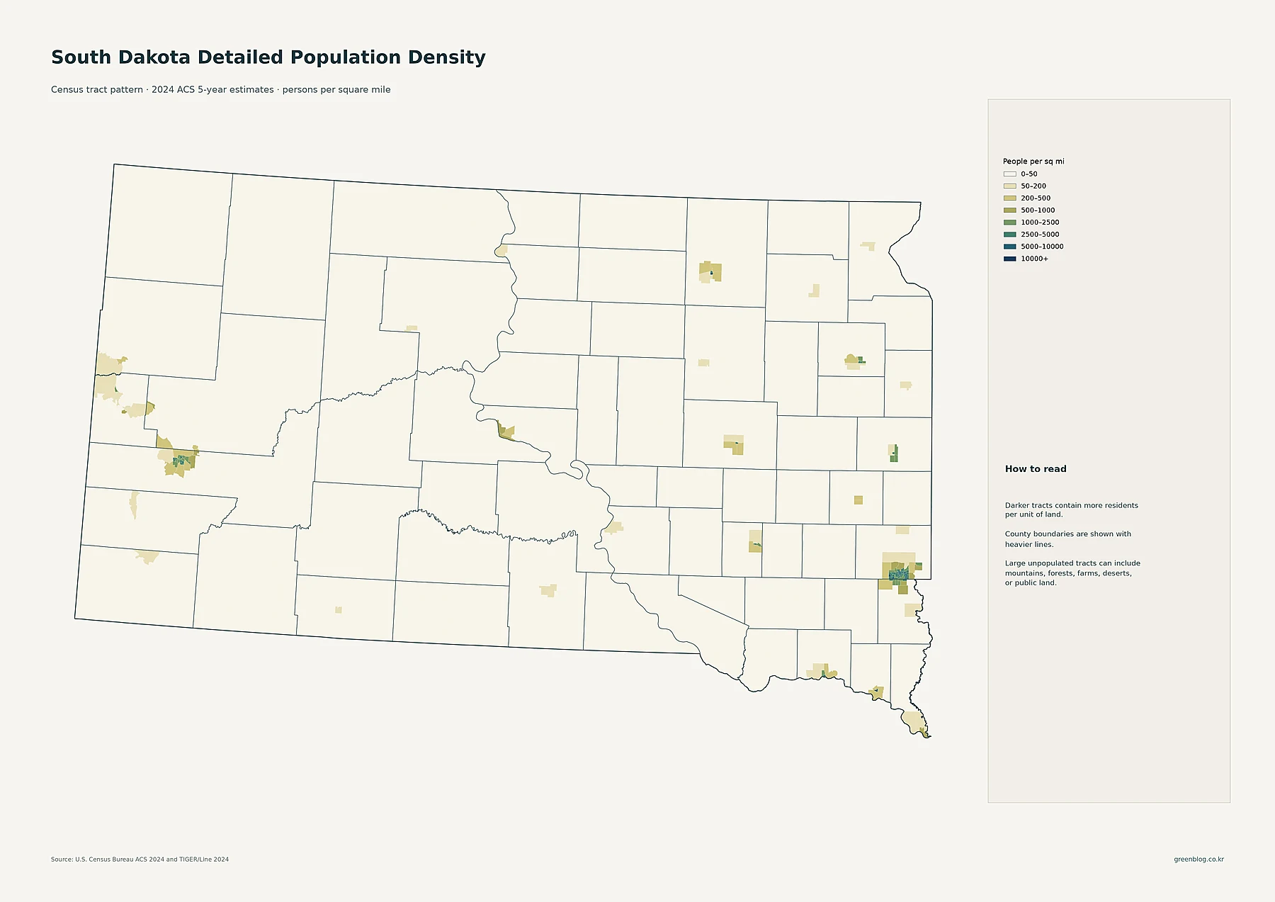
The darkest and broadest tract cluster sits around Sioux Falls near the Minnehaha–Lincoln county line. High-density tracts cover the urban core and extend toward nearby communities such as Brandon, Harrisburg, and Tea. Against the mostly pale statewide background, the southeastern concentration is visually unmistakable. It is the only part of South Dakota where a relatively broad group of higher-density tracts forms one connected metropolitan pattern.
Western South Dakota has a second major concentration around Rapid City. Higher-density tracts appear in and around Rapid City, Box Elder, Rapid Valley, Sturgis, and Spearfish. The Black Hills settlement pattern is more dispersed than the Sioux Falls area, but it still forms a recognizable western system across portions of Pennington, Meade, and Lawrence counties.
Elsewhere, Aberdeen, Brookings, Watertown, Mitchell, Huron, Yankton, and Pierre appear as small islands of higher density surrounded by extensive rural tracts in the 0–50 people-per-square-mile class. That is why the tract map adds information that a county average cannot provide. A large rural county can contain a compact town with much higher density even when the county as a whole remains sparsely settled.
Sioux Falls has more than twice the place population of Rapid City
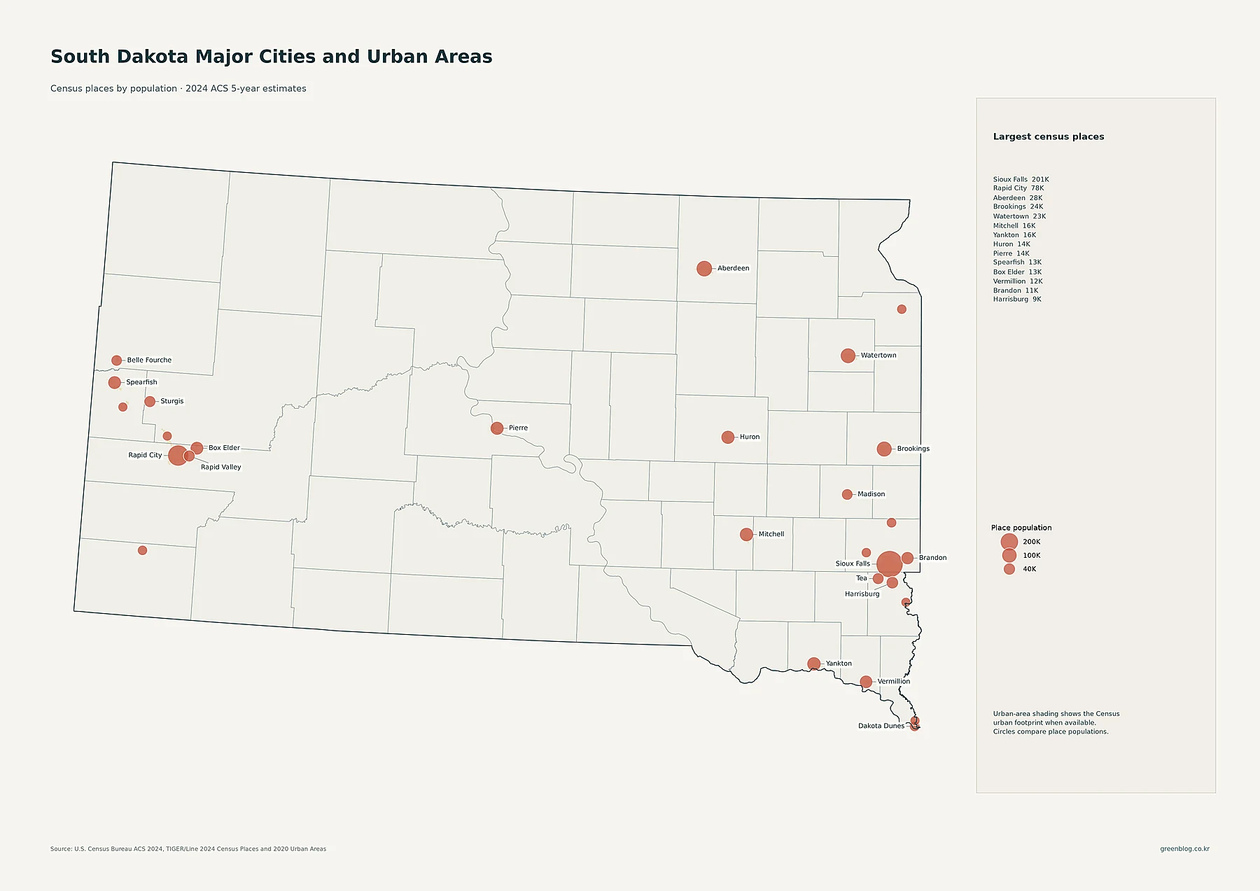
Sioux Falls has 201,469 residents in the supplied census-place data, making it by far the largest place in the state. Rapid City is second at 77,946. Aberdeen has 28,189 residents, Brookings 23,948, and Watertown 23,044. Mitchell has 15,649, Yankton 15,540, Huron 14,385, Pierre 13,948, Spearfish 12,930, and Box Elder 12,902.
The Sioux Falls area also contains several growing suburban places. Brandon has 10,996 residents, Harrisburg 8,519, and Tea 6,786. In the west, Sturgis has 7,086 residents and Rapid Valley 6,975. The geographic arrangement is important: the southeast contains one dominant city surrounded by several nearby communities, while western population centers are spread across a wider Black Hills area.
The proportional circles show total place population. They do not directly measure people per square mile. A large circle therefore identifies a large place population, while the tract-density map answers the separate question of how tightly those residents occupy land within and around each community.
Minnehaha County leads total population, with Pennington a distant second
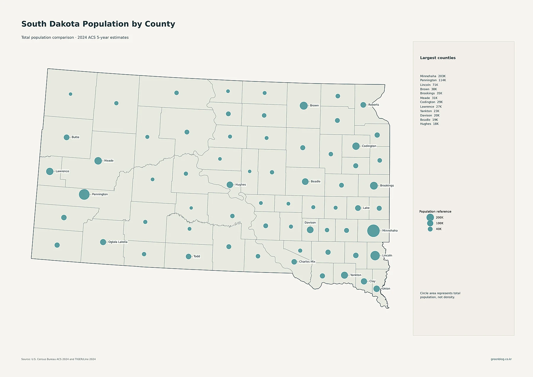
Minnehaha County has 203,289 residents, the largest county total in the supplied data. Pennington County is second with 113,512, followed by Lincoln County at 70,638. Brown County has 37,877 residents, Brookings 35,353, Meade 30,546, Codington 28,767, and Lawrence 27,233. Yankton has 23,414, Davison 19,952, Beadle 19,309, and Hughes 17,664.
The biggest circles align closely with the state’s two largest cities. Minnehaha contains most of Sioux Falls, while Pennington contains Rapid City. Lincoln County, which contains part of the Sioux Falls metropolitan fringe and fast-growing communities south of the city, has the third-largest current county population. Its historical growth rate is even more notable, as the change map shows later.
Many counties have very small totals. Jones County has 1,004 residents, Hyde 1,191, Sully 1,526, and Jerauld 1,772. Total population alone does not establish density because county land areas differ. The county-population map is best used to compare how many people live within each county boundary.
Minnehaha is also the densest county, with Lincoln clearly second
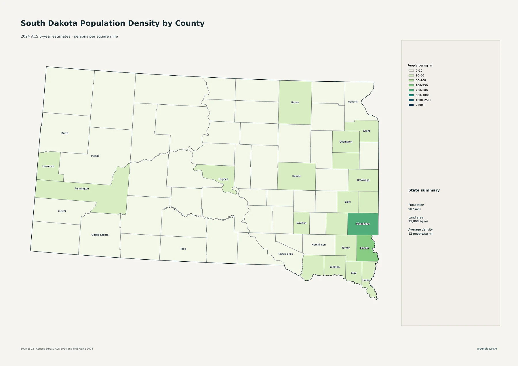
Minnehaha County has the highest average density at about 252.0 people per square mile. Lincoln County is second at about 122.4. The next tier drops sharply: Davison averages about 45.8, Yankton 44.9, Brookings 44.6, Codington 41.8, and Pennington 40.9 people per square mile.
Union County averages about 37.1 people per square mile, Clay 36.9, and Lawrence 34.0. At the sparse end, Jones County averages about 1.04 person per square mile, Ziebach 1.21, Hyde 1.38, Mellette 1.49, Jackson 1.50, and Sully 1.52. The difference between Minnehaha and the sparsest counties exceeds two hundred to one.
This is why the statewide average of roughly 12 people per square mile should not be treated as a uniform description. Sioux Falls and its surrounding counties are much denser than the state average. Rapid City and several eastern county seats form a middle tier, while a large number of central and western counties remain in the single digits.
| Measure | Leading area | Value in supplied data |
|---|---|---|
| State population | South Dakota | 907,428 |
| Largest county population | Minnehaha County | 203,289 |
| Highest county density | Minnehaha County | about 252.0/sq mi |
| Fastest 2010–2020 growth | Lincoln County | +45.4% |
| Largest 2010–2020 decline | Jerauld County | -19.7% |
Lincoln County’s 45% growth makes the Sioux Falls fringe the decade’s standout
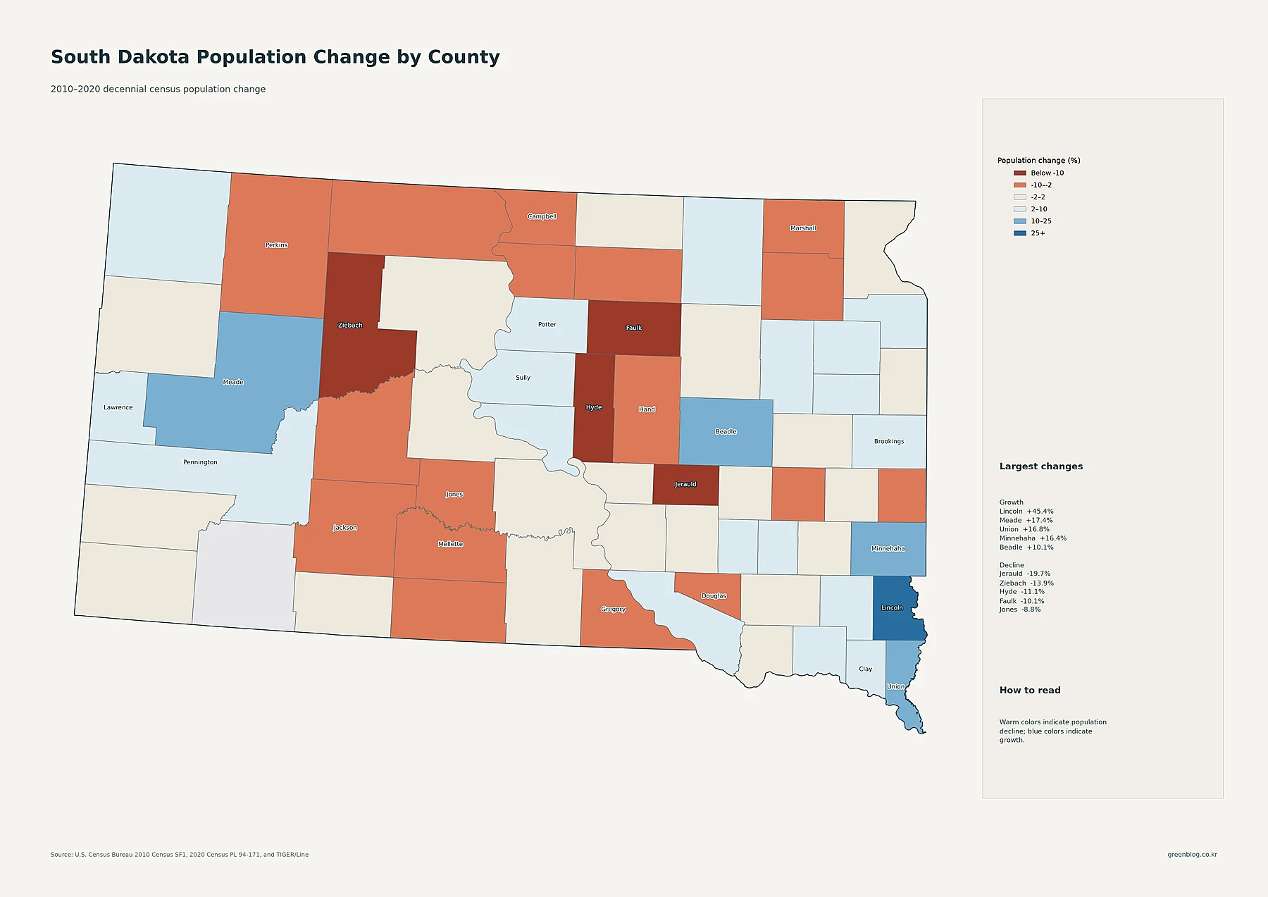
Lincoln County recorded the fastest percentage growth in the supplied decade data. Its population rose from 44,828 in 2010 to 65,161 in 2020, an increase of about 45.4%. Meade County grew 17.4%, Union 16.8%, and Minnehaha 16.4%. Beadle increased 10.1%, Pennington 8.2%, Clay 8.0%, Brookings 7.5%, and Lawrence 6.9%.
The map makes two growth regions easy to identify. Lincoln, Minnehaha, and Union form a strong southeastern group around the Sioux Falls area. In the west, Meade, Pennington, and Lawrence grew around Rapid City and the Black Hills. The county with the largest current population, Minnehaha, did grow strongly, but neighboring Lincoln expanded much faster in percentage terms.
Several counties declined sharply. Jerauld County fell from 2,071 residents in 2010 to 1,663 in 2020, a decrease of about 19.7%. Ziebach declined 13.9%, Hyde 11.1%, Faulk 10.1%, Jones 8.8%, and Hand 8.3%. Marshall, Jackson, Gregory, and Mellette also lost population. These percentages belong specifically to the 2010–2020 decennial-census period and should not be described as 2024 ACS changes.
South Dakota’s population story is a concentrated southeast, a western hub, and a sparse interior
Across all five maps, the southeastern corner is the clearest current population core. Sioux Falls is the largest census place, and Minnehaha County leads both county population and county-average density. Lincoln County is smaller today but recorded the fastest growth during the 2010s, while nearby Brandon, Harrisburg, and Tea reinforce the suburban pattern around Sioux Falls.
Rapid City and the Black Hills form the second major system. Pennington County has the state’s second-largest county population, and Meade and Lawrence contribute additional western growth and settlement. Aberdeen, Brookings, Watertown, Mitchell, Yankton, and Pierre serve as more isolated regional centers. Much of the central and western interior remains very sparse, and several small counties lost population during the decade. Keeping place totals, county totals, county density, tract density, and historical change separate provides the most accurate view of how South Dakota’s population is organized.
Download the South Dakota population map collection
The ZIP includes detailed census-tract density, major cities and urban areas, county population totals, 2010–2020 county population change, and county population density.
FAQ
Which South Dakota county has the largest population?
Minnehaha County is the largest in the supplied 2024 ACS 5-year estimates, with 203,289 residents. Pennington County has 113,512 and Lincoln County 70,638.
Which South Dakota county has the highest population density?
Minnehaha County has the highest county-average density at about 252.0 people per square mile. Lincoln County is about 122.4 and Davison County about 45.8 people per square mile.
Which South Dakota county grew fastest from 2010 to 2020?
Lincoln County grew about 45.4%, followed by Meade at 17.4%, Union at 16.8%, and Minnehaha at 16.4%. These percentages compare the 2010 and 2020 decennial censuses.
Related Maps
Sources
- U.S. Census Bureau — American Community Survey (ACS): 2024 5-year population and density estimates
- U.S. Census Bureau — TIGER/Line Shapefiles: 2024 state, county, census tract, and census place boundaries
- U.S. Census Bureau — Decennial Census: 2010 and 2020 county population comparison
Green Map creates custom-edited map images using open geographic data sources such as geoBoundaries, Natural Earth, OpenStreetMap, and government open data.
These maps are edited visual materials, not raw data files, and are provided for education, documents, presentations, and graphic reference.