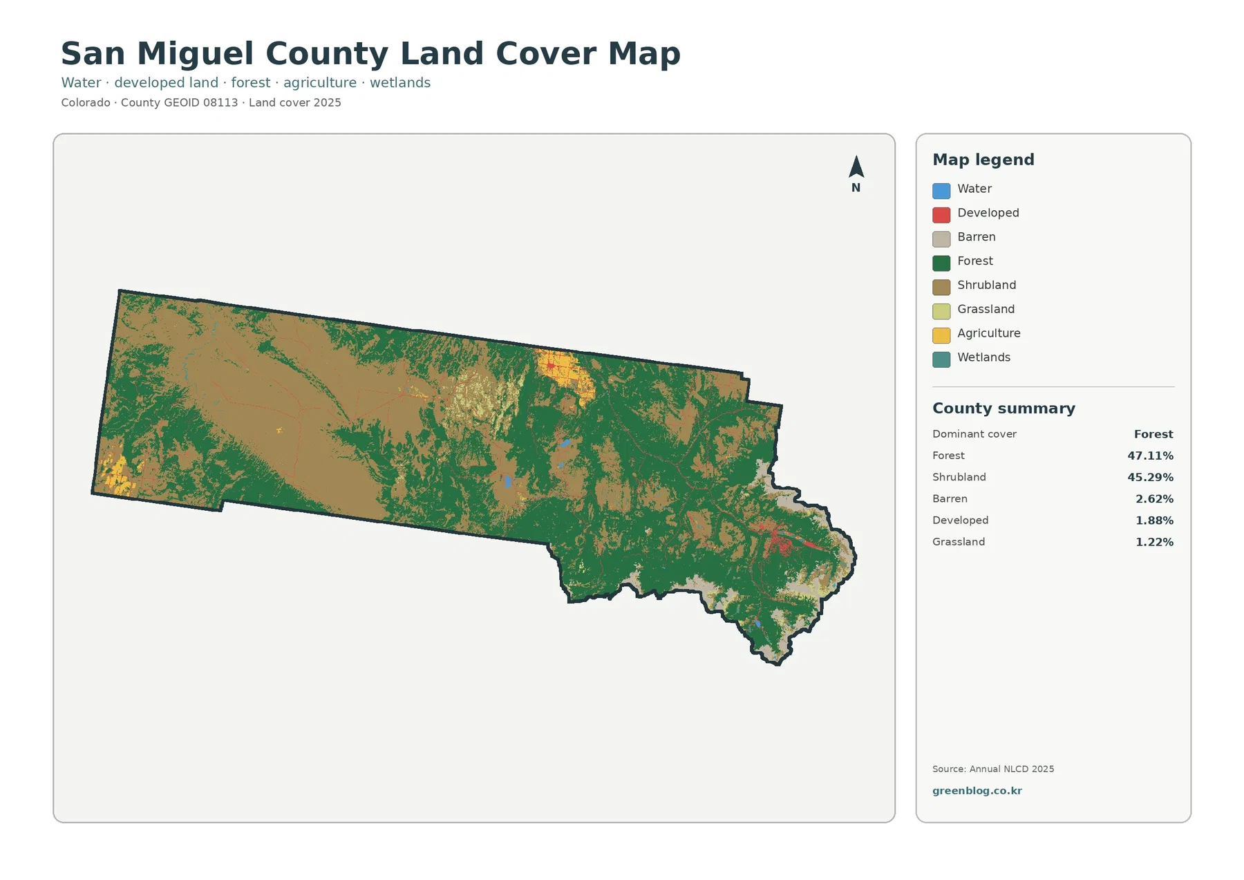
San Miguel County has a striking split between broad shrubland in the west and extensive forest across the eastern and southern mountains. The 2025 summary puts forest at 47.11% and shrubland at 45.29%, so those two classes account for nearly the entire county. Barren ground adds 2.62%, developed land 1.88%, and grassland 1.22%, while agriculture, wetlands, and water occupy much smaller shares.
This page brings together four views: current land cover, forest and farmland, impervious surface and developed land, and mapped class differences from 1985 to 2025. The four original JPG maps are also available together in one ZIP near the end of the page for classroom work, regional comparisons, presentations, and general environmental reference.
Table of Contents
A county divided between shrub-covered mesas and forested mountains
The current land-cover map is useful because it makes the west-to-east contrast visible before any percentages are considered. Much of the western half is dominated by shrubland, shown as a broad continuous field with forest entering along edges and higher terrain. Moving east, forest becomes increasingly common and eventually forms the main cover across the mountainous end of the county.
Forest and shrubland are close in total area, but they do not occupy the same places. Forest covers 47.11% of the county and shrubland 45.29%, a difference of only 1.82 percentage points. Their spatial separation matters more than that small numerical gap: the map shows a large western shrubland zone, a heavily forested east, and a central transition where the two classes intermix.
Barren land accounts for 2.62%. It appears in irregular patches, especially where the eastern high country breaks up the forest cover. Grassland is only 1.22% and occurs in smaller openings. Water is 0.11% and wetlands 0.64%, so they are minor in total area even though narrow water-related features can still matter locally.
Land cover should not be read as zoning or ownership. Annual NLCD classifies the visible surface into raster cells, assigning categories such as forest, shrubland, agriculture, water, or developed land. A parcel can contain several classes, and a land-cover color does not say whether the property is public, private, protected, buildable, or subject to a particular zoning rule.
Town development is compact when viewed against the county as a whole
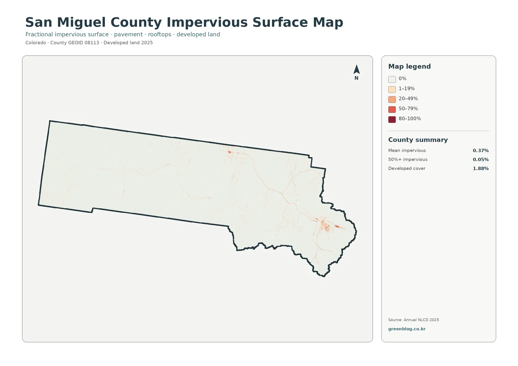
The impervious-surface map strips away most natural-cover colors and focuses on hard surfaces such as pavement and rooftops. San Miguel County has a mean impervious value of 0.37%, and only 0.05% of the county is mapped at 50% impervious or higher. Developed cover is 1.88%, confirming that built surfaces occupy a small part of the countywide landscape.
The strongest concentration appears in the eastern part of the county around Telluride and Mountain Village. San Miguel County’s official Open Lands map identifies those communities along with Placerville, Sawpit, Ophir, and Norwood. Comparing those locations with the impervious map helps place the bright clusters without treating the raster as a street map.
A separate, smaller concentration appears around the Norwood area farther west and north. Thin traces also extend along travel and settlement corridors between larger clusters. The map does not show property lines, street names, or individual building footprints, so it is best used to compare where hard surfaces are concentrated rather than to identify a specific structure.
Developed cover and impervious percentage answer different questions. A low-density developed cell may contain trees, soil, lawn, or other permeable surfaces in addition to buildings and roads. The developed class can therefore cover more area than the portion measured as truly impervious surface.
Forest and farmland are easier to separate on the simplified map
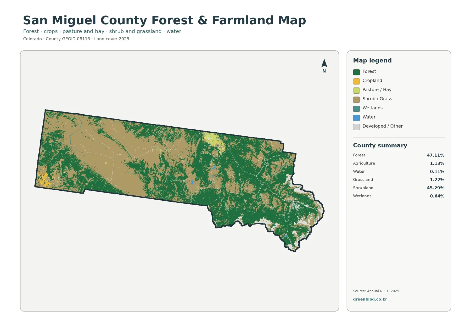
The forest-and-farmland view groups the landscape into fewer categories, making small agricultural areas easier to find. Forest remains the dominant cover across the east and much of the south, while shrub and grass cover most of the west. Agriculture represents 1.13% of the 2025 summary and appears in limited patches rather than as a broad countywide belt.
Several agricultural patches stand out near the western edge and in the north-central portion of the county. San Miguel County’s Master Plan page separately lists Wrights Mesa planning material, while the official Open Lands map places Norwood in that broader western part of the county. Those sources provide geographic context for the mapped pattern without changing what the land-cover classification itself measures.
The 1.13% agricultural figure should not be treated as the share of the county involved in farming or ranching. Land-cover classification only counts cells that look like agricultural cover in the imagery, such as cropland or pasture/hay categories. Rangeland can still be classified as shrubland or grassland, so economic or legal agricultural use can extend beyond the mapped agriculture color.
For comparison work, this map is especially useful beside the general land-cover view. The simplified legend makes it easier to see how isolated agricultural areas sit within much larger shrubland and forest regions, while the wetlands and water classes remain visible enough to locate narrow low-lying features.
The 1985–2025 map marks classification differences, not a single measure of damage
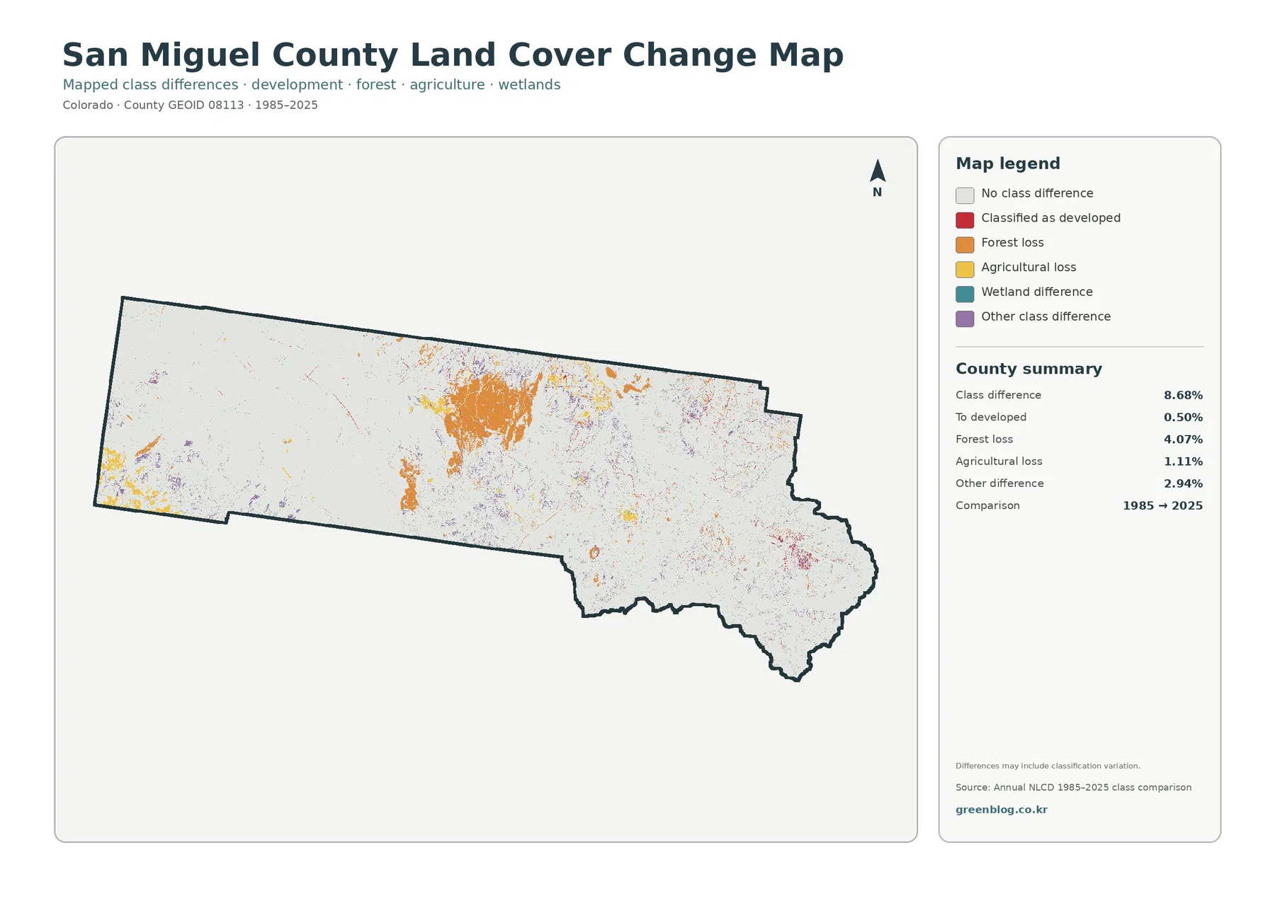
The change map compares the class assigned to each location in 1985 with the class assigned in 2025. It reports a total class difference of 8.68%. The summary identifies 0.50% as change classified to developed, 4.07% as forest-loss classification, 1.11% as agricultural-loss classification, and 2.94% as other class difference.
A large orange patch in the central portion is one of the most visible features on the change map, and smaller difference cells are scattered along forest boundaries and other parts of the county. Orange means a location classified as forest in the earlier comparison is assigned to another class in 2025. It does not prove that the same percentage represents permanent forest destruction.
The 8.68% total should likewise not be presented as a development rate, a disturbance rate, or a direct measure of environmental damage. Real landscape change can contribute, but image date, vegetation condition, fire and recovery, mixed pixels, and classification methods can also affect the assigned class. A cause requires additional evidence.
The most useful way to work with this map is to identify areas for follow-up. A red developed-change patch can be compared with the current impervious map to see whether hard surfaces are concentrated there today. A forest-loss classification can be checked against the 2025 forest map and, when needed, against intermediate Annual NLCD years, aerial photography, fire records, or field information.
County planning sources help place the map in a local context
San Miguel County’s Open Space Commission states that its work includes conserving open space, natural habitat, agricultural lands, and scenic resources. That county goal is useful context for a map where natural cover dominates, but the land-cover layer itself does not identify conservation status. A forest or shrubland cell may be public, private, protected, or unprotected.
The county Master Plan page separates materials for Wrights Mesa, the East End, Open Lands, trails, and the Telluride region. That organization reflects the fact that San Miguel County contains very different settings within one boundary. The land-cover maps show a similar geographic contrast: shrub-dominated western terrain, forested eastern mountains, small agricultural areas, and compact developed clusters.
The official Open Lands map identifies Norwood, Placerville, Sawpit, Telluride, Mountain Village, and Ophir. These place names are useful for orientation when comparing the land-cover and impervious maps. They should not be used to infer exact municipal boundaries from the raster, because the map images are designed for county-scale pattern reading rather than local boundary work.
Annual NLCD is raster data, meaning the landscape is represented by cells with a representative value. Narrow roads, tiny wetlands, stream edges, scattered buildings, and mixed vegetation can be simplified when several surface types fall within the same cell. That is why these maps are appropriate for countywide comparison and education but not as substitutes for parcel surveys or site-specific environmental work.
Choosing the right map for a specific task
- Use the 2025 land-cover map when you need the full mix of forest, shrubland, barren land, grassland, agriculture, wetlands, water, and developed cover in one view.
- Use the forest-and-farmland map when the main question is where forest dominates and where the relatively small agricultural patches occur.
- Use the impervious-surface map to compare the compact built clusters around Telluride–Mountain Village, Norwood, and other smaller settlement areas.
- Use the 1985–2025 difference map to locate cells that changed classification and then check those places against current maps or additional time-series sources.
For a presentation, the four-map sequence can move from the broad landscape to more focused questions. Start with current land cover, then isolate forest and agriculture, switch to impervious surface for settlement patterns, and finish with the time comparison. Keeping the year and legend visible prevents the current-state maps and the change map from being mistaken for the same type of measurement.
For environmental education or watershed discussions, the maps can also be used to show how small water and wetland features sit within much larger forest and shrubland systems. Any detailed conclusion about habitat condition, stream function, ownership, or management should be checked against more specialized data because the land-cover product is a generalized regional layer.
Download the four San Miguel County JPG maps
The ZIP below contains the four original JPG maps used for this page: 2025 land cover, forest and farmland, impervious surface and developed land, and the 1985–2025 class-difference map. Each image is 2480×1754 pixels. The supplied asset manifest does not mark these files as meeting its A3 high-resolution reference, so large-format printing or detailed analysis may require the original Annual NLCD data or another higher-resolution source.
Frequently Asked Questions
What are the largest land-cover classes in San Miguel County?
Forest covers 47.11% of the 2025 summary and shrubland 45.29%. Together they account for most of the county.
Where are impervious surfaces most concentrated?
The clearest concentration is around Telluride and Mountain Village in the east, with a smaller cluster near Norwood. Countywide mean impervious surface is 0.37%.
Does the 8.68% class difference mean 8.68% of the county was damaged?
No. It is the share of cells assigned to different land-cover classes in 1985 and 2025. Real change can contribute, but observation and classification differences can also affect the result. Map File Information The ZIP contains four original JPG maps: 2025 land cover, forest and farmland, impervious surface and developed land, and 1985–2025 class differences.
Map File Information
Download the map files associated with this page for reference, printing, and compatible visual projects.
- Included Files: Use only the versions confirmed in the article and supplied images
- File Type: Use the confirmed download contents
- Intended Use: Printing, education, presentations, and map-based projects
Related Maps
- Adams County Colorado Land Cover Map
- Alamosa County Colorado Land Cover Map
- Arapahoe County Colorado Land Cover Map
Sources and References
- MRLC Annual NLCD Data – source portal for Annual NLCD land-cover data and time-series products.
- USGS Annual NLCD Land Cover Classification – explanation of the land-cover classes used in the dataset.
- U.S. Census Bureau TIGER/Line Shapefiles – official county boundary reference.
- San Miguel County Open Space Program – county information on open-space, habitat, and agricultural-land conservation.
- San Miguel County Master Plan – county planning materials for Wrights Mesa, the East End, Open Lands, and the Telluride region.
- San Miguel County Open Lands Plan Map – official map showing towns, planning areas, roads, streams, and land management.
Green Map creates custom-edited map images using open geographic data sources such as geoBoundaries, Natural Earth, OpenStreetMap, and government open data.
These maps are edited visual materials, not raw data files, and are provided for education, documents, presentations, and graphic reference.