The Cyprus Map in this collection does more than trace a familiar Mediterranean island: it separates six districts, identifies major cities, and shows the UN buffer zone and the British Sovereign Base Areas. Three supplied versions present that information at different levels—a labeled color map, a labeled black-and-white map, and an unlabeled outline. Together, they support geographic reference, classroom explanation, monochrome documents, route planning, and custom annotation without forcing every reader to work from the same visual density.
Cyprus lies in the eastern Mediterranean, south of Türkiye and west of Syria and Lebanon. Its long east–west profile is easy to recognize, especially the narrow Karpas Peninsula reaching northeast from the main body of the island. Nicosia occupies an inland position near the center, while Paphos, Limassol, Larnaca, Famagusta, and Kyrenia provide coastal reference points. That combination of a distinctive coastline and a divided administrative landscape makes the island much easier to explain visually than through a list of place names.
The Cyprus Map set helps readers distinguish formal district geography from present-day control on the ground. It can support lessons, regional comparisons, and historical timelines, but it should be treated as geographic reference rather than a navigation chart because roads and terrain are not shown.
Table of Contents
Why the Cyprus Map Needs More Than an Island Outline
Cyprus is formally divided into six districts: Nicosia, Famagusta, Kyrenia, Larnaca, Limassol, and Paphos. On the color and black-and-white versions, these names appear inside the appropriate regions, while city markers help distinguish a district from the city that shares its name. This is especially helpful with Nicosia, the inland capital, and with coastal names such as Paphos, Limassol, Famagusta, and Kyrenia.
The district pattern alone does not fully explain the island. Since 1974, the northern and southern parts have been separated by a ceasefire area commonly called the Green Line. The UN-controlled buffer zone runs for approximately 180 kilometers and passes through Nicosia. It is not a seventh district, so the gray corridor should be read as a special zone rather than an ordinary administrative unit.
Two additional areas require a separate map symbol. Akrotiri, on the southern coast, and Dhekelia, in the southeast, are British Sovereign Base Areas retained by the United Kingdom when Cyprus became independent in 1960. The color version uses a red patterned fill for them, clearly separating them from both the six districts and the gray buffer zone. This distinction matters because neither base area should be interpreted as a neighboring country or a Cypriot district.
Three Ways to Read the Island
All three images share the same recognizable coastline and internal geometry, but they answer different questions. The color sheet emphasizes classification, the monochrome sheet emphasizes names and lines, and the outline removes labels for custom work.
Color Map for Districts and Special Areas
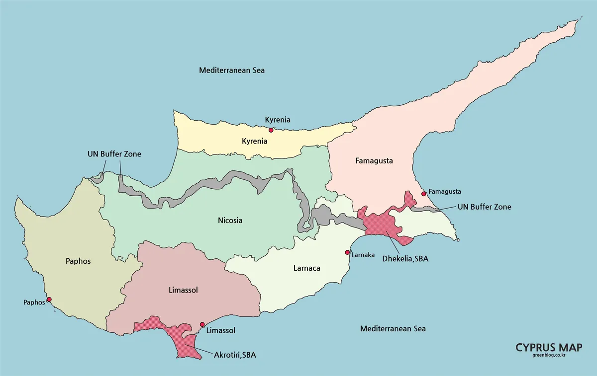
The color Cyprus Map offers the fastest overview of the island’s administrative pattern. Paphos fills the west, Limassol spans much of the south, Larnaca occupies the southeast, and Nicosia extends across the central interior. Kyrenia forms a narrow northern band, while Famagusta includes the long northeastern peninsula. These shapes show why district comparisons are difficult to grasp from a simple list: the regions differ sharply in orientation, coastline, and extent.
Color prevents the UN corridor and the two Sovereign Base Areas from blending into adjacent districts. Red points locate five coastal cities, while Nicosia is identified within the central district. The layout can support a presentation about the island’s division or a classroom explanation of its districts.
Black-and-White Map for Labels and Printed Documents
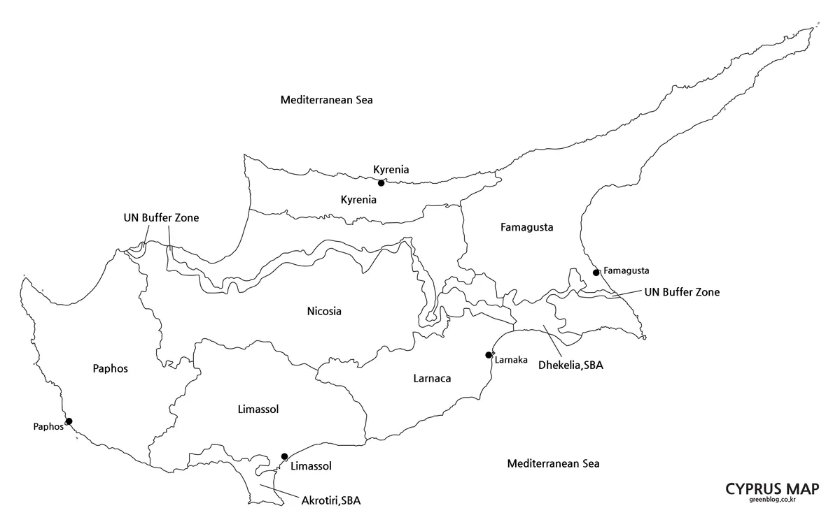
The black-and-white Cyprus Map keeps district boundaries, city dots, place names, buffer-zone labels, and base-area labels while removing broad color fills. Attention shifts toward text and linework, yet the long Karpas Peninsula and narrow northern district remain easy to distinguish.
This sheet suits reports and worksheets printed without color. Students can underline district names, circle coastal cities, or compare the two separated base areas. The gray buffer zone remains readable against the white districts, preserving its visual distinction from ordinary boundaries.
Outline Map for Annotation and Custom Projects
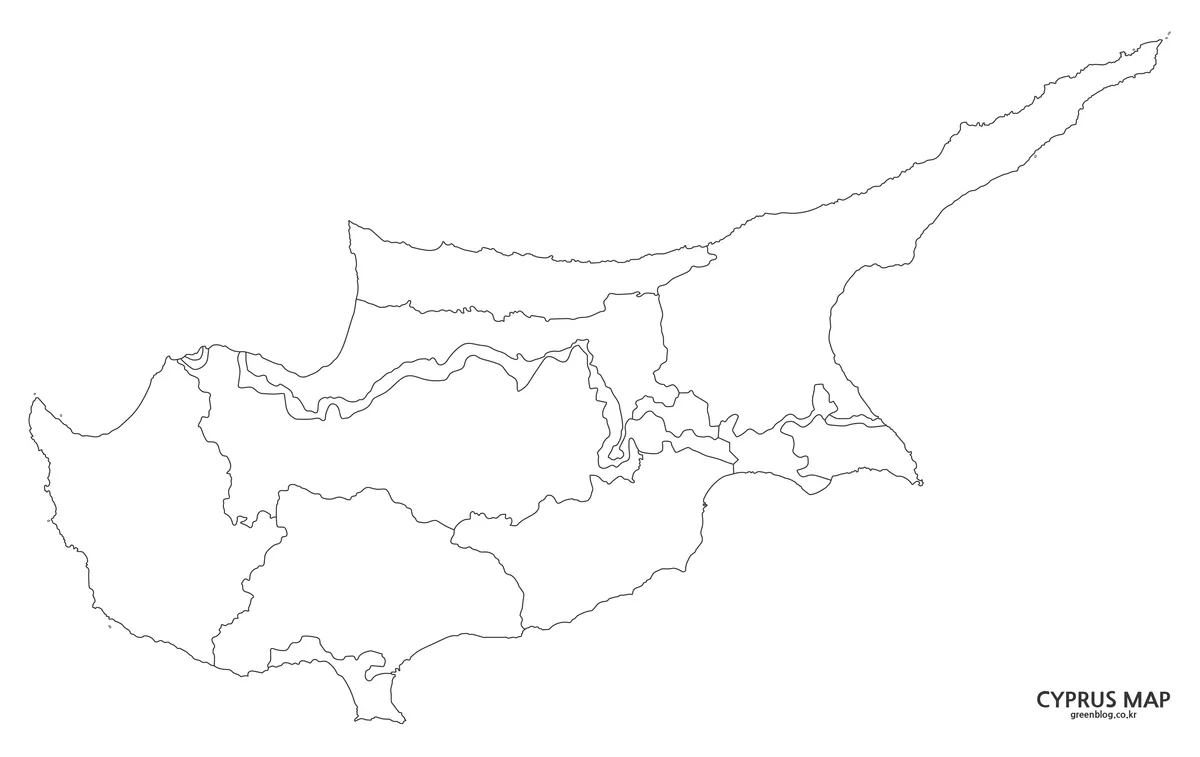
The outline Cyprus Map preserves the coast, six-district framework, buffer-zone geometry, and base-area boundaries but removes names, city points, and fills. A teacher could ask students to label the districts and coastal cities, shade the north and south differently, or trace the Green Line through Nicosia.
The blank structure can carry statistics, travel routes, historical events, or regional groupings. A route diagram could connect Paphos, Limassol, Larnaca, and Famagusta along the coast while marking Nicosia separately inland. Advanced worksheets can use the retained internal lines as district-identification prompts.
Choosing the Right Cyprus Map
Choose the color version when the distinction among districts, the UN buffer zone, and the British areas must be understood immediately. It carries the most visual information and is the strongest choice for projected lessons or infographics. The black-and-white map is preferable when labels need to remain visible in a monochrome report or when students will add short notes around an existing reference framework.
Use the outline version when the activity itself involves completing the geography. Its empty spaces leave room for district names, city symbols, arrows, dates, or color-coded data. For a multi-stage lesson, the three versions can be used in sequence: introduce the structure with color, review it with the monochrome reference, and test recognition or add new information on the outline.
Practical Reading and Layout Notes
The east–west shape creates a layout challenge. Enlarging the island enough to make Nicosia and the central buffer-zone bends readable pushes the Karpas Peninsula toward the upper-right edge. The landscape composition keeps Akrotiri and Dhekelia visible while leaving sea space for labels.
When adding the Cyprus Map to a presentation, avoid cropping tightly around the central districts; the peninsula tip or western coastline could disappear. Worksheet instructions can occupy the open sea area. At small display sizes, use color for area recognition or the outline for drawing because labels may become difficult to read.
The collection gives readers a progression from explanation to participation: color clarifies the island’s unusual territorial pattern, monochrome preserves a clean labeled reference, and the outline invites new information. Used together, the three versions make it possible to explain not only where Cyprus is, but also why its administrative boundaries and present-day division need to be read with care.
Frequently Asked Questions
How many districts are shown on the maps?
The maps show six districts: Nicosia, Famagusta, Kyrenia, Larnaca, Limassol, and Paphos. These are formal administrative divisions. The UN buffer zone and the British Sovereign Base Areas are displayed separately because their status and function differ from those of the six districts.
What does the gray band across the Cyprus Map represent?
The gray band represents the UN buffer zone, also known as the Green Line. It extends across the island for about 180 kilometers and passes through Nicosia. It should not be counted as another district, and its width on the ground is not uniform along the entire route.
What are the red patterned areas on the color version?
They identify Akrotiri and Dhekelia, the two British Sovereign Base Areas. Akrotiri lies on the southern coast near Limassol, while Dhekelia occupies a southeastern position near Larnaca and Famagusta. Their patterned treatment separates them from colored Cypriot districts and from the gray UN zone.
Which version is best for classroom labeling?
The outline version provides the most room for students to add district names, mark Nicosia, identify coastal cities, or shade the buffer zone. The black-and-white version is better as an answer key or reference sheet because it already contains the main labels and city points without relying on color.
Does the outline image show only the coast?
No. It removes text, points, and fills, but retains the internal district lines along with the outlines of the buffer zone and Sovereign Base Areas. This makes it suitable for more detailed exercises than a completely empty island silhouette while still allowing extensive annotation.
Are roads, elevation, and tourist sites included?
No roads, terrain shading, elevation data, or attraction symbols are visible in the supplied set. The three images focus on the coastline, districts, selected cities, and special political areas. A separate road or travel map should be used when precise navigation is required.
Map File Information
This collection provides three Cyprus map images for geographic reference, printed documents, classroom activities, presentations, and custom annotation.
- Included Versions: Color map, black-and-white map, and outline map
- File Type: Image files
- Intended Use: Reference sheets, classroom exercises, presentations, reports, and custom map projects
Related Maps
- Greece Map – Color, Black-and-White, and Outline Maps
- Georgia Map with Regions, Tbilisi, and the Black Sea
- Switzerland Map with 26 Cantons and Major Lakes
- Hungary Map with 19 Counties and Budapest
Additional Resources
- UNFICYP: About the Buffer Zone: Learn how the UN buffer zone crosses Cyprus, why its width varies, and how it is managed.
Green Map creates custom-edited map images using open geographic data sources such as geoBoundaries, Natural Earth, OpenStreetMap, and government open data.
These maps are edited visual materials, not raw data files, and are provided for education, documents, presentations, and graphic reference.