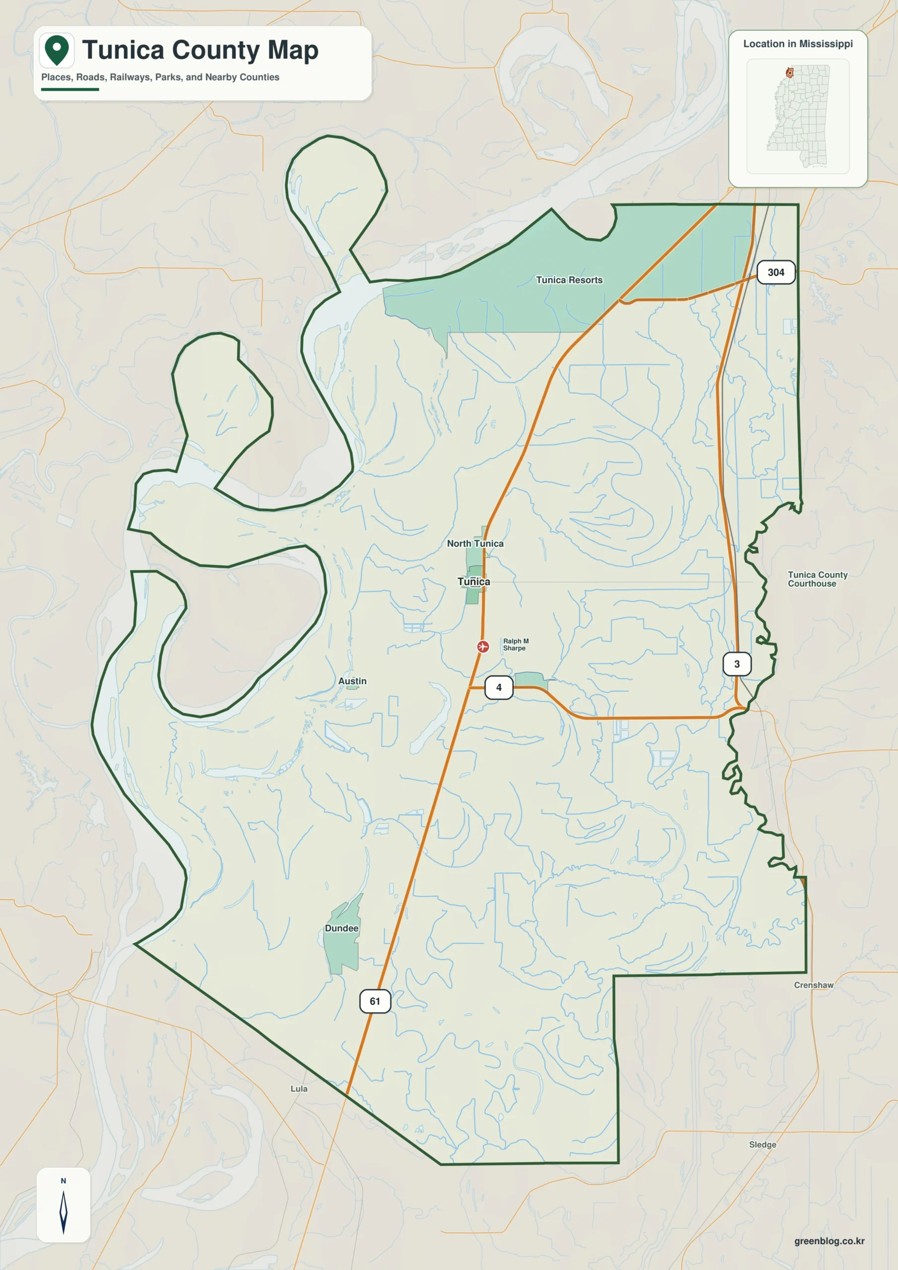
The Tunica County Mississippi map separates Tunica, the southern county seat, from Tunica Resorts, North Tunica, and Dundee farther north. The Mississippi River, levees, abandoned channels, and US 61 add a tourism and resort corridor to an otherwise agricultural Delta county.
Tunica County Mississippi map download
The WebP preview is optimized for the page, while the button preserves the original high-resolution JPG for printing and reuse.
- File: County reference map
- Format: JPG
- Print layout: A3
Quick Facts
- State and identifier: Mississippi, Tunica County; FIPS 28143
- County seat: Tunica
- Selected map labels: Tunica, Tunica Resorts, North Tunica, Dundee, Commerce
- 2020 census population: 9,782
- July 2025 population estimate: 8,819
- 2025 Gazetteer area: 454.130 sq mi land and 22.013 sq mi water
- 2020 land-area density: 21.5 residents per sq mi
- Primary route references: US 61, MS 3, MS 4, and Casino Center Drive
- Landscape references: Mississippi River, Tunica Cutoff, oxbow lakes, levees, Delta farmland, and casino resort district
The decennial count and July 2025 estimate use different reference dates. Land and water measurements come from the 2025 Gazetteer. The density of 21.5 residents per square mile divides the 2020 population by 2025 land area and does not imply an even distribution among cities, farms, forest, or wetland.
Reading the Tunica County Mississippi map
US 61 leads north from Tunica toward Tunica Resorts and DeSoto County, while MS 3 serves the eastern agricultural side from north to south. MS 4 provides the Tate County approach east of Tunica. Casino parking lanes, service drives, and levee maintenance roads are not all shown.
Boundary, Water, and Terrain
The Mississippi River forms the Arkansas side and creates broad floodplain land, bends, and cutoff lakes such as Tunica Cutoff. Straight drainage canals and large fields repeat east of the levee. Tunica town and the river-oriented resort district are geographically separate and should not be read as one continuous city.
Where Mississippi River and Tunica Cutoff shapes the county, 454.130 square miles of land contrast with a water share of about 4.6 percent. Mississippi River and Tunica Cutoff is therefore a directional clue, not merely a patch of blue. Tunica and Tunica Resorts establish an internal baseline, while the side facing DeSoto supplies an outer reference. Exact access near Mississippi River and Tunica Cutoff should be checked with a current transportation or land-management source.
Settlement and Regional Context
Tunica contains courthouse and local services, while Tunica Resorts concentrates hotels, casinos, event facilities, and tourism employment. Northern areas also feel the influence of metropolitan Memphis. The July 2025 estimate is about 9.9 percent below the 2020 base, although accommodation activity remains large relative to population.
Practical Map Uses
- Distinguish Tunica from Tunica Resorts
- Follow US 61 toward metropolitan Memphis
- Compare river levees with the agricultural grid
Frequently Asked Questions
Is Tunica Resorts the downtown of Tunica?
No. The hotel and casino district lies north of the county seat. A useful map labels the two places separately.
Why compare Mississippi River with Tunica before reading the side toward DeSoto?
Tunica is a settlement anchor, while Mississippi River supplies a physical reference for separating the county interior from the approach to DeSoto.
Sources
- U.S. Census Bureau QuickFacts
- U.S. Census Bureau 2025 Gazetteer Files
- Mississippi Department of Transportation official highway map
- Regional landscape or institution reference
Related County Maps
Green Map creates custom-edited map images using open geographic data sources such as geoBoundaries, Natural Earth, OpenStreetMap, and government open data.
These maps are edited visual materials, not raw data files, and are provided for education, documents, presentations, and graphic reference.