The Sharkey County Mississippi map centers on Rolling Fork, with Anguilla to the north, Cary to the south, Delta City in the east, and Panther Burn in the northwest. Deer Creek, the Big Sunflower River, and Delta National Forest reveal wetland and forest structure within otherwise flat agricultural land.
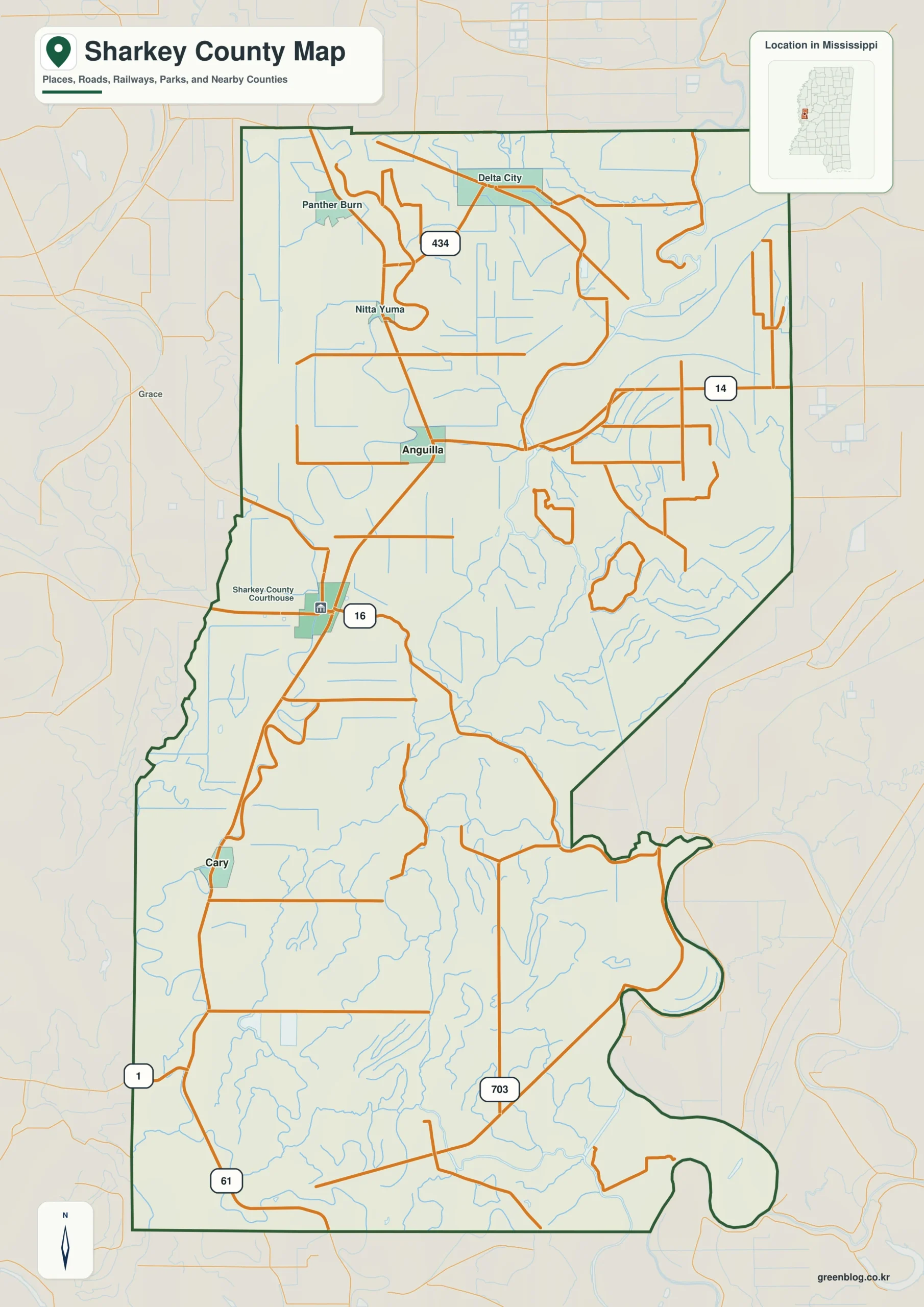
Sharkey County Mississippi map download
The WebP preview is optimized for the page, while the button preserves the original high-resolution JPG for printing and reuse.
- File: County reference map
- Format: JPG
- Print layout: A3
Quick Facts
- State and identifier: Mississippi, Sharkey County; FIPS 28125
- County seat: Rolling Fork
- Selected map labels: Rolling Fork, Anguilla, Cary, Delta City, Panther Burn
- 2020 census population: 3,800
- July 2025 population estimate: 3,097
- 2025 Gazetteer area: 431.720 sq mi land and 3.400 sq mi water
- 2020 land-area density: 8.8 residents per sq mi
- Primary route references: US 61, MS 14, MS 16, and MS 1
- Landscape references: Delta National Forest, Deer Creek, Big Sunflower River, alluvial farmland, wetlands, and bayous
The decennial count and July 2025 estimate use different reference dates. Land and water measurements come from the 2025 Gazetteer. The density of 8.8 residents per square mile divides the 2020 population by 2025 land area and does not imply an even distribution among cities, farms, forest, or wetland.
Reading the Sharkey County Mississippi map
US 61 runs from Anguilla through Rolling Fork toward Cary and Issaquena County. MS 14 provides the eastern Humphreys County approach, MS 16 leads west toward Washington County, and MS 1 serves the Delta City side. Levee tracks, farm entrances, drainage roads, and forest roads are selectively omitted.
Boundary, Water, and Terrain
Deer Creek winds beside towns and farms, while the Big Sunflower River crosses eastern lowlands. Delta National Forest protects floodplain hardwood forest and wetlands in the western and southern county. Because relief is minimal, river bends, abandoned channels, drainage ditches, and US 61 provide better orientation than ridges.
Settlement and Regional Context
Rolling Fork concentrates courthouse and local services, and recovery from the destructive 2023 tornado continues to influence the built landscape. Anguilla and Cary are smaller US 61 agricultural centers. The July 2025 estimate is about 18.5 percent below the 2020 base, the largest decline in this ten-county batch.
Practical Map Uses
- Sequence Anguilla, Rolling Fork, and Cary on US 61
- Compare Delta National Forest with cultivated land
- Distinguish Deer Creek from the Big Sunflower River
Frequently Asked Questions
Does Delta National Forest mean the entire Mississippi Delta?
No. It is a specific federally managed forest containing floodplain habitat. It should be distinguished from the much broader regional term Mississippi Delta.
How can Delta National Forest clarify the part of Sharkey County facing Washington?
Looking only at Rolling Fork would reduce the map to town labels, whereas Delta National Forest explains the landscape transition toward Washington.
Sources
- U.S. Census Bureau QuickFacts
- U.S. Census Bureau 2025 Gazetteer Files
- Mississippi Department of Transportation official highway map
- Regional landscape or institution reference
Related County Maps
Green Map creates custom-edited map images using open geographic data sources such as geoBoundaries, Natural Earth, OpenStreetMap, and government open data.
These maps are edited visual materials, not raw data files, and are provided for education, documents, presentations, and graphic reference.